The main purpose of this ongoing blog will be to track planetary extreme, or record temperatures related to climate change. Any reports I see of ETs will be listed below the main topic of the day. I’ll refer to extreme or record temperatures as ETs (not extraterrestrials).😉
Main Topic: Astounding Record Warmth Slated for the Eastern and Southern U.S.
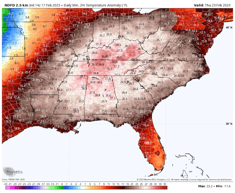
Dear Diary. It’s not even spring yet and portions of Florida are facing a week of 90°F-95°F temperatures, brought about by an astoundingly large and strong heat done by February standards. Earlier this week I kibitzed with some of my on-air meteorologist friends about this occurrence:
Record heat won’t be confined to Florida and should affect most of the southern and eastern United States after Monday. This warmth, beyond being eye-opening and a break from typical February chill, will have severe weather consequences as it interacts with yet another strong storm system moving eastward from the Rockies:
It’s already been a warm February for most of the eastern United States. For example:
And this winter there has been very little snowfall for this winter at most eastern locations, so far:
As promised, I am starting to report on this February 2023 “warm wave.” Here is more from the Washington Post:
Surge of warmth just set February records in the East, with more on the way – The Washington Post
Surge of warmth just set February records in the East, with more on the way

February 17, 2023

It was another week of numerous record highs and warm nighttime lows, from the Great Lakes to the Northeast. In addition to calendar day records, a number of monthly records were also toppled.
The peak of this warm wave came along Wednesday into Thursday. Although very mild temperatures persisted into early Friday in much of the Northeast, a cold front was beginning to sweep the toasty February conditions out of the region.
Great Lakes ice cover plummets to record mid-February low
Readings more typical of mid-February are on tap to sweep into the Northeast into the weekend. It’s a short stay, as another bubble of odd wintertime warmth expands northward through the middle of next week, which could set even more records.
Records already set
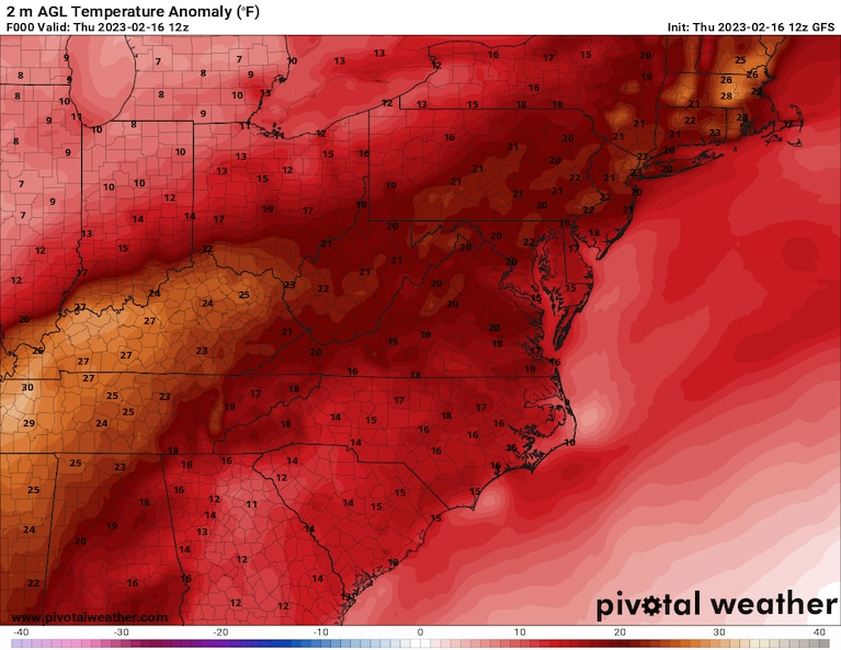
Dozens of daily high temperature records were set up and down the East Coast on Thursday. Temperatures surged into the mid-80s in several locations across Florida, the mid-70s in southwest Virginia and into the low and mid-50s in northern Vermont. Highs in the 60s and 70s across Rhode Island, Connecticut and Massachusetts set records for the entire month of February, according to climate expert Maximiliano Herrera.

Temperatures were 20 to 30 degrees above normal over a huge area Thursday morning. (Pivotal Weather)
Here’s a selected list of locations that established February record highs Thursday:
- Islip, N.Y.: 71 degrees (old: 68 degrees, including last year)
- Bridgeport, Conn.: 68 degrees (old: 67 degrees, including last year)
- Bedford, Mass.: 72 degrees (old: 70 degrees, data since 1996)
- Newport, R.I.: 69 degrees (old: 63 degrees, data since 1996)
Thursday’s scores of records along the East Coast followed a similar number farther to the west Wednesday.

Around New York City, it was also as warm as it gets in February at night. Two observing sites there notched one of their top two warmest February low temperatures Thursday morning.
- NYC Central Park: Second-warmest at 56 degrees (warmest: 58 degrees in 2017)
- NYC LaGuardia: Warmest at 54 degrees (ties 54 degrees in 1985)
Many more locations broke records for warm lows Feb. 16, including Boston, with 46 degrees, and Albany at 38 degrees. Even farther south, Tri-Cities, Tenn., registered a record warm low of 52 degrees that day.
Stations in Bridgeport, Islip, Newark, Boston and Providence, R.I., among others also logged one of their top-10 warmest lows for February.
More next week
A larger surge of warm temperatures seems set to occur next week.
The Weather Prediction Center is highlighting the potential for widespread record highs and record high lows next Wednesday and Thursday.
Temperatures in the Southeast and Florida are poised to head deep into the 80s or near 90 in spots. The Carolinas and Mid-Atlantic can expect readings well into the 70s to perhaps near 80.

On the other side of the Lower 48, a dip in the jet stream and Arctic air spilling into the region are set to bring the potential for record lows from Washington state to California and perhaps into the Intermountain West.
It will be quite the dynamic temperature environment mid- to late next week across the Lower 48. On Thursday, there could be widespread high temperatures of 25 to 35 degrees above normal in the East but as much as 40 degrees below normal in the northern Plains.
Winter’s never-ending story
Pulses of unusually high temperatures have continued to roll through the eastern half of the country since the beginning of the year: 2023 opened with what we described as a burst of bewildering warmth.
A majority of climate locations from Maine to the Mid-Atlantic are in the running for one of their top-five warmest climatological winters (December through February) on record, despite impressive Arctic blasts in December and early this month. This includes Washington, D.C.
Much of the broader region has now seen numerous top-end warm winters over recent decades. The increasing frequency of such events is a hallmark of human-caused climate change.
How a predicted polar-vortex disruption could spur winter’s revenge
There continue to be predictions of more persistent cold late in February and into March.
If the cold does eventually arrive, it will be battling an increasingly hostile environment typical of approaching spring, such as rising temperature averages and an increasingly powerful sun. It also still remains uncertain as to how much the pattern will actually change, and how enduring it might be.

By Ian Livingston Ian Livingston is a forecaster/photographer and information lead for the Capital Weather Gang. By day, Ian is a defense and national security researcher at a D.C. think tank. Twitter
More:
Here are some “ET’s” recorded from around the planet the last couple of days, their consequences, and some extreme temperature outlooks, as well as any extreme precipitation reports:
Here is more climate and weather news from Saturday:
(As usual, this will be a fluid post in which more information gets added during the day as it crosses my radar, crediting all who have put it on-line. Items will be archived on this site for posterity. In most instances click on the pictures of each tweet to see each article. The most noteworthy items will be listed first.)
If you like these posts and my work please contribute via the PayPal widget, which has recently been added to this site. Thanks in advance for any support.)
Guy Walton… “The Climate Guy”