The main purpose of this ongoing blog will be to track planetary extreme, or record temperatures related to climate change. Any reports I see of ETs will be listed below the main topic of the day. I’ll refer to extreme or record temperatures as ETs (not extraterrestrials).😉
Main Topic: The Future of Heatwave Exxon
Dear Diary. The heatwave that I’ve dubbed Exxon has lasted longer than any other that I’ve named since 2021. The worst U.S. heatwaves last practically all summer long with no break coming from Canadian cool airmasses. A bad tropical season has many named storms, but a bad summer season has only one or two historic heatwaves lasting for its entirety. A heatwave remains one entity in my system as long as its 500 millibar heat dome is apparent on charts.
I’m going to stress here that beyond producing records and stats, Heatwave Exxon will cause real health issues from people being just uncomfortable, to heat strokes, and even deaths. It is a climate crisis item that must be paid attention to with unprepared folks suffering bad consequences.
Exxon recently was historic in nature across New England and southern Canada where Maine set records for heat:
So, Exxon was briefly a CAT4 across New England and Southern Canada since it produced monthly and a few all-time records, but a front put an end to high heat there. Exxon remains a dangerous major CAT3 across the Midwest and the remainder of the Northeast looking at current National Weather Service advisories:

On Wednesday Exxon was at its peak at 500 millibars with a center near 600 decameters:
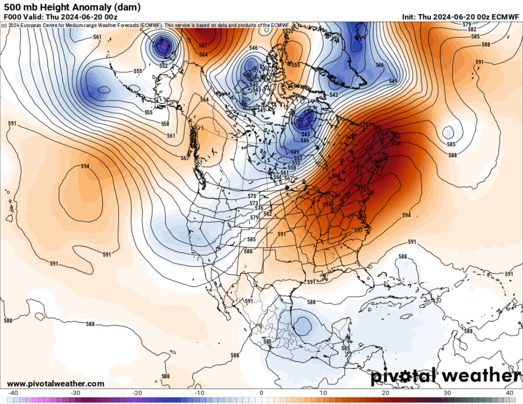
The center of Exxon has been decreasing in height, thus cooling thankfully, and will retrograde into the South as of this Friday:
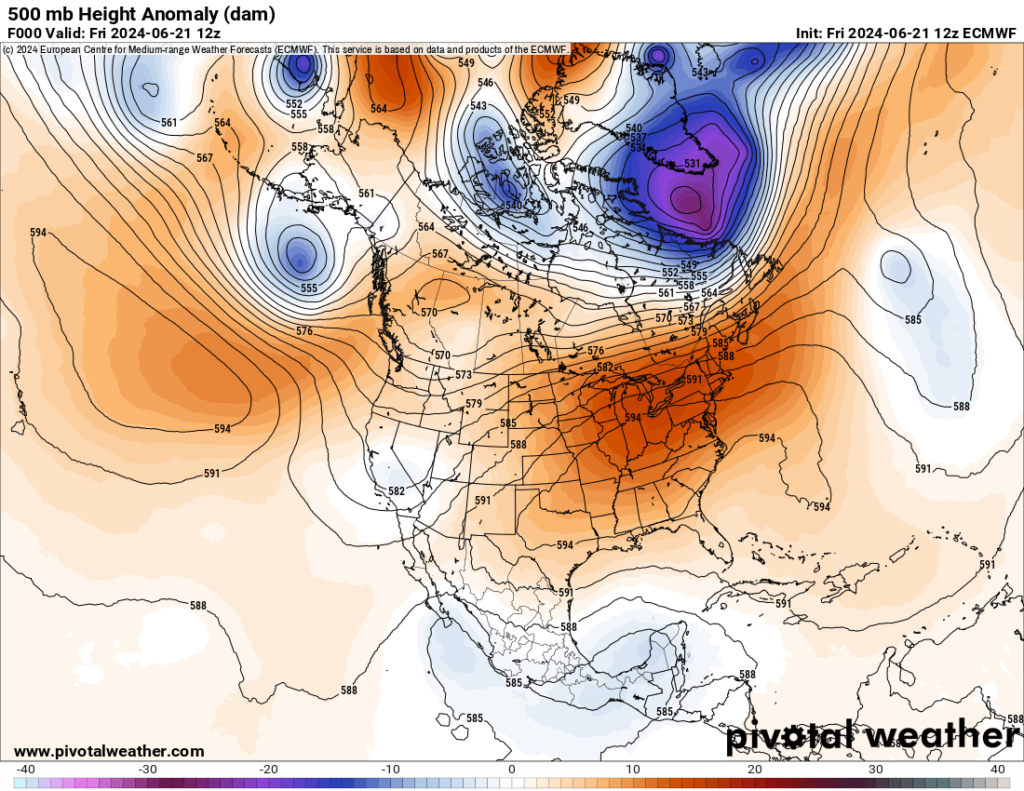
We still have a sprawling 594+ decameter heat dome, thus today’s maxes will be quite high, or above average, across most of the country:
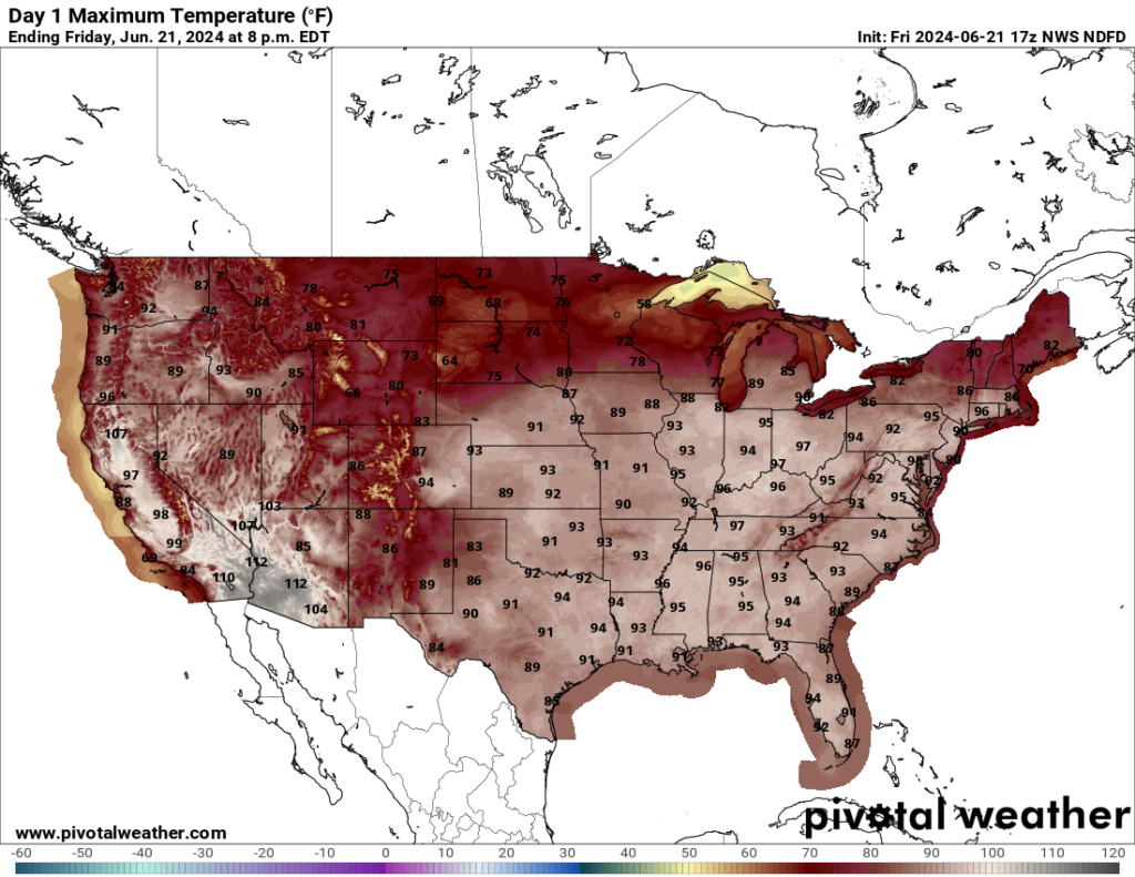
Exxon’s heat dome will continue to retrograde until it sets up camp over the Southwest by the middle of next week:

Still, we will continue to see above average temperatures east of the Rockies with excessive heat across the Southwest:
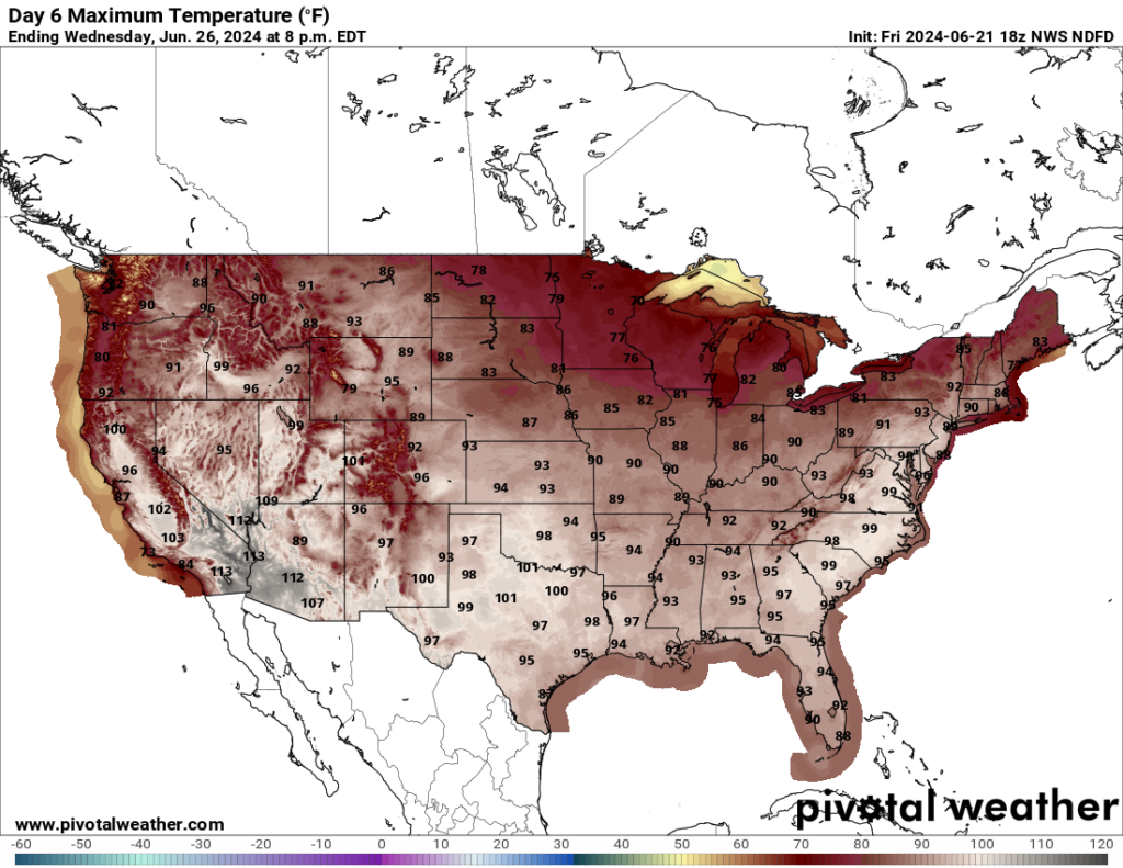
Exxon should have another nadir late next week then build back into the Southeast in response to another cool system digging into the Pacific Northwest:

So essentially Exxon will remain a dangerous CAT3 for the remainder of June going into July with health concerns. Will we see it build towards being a historic CAT4 again or diminish to a CAT2? Stay tuned.
The Washington Post’s Record Outlook:
Live updates: Heat wave shifting from Northeast U.S. to Midatlantic – The Washington Post
Here are records that could be set through the weekend

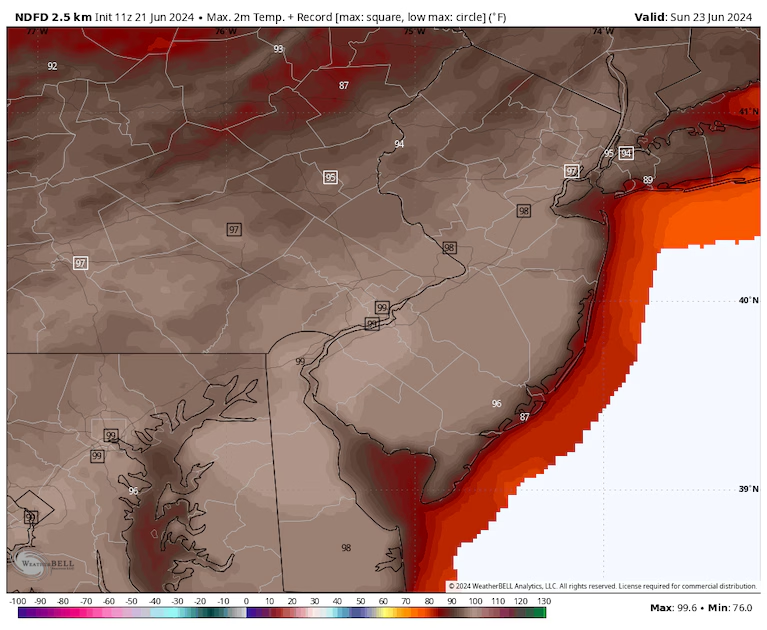
Many records are forecast Sunday from Washington to New York City. (weatherbell.com)
Calendar day records will be numerous through the weekend from the Lower Great Lakes to the Mid-Atlantic as highs range from the mid-90s to around 100, with lows only in the 70s to around 80.
Possible records on Friday
Dozens of record warm lows are likely toppled from the Midwest to New England. A number of record highs will also be threatened as the focus of heat begins to shift south and east.
Potential records include:
- New Brunswick, N.J., where the forecast is 96, and the record is 97.
- Morgantown, W.Va., where the forecast is 94, and the record is 95.
- Louisville, where the forecast is 98, and the record is 98.
Possible records on Saturday
Records should be somewhat more numerous. Some spots to watch:
- Dulles, Va., where the forecast is 99, and the record is 99.
- Harrisburg, Pa., where the forecast is 98, and the record is 97.
- Columbus, Ohio, where the forecast is 96, and the record is 97.
Possible records on Sunday
This will probably be the biggest day for record highs, partly because historical records are slightly lower than preceding days.
Records at risk include:
- New York City, where the forecast is 94, and the record is 96.
- Philadelphia, where the forecast is 99, and the record is 97.
- Washington, where the forecast is 99, and the record is 98.
- Norfolk, where the forecast is 98, and the record is 99.
Sunday may feature more than 100 record warm lows sprawled from the southern Great Lakes to the East Coast. Some places, such as D.C., are forecast to witness lows of 80 or higher.
Here’s how hot it got on Thursday


By Jason Samenow and Ian Livingston
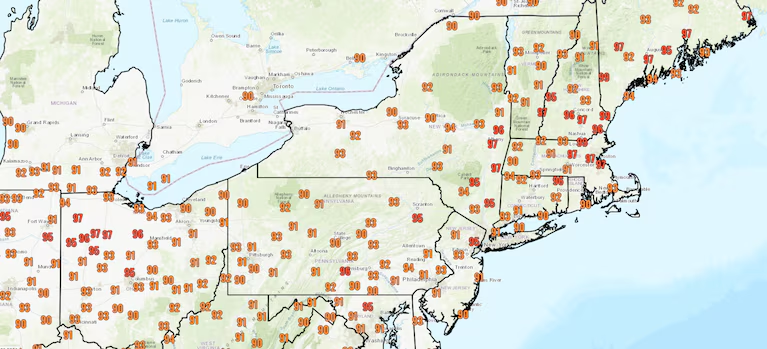
High temperatures Thursday. Only highs of at least 90 are displayed. (National Weather Service)
The core of the heat Thursday stretched from eastern Indiana to eastern Maine, where highs reached the mid-90s. Within this zone, a few locations in New England and Ohio even reached the upper 90s.
Factoring in humidity, heat indexes climbed as high as 100 to 110.
Here are some of the records that were set:
- Hartford, Conn., set a calendar day high of 98.
- Manchester, N.H., hit 97 for a third straight day, matching the longest streak on record in any month.
- Boston reached 97 degrees, marking only the second time on record it has been at least that hot on consecutive days in June.
- Bangor, Maine, set a calendar day high of 96.
- Avoca, Pa., tied a calendar day high of 95.
- Albany, N.Y., tied a calendar day high of 94.
- Portland, Maine, set a calendar day high of 94.
- Dubois, Pa., set a calendar day high of 91.
In eastern Canada, all-time high temperature records were set in Saint John with highs of 35.1 Celsius (95.2 degrees); Chevery at 32.7 C (90.9 degrees); and Terra Nova at 35.4 C (95.7 degrees). Halifax, Nova Scotia, also joined a group of Atlantic Canadian cities in setting a monthly record for June, climbing to 35.3 Celsius (95.5 degrees).
Over the past week, even with a relatively substantial number of cold records to the west of the heat dome in the northern Rockies, daily heat records have outpaced daily cold records by a factor of four.
Here are more “ETs” recorded from around the planet the last couple of days, their consequences, and some extreme temperature outlooks, as well as any extreme precipitation reports or outlooks:
Here is some more May 2024 climatology (Prior reports are listed on older daily diary blogs for each calendar day.):
Here is More Climate News from Friday:
(As usual, this will be a fluid post in which more information gets added during the day as it crosses my radar, crediting all who have put it on-line. Items will be archived on this site for posterity. In most instances click on the pictures of each tweet to see each article. The most noteworthy items will be listed first.)