The main purpose of this ongoing blog will be to track planetary extreme, or record temperatures related to climate change. Any reports I see of ETs will be listed below the main topic of the day. I’ll refer to extreme or Main Topic: Biden Spells Out Climate Goals That Will Be Ignored by Trump temperatures as ETs (not extraterrestrials).😉
Main Topic: A Colder Than Average January in the Offing for the U.S.?
Dear Diary. It has been quite a long time since the United States had a below average month, temperature wise. My meteorological tea leaves for the last week have been suggesting that January 2025 could indeed be that month.
Interestingly, the nearest month in the recent past coming close to being below average was January 2024. Here are many details from my latest record scoreboards:


DHMX= Daily High Max Reports. DLMN= Daily Low Min Reports. DHMN= Daily High Min Reports. DLMX=Daily Low Max Reports.
Boldly highlighted red, blue, or purple colored months, such as December 2023 and June 2021, that have ratios of >10 to 1 daily or <1 to 10 of daily warm to low records are either historically hot or cold, most of which have made news. NCEI rankings are for the lower 48 states with the warmest ranking since 1895 of average temperatures being 130 and 1 being the coldest as of 2024. Blue colors represent cold months and red warm. Those months and years with counts close to a 1 to 1 ratio of highs to lows are colored black. All-time record hottest or coldest months and years are boldly colored in purple. NCDC rankings have been color coded (under tabs in each file) such that values of 54 to 74 are black representing neutral months or years (+ or – 10 from the average ranking of 64).
March 2023 was the actual last month with below average temperatures across the lower 48 states.
So, what would I and other meteorologists look at to suspect that January 2025 could be extremely frigid? Penn State ensembles forecast a deep 500 millibar long wave trough lasting for a couple of weeks if not more starting the second week of January:
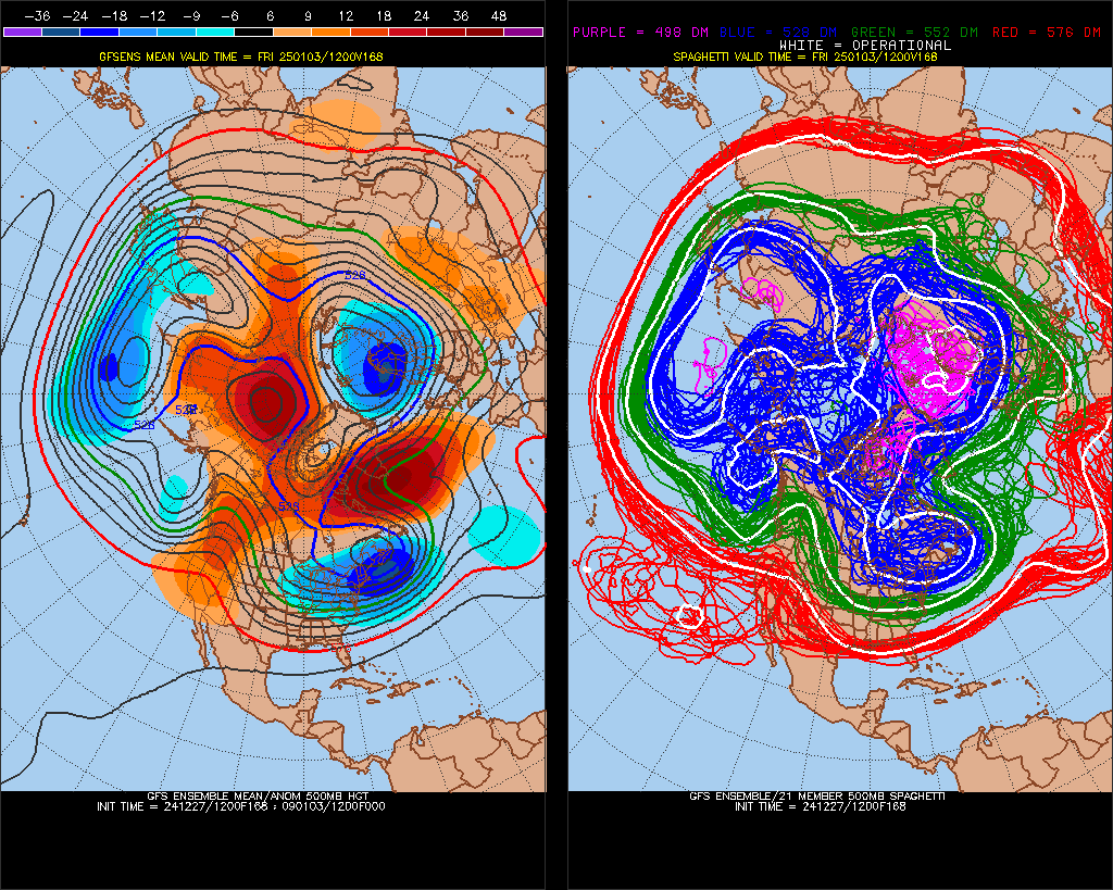
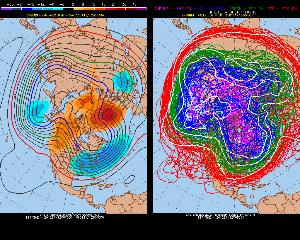
Will we see a pipe busting CAT4 cold wave as forecast by this particular GFS model run? Stay tuned.
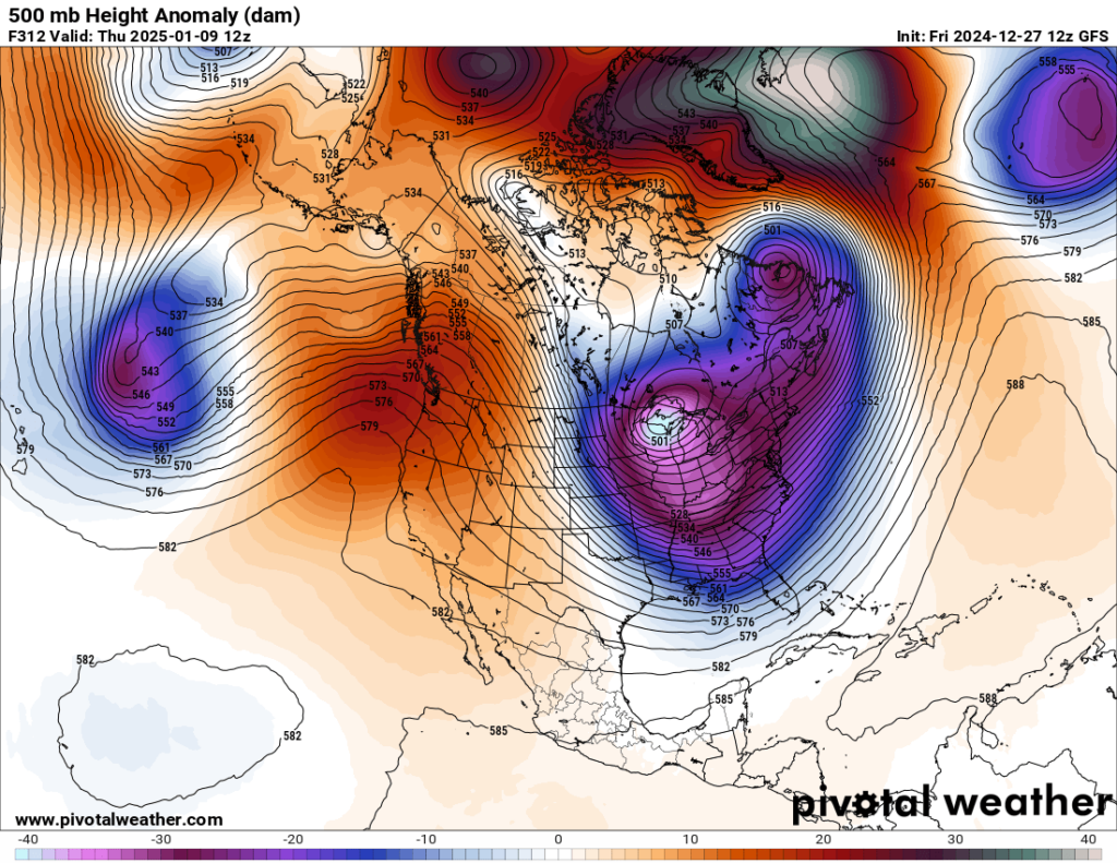
Given this type of pattern depicted from Pivotal Weather, I suspect that there would be record warmth in the West with much record chill east of the Rockies. Interestingly enough we had 108 reports of record low minimums during January 2024, so the climate is not so broken such that it can’t spit out historic record cold weather due to carbon pollution. Also, we are due to see a below average temperature month looking at my record scoreboards.
Well, where there is cold weather there is snow. Today the Washington Post took a look at both the prospects for cold weather and snow during what has been yet another mild winter, so far:
https://www.washingtonpost.com/weather/2024/12/27/winter-storm-risk-eastern-snow-forecast
Eastern U.S. bracing for the first winter storm threat of the season
January may bring the greatest potential for snow storms along the East Coast in several years.
December 27th, 2024
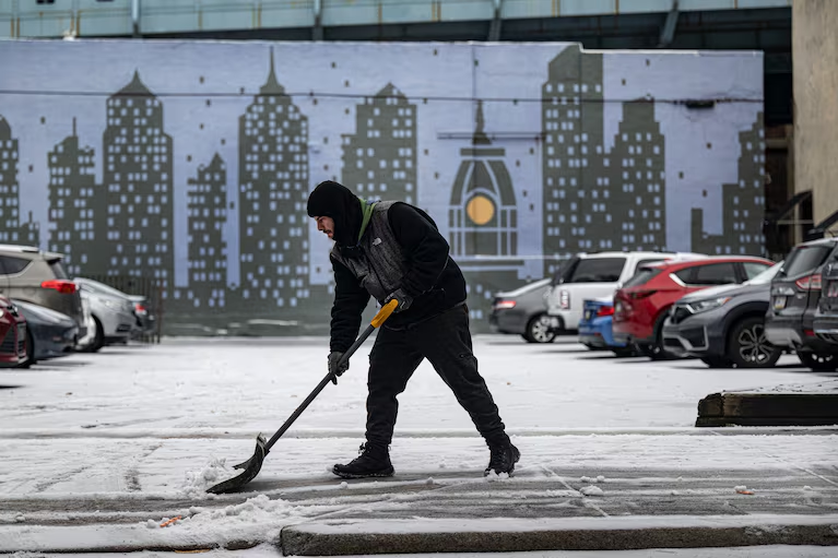
Sean Rozas shovels snow off a sidewalk in the Old City neighborhood of Philadelphia on Tuesday. (Jose F. Moreno/AP)

By Ben Noll
The East Coast has yet to experience a major storm this winter season — but meteorologists are now monitoring a potential new pattern that could drive notably stormy weather to the region come January.
Up to this point, a combination of unseasonably mild temperatures, long-term warming and atmospheric patterns more conducive to rain than snow have contributed to a milder season. For some big cities, it’s essentially been a winter storm drought.
It’s now been almost three years since New York City, Philadelphia and Boston reported a snow depth of at least six inches.
But experts say that trend could soon wane in some spots. The first chance for a storm could come between Jan. 5 and 7.
The coming pattern shift may be “by far the most favorable look we’ve had in years for moderate or even major snowstorms” for the Mid-Atlantic, meteorologist Tomer Burg said.
Forecaster John Homenuk wrote on X that he is “becoming increasingly convinced that the upcoming pattern will be the most favorable we have seen for winter weather in the Northeast US in at least a few years.”
The factors behind the snowy potential
Like any recipe, a formidable winter storm has key ingredients — requiring cold air, sufficient moisture and a suitable atmospheric pattern.
The first ingredient, cold air, will be moving into the country during early January, and it looks like it will stick around for a while.
The air mass that will drive the cold change was over Siberia as of Friday but is forecast to arrive in the United States on New Year’s Day. It will spill onto the Eastern Seaboard around Thursday and is expected to remain in place for at least a week.
The eventual location of the cold air will be key.
Frigid air centered too far east could work to suppress moisture and storm activity. This is because the dip in the jet stream — a focal point for storm formation — would be located offshore.
If the chill is located a bit farther to the west, it can enable an air mass clash along the East Coast, providing a runway for storms to develop.
It can also help to scoop up moisture from the Gulf of Mexico, another key ingredient for the most dynamic storms.
Even when the integral elements are present, a storm is not a given. In the case of the eastern storm threat, there might be enough cold air, but moisture could be a missing ingredient — at least initially.
An outlook shrouded in uncertainty
Even if the pattern during early January doesn’t produce a big storm along the East Coast, there’s another chance for stormy conditions in the middle and late part of the month.
If the jet stream dip slides westward, it could allow more moisture to travel up along the Eastern Seaboard, setting the stage for a storm.
“Outside of fast-moving clipper systems, it’s probably not until the second week of January or so that the window will open for wintry weather,” meteorologist Eric Webb said.
If the cold pattern in early January causes a snow pack to develop in the Plains and Upper Midwest, it could act as a natural refrigerator for air that ends up moving into the East — another factor that would support the eventual arrival of a big storm.
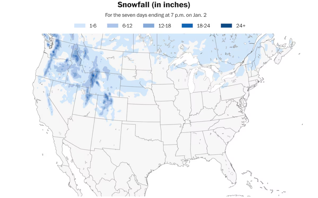
Snowfall is forecast to be sparse across the eastern states over the next week. (Ben Noll/Data source: NOAA)
It hasn’t been particularly snowy so far
As the waiting game for a snowy pattern continues, snowfall deficits continue to build.
Nationwide snowfall across the United States is 58 percent of normal as of late December.
It’s the second least snowy start to the season in at least the last 17 years — only 2023, last year, had less snow at this point.
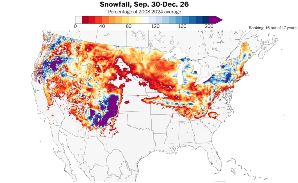
Snowfall has been well below normal across large swaths of the country so far this season. (Ben Noll/Data source: NOAA/NOHRSC)
Only the Great Lakes and interior Northeast, mountains of the Pacific Northwest and southern Rockies have been snowier than normal so far.
A colder-than-normal January boosts storm potential
When the coldest month of the year is running colder than normal, it presents a unique opportunity for vigorous storm formation.
A colder-than-normal January in the eastern United States boosts storm potential by increasing baroclinicity, a measure of the clash between cold continental air and warm ocean air.
The colder it gets, the sharper the temperature contrast, providing more energy for coastal storms, called nor’easters. This primes the atmosphere for rapid storm development, fostering stronger winter storms along the coast.
It might be a good time to dig your snow shovel out of storage, just in case.
A guide to surviving winter weather
Stay warm: If you’re going to be outside for extended periods on frigid days, it’s important to bundle up. Here are our tips for staying warm when it’s super cold — and some ideas for picking the best winter coat. Indoors, power outages can be a major issue this time of year too, so make sure you’re prepared for them.
Travel safe: Driving in snow? Here’s what to do if you get stuck in a winter storm — plus some winter essentials to keep in your car. If you’re riding a bike, here are our tips for staying safe in the dark and cold.
Prepare your home: If there’s a snow storm coming your way, here’s how to get your home ready for extreme cold. It’s also a good idea to make sure your phone and internet are ready for a disaster.

By Ben Noll Ben Noll is a meteorologist with a passion for communicating the ‘why behind the weather’, extreme events and climate trends. He has extensive experience working with meteorological data and creating weather graphics on a supercomputer, developing meteorological services in the Pacific Islands, and short, medium, and long-range weather prediction. Follow on X @BenNollWeather
Here are more “ETs” recorded from around the planet the last couple of days, their consequences, and some extreme temperature outlooks, as well as any extreme precipitation reports:
Here is More Climate News from Friday:
(As usual, this will be a fluid post in which more information gets added during the day as it crosses my radar, crediting all who have put it on-line. Items will be archived on this site for posterity. In most instances click on the pictures of each tweet to see each article. The most noteworthy items will be listed first.)