The main purpose of this ongoing blog will be to track planetary extreme, or record temperatures related to climate change. Any reports I see of ETs will be listed below the main topic of the day. I’ll refer to extreme or record temperatures as ETs (not extraterrestrials).😉
Main Topic: Why Winter Was Colder Than Average in the U.S.
Dear Diary. Last winter during the 2023/24 season the United States had its warmest winter on record, which was greatly influenced by a strong El Niño, which spiked global temps. Looking at yearly ups and downs on the following chart, it stands to reason that there would have been a dip for the subsequent 2024/25 season, all the while keeping in mind that due to climate change the trajectory is towards more warmth. Winter from 2023/24 was a true spike:
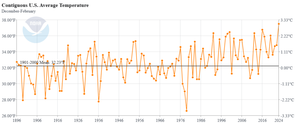
Upon close examination of this NOAA chart, one can see that usually after about 1-3 years of an upward trajectory there is a dip and vice a versa. Since the 1970s there has been a distinct upwards trajectory.
Another good reason for the lower 48 state averages this year, beyond just weather variability, is a climate changing jet stream. I’ve often mentioned Dr. Mary Francis’ work on this phenomenon. Evidently, we saw more warm surges aloft going towards the polar region, which forced many more cold outbreaks this winter compared with that of 2023/24. Unfortunately, this cold due to warming is too counterintuitive for most folks and has been laughed at by climate contrarians.
Here are more details from the Washington Post:
https://www.washingtonpost.com/weather/2025/03/03/coldest-winter-united-states-spring-forecast
Why winter was colder than average in the U.S., and what spring will bring
The United States was home to some of the planet’s most unusually cold air this season. Despite this, snowfall was generally below average.
March 3, 2025 at 6:00 a.m. EST
The United States just experienced its coldest winter in more than a decade, about 1.1 degrees below average. (Ben Noll/The Washington Post/NOAA)

By Ben Noll
Meteorological winter, which runs from December to February, ended this weekend. Not only did it give way to meteorological spring on March 1 in the Northern Hemisphere — it ended the coldest three month period in the United States since the winter of 2013 to 2014.
It was about 1.1 degrees below average as a whole in the contiguous United States, which was home to some of the most unusually cold air on the planet — a part of western Kentucky that was almost 7 degrees colder than average.
Despite the frigid temperatures, 67 percent of the country experienced below-average snowfall.
The meteorological definition for the seasons, based on historical weather statistics, differs from the astronomical definition. Astronomical spring begins on March 20.
But this next three month season will begin on a stormy, dangerous note, with severe thunderstorms and tornadoes possible in the South on Tuesday and strong winds in many regions this week, along with blizzard conditions, heavy rain and a temperature roller coaster.
An unusually cold winter
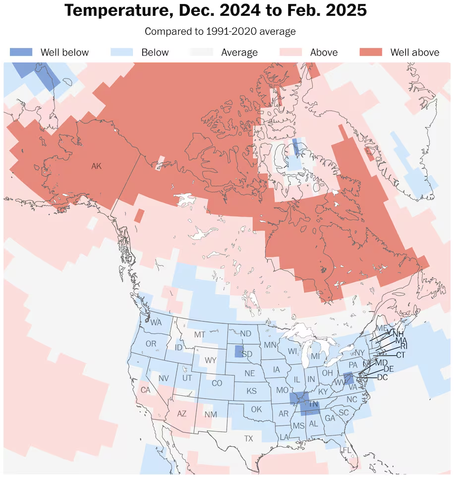
Parts of every state except Alaska and Hawaii experienced below-average temperatures this winter. (Ben Noll/The Washington Post/NOAA)
Below-average temperatures covered parts of every state except Alaska and Hawaii this winter.
The most unusually cold conditions occurred in South Dakota and in a corridor that includes Illinois, Missouri, Kentucky, Tennessee, Arkansas, Mississippi, Alabama and Georgia as well as Pennsylvania, West Virginia, Maryland and Virginia.
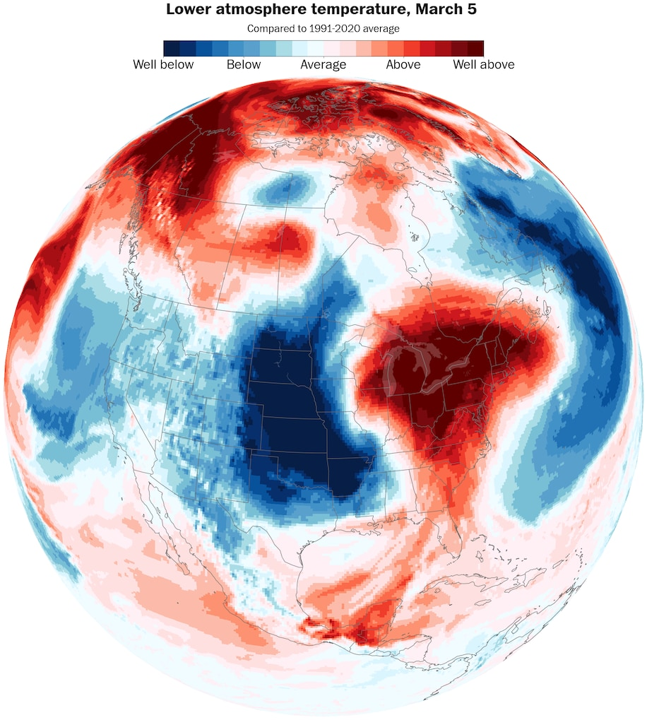
The cold conditions were driven by high pressure in the Arctic, which caused the polar vortex to be displaced unusually far south, dislodging polar air masses into the United States.
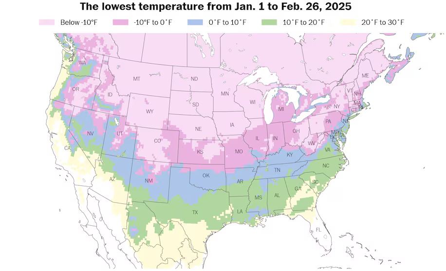
More than 111 million people across the United States have experienced subzero temperatures this year, the highest number in six years. (Ben Noll/The Washington Post/ECMWF/ERA5)
Since the start of 2025, more than 111 million people across the United States experienced subzero temperatures, the highest number in six years.
One of the true temperature oddities of the season occurred in January when Anchorage was briefly warmer than parts of Louisiana, just 30 miles inland from the Gulf of Mexico.
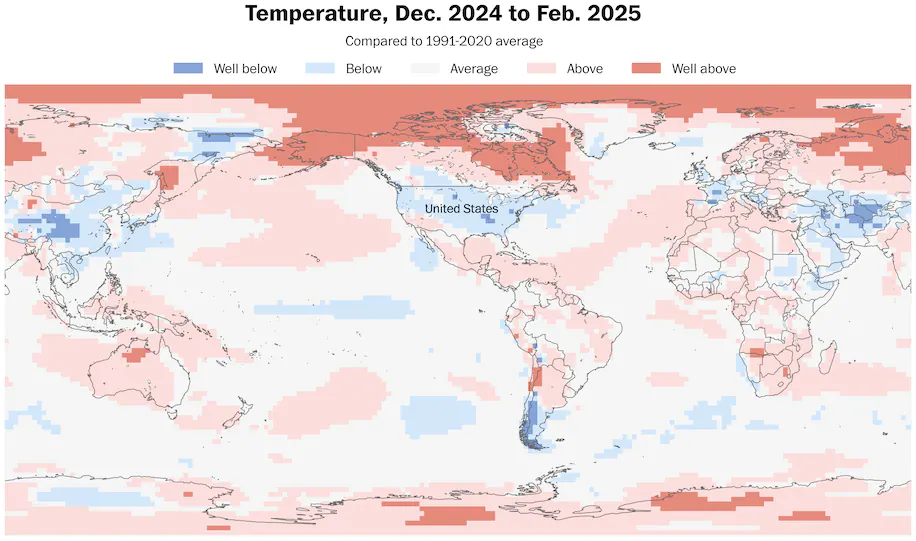
The United States was part of the 8 percent of the planet that experienced below average winter temperatures. Meanwhile, 44 percent experienced above-average temperatures. Such a ratio is consistent with a warming climate.
Below-average snowfall
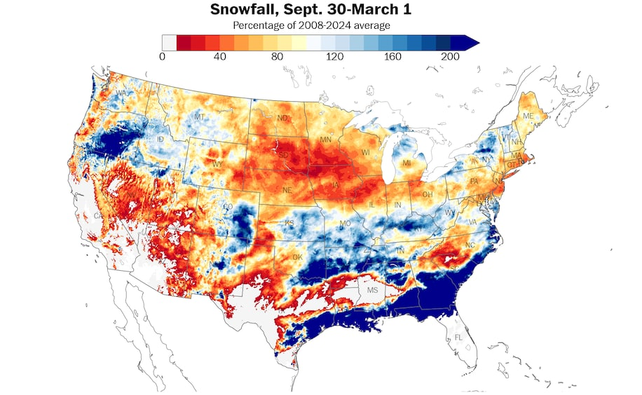
Below-average snowfall covered a majority of the United States this winter. (Ben Noll/The Washington Post/NOAA)
Despite several noteworthy winter storms, including a rare Gulf Coast snowstorm that brought a foot of snow to parts of New Orleans, snowfall was below average in 67 percent of the United States.
This is generally consistent with predictions that suggested below-average snowfall would be common this winter.
Places that experienced the greatest snowfall compared to average include eastern Texas, southern Louisiana, southern Mississippi, southern Alabama, Georgia, eastern South Carolina and eastern North Carolina as well as southeastern Oklahoma, northern Arkansas, New York’s Tug Hill Plateau and eastern Oregon.
Meanwhile, the largest snowfall deficits were found in the Dakotas, Nebraska, Iowa, Minnesota, Wisconsin, Illinois, New Jersey, Connecticut, Rhode Island, Massachusetts and western parts of the Carolinas.
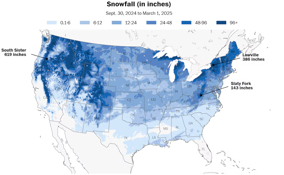
Snow fell in parts of every state this winter, with some of the heaviest totals in Oregon and New York. (Ben Noll/The Washington Post/NOAA)
The snowiest place in the western United States this season was the South Sister, a mountain west of Bend, Oregon, where a total of 619 inches fell.
In the East, the snowiest place was to the west of Lowville, New York, in the Tug Hill Plateau — where 386 inches fell. Areas near the Great Lakes were spectacularly snowy this winter because of frigid air masses crossing record warm lake water.
Parts of all 50 states experienced snow this winter.
What’s to come
Large temperature differences across the United States will fuel a dynamic storm this week. (Ben Noll/Data source: ECMWF/ERA5)
The week ahead will have severe weather, strong winds, the potential for blizzard conditions and a temperature roller coaster across the United States.
Large temperature differences will fuel a dynamic midweek storm. An atmospheric disturbance, resembling a bowling ball, will swirl across the country.

An atmospheric disturbance resembling a bowling ball will fuel severe weather across the country this week. (Ben Noll/Data source: ECMWF)
A few tornadoes may form across the South on Tuesday, with Louisiana, Arkansas and Mississippi under an enhanced risk (level 3 out of 5) from the National Weather Service Storm Prediction Center. Hail and damaging winds are expected to add to the dangerous conditions.
As the storm sweeps east, it will bring a period of heavy rain and gusty winds to many states on Wednesday. Strong winds may continue in the East through Friday, potentially resulting in sporadic power outages.
On the backside of the intense storm, blizzard conditions are possible in the Plains and Midwest from late Tuesday through Wednesday, including Kansas, Nebraska, Iowa, Minnesota, Wisconsin and Michigan. This could cause dangerous and disorienting travel conditions.
Influencing the strength of the system is a record warm patch of ocean water in the western Gulf of Mexico.
This warm water could influence a significant warm-up in the United States during the week of March 10, with meteorological spring in full swing.
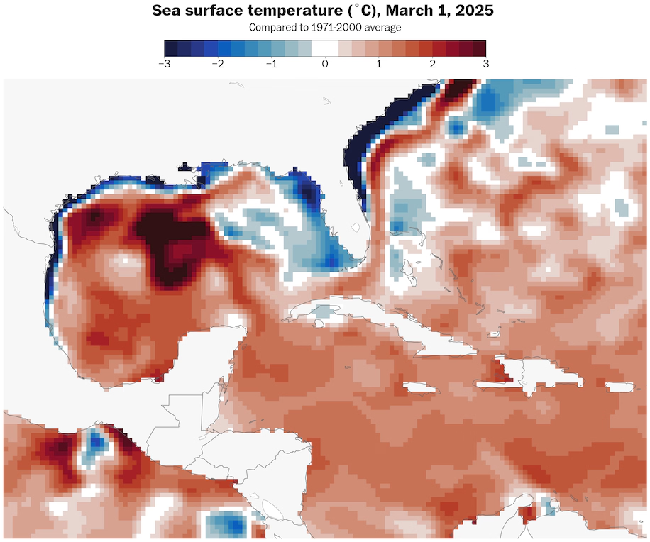
A record warm patch of ocean water in the western Gulf of Mexico will fuel severe weather and influence unusually warm conditions at times. (Ben Noll/The Washington Post/NOAA)
The statistical analysis in this piece is based upon NOAA atmospheric reanalysis data, ECMWF reanalysis data and NOAA snowfall data.
By Ben Noll Ben Noll is a meteorologist with a passion for communicating the ‘why behind the weather,’ extreme events and climate trends. He has extensive experience working with meteorological data and creating weather graphics on a supercomputer, developing meteorological services in the Pacific Islands, and short, medium and long-range weather prediction. Follow on X@BenNollWeather
Here are more “ETs” recorded from around the planet the last couple of days, their consequences, and some extreme temperature outlooks, as well as any extreme precipitation reports:
Here is more new February 2025 and Winter 2024/25 climatology (summer for Southern Hemisphere):
Here is More Climate News from Tuesday:
(As usual, this will be a fluid post in which more information gets added during the day as it crosses my radar, crediting all who have put it on-line. Items will be archived on this site for posterity. In most instances click on the pictures of each tweet to see each article. The most noteworthy items will be listed first.)