The main purpose of this ongoing blog will be to track planetary extreme, or record temperatures related to climate change. Any reports I see of ETs will be listed below the main topic of the day. I’ll refer to extreme or record temperatures as ETs (not extraterrestrials).😉
Main Topic: Heatwave Shell Peaks at a Historic CAT 4
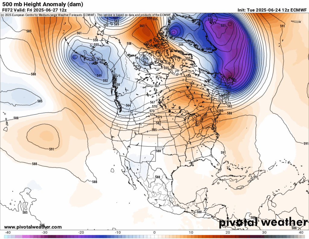
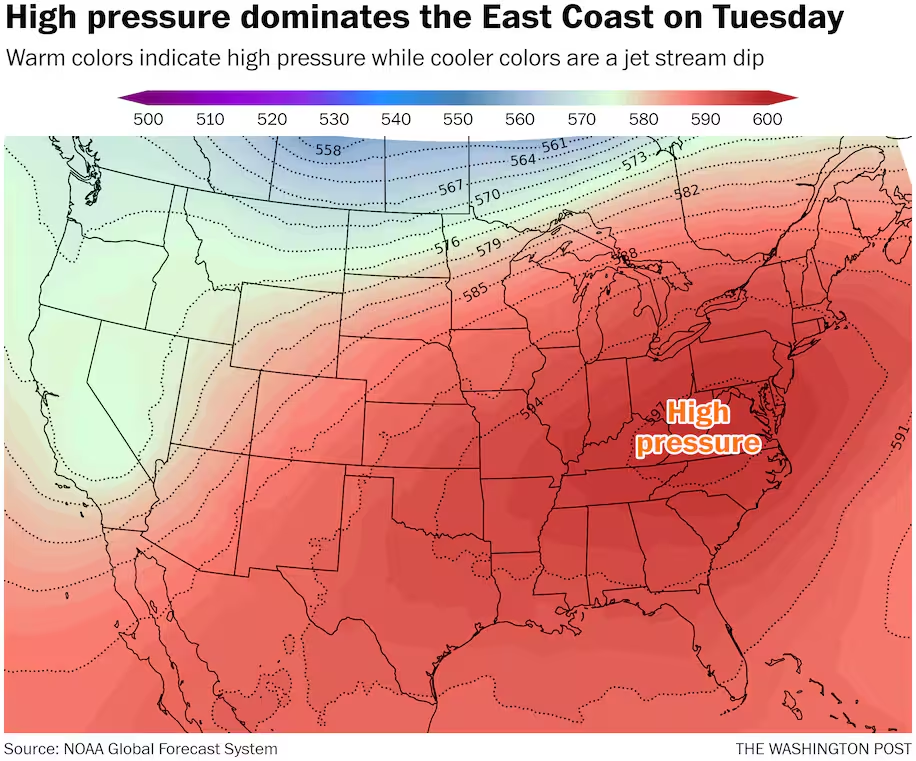
Dear Diary. As expected over the weekend, the heat dome in association with eastern Heatwave Shell verified at near 600 decameters over West Virginia on Monday:
So, why peg Heatwave Shell a historic CAT4 system at its peak using my criteria? Because many all-time record high minimums have been set from the Plains and Midwest into the Northeast. Also, the longevity of Shell over many big eastern cities makes the system a lethal heatwave with the potential to kill 500 to 1000 people. Unfortunately, the elderly and homeless are groups of people most susceptible to extreme heat…especially when it does not cool down much at night during prolonged events.
Usually heat fatality statistics trickle into the news. Heatwaves can be described as invisible killers because unlike tornadoes and hurricanes, they don’t destroy infrastructure, leaving marks for media coverage.
Here is a list of 34 all-time record high minimums from June 2025 using:
https://www.ncdc.noaa.gov/cdo-web/datatools/records
Reports from Denver eastward can be pegged on Heatwave Shell:
| HOOPESTON, IL US | 2025-06-21 | 81 | 1930-08-04 | 81 | 123 | 0 |
| ELGIN, NE US | 2025-06-21 | 78 | 2011-07-18 | 77 | 35 | 1 |
| BLUE PARK COLORADO, CO US | 2025-06-21 | 56 | 2022-06-13 | 54 | 32 | 2 |
| CHEESEMAN COLORADO, CO US | 2025-06-21 | 70 | 2022-07-18 | 69 | 38 | 1 |
| COPPER GULCH COLORADO, CO US | 2025-06-21 | 70 | 2002-06-09 | 67 | 34 | 3 |
| RIFLE COLORADO, CO US | 2025-06-21 | 74 | 1992-09-11 | 73 | 40 | 1 |
| SOUTH BRUSH CREEK, WY US | 2025-06-21 | 58 | 2000-08-10 | 58 | 36 | 0 |
| BATTLE MOUNTAIN, WY US | 2025-06-21 | 59 | 2021-07-29 | 57 | 39 | 2 |
| CROSHO, CO US | 2025-06-21 | 60 | 2002-06-08 | 59 | 38 | 1 |
| SIOUX CITY AIRPORT, IA US | 2025-06-21 | 81 | 2023-08-23 | 80 | 85 | 1 |
| LEXINGTON JIM KELLY FIELD, NE US | 2025-06-21 | 80 | 1968-08-22 | 78 | 74 | 2 |
| CHERAW 1 N, CO US | 2025-06-22 | 74 | 2025-06-21 | 73 | 31 | 1 |
| WINONA DAM 5 A, MN US | 2025-06-22 | 80 | 2006-08-01 | 80 | 85 | 0 |
| ARNOLD, NE US | 2025-06-22 | 78 | 2022-06-20 | 78 | 48 | 0 |
| BARABOO WWTP, WI US | 2025-06-22 | 79 | 1976-07-10 | 79 | 132 | 0 |
| BLOOMER, WI US | 2025-06-22 | 80 | 1996-06-29 | 79 | 80 | 1 |
| FRIENDSHIP, WI US | 2025-06-22 | 78 | 2011-07-18 | 78 | 95 | 0 |
| GAYS MILLS, WI US | 2025-06-22 | 78 | 2019-07-20 | 77 | 38 | 1 |
| LAKE GEORGE COLORADO, CO US | 2025-06-22 | 60 | 2002-06-09 | 60 | 34 | 0 |
The good news here is that the heat dome in association with Shell will rapidly come down such that by the end of the week 500 millibar heights will be at near traditional seasonable values over the East and South:
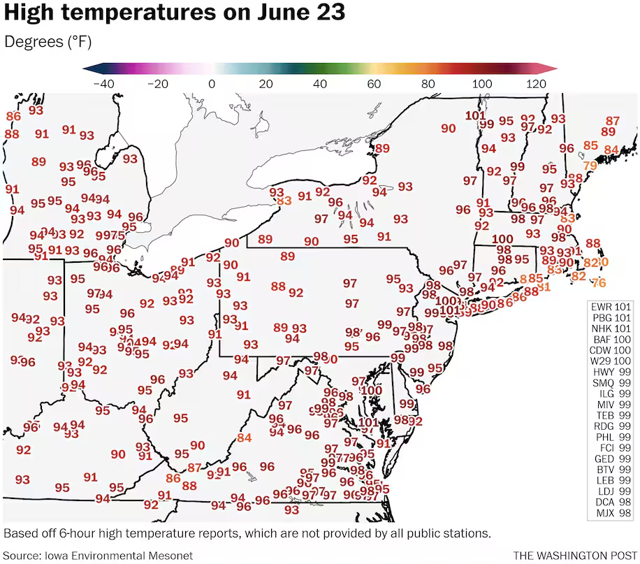
The Washington Post does a great job summarizing record statistics during and after a heatwave. Here is their latest report from today:
https://www.washingtonpost.com/weather/2025/06/24/east-coast-heat-100-degree-record-highs
As heat peaks for most of East, these cities are set to hit 100 degrees
Parts of a dozen eastern states are forecast to see temperatures of 100 degrees or higher.
June 24, 2025

A pedestrian jogs along the George Washington Memorial Parkway at sunrise in Arlington, Virginia, on Tuesday. The region’s high temperatures could hit 100 or higher. (Tom Brenner/For the Washington Post )

More than 150 million people in the eastern U.S. are under heat alerts as of early Tuesday — including about 75 million under extreme heat warnings from North Carolina to Maine.
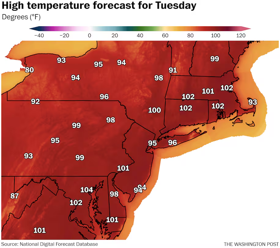
It will be the peak day of this heat wave for much of the Interstate 95 corridor, with a rather large swath of the region at risk for near or above 100-degree temperatures Tuesday afternoon.
Cities that could reach the century mark include Boston; Hartford, Connecticut; New York; Philadelphia; Baltimore; D.C.; and Raleigh, North Carolina. Portions of a dozen eastern states are forecast to see temperatures of 100 or higher.
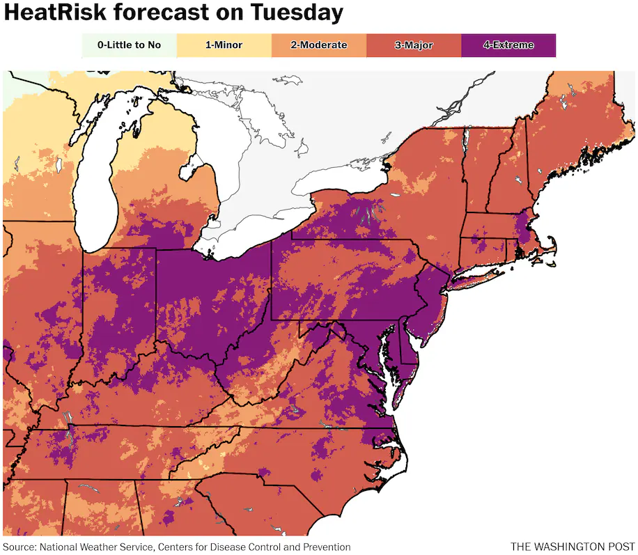
Highs should be a bit warmer than Monday’s in most locations in the mid-Atlantic and Northeast, while they’ll be a little lower over the Ohio Valley. Extreme HeatRisk will be widespread across all of these regions, with a focus from Indiana and Ohio to the coastal Mid-Atlantic.
Among the hottest spots on Monday afternoon was Newark, where it reached 101 degrees. Highs of 100-plus also made it all the way to northern New York as high humidity swamped the region.
Where it doesn’t hit 100 in this stretch, it’ll be close and will feel like it got there. Numerous records are probable again Tuesday, after dozens were set Monday. Similar conditions are expected Wednesday before the heat wave begins to abate.
Where the highest heat is headed
Many locations should approach or surpass 100 on Tuesday afternoon.
The focus of the most intense heat is along the I-95 corridor. The day could offer some truly astounding temperatures for locations that rarely see it get so hot, such as coastal Massachusetts.

From north to south, here are selected forecast highs for Tuesday, and the current record for the date:
- Boston: 102 (record of 95 in 2013)
- Hartford, Connecticut: 101 (record of 94 in 2013)
- New York: 99 in Central Park (record of 96 in 1888)
- Philadelphia: 101 (record of 99 in 1923)
- D.C.: 101 (record of 100 in 2010)
- Raleigh, North Carolina: 103 (record of 99 in 2010)
- Charlotte: 100 (record of 102 in 1930)
- Atlanta: 100 (record of 99 in 1988)
If the forecast is realized, Tuesday will be the hottest day on record for June in Hartford. In Boston, a high of 102 would also set the record for hottest day in June and become one of the hottest days in any month. Philadelphia’s record for June is 102, which could be tied if temperatures there overperform the forecast.
When factoring in the high humidity, thanks to stifling dew points at or above 70, heat index values will rise about 10 degrees higher than the actual temperature. That equates to widespread apparent temperatures of 105 to 115 during the afternoon from Florida to Maine and across parts of the Ohio and Tennessee valleys.
It’s also some of the hottest weather in the country. Only a couple locations in the Desert Southwest will be as hot or hotter, and with lower humidity.
No escape from scorching temperatures
Potential record highs ranging from the mid- to upper 90s will surround the hottest locations on Tuesday.
Even in the high country of the Appalachians, there won’t be much escape. Mountainous locations in West Virginia through North Carolina should mainly reach the low and mid-90s.
In Vermont, a high temperature of 97 is forecast for Burlington in the far north of the state. On Monday, it hit a record 99 there while dew points rose to near 80 — basically unheard of in the region.
In addition to the dozens of record highs, more than 100 warm record lows were set early Tuesday, as long as they hold through the whole day.
Temperatures remained in the 70s to above 80 across most of the same zones. A lack of overnight cooling is a stark signal of human-caused climate change and can quickly make heat waves more dangerous since it removes the opportunity for the body to easily cool while at rest.
Parts of the country that have already seen extreme heat
Over the past week, much of the country has witnessed their hottest temperatures of the year so far. The heat ramped up in the intermountain west late last week before shifting eastward.
On Monday, Plattsburgh in far northern New York and Lebanon in New Hampshire both tied their all-time highs for any month with 101 and 98, respectively.
Newark, just outside New York City in northern New Jersey, reached 101 on Monday, a record for the date. The cities of Westfield, Massachusetts, and Raleigh, North Carolina, are among the handful of additional locations that reached 100.
This follows 100-degree readings as far north as South Dakota, Minnesota and the northern Ohio Valley during this country-crossing heat wave.
More heat coming Wednesday
The most intense heat will get squashed farther to the south and east Wednesday. Record high potential should focus from around New Jersey south to the Carolinas.
The footprint of 100s should shrink considerably compared to Tuesday, but a corridor of 100-plus could focus on eastern North Carolina to southeast Virginia, with the potential for a smattering of century marks elsewhere.
Philadelphia and Washington should see highs in the mid-90s to around 100, which could set some additional regional daily high-temperature records.
By Ian Livingston Ian Livingston is a forecaster/photographer and information lead for the Capital Weather Gang. By day, Ian is a defense and national security researcher at a D.C. think tank.
Here are more “ET’s” recorded from around the planet the last couple of days, their consequences, and some extreme temperature outlooks, as well as any extreme precipitation reports:
Here is More Climate News from Tuesday:
(As usual, this will be a fluid post in which more information gets added during the day as it crosses my radar, crediting all who have put it on-line. Items will be archived on this site for posterity. In most instances click on the pictures of each tweet to see each article. The most noteworthy items will be listed first.)