The main purpose of this ongoing blog will be to track planetary extreme, or record temperatures related to climate change. Any reports I see of ETs will be listed below the main topic of the day. I’ll refer to extreme or record temperatures as ETs (not extraterrestrials).😜
Main Topic: A Needed Break from the Tropics
Dear Diary. The United States is very stressed on this 24th anniversary of 911. Charlie Kirk, a prominent conservative politician, was assassinated yesterday. Political violence is ramping back up to 1960s levels. Fascism is taking over due to Trump and his cronies. Science itself is under siege. And FEMA, the Federal Emergency Management Agency us underfunded, under manned, and of course stressed.
September 10th is the typical climatological midpoint for the tropical season. Usually by this point there have been one or two hurricane landfalls in the U.S. Thankfully this year there have been none so far. In fact, we are in the second long hurricane drought in recent years. Is that too a sign of climate change or just Trump and the United States’ good fortune?
I haven’t presented my climate change tropical what to look for list in many moons:
Here are attributable climate change factors researchers are looking with any tropical cyclone:
1) Record strength per relatively high latitude (For example, if Florence had moved near Wilmington, NC or further north as a cat 4 this would have been the farthest north a cat 4 or higher system had made landfall in the U.S.)
2) Record or near record low pressure and corresponding record high sustained wind speed (Wilma from 2005 holds that record over the Atlantic Basin at 882 millibars.)
3) Longevity of maintaining a relatively high wind speed. (Irma set some records for this over the central Atlantic in 2017.)
4) Record rainfall after landfall (Harvey set many records for totals in 2017.)
5) Stalling, becoming trapped underneath a warm ridge either before or after landfall. (Harvey was the poster child for this effect.)
6) Record or near record rapid intensification
7) Record late or early season tropical cyclones for any given ocean basin
8) Record length of time a tropical system is able to maintain depression status or higher once moving inland
9) Forming over “odd” locations of an ocean basin not traditionally seeing tropical development
10) Seeing numerous simultaneous systems over the world’s oceans
Do we need to add number 11) Prolonged hurricane droughts because marine heat waves are leading to more wind shear and less disturbances across tropical development areas?
One other thing to keep in mind is if tropical development becomes more limited due to AGW, then there will be less of a mechanism that turns excess heat into kinetic energy, so we might have another detrimental feedback mechanism in the works leading to faster warming…although this would pale in comparison to such items as sea ice reduction.
Here are more details from Dr. Jeff Masters:
Another round of weird peak-season quiet in the Atlantic tropics » Yale Climate Connections
Another round of weird peak-season quiet in the Atlantic tropics
Resilient Hurricane Kiko finally weakens as it brushes Hawaii to the north.


by Bob Henson and Jeff Masters
September 8, 2025
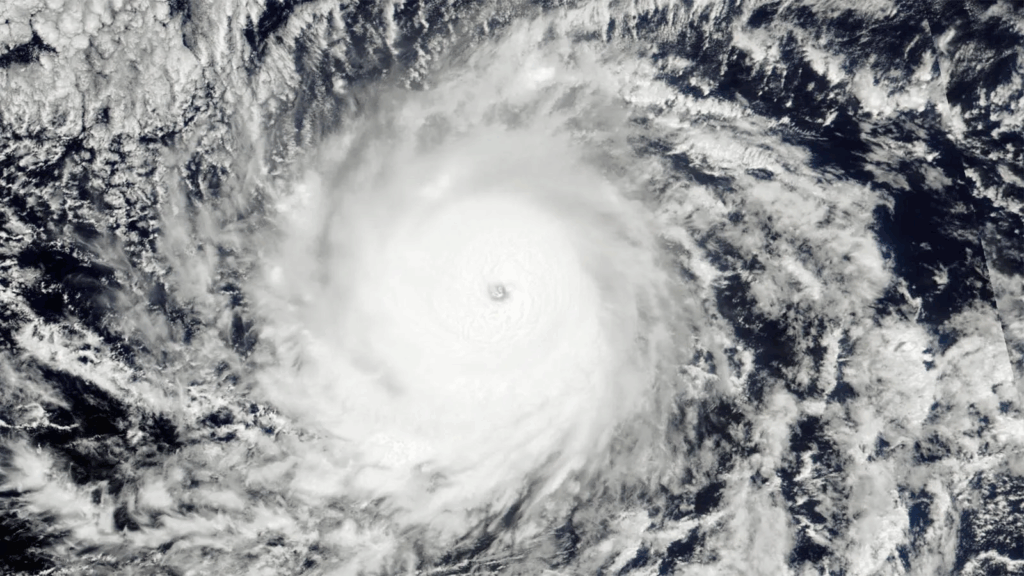
Hurricane Kiko on September 4, 2025, when it was at peak intensity as a Category 4 storm with 145 mph winds. (Image credit: NASA Worldview)
We’ve arrived at the peak week of hurricane season – the traditional midpoint of the Atlantic’s yearly activity is September 10 – but you wouldn’t know it from the Tropical Weather Outlook issued by the National Hurricane Center, or NHC, on Monday, September 8. The headline: “Tropical cyclone activity is not expected during the next 7 days.”
As we reported last Thursday, September 4, NHC had given a disturbance in the eastern tropical Atlantic known as Invest 91L an 80% chance of developing over the subsequent week and upped the odds to 90% on Friday morning. But 91L was never able to fully organize, and by early Sunday, it was no longer being tracked by NHC. There’s no obvious single factor that did in 91L, though an unexpectedly stable atmosphere in the deep Atlantic tropics may be part of the mix.
Michael Lowry has an excellent discussion on why 91L may have faltered and how Google’s DeepMind AI model did the best job on the system.
With the demise of Tropical Storm Fernand August 28, it’s now been 11 days since any named storms have prowled the Atlantic. It’s not that unusual to get a one- or two-week pause in the Atlantic hurricane season, although it’s a bit more uncommon for things to go quiet for too long when we’re this close to the climatological peak.
Just last year, there was a 20-day break between August 20, when Hurricane Ernesto was declared post-tropical, and the emergence of soon-to-be Hurricane Francine as a tropical storm on September 9. The interval without any named-storm formation ran from August 13 to September 8 – the first time since 1968 that this particular 27-day period had seen no named storms develop. As of Monday, we’ve racked up a string of 16 days free of named-storm formation in the Atlantic, and if the NHC’s current outlook verifies, that will extend to 23 days by next Monday.
One striking aspect of these peak-season pauses: They’ve both occurred despite the widespread extent of unusually warm to record-warm sea surface temperatures.
Meteorologist Eric Webb mused on the pause last year in this tweet of September 3, 2024:
This Atlantic Hurricane Season is teaching &/or reminding folks (including myself to a degree) that we are hyper fixated on/overweighting local, tropical [sea surface temperature anomalies] for seasonal forecasting. This season also could be offering us a glimpse into what future hurricane seasons may potentially look like.
Owing mainly to the strength and duration of former Category 5 Hurricane Erin, which nimbly avoided any landfalls, the Atlantic is only running about 20% below the average accumulated cyclone energy, or ACE, for this point in the season, according to statistics updated daily by Colorado State University. But Erin is the only hurricane among the season’s six named Atlantic systems thus far. Based on a 1991-2020 climatology, the average dates of formation of the third and fourth Atlantic hurricanes each year are September 7 and 16.
The chasm in strength between former Category 5 Erin and this year’s other Atlantic systems is vast. Erin, which revved up top sustained winds of 160 mph, is the Atlantic’s only system this year to pack top winds of at least 65 mph.
Looking ahead in the Atlantic
In its biweekly outlook issued September 3 for the period September 3-16, the forecast team at Colorado State University led by Phil Klotzbach called for a 65% chance of near-normal activity. The next week or two will see a partial reversal of the upper-level pattern that’s favored deep upper troughs in the eastern half of the United States and ridging in the west, with that pattern gradually morphing toward more of a western trough and eastern-U.S./western-Atlantic ridge. Such a pattern could favor a higher chance of a U.S. landfall if any system(s) take shape – a very big “if” at this point.
The operational GFS model has been consistently suggesting a system might move northward from the Western Caribbean into the Gulf of Mexico late next week, and a few GEFS ensemble members have also shown unsettledness toward the Bay of Campeche and western Gulf later next week, but this is far beyond a reliable forecast window. The GEFS also suggests recurvature is the most likely fate of any development further east. The European ensemble model is distinctly less bullish about overall activity next week, including any potential Gulf system.
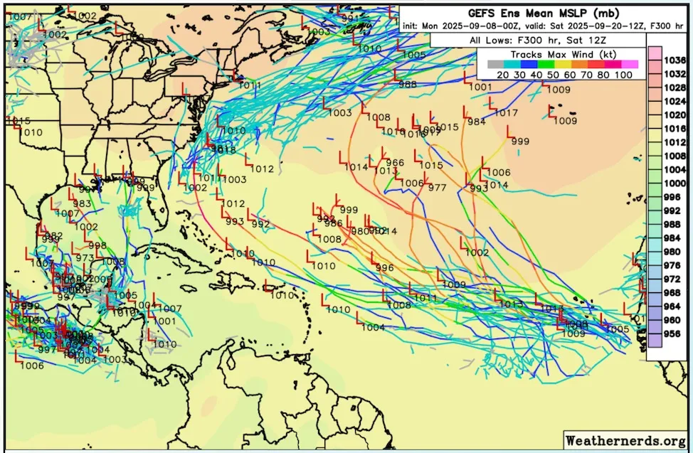
Figure 1. Ensemble member tracks from the GEFS model out to September 20 from a starting point of 0Z Monday, Sept. 8 (8 p.m. EDT Sunday). Image credit: weathernerds.org.
Kiko expected to stay safely north of Hawaii
Hurricane Kiko’s multiple bursts of intensity have kept forecasters on their toes, but the storm’s very predictable track is good news for Hawaii. Now a weakening Category 1 hurricane with top winds of 85 mph (140 km/h) as of 11 a.m. EDT Monday, Kiko is continuing to move steadily west-northwest at 15 mph (24 km/h). Update: As of 11 p.m. EDT Tuesday, Kiko was located about 150 miles northeast of Honolulu, moving west-northwest at 14 mph. Top sustained winds were down to minimal tropical-storm strength, 40 mph (65 km/h), and these were located mainly on the north side of the storm, away from Hawaii. Honolulu’s sustained winds at the time were only 14 mph (23 km/h). Kiko was declared a post-tropical remnant low at 11 a.m. EDT Wednesday.
Kiko is projected to pass around 150-250 miles (240-400 km) north of the Hawaiian Islands on Tuesday and Wednesday as a weakening tropical storm. Sustained tropical-storm-force winds aren’t predicted to reach as far south as the islands, especially since Hawaii lies on the weaker side of Kiko, but several days of big swells and life-threatening rip currents can be expected. No rainfall impacts from Kiko are being predicted by NHC for the Hawaiian Islands.
Kiko’s top winds peaked in the Category 4 range twice: 145 mph late Wednesday, September 3, and 140 mph late Friday, September 5. There was a dip to minimal Cat 3 strength (115 mph) in between as dry air infiltrated and temporarily weakened Kiko.
New storm possible this weekend in the Eastern Pacific off the coast of Mexico
For the Eastern Pacific waters off the coast of Mexico, NHC is predicting that the next named storm could occur this weekend or early next week. Recent runs of the GFS and European model have been predicting that a tropical wave will develop then and move west-northwest, parallel to the coast of Mexico. In their 8 a.m. EDT Monday Tropical Weather Outlook, NHC gave two-day and seven-day odds of development of 0% and 30% to this future system. The next name on the Eastern Pacific list of storms is Mario.
MORE LIKE THIS

August 2025: Earth’s 3rd-hottest August on record

‘Flash droughts’: How climate change increases the risk of these short-lived but devastating events

When wildfire hit her street, even a climate expert felt unprepared
Bob Henson
Bob Henson is a meteorologist and journalist based in Boulder, Colorado. He has written on weather and climate for the National Center for Atmospheric Research, Weather Underground, and many freelance… More by Bob Henson
Jeff Masters
Jeff Masters, Ph.D., worked as a hurricane scientist with the NOAA Hurricane Hunters from 1986-1990. After a near-fatal flight into category 5 Hurricane Hugo, he left the Hurricane Hunters to pursue a… More by Jeff Masters
Jeff Master’s and Bob Henson’s “Another round of weird peak-season quiet in the Atlantic tropics” was first published on Yale Climate Connections, a program of the Yale School of the Environment, available at: http://yaleclimateconnections.org. This work is licensed under a Creative Commons Attribution-Noncommercial-No Derivative Works 2.5 license (CC BY-NC-ND 2.5).
Here are more “ETs” recorded from around the planet the last couple of days, their consequences, and some extreme temperature outlooks, as well as any extreme precipitation reports:
Here is More Climate News from Thursday:
(As usual, this will be a fluid post in which more information gets added during the day as it crosses my radar, crediting all who have put it on-line. Items will be archived on this site for posterity. In most instances click on the pictures of each tweet to see each article. The most noteworthy items will be listed first.)