The main purpose of this ongoing blog will be to track global extreme or record temperatures related to climate change. Any reports I see of ETs will be listed below the main topic of the day. I’ll refer to extreme or record temperatures as ETs (not extraterrestrials).😜
Main Topic: Winter Storm Fern’s Cold Wave Aftermath
Dear Diary. On Saturday the 24th I let all reading this blog know that a big storm and associated storm was in the works, which was being influenced by climate change:
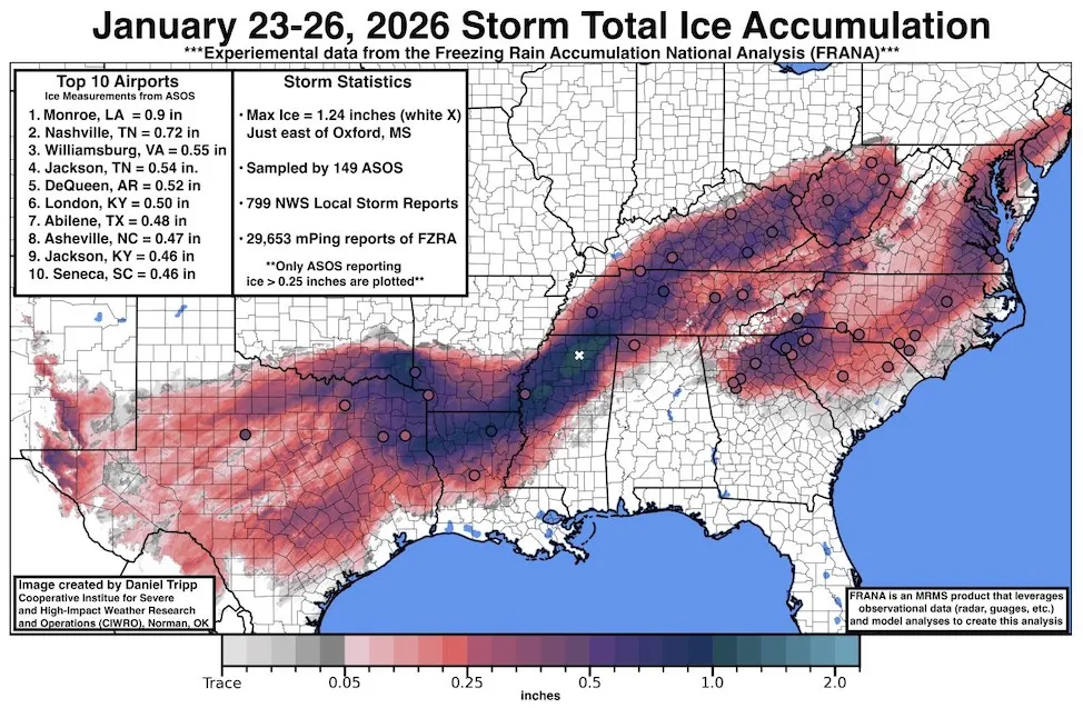
Today we will concentrate on its aftermath. Personally, I only saw a light icing event where I live in Atlanta with the temperature getting down to 31°F, so I never lost power. Folks from the northeast side of the city and points north and east in the typical “wedge” cold air damming zone weren’t as lucky. Also, millions of people lost power from Texas through Northern Mississippi into Tennessee and through the mid-Atlantic area. As of this writing thousands still are waiting for power to come back on as they shiver in temperatures in the teens and twenties at night all this week.
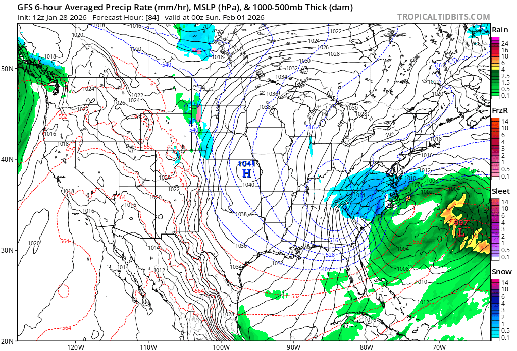
Another cold wave and associated storm will keep people in the deep freeze this weekend:
I expect only a light dusting of snow around Atlanta, but hefty snow totals are possible in the Carolinas into the mid-Atlantic area. It is still too early to peg how much snow the big coastal cities of the Northeast might see out of this storm system. Thankfully, next week looks much warmer.
Here is a recent article from the Washington Post indicating how bad Fern was:
Deep cold could last days, worsening storm’s impacts – The Washington Post
Deep cold could last days, worsening storm’s impacts: ‘I’m just really, really tired’
Cold weather alerts were in effect for about 210 million people early Monday as forecasters monitor another potential storm.
Updated January 26, 2026
A massive winter storm hit the East Coast on Jan. 25, bringing debilitating snow and ice to millions of Americans. (Video: The Washington Post)
By Matthew Cappucci, Ruby Mellen, Ben Noll and Brady Dennis
GRENADA, Miss. — Ice-covered roads in the Southeast glistened early Monday, the sun poking out and the frosty landscape bright and sparkling. But after freezing rain pelted this area for much of the weekend, and with surface temperatures hovering in the high 20s, the icy remains were markers of storm hazards far from over.
A massive winter storm that blanketed about 220 million people across the United States with heavy snow, crippling ice and widespread power outages cleared by early Monday but left behind a bone-deep chill. Dangerous and record-breaking cold temperatures have settled in. The impact of the cold will be amplified by how long it will last. In many areas — including the nation’s capital — temperatures may not rise above freezing until early February, part of a streak that started in D.C. on Friday evening.
At least 19 people have died since the storm began, The Washington Post confirmed, fatalities stretching from Texas to New York both as the storm hammered communities and in the immediate aftermath. Hundreds of thousands remain without power. And forecasters are closely watching the potential for another storm this weekend, as local officials assess the storm’s wreckage.
“I don’t think any of us could have prepared for what we got. It has just been catastrophic,” Robyn Tannehill, the mayor of hard-hit Oxford, Mississippi, said in an interview Monday afternoon. “It literally looks like a tornado has gone down every street in our community.”
She described scenes of destruction, mostly from towering oak trees that had surrendered under the weight of ice and fallen on houses, cars, streets and power lines. When she was finally able to survey the damage, “I just cried,” Tannehill said. “This is going to leave a lasting impact on our community.”
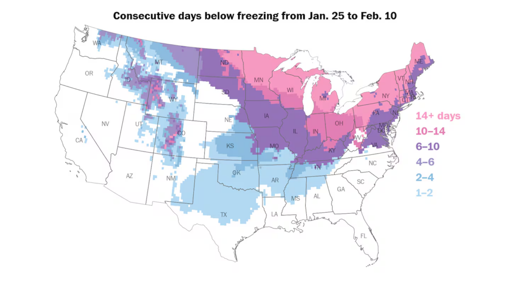
Across the northern U.S., freezing temperatures could last for a week straight or longer, according to NOAA/GFS forecasts. (Ben Noll/The Washington Post)
The prolonged frigid temperatures could hamstring efforts to get power back to more than 600,000 customers experiencing outages across the country as of Monday afternoon. Those outages appeared mostly on the local level, rather than affecting widespread grids, analysts said.
Heavy ice can weigh down power lines or break tree branches that can wreck infrastructure. And frigid temperatures mean power companies hoping to do repairs will continue to face slick conditions on the roads. Even as power crews restore electricity in some spots, Tannehill said, tree limbs have continued to fall and knock out power again.
Outages occurred mainly across the South, affecting more than 200,000 customers in Tennessee — where the brunt of the outages were focused — more than 100,000 in both Mississippi and Louisiana, and tens of thousands of customers in Texas, Kentucky, South Carolina, Georgia and Virginia.
“We are making progress despite difficult conditions for workers, including fallen trees, deep snow, icy roads and frigid temperatures,” said Scott Brooks, the spokesperson for Tennessee Valley Authority, a federally owned electric utility corporation that covers all of Tennessee — which is facing the most outages nationwide.
Brooks said crews were on the ground and in the air assessing damage and restoring lines with all available resources, including bucket trucks, dozers, track equipment, skid steers, UTVs and chainsaw crews on the ground, with helicopters and drones overhead.
Nashville saw some of the most concentrated outages in the country.
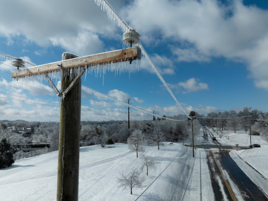
Ice accumulated on utility lines Monday in Nashville. (Brett Carlsen/Getty Images)
Mayor Freddie O’Connell said at a news conference Monday that while power had been restored to roughly 50,000 customers in the area, about 175,000 remained without electricity — a huge worry as frigid temperatures persist.
O’Connell said officials had nearly doubled the number of crews working to get power up and running again and had contracted with additional workers to help with removing downed trees. But even so, a monumental task remains, and fully restoring power could take days.
The uncertainty has pushed some residents out of their homes, seeking warmer shelters.
Mike Purcell woke up Monday and saw the thermostat in his East Nashville home, which lost power the day before, was at 44 degrees. He had slept under four layers of blankets and tried to further insulate his windows, but the prospect of a few more days without heat pushed the 53-year-old audio engineer to pack up some clothes, his three cats and check into a hotel.
“God, this ice is just terrible,” Purcell said. Over the weekend as he was chipping a frozen glaze off his car, he heard a deafening crack and watched as a nearby branch broke off and smashed his neighbor’s vehicle.
Now warmer inside a downtown hotel room, the uncertainty of when he’ll be able to move back home is weighing on him — and the cats, two of whom were in hiding under the bathroom cabinet, suspicious of their new surroundings.
“I’m just really, really tired,” he said.
For those unable to find other places to stay, O’Connell and other local officials urged anyone without power to seek out one of the many warming centers that remain open in the area.
O’Connell said the local government planned Monday to activate a call line for anyone who needed help to do so. “We know not everyone can drive, and we don’t want transportation to be a barrier to getting to someplace warm if your power is out,” he said.
The cold temperatures forecast could also mean a second form of outages as demand strains grids to their limits, said Alex Shattuck, director of grid transformation at the Energy Systems Integration Group.
PJM, the United States’ biggest grid operator that serves more than 67 million people across the country, said its demand could peak to more than 130,000 megawatts for seven consecutive days. That would mark “a winter streak that PJM has never experienced,” the company said in a statement.
“They may run into a similar issue that we saw in Texas,” Shattuck said, referring to a grid failure that plagued the state in 2021 amid freezing temperatures that left millions without power for days.

A woman walks in New York City during the storm on Sunday. (Andres Kudacki/Getty Images)
Cold weather alerts were in effect as of early Monday for about 210 million people across the U.S., with locations across the Midwest and Plains breaking daily low temperature records.
“Frostbite and hypothermia will occur if unprotected skin is exposed to these temperatures. An extended period of freezing temperatures could cause ruptured water pipes,” wrote the National Weather Service office in Jackson, Mississippi, which serves areas of the state that were most affected by the ice storm.
In one sign of how strained local resources have become because of the storm, O’Connell said that metro Nashville’s 911 center continues to experience “very high call volumes, which is causing some delays in answering.”
“If you are experiencing an emergency, please do not hang up,” the mayor said. “Someone will be with you as soon as they can.”
As of 6 a.m. Monday, these low temperatures were recorded:
- Minneapolis: minus-12 degrees.
- Springfield, Missouri: minus-7 degrees.
- Tulsa: 1 degree.
- Dallas: 15 degrees.
- Austin and San Antonio: 20 degrees.
- Houston: 24 degrees.
- Shreveport, Louisiana: 21 degrees.
- Tupelo, Mississippi: 16 degrees.
- Nashville: 14 degrees.
Throughout the week, record low temperatures are possible in 24 states and D.C., with some places forecast to break records that have stood for more than a century — most notably in Texas, Louisiana and Tennessee.
Across the Midwest and Northeast, fresh snow will make the deep freeze worse by causing temperatures to drop lower at night and reflect sunlight during the day. The cold will also be exacerbated by gusty winds throughout the week.
It seems the cold could turn less intense in early February, but conditions aren’t forecast to turn significantly milder any time soon.
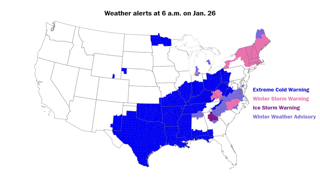
Winter weather alerts covered swaths of the United States early Monday as the storm pulled away. (Ben Noll/The Washington Post)
Forecasters monitor a chance for more storms
Forecasters are closely monitoring the potential for another storm near the East Coast this weekend.
While it’s too early to tell whether there will be major weather impacts, several reliable computer models early Monday shifted in a stormier direction, indicating that a weekend storm was possible.
Although this frigid weather pattern is ripe for snow, the weekend storm depends on a swirling disturbance near Hudson Bay in Canada looping southward and stalling near the East Coast — a complex weather setup that will cause forecasts to fluctuate.
If another storm forms, eastern areas that were hit hard by snow and ice over the weekend could get much more, though in that case, the cold temperatures could be a boon.
“It’s counterintuitive, but colder temperatures can be better because you get sleet and snow instead of straight ice,” Shattuck says. “If it stays to mostly snow, we should see significantly less impact as we saw locally from the ice storm.”
Mellen reported from Washington; Noll from Auckland, New Zealand; and Dennis from Durham, North Carolina.
Much more:
Here are some “ETs” recorded from around the planet the last couple of days, their consequences, and some extreme temperature outlooks, as well as any extreme precipitation reports:
Here is More Climate News from Wednesday:
(As usual, this will be a fluid post in which more information gets added during the day as it crosses my radar, crediting all who have put it on-line. Items will be archived on this site for posterity. In most instances click on the pictures of each tweet to see each article. The most noteworthy items will be listed first.)