The main purpose of this ongoing blog will be to track global extreme or record temperatures related to climate change. Any reports I see of ETs will be listed below the main topic of the day. I’ll refer to extreme or record temperatures as ETs (not extraterrestrials).😜
Main Topic: Winter Storm and Cold Wave Gianna Shiver the Southeast
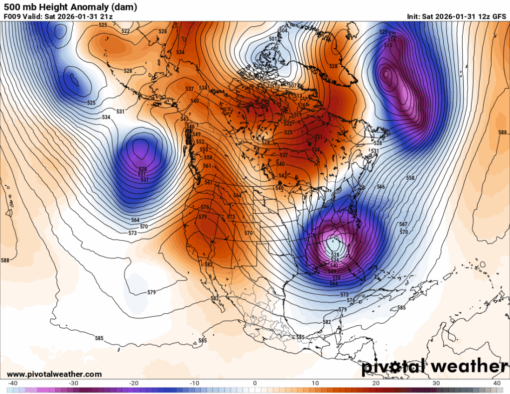
Dear Diary. This weekend one of the coldest pieces of the polar vortex I have ever seen got squeezed into the Southeast with its center over my home state of Georgia:
Where I live, we only saw a dusting of snow from what the Weather Channel has dubbed Gianna, but just to my east by about thirty miles several inches were noted with amounts going up to a foot in the Carolinas. The Outer Banks of North Carolina will experience a very rare true blizzard from Gianna tonight. Fortunately for the Northeast, Gianna will move out to sea.
Here on the Extreme Temperature Diary, we name Cold and Heatwaves if they become “major.” We also rank them on a scale of 1-5. A major system would have a ranking of 3 and above. Giana has a major cold outbreak in association with the storm and is pegged as a CAT3 because dozens of record cold reports will be caused by the system, particularly in Florida.
Here are more details from the Washington Post:
Strong nor’easter will bring blizzard conditions, flooding and deep cold – The Washington Post
The Southeast is bracing for a bomb cyclone. What to expect this weekend.
This intense storm will bring moderate-to-major impacts to about 35 million people in the East and extreme cold to millions more this weekend.
January 31, 2026
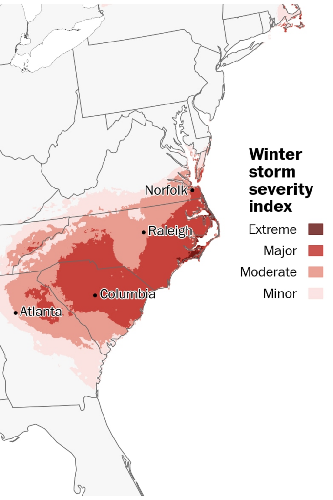
About 35 million people can expect moderate-to-major winter storm impacts from the powerful nor’easter, with about 140 thousand more seeing extreme impacts. (Ben Noll/The Washington Post)
By Ben Noll, Brady Dennis and Ruby Mellen
Parts of the Southeast and Eastern Seaboard are bracing for a powerful storm this weekend that will bring blizzard conditions and deep cold to coastal stretches of the region.
An intense nor’easter has already brought several inches of snow to the southern Appalachians on Saturday and is expected to become a dangerous bomb cyclone off the coast of North Carolina by Sunday morning. The storm will rapidly intensify Saturday night, strengthening at more than twice the rate needed to classify as meteorological bombogenesis. The worst of the storm is expected to hit the Carolinas and southern Mid Atlantic coast, but the storm will also usher frigid temperatures across a broad swath that includes areas still recovering from last weekend’s widespread tempest that left at least 69 people dead.
In North Carolina’s storm-weary Outer Banks, moderate-to-significant coastal flooding is expected, especially during high tides on Saturday evening and Sunday morning. Strong winds and moderate to heavy snow will make for blizzard conditions Saturday night.
And as a lobe of the polar vortex swirls south late Saturday into Sunday, not even Florida will be spared. The Sunshine State is bracing for the potential for rare and highly unusual Gulf of Mexico-effect snow. There’s a chance Tampa will its greatest snowfall on record.
The storm will also scrape the coastal Mid-Atlantic and southeast Massachusetts from late Saturday to Monday while en route to Nova Scotia and Newfoundland in Canada, where it will deliver significant snow into next week.
In the southern Appalachians and Carolinas, where storm’s heaviest snow is expected, more than half a foot will accumulate in some areas. There will be two areas with the most expected snowfall — one in the central Carolinas beneath the core of the disturbance instigating the storm, and one near the coastline, closer to the greatest moisture and the low-pressure system offshore.
“Rarely do we see a storm like this one where tropical-storm-force winds and snow hit our state at the same time,” North Carolina Transportation Secretary Daniel Johnson said in a statement on Friday, warning that even state crews might have to pause plowing and salting operations amid high winds.
“These … winds could make it unsafe in some places for anyone to drive, which along with the major snowfall and cold conditions is one more reason to stay put.”
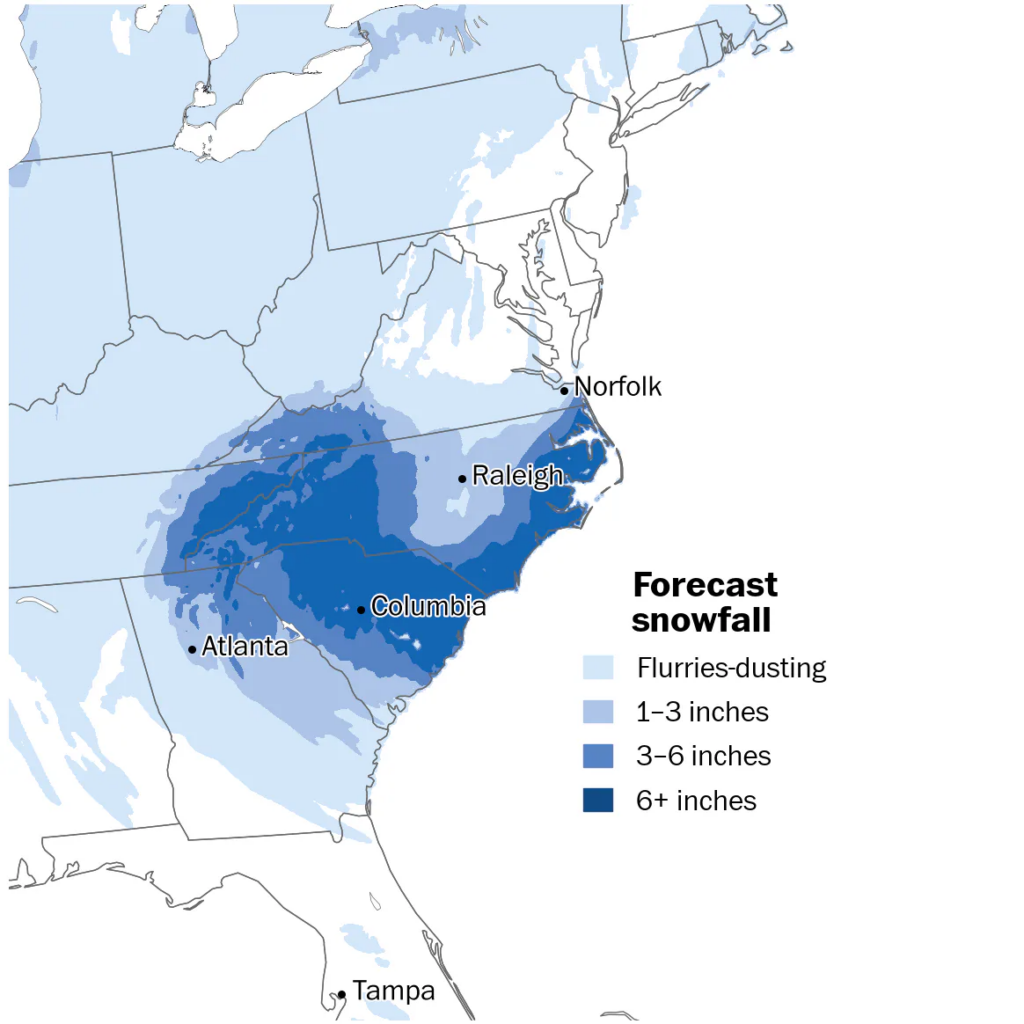
Heavy snow will fall across the southern Appalachians and Southeast from Saturday into Sunday, with whiteout and blizzard conditions in some areas. (Ben Noll/The Washington Post)
Along North Carolina’s Outer Banks, the National Park Service said in an email Friday that all visitor facilities along the Cape Hatteras National Seashore, as well as the Wright Brothers National Memorial, will be closed throughout the weekend and at least into Monday.
While significant snow events are rare along the Outer Banks, they aren’t unprecedented.
In an event dubbed the “Snowstorm of the Century,” Eastern North Carolina saw snowfall totals of 12 to 18 inches in March 1980, with localized amounts along the coast of two feet or more. That storm caused tens of millions of dollars in property damage and more than a dozen storm-related deaths in the state.
While the worst of the snow will spare Nashville, where more than 50,000 customers are without power, subzero wind chills are expected there this weekend. The city was hit hard both by last weekend’s storm and the ensuing outages that have left thousands still recovering.
It’s been almost a week since the ice storm tore through the region, but Toni Colgan can still hear the cracking of trees and branches buckling under the weight of ice every time she steps outside as the cold in Tennessee remains.
“It’s a whole new sound that I’ve never experienced,” said the operations lead for a corporate flower shop.
Now with a new storm poised to hit the region, residents are worried about the compounding risks.
“We’re ready for it to be over with,” Colgan said.
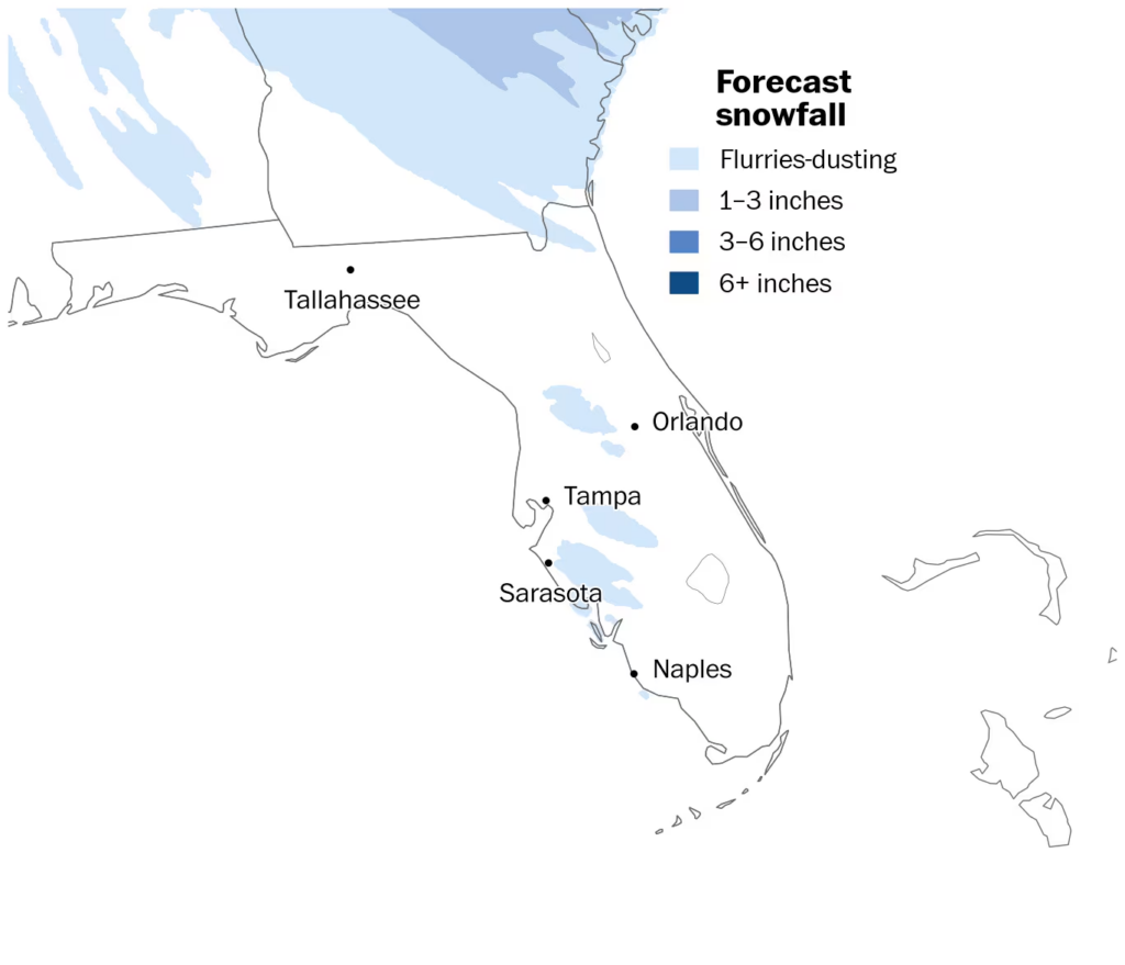
Florida is bracing for frigid temperatures and the potential for extremely rare snow late Saturday into Sunday. (Ben Noll/The Washington Pos)
Florida will also be on watch for extremely rare snow late Saturday into early Sunday. The sunshine state was already preparing early in the weekend as temperatures in some parts were forecast to dip below freezing into Saturday night.
Walt Disney World closed down its waterpark. The Central Florida Zoo wrote on social media they were offering visitor’s a discounted rate, “Because some of our animals may choose to stay inside this weekend.”
The weather could affect some of the state’s most iconic — or reviled — species.
“I think in Southern Florida, you’re going to see iguanas falling from the trees,” said Gov. Ron DeSantis in a Friday news conference. “I mean, a lot of them.” Iguanas become sluggish and “cold-stunned” when temperatures dip below 40 degrees. It could also kill off the Burmese Pythons, which are invasive to and have been wrecking havoc on the Everglades, the governor said.
On the backside of the potent storm, Arctic air will swirl across the Gulf of Mexico on Saturday night. Wind chills will drop into the 20s across South Florida and single digits in the Panhandle. It’s likely to be the coldest air mass since 2018.
Frigid air blowing over the warmer Gulf waters will lift moisture and generate ocean-effect snow showers, similar to what happens over the Great Lakes.
A few ocean-effect snow showers are likely near Pinellas, Manatee, Hillsborough, Polk, Sarasota, Pasco and/or Hernando Counties, and an isolated brief moderate squall can’t be ruled out. There’s even a potential for Tampa to see its first measurable snowfall since 1977.
If a few flakes fly across this zone, it would be rare but not unprecedented.
Excessive and long-lasting cold
The freeze will be deepening this weekend into early next week, when 18 states and D.C. may set daily low temperature records. Some of these records date back more than a century.
Here are a handful of the most remarkable predictions:
- Wilmington, North Carolina: low temperature of 13 degrees on Monday (current record: 17 degrees in 1980)
- Myrtle Beach, South Carolina: low temperature of 16 degrees on Monday (current record: 20 degrees in 1945)
- Savannah, Georgia: low temperature of 19 degrees on Sunday (current record: 23 degrees in 1977)
- Jacksonville, Florida: low temperature of 20 degrees on Sunday (current record: 24 degrees in 1977)
- Melbourne, Florida: low temperature of 24 degrees on Sunday (current record: 32 degrees in 1966)
- Orlando: low temperature of 25 degrees on Sunday (current record: 28 degrees in 1936)
- Miami: low temperature of 35 degrees on Sunday (current record: 36 degrees in 1909)
In D.C., temperatures have been below freezing since the evening of Jan. 23. After wind chills as low as minus-10 on Sunday morning, it may finally rise above freezing on Tuesday or Wednesday, concluding one of the city’s longest freezing streaks on record.
Matthew Cappucci contributed to this report.
Here are some “ETs” recorded from around the planet the last couple of days, their consequences, and some extreme temperature outlooks, as well as any extreme precipitation reports:
Here is More Climate News from Saturday:
(As usual, this will be a fluid post in which more information gets added during the day as it crosses my radar, crediting all who have put it on-line. Items will be archived on this site for posterity. In most instances click on the pictures of each tweet to see each article. The most noteworthy items will be listed first.)