The main purpose of this ongoing blog will be to track planetary extreme, or record temperatures related to climate change. Any reports I see of ETs will be listed below the main topic of the day. I’ll refer to extreme or record temperatures as ETs (not extraterrestrials).😉
Main Topic: Critical Hurricane Monitoring Data Is Going Offline
Dear Diary. Could you imagine what the political fallout would be if critical satellite information were put offline fir NORAD, or the North American Aerospace Defense Command? Howls would go up from just about every political corner because the eyes for keeping us safe from a nuclear attack would be blinded. Hurricanes aren’t nearly as destructive and don’t leave radiation in their wake, but they are the next worse destructive force that people along the Gulf and Atlantic coasts have to contend with. The Trump administration has effectively poked one of our eyes that lets us forecast hurricanes better.
The biggest responsibility of the president is to keep citizens safe, be it from foreign intervention, terrorism, or nature if possible. So why aren’t howls of protests going up for critical hurricane monitoring data going offline? If technology is available that does protect the public and is not astronomically expensive, it is the responsibility of the government to implement it. Trump and his cronies are failing to do this for hurricane warnings and preparedness.
Here are more details from the New York Times:
Critical Hurricane Monitoring Data Is Going Offline
The loss of access to the data could hamstring forecasters’ ability to track hurricanes and warn residents of their risk.
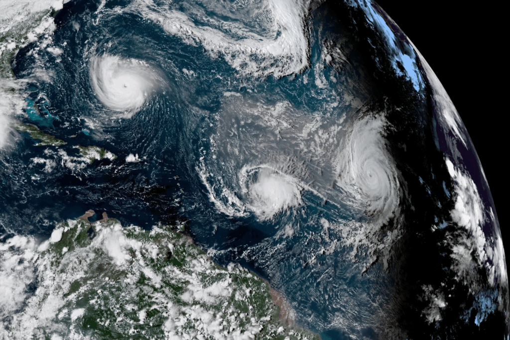
Satellite-based tools help forecasters monitor and model tropical cyclones and hurricanes.Credit…NOAA, via Associated Press

June 27, 2025
The National Atmospheric and Oceanic Administration has said that in the next few days it will stop providing data from satellites that have been helping hurricane forecasters do their jobs for decades, citing “recent service changes” as the cause.
The satellites are jointly operated by NOAA and the Department of Defense as part of the Defense Meteorological Satellite Program. They are old, dating to the early 2000s, but they have reliably helped improve hurricane forecasting for decades. The data will be halted by Monday, June 30, the agency said, without giving further explanation.
“This is an incredibly big hit for hurricane forecasts, and for the tens of millions of Americans who live in hurricane-prone areas,” said Michael Lowry, a hurricane specialist in South Florida who has worked at the National Hurricane Center and the Federal Emergency Management Agency.
The satellites orbit the poles and use microwave radiation to peer inside a hurricane to reveal changes in a storm’s structure. This information is critical for accurately predicting the path of storms and detecting hurricane intensification, particularly at night.
The satellites are not being decommissioned, but their data will no longer be received, processed or stored. Satellites can’t last forever and are eventually retired, but it is not clear that is the case here, said Andy Hazelton, a hurricane modeling expert at the University of Miami. “We don’t want to have less data for no reason,” he said.
Forecasters rely on various satellite-based tools to monitor tropical cyclones and hurricanes and predict their behavior. Observations of cloud tops and precipitation bands help forecasters see how a storm is moving and spreading. Come nightfall, microwave observation satellites work like forecasters’ night-vision goggles.
More on Hurricane Season
A Hurricane Season Like No Other
Google and U.S. Experts Join on A.I. Hurricane Forecasts
Nighttime observations of storm structure are particularly important because hurricanes tend to intensify, or see increases in wind speed and category, overnight as warm waters leach energy into the atmosphere.
“The nightmare scenario is going to bed with a tropical storm and waking up to a hurricane,” Mr. Lowry said. The canceled satellite data streams help avoid that unwelcome “sunrise surprise.”
Microwave observations also let forecasters pinpoint the center of a hurricane, which is essential for accurately predicting a storm’s direction. Being off even by a few miles can have “huge ramifications” for that, Mr. Lowry said.
A handful of other satellites with microwave observation capabilities will still have their data available to forecasters or researchers who have used that information. But the satellites provide only thin bands of coverage. There’s no guarantee the remaining ones will be able to provide data for a storm.
There’s not an obvious replacement for the data that will no longer be available although Kim Doster, NOAA communications director, in a statement pointed to a microwave instrument on another NOAA satellite that will still provide readings.
However, experts are still concerned about the data loss.
“We already don’t get as much microwave data as we’d like to see operationally,” Dr. Hazelton said.
“We’re going to lose about half the microwave images,” said James Franklin, a retired meteorologist who was the previous head of the hurricane team at the National Hurricane Center. With fewer satellite passes over a given part of the ocean, “forecasters will see hourslong delays in the National Hurricane Center recognizing that a storm has begun to strengthen abruptly.”
Editors’ Picks
How to Do a Perfect LungeThe Best Protein Bars Are the Ones You Make at HomeHappiness Doesn’t Have to Be a Heavy Lift
This is of particular concern because in the past two decades, hurricanes have been intensifying more rapidly and more frequently as a result of climate change. Microwave observations of storm structures are not “optional,” said Andra Garner, a climate scientist at Rowan University in New Jersey. “They’re critical.”
Identifying intensification as early is possible saves lives. Individuals need to prepare their homes, communities need to evacuate and emergency managers need to muster teams and resources.
The loss of data will affect hurricane research, too. Microwave observations of hurricanes, which have been collected by this family of satellites since 1987, built up a decades-long record of three-dimensional data on storm tracks, shapes and behaviors. “Our understanding of hurricanes is greatly improved because of that,” Mr. Lowry said. Without the data, “that eliminates the potential for research that could keep improving our forecasting.”
The data from the satellites was also used by international weather and maritime communities. Mexico and countries in the Caribbean use U.S. storm forecasts both for coastal and open-ocean areas. When hurricane and tropical storm forecasts are subpar, ships can be lost at sea, Dr. Franklin said.
The loss of the satellite data is the latest in a string of staffing, funding and data cuts since the Trump Administration took office in January. Hundreds of employees have left the National Weather Service since the beginning of the year, forcing some local offices to shutter their doors at night.
Judson Jones contributed reporting
More:
Here are more “ET’s” recorded from around the planet the last couple of days, their consequences, and some extreme temperature outlooks, as well as any extreme precipitation reports:
Here is More Climate News from Sunday:
(As usual, this will be a fluid post in which more information gets added during the day as it crosses my radar, crediting all who have put it on-line. Items will be archived on this site for posterity. In most instances click on the pictures of each tweet to see each article. The most noteworthy items will be listed first.)