The main purpose of this ongoing blog will be to track planetary extreme, or record temperatures related to climate change. Any reports I see of ETs will be listed below the main topic of the day. I’ll refer to record temperatures as ETs (not extraterrestrials).😜
Main Topic: Climate Changed Stuck Weather Pattern Will Lead to Wildfires in the West and Flooding Across the Deep South
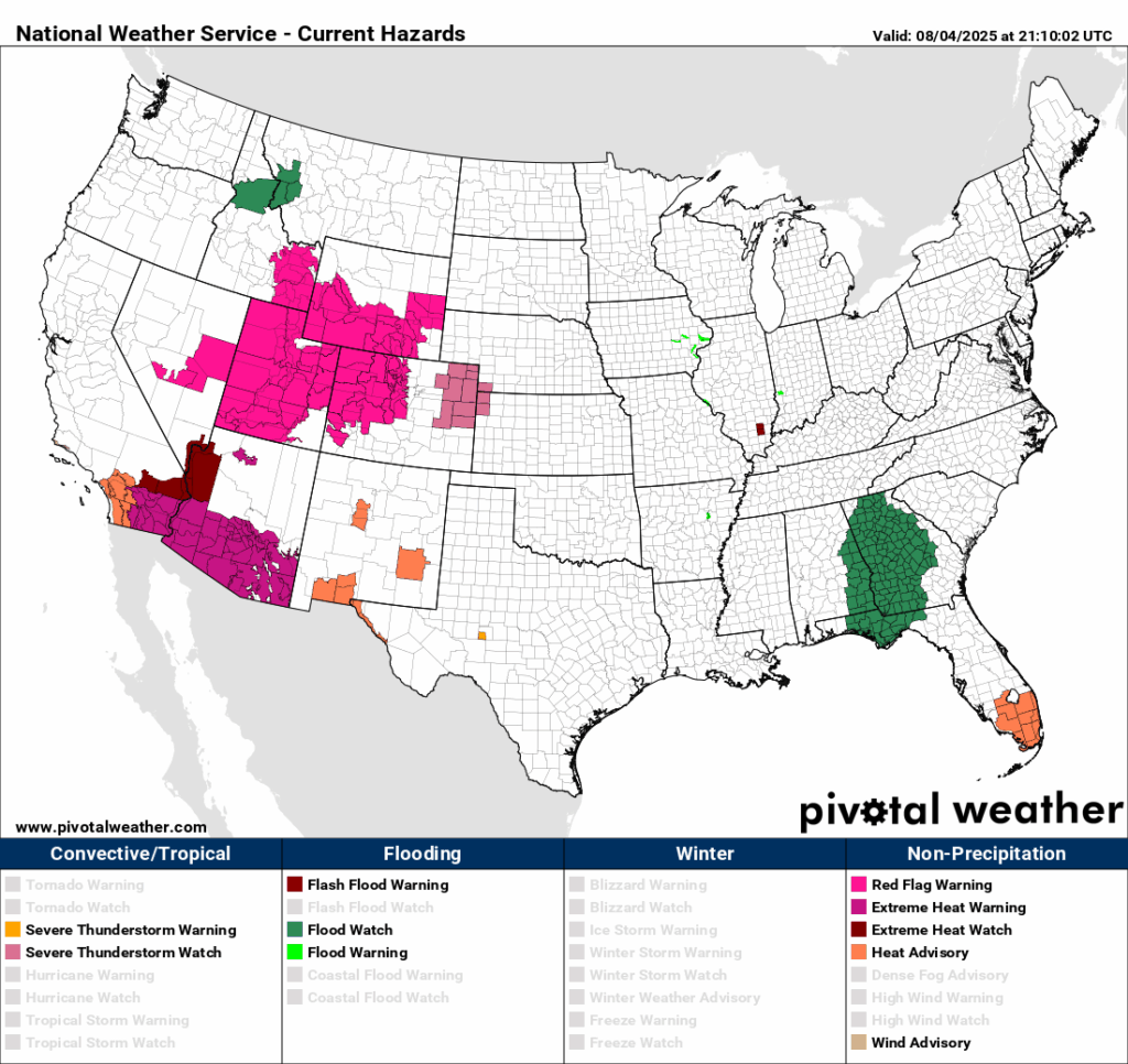
Dear Diary. This week we have another example of Dr. Michael Mann’s stuck summer jet stream pattern in which large heat domes are not moving. An area of weakness in between heat domes, or trough in between strong ridges, will likely produce some flooding where I live in Atlanta and other portions of the southeastern U.S.
Here is what we see from ensembles into Thursday of this week:

One can see the weakness, or dip in the jet, over the Southeast with a monster ridge parked over the Southwest and another east of the East Coast. This weather pattern squeezes Gulf moisture into the Southeast and can cause severe flooding. Don’t forget that due to climate change rainfall rates are increasing because warmer air holds more moisture.
The heat dome over the Southwest, in turn, is exacerbating drought and making fire conditions ripe for large configurations to explode:
Here are more details on flood potential from the Washington Post:
https://www.washingtonpost.com/weather/2025/08/04/flooding-threat-southeast-carolinas
Flooding rains threaten the South before risk moves toward Appalachia region midweek
Flood watches are in effect for the Florida panhandle, a big chunk of eastern Alabama and into much of Georgia on Monday and Tuesday. Additional watches will likely be issued for parts of the region in coming days.
August 4, 2025 at 4:10 p.m. EDT
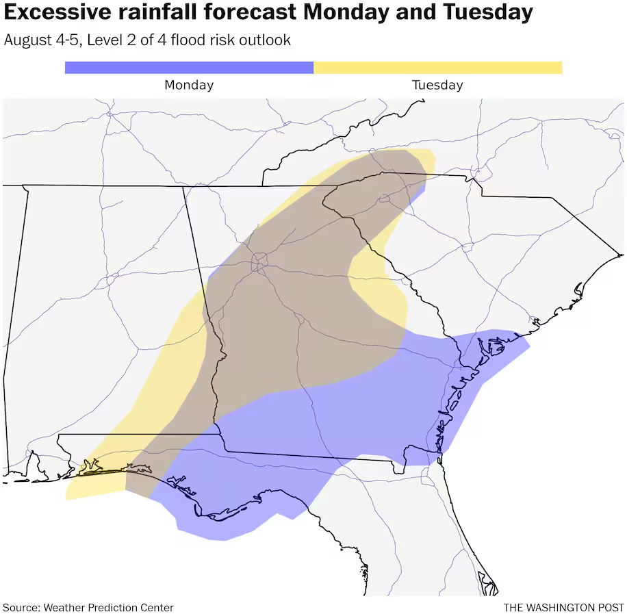

There’s a risk of flooding in parts of the Southeast and toward the Appalachians through at least middle of the week, fueled by a combination of a tropical disturbance near Florida and a dip in the jet stream over central United States.
Flood watches are in effect for the Florida Panhandle, a big chunk of eastern Alabama and into much of Georgia on Monday and Tuesday. Additional watches will probably be issued for parts of the region in coming days.
Areas near the Gulf Coast will be hardest hit in the short term, with multiple waves of showers and storms moving inland through over the next day.
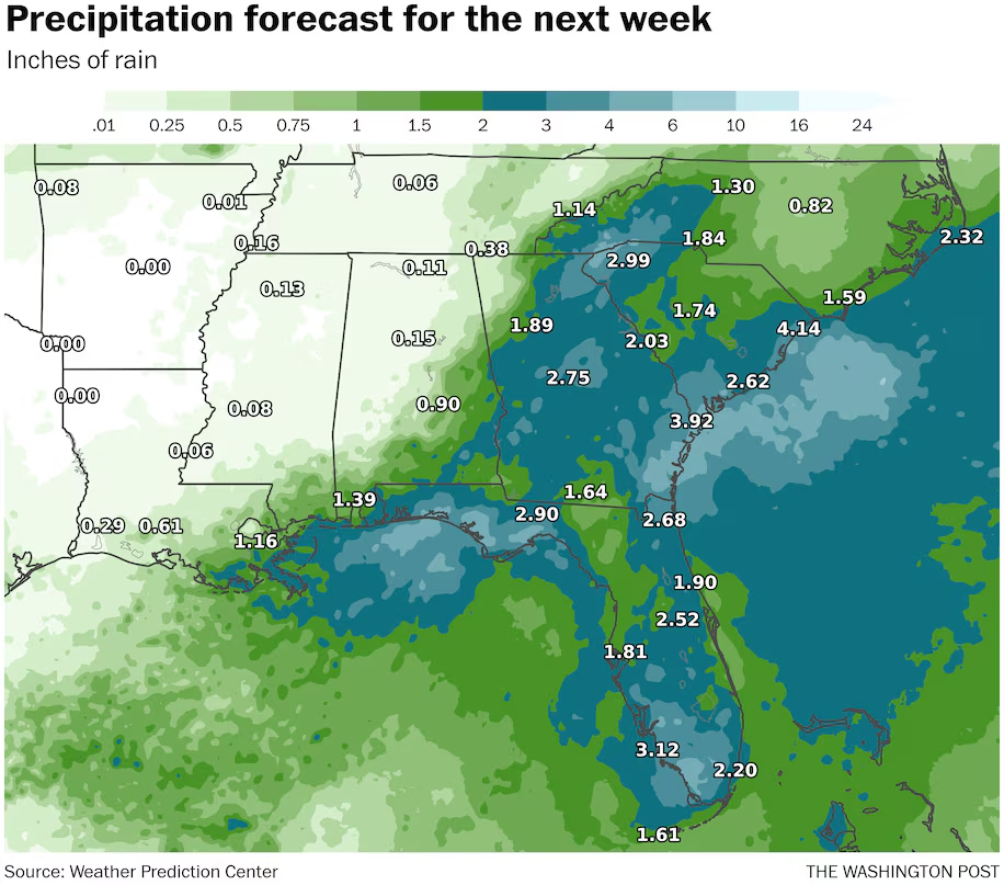
“Widespread rainfall amounts on the order of 1 to 3 inches are possible with isolated amounts up to 8 inches possible the next few days,” warned the Weather Service office in Tallahassee.
Dozens of flash flood advisories and warnings have been relayed by the National Weather Service already across the area. As much as 6 inches fell in southern Georgia, around Blakely, not far from the Florida and Alabama borders, where roads were over washed Sunday night into early Monday.
As the week progresses, the heavy rain threat shifts northward toward the southern Appalachians and the Carolinas.
Heavy rain hits the Gulf Coast region
A stationary front just inland from the Gulf Coast is acting as a conduit for heavy rain formation Monday, from Florida’s panhandle through parts of Alabama and Georgia.
The front is the same one that brought heat relief to much of the eastern U.S. over recent days after last week’s scorching conditions.
The amount of atmospheric moisture near the front is high, even for the middle of summer in a humid region. Precipitable water values — a measure of available moisture — are running about 150 percent normal. In such an environment, torrential rain is likely with any storms.
“Slow-moving thunderstorms will be capable of producing a ton of rain in a short amount of time,” the Weather Service in Tallahassee warned.
Multiple rounds of storms have already battered the shore Monday with squalls of heavy rain, gusty wind and waterspout risk. As those storms move inland, the heavy rain threat persists, especially where multiple storms cross the same path.
More storms blossoming offshore are also headed north.
Going into Tuesday, many of the same areas will be at risk for scattered flooding. It will also probably extend further northeast into portions of the western Carolinas.
Threat shifts northward through midweek
Heading into midweek, moisture is increasingly focused on the southern Appalachians and toward the Carolinas.
There’s more uncertainty in the forecast later in the week. But the potential for this bout of heavy, flooding rain could be long-lasting and could end up with persistent flow going into the mountains, which can squeeze out a good deal of rainfall.
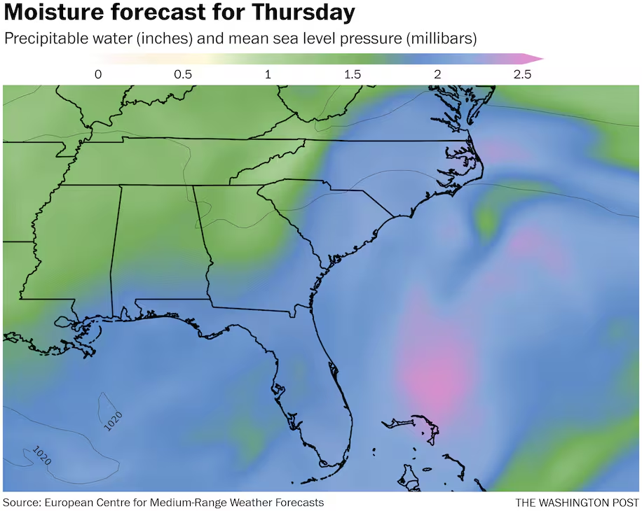
A particular wild card is how much additional moisture will accumulate, given the tropical disturbance off the coast.
The disturbance is not expected to strengthen much, but it will help pool moisture that can be pulled northward. With the peak of hurricane season now here, this disturbance along with Tropical Storm Dexter, which developed Sunday, and another system near Africa are pointing to increased activity ahead.
Dexter is not expected to affect any landmasses.
Totals could reach 10-plus inches in recently wet areas
Given the high moisture content and extended time with rainfall risk, totals in some portions of the Appalachians to the coastal Southeast could reach double digits.
The European weather model is suggesting this chance in west-central North Carolina and adjacent southern Virginia by the weekend. More could fall after. However, the American GFS keeps the heaviest rain near or just offshore, so there is a range of possibilities.
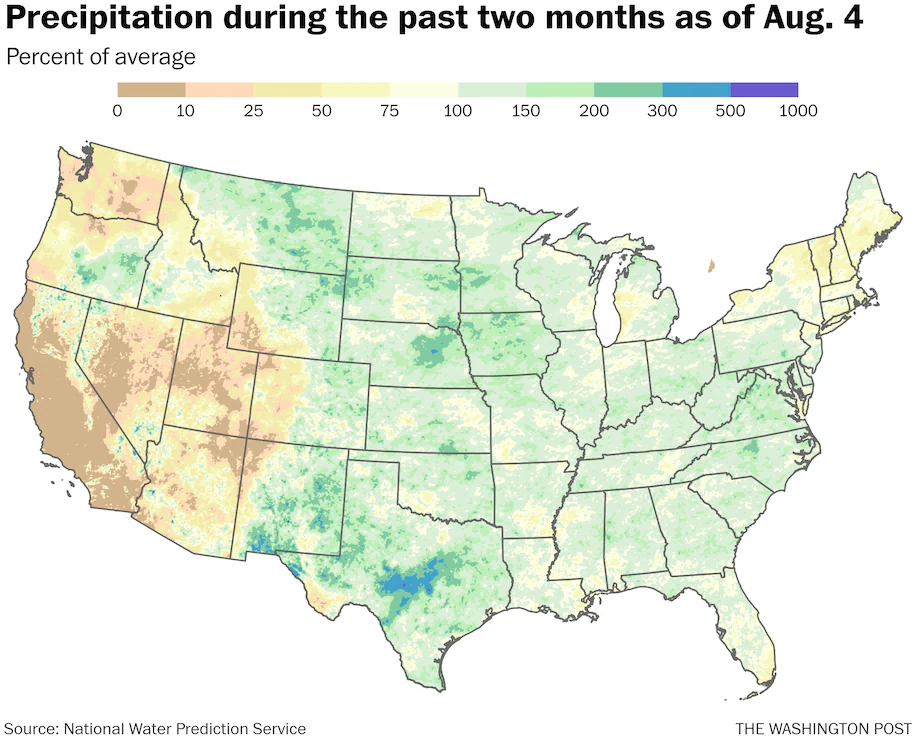
Portions of central South Carolina and the Piedmonts of North Carolina into Virginia are particularly waterlogged going in. The region has seen 15o to 200 percent normal rainfall over the past two months, which is a handful of inches above the norm.
Some of the same spots hit by Chantal flooding a month ago could eventually see heavy rainfall from this event.
In the Appalachians, Asheville, North Carolina, is about 5 inches above average for rainfall during the past two months.
The mountains are especially prone to piling up the precipitation and running into flood risk in scenarios where persistent winds from the southeast and east keep the rain coming for days. This potential will require monitoring.
By Ian Livingston Ian Livingston is a forecaster/photographer and information lead for the Capital Weather Gang. By day, Ian is a defense and national security researcher at a D.C. think tank.
Here are more “ET’s” recorded from around the planet the last couple of days, their consequences, and some extreme temperature outlooks, as well as any extreme precipitation reports:
Here is More Climate News from Monday:
(As usual, this will be a fluid post in which more information gets added during the day as it crosses my radar, crediting all who have put it on-line. Items will be archived on this site for posterity. In most instances click on the pictures of each tweet to see each article. The most noteworthy items will be listed first.)