The main purpose of this blog will be to track planetary extreme, or record temperatures related to climate change. Any reports I see of ETs will be listed below the main topic of the day. I’ll refer to extreme or record temperatures as ETs (not extraterrestrials).😜
Main Topic: Winter Solstice 2025 Arctic Sea Ice Update
Dear Diary. It’s high time for an Arctic sea ice report card. As many of you know, the areal extent of Arctic sea ice is a good yard stick to measure the health of our climate. If sea ice were to nearly disappear our climate would warm significantly because of lower albedo from darker open water.
This year’s report from Arctic sea ice researcher Rick Thoman is not good. Here are some nasty stats from his latest substack article:
Winter Solstice 2025 Arctic sea ice update
Winter Solstice 2025 Arctic sea ice update
Still at record low extent
Dec 22, 2025
Arctic sea ice extent as of December 21 was the lowest for the date in the satellite era (since fall 1978) in all the major analyses, i.e. National Snow and Ice Data Center (NSIDC), EUMETSAT OSI SAF, the Japanese Aerospace Exploration Agency (JAXA) and the U.S. National Ice Center/NSIDC Multisensor Analyzed Sea Ice Extent (MASIE). Total ice extent has been at or close to the lowest on record since early November (Fig. 1).
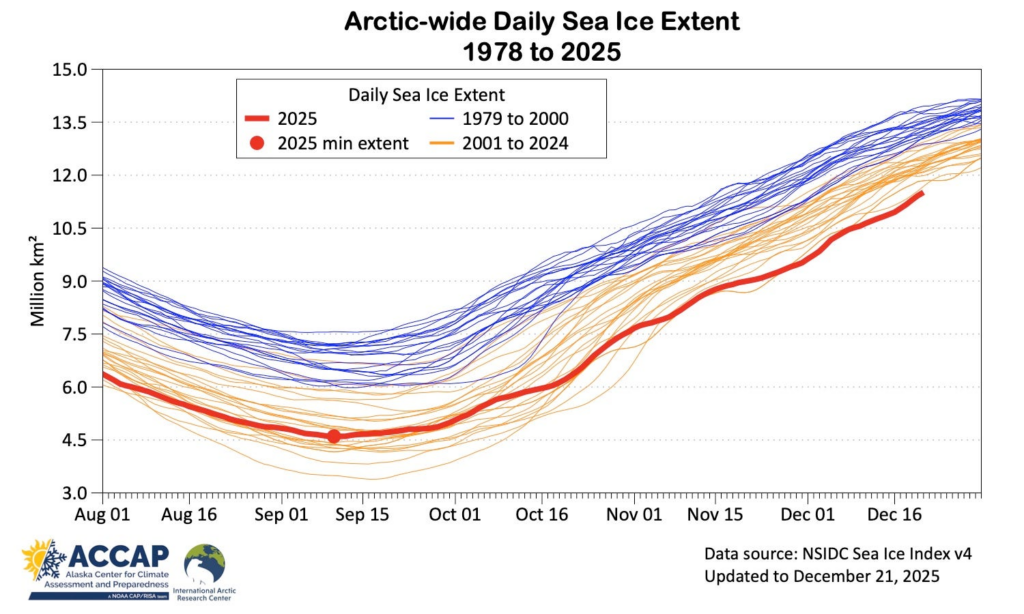
Fig. 1 Arctic-wide daily sea ice extent August through December. Data from the NSIDC Sea Ice Index version 4.
This record low extent is not a blip: Arctic-wide sea ice extent has been the lowest in the satellite era every day since late November (Fig. 2) in NSIDC data. So far in 2025, 106 days rank as the “lowest sea ice extent for the date”, including long stretches in late last winter and in early summer.
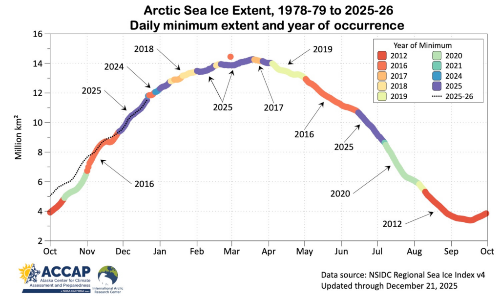
Fig. 2 The lowest daily sea ice extent each day of the year 1978-79 through 2025-26 with the year of occurrence color-coded. Data courtesy NSIDC.
Unsurprisingly, the sea ice edge is poleward of the long-term median in both Atlantic and Pacific sectors of the Arctic, but as has been in the case all year, most pronounced on the Atlantic side of the North Pole (Fig. 3 left). Analysis from Met Norway shows record low ice extent for winter solstice in the Svalbard sector, and in the central Arctic Basin northeast of Svalbard, there was open water to within 400 miles (650km) of the North Pole.
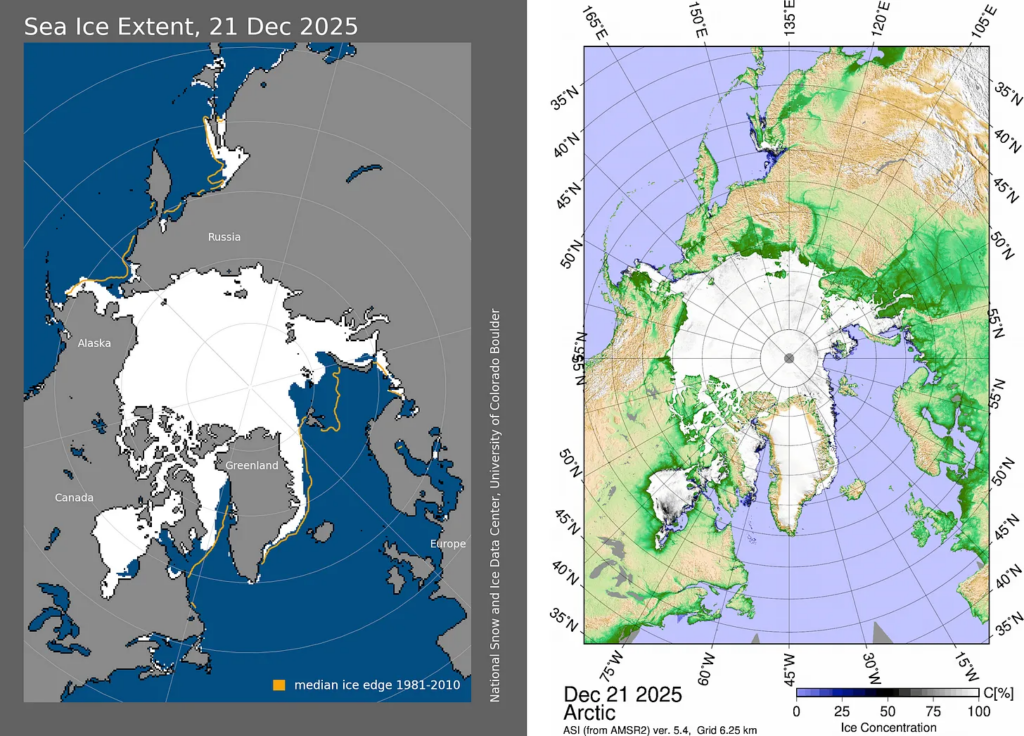
Fig. 3 Left: Sea ice extent and the 1981-2010 median as of December 21, 2025 from NSIDC analysis. Right: Sea ice concentration as of December 21, 2025 from AMSR2 courtesy U. Bremen.
Unlike summer and early autumn, except near the ice edge, ice concentrations during the winter are very high (Fig. 3 right). Large polynya (open water surrounded by sea ice) more commonly occur in the spring.
Regional sea ice extent
As is usually the case by winter solstice, some of the regional seas are completely ice covered. Where open water areas remain, ice extent on December 21 was the lowest of record in the Barents Sea, the Central Arctic basin, the Greenland Sea and Baffin Bay (Fig. 4). Hudson Bay is finally freezing over but some open water remains. While much of mainland Alaska has been significantly colder than normal this month, that cold weather has not extended as far west as the Bering Sea, where ice extent, which was above the normal for a while in early December, is now below the long term median.
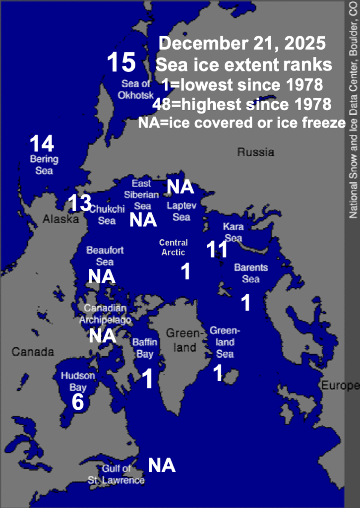
Fig. 4 Regional sea ice extent rankings for June 23, 2025, with 1 the lowest and 48the highest in the 1978-2024 period. Seas marked as “NA” are ice covered or seasonally ice-free. Data and base graphic courtesy NSIDC.
Sea ice thickness
Modeled sea ice thickness from the Danish Meteorological Institute shows ice more than two meters thick is confined to near the northern Canadian Arctic Archipelago coast, with smaller areas of thick ice in the eastern Beaufort Sea and off the northeast Greenland coast (Fig 5). It’s no surprise that the model ice thickness is quite low in the Kara Sea, but thin ice is also shown in the Laptev Sea, where there is very little ice more a meter thick.
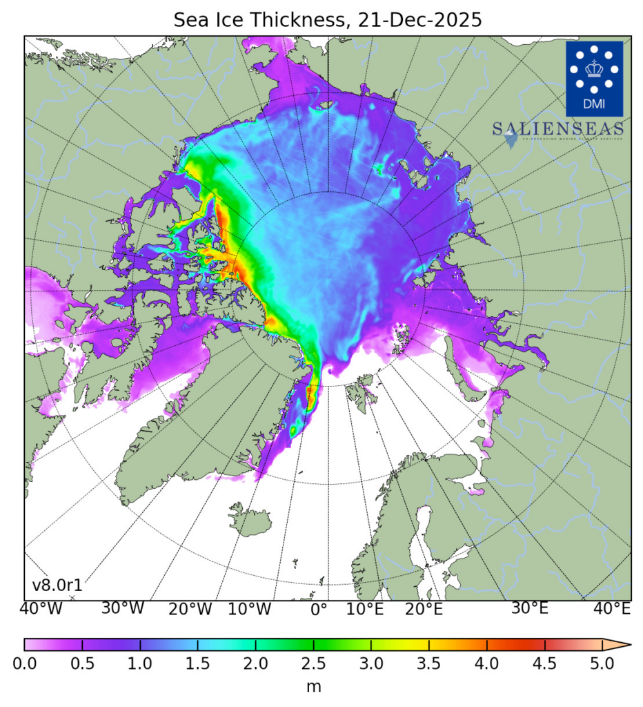
Fig. 5 Modeled sea ice thickness (meters) as of December 21, 2025. Image courtesy Danish Meteorological Institute.
Based on this model, total Arctic sea ice volume is even lower than last year at this point in the season, and so is the lowest on record for December 21.
Technical details and underlying data sources
As usual in this newsletter, Arctic means “poleward of 60°N” unless otherwise specified except for sea ice, where “Arctic” means all northern hemisphere sea ice.
NSIDC Arctic Sea Ice information, graphics and data available here.
Products from the OSI SAF High Latitude Processing Center (including but not limited to sea ice) are available here.
Arctic-wide sea ice extent data is available from JAXA here.
MASIE information and data available from NSIDC here.
AMSR2 data and graphics available from U. Bremen here.
Sea ice products from Met Norway are available here.
Modeled sea ice thickness and volume from the Danish Meteorological Institute is available here.
Here are some “ETs” recorded from around the planet the last couple of days, their consequences, and some extreme temperature outlooks, as well as any extreme precipitation reports:
Here is More Climate News from Friday:
(As usual, this will be a fluid post in which more information gets added during the day as it crosses my radar, crediting all who have put it on-line. Items will be archived on this site for posterity. In most instances click on the pictures of each tweet to see each article. The most noteworthy items will be listed first.)