The main purpose of this ongoing blog will be to track planetary extreme, or record temperatures related to climate change. Any reports I see of ETs will be listed below the main topic of the day. I’ll refer to extreme or record temperatures as ETs (not extraterrestrials).😉
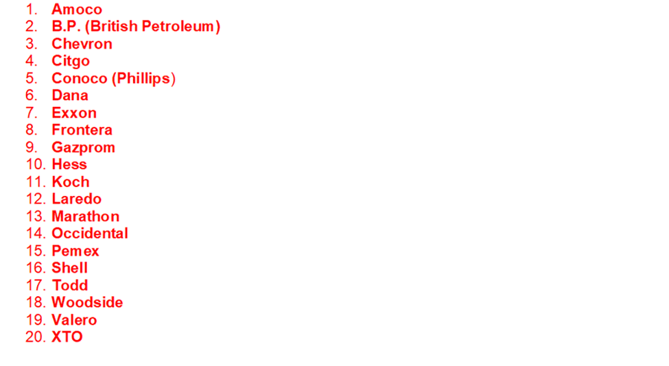
Main Topic: The Advent of Historic Heatwave Conoco (Phillips)
Dear Diary. Perhaps the worst heatwave of the U.S. summer has started today as what was left of Heatwave Chevron and Heatwave Citgo has quickly merged into one system…Heatwave Conoco (Phillips).
As a reminder, here is the list names that we are using to shame oil companies for making heatwaves worse:
So far, Heatwave Chevron was the worse U.S. heatwave mainly because it was so long lasting. RIP Heatwave Chevron 6/29/23 to 8/16/23.
Heatwave Chevron began in the Southwest. We can follow its heat dome center all the wave from 6/29 until it collapsed around 8/16:
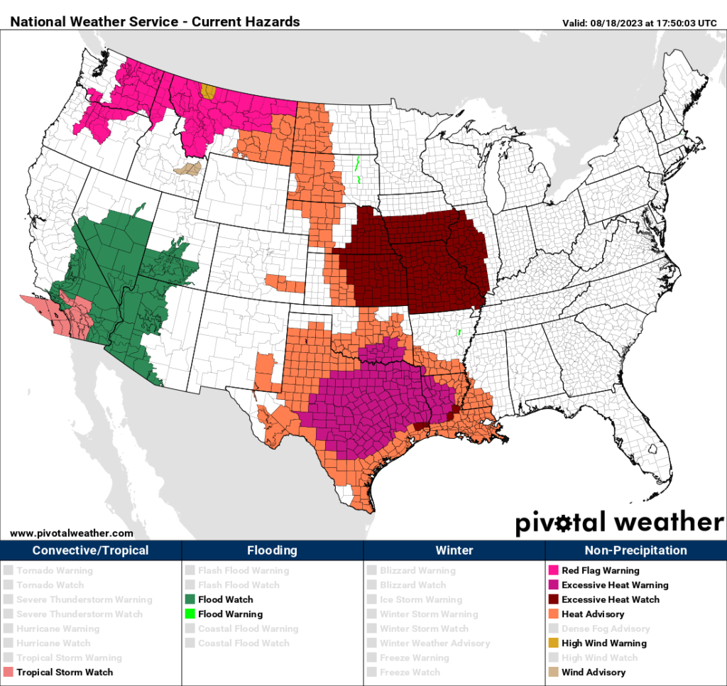
It could be argued that Heatwave Chevron never ended since heat advisories didn’t end across Texas from 8/16 through today:
Now extreme heat is rapidly expanding and spreading north through the Plains:
Technically, here is why I am declaring an end to Heatwave Chevron using my rules even though residents of Texas never got a break. On the 8/15 we can see a heat dome over Texas:

A cold core system had put an end to the heatwave across the rest of the Southeast. By the 16th the heat dome over the Texas had also dissipated, and the Pacific Northwest heat dome in association with Heatwave Citgo remained ongoing:

Yesterday the heat dome in association with Heatwave Citgo collapsed leaving a weak heat dome over the Rockies:

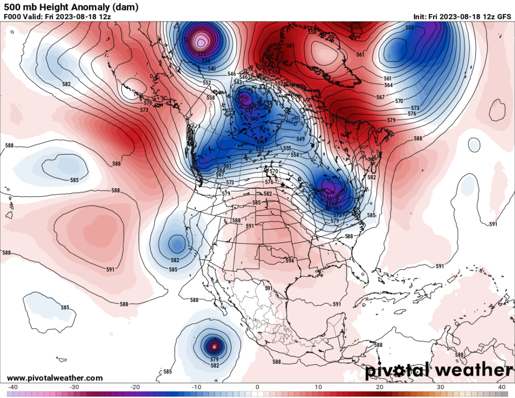
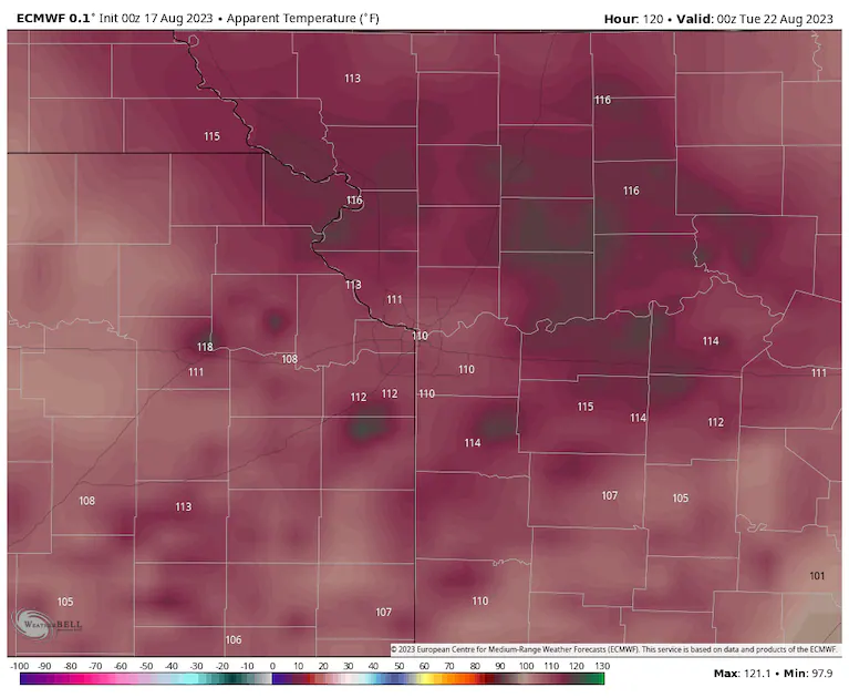
This “baby” from the prior two heat domes has quickly grown and moved eastward over the last 24 hours becoming a major CAT3 system looking at temperature and heat indices over Texas as of 8/18/23:
In just 72 hours Heatwave Conoco will grow into a 600+ decameter monster and get centered over Missouri and Kansas. Any heat dome getting above 600 decameters is quite rare. In my 40 years of being s meteorologist I have never seen one getting above 603 decameters:
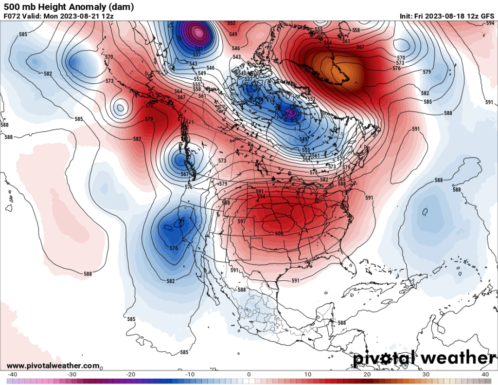
Of all the brutal heatwaves that have occurred across the U.S. so far this year, meteorologically, Heatwave Conoco will have the strongest heat dome. Every weather system, including Hurricane Hillary that will bring flooding into the Southwest, will revolve around this heat done the next several days. For a great video of a preview of the system see:
The Worst Heat Wave Of The Year Is Coming… – YouTube
Here is a Washington Post article describing what is ahead for Heatwave Conoco:
Heat wave coming to central U.S., with excessive heat warning in Texas – The Washington Post
Brutal heat wave coming to central U.S., with excessive heat warning in Texas

August 17, 2023 at 12:03 p.m. EDT
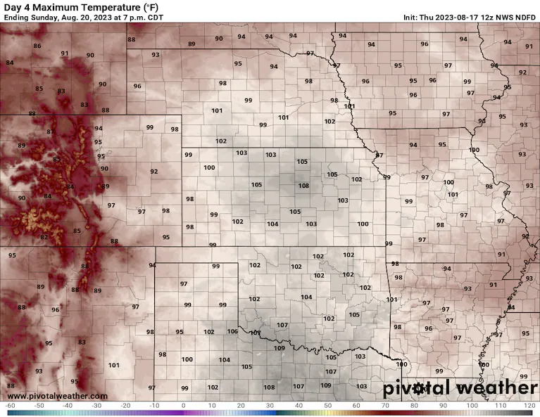
Temperature forecast for Sunday from the National Weather Service. (Pivotal Weather)
Dueling heat waves — across Texas and the South, and in the Pacific Northwest to northern Plains — are about to join forces to deliver the hottest stretch of weather this year to the central Plains and parts of the Midwest.
The focus of extreme heat remains on Texas, as well as portions of Washington state, Oregon, parts of California and the Desert Southwest, then into the northern Rockies. On Thursday, more than 60 million people were under heat alerts in those areas.
From Friday through the weekend, the expanding pulse of a high-pressure heat dome parked over the southern tier overtakes most of the central portion of the Lower 48 with record and near-record strength at its center. It might just be getting started.
“The ridge unfortunately looks to settle in and lead to a long-duration heatwave over the central U.S. into next week,” wrote the Weather Prediction Center in a Thursday discussion.
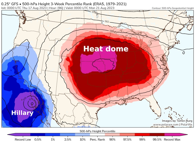
A huge heat dome is set to take over the Lower 48 this weekend. (PolarWx)
Underneath the heat dome, dozens of daily high marks are at risk, and some monthly or all-time readings may fall as well, including in places that have already piled up heat records this summer.
Extreme heat to overtake Central U.S.
Thursday is the final day of extreme heat in the Northwest before a cold front puts at least a temporary end to it. Record temperatures have been common since Sunday in the region, including a monthly record of 108 in Portland.

Record highs at risk in the coming days. (NWS)
Temperatures around 15 to 20 degrees above normal take over the northern and central high Plains on Friday. Parts of Montana, South Dakota and Wyoming may reach or surpass 100.
An advancing cold front means that the northern periphery of the hot weather — North Dakota, northern Minnesota, etc. — won’t see as extended a bout of heat.
Persistent anomalous heat is likely to anchor in the central Plains and Midwest, then into the South and Southeast. Widespread temperatures over 100 degrees are probable this weekend from Nebraska and Missouri southward to the Gulf Coast.
Once the record and near-record heat takes hold, it won’t loosen its grip much or at all through the week. Temperatures near and above 100 continue Monday to Friday for the same locations.
Incredibly, even on a week-long average, weather models are suggesting that temperatures could run 15 degrees or more above average — punishing, unflinching heat.
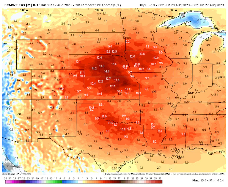
Temperatures are expected to be 15 degrees or more above average for a week-long period. (weatherbell.com)
Big heat, in widespread fashion
Dallas has seen a short break of temperatures below 100 degrees in recent days. It’s roaring back and won’t be departing anytime soon there.
An excessive heat warning Thursday and Friday could be extended given the forecast. The Weather Service is expecting highs to range from 105 to 108. Some good news for the region is that humidity might stay lower than it often is in midsummer. This means heat index values are close to the temperature or just above in most spots.
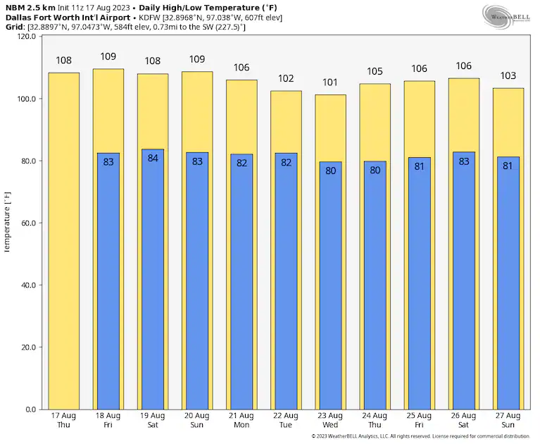
The National Blend of Models has 100s continuing in Dallas. (weatherbell.com)
Salina, in northeast Kansas, could see at least a week of highs at or above 100 per most weather modeling, starting Saturday and running through at least Friday. If that happens, it would be the longest streak since 2012 there. The Weather Service is forecasting 108 there both Saturday and Sunday.
“Models are outputting the warmest low-level temperatures in the 20-year model reanalysis for the weekend,” wrote the Weather Service in Omaha.
In the region near and north of northern Kansas into Nebraska, Iowa, and Missouri, humidity levels may spike as well. This can be attributed in part to vast croplands, largely corn, adding moisture to the air via “corn sweat.” A wobbling frontal zone north of there also aids in pooling moisture.
In those areas, heat indexes could rise to 115 or even as high as 120 under the right conditions, almost daily in some spots, this weekend into next week.
And after a short respite of intense heat in Louisiana — including New Orleans — and surrounding areas, temperatures tickling 100 are likely to return. As around Dallas, one slight bit of good news may be lower than typical humidity levels.
Heat index values of 110 to 120 are possible early next week around Kansas City. (weatherbell.com)
By mid-to-late next week, widespread temperatures around 100 or higher are possible, from the same regions that see it in coming days all the way to the East Coast.
Migrating heat domes
Summer 2023 has featured extreme heat bouncing from place to place, while focusing fury on spots like the Desert Southwest and Gulf Coast.
This expansion of the heat dome may be the most wide-reaching of the summer. By early in the coming workweek, most of the Lower 48 is forecast to see temperatures well above normal, with the West being the one exception.
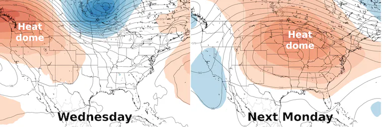
High pressure gathers strength and shifts east next week before being squashed south the week after. (Tropical Tidbits)
Above-normal temperatures look poised to persist through the rest of the month in most places.
In the longer range, about 10 to 14 days or so away, the heat dome may eventually be squashed back southward a bit. That might not mean much or any relief to the hardest hit by heat such as Texas.
Persistence of high temperatures is a hallmark of climate change. Often whipped up by slow or stalled weather patterns, the incidents of relentless heat have been numerous in recent years across the globe. A strengthening El Niño, characterized by warm water in the equatorial Pacific Ocean, is also adding fuel in 2023.
More on extreme heat
Our warming climate: July was Earth’s hottest month, and here’s where the worst, record-setting heat occurred. Phoenix set a national heat wave record for the hottest month ever in a U.S. city. Here’s why the sweltering heat wave isn’t moving anytime soon. Use our tracker to see your city’s extreme heat risk. Take a look at what extreme heat does to the human body.
How to stay safe: It’s better to prepare for extreme heat before you’re in it. Here’s our guide to bracing for a heat wave, tips for staying cool even if you don’t have air conditioning, and what to know about animal safety during extreme heat. Traveling during a heat wave isn’t ideal, but here’s what to do if you are.
Understanding the science: Sprawling zones of high pressure called heat domes fuel heat waves. Here’s how they work. You can also read more about the link between weather disasters and climate change, and how leaders in the U.S. and Europe are responding to heat.
By Ian Livingston Ian Livingston is a forecaster/photographer and information lead for the Capital Weather Gang. By day, Ian is a defense and national security researcher at a D.C. think tank. Twitter
Here are some other “ET’s” recorded from around the planet the last couple of days, their consequences, and some extreme temperature outlooks, as well as any extreme precipitation reports:
Here is some more July 2023 climatology:
Here is more climate and weather news from Friday:
(As usual, this will be a fluid post in which more information gets added during the day as it crosses my radar, crediting all who have put it on-line. Items will be archived on this site for posterity. In most instances click on the pictures of each tweet to see each article. The most noteworthy items will be listed first.)