The main purpose of this ongoing blog will be to track global extreme or record temperatures related to climate change. Any reports I see of ETs will be listed below the main topic of the day. I’ll refer to extreme or record temperatures as ETs (not extraterrestrials).😉
Main Topic: Correcting the News Media- No Evidence of Increased Cold Outbreaks Due to Recent Arctic Warming
Dear Diary. We have had some wickedly strong cold outbreaks, which have increased by my count across the U.S. and Canada since 2010 compared with those from the 2000s. The most recent brutal events were in February 2021, which produced a deadly historic Texas freeze, and the current one affecting most of the United States. I’ve noted that the recently increased number of Arctic outbreaks are mainly due to more negative phases of the North Atlantic Oscillation since 2010. Yet, the globe continues to warm. Yesterday’s diary post was titled It’s Bitterly Cold in the U.S. During the World’s Warmest January in History. So really, what’s up? Is the increased frequency of Arctic outbreaks just a statistical blip that will shortly end?
Dr. Jennifer Francis has theorized that the weakening of the polar vortex via climate change is causing amplification of the jet stream, leading to some outbreaks of cold air into mid-latitude areas. But are these more frequent and intense compared to decades past and as some media are now suggesting? Compared to the 1970s and 1980s, an era that I experienced as a young weather forecaster, in which I began to sharpen my skills by looking at many jet stream charts, I think not. In Atlanta we had some brutal years in the 1970s and 1980s in which the mercury got well below 0°F with many winter nights in the teens or colder. I’m confident that this season we will register just three or four nights below 20°F due to the cold outbreaks of this week. All models forecast a sharp warming trend going into late January, and I doubt that there will be more such major cold outbreaks during February.
While I think that Dr. Francis is correct concerning what Arctic outbreaks are left in our climate system moving forward in time, it is not correct to state that these are becoming “more frequent and more intense.” Let’s correct the record on this by presenting some recent science, which I applaud and have beseeched researchers to do for years:
More evidence that there is no detectable link between cold air outbreaks in the mid latitudes and recent Arctic warming.
— Dr. Jonathan Foley (@GlobalEcoGuy) January 17, 2024
Despite this, the media continues to push the opposite… https://t.co/Dy4yotxpRn
No detectable trend in mid-latitude cold extremes during the recent period of Arctic amplification
Communications Earth & Environment volume 4, Article number: 341 (September 28, 2023)
Abstract
It is widely accepted that Arctic amplification—accelerated Arctic warming—will increasingly moderate cold air outbreaks to the mid-latitudes. Yet, an increasing number of recent studies also argue that Arctic amplification can contribute to more severe winter weather. Here we show that the temperature of cold extremes across the United States east of the Rockies, Northeast Asia and Europe have remained nearly constant over recent decades, in clear contrast to a robust Arctic warming trend. Analysis of trends in the frequency and magnitude of cold extremes is mixed across the US and Asia but with a clearer decreasing trend in occurrence across Europe, especially Southern Europe. This divergence between robust Arctic warming and no detectable trends in mid-latitude cold extremes highlights the need for a better understanding of the physical links between Arctic amplification and mid-latitude cold extremes.
Spatial variations in the warming trend and the transition to more severe weather in midlatitudes
Article Open access 08 January 2021
Growing prevalence of heat over cold extremes with overall milder extremes and multiple successive events
Article Open access 01 April 2022
The increase in intensity and frequency of surface air temperature extremes throughout the western South Atlantic coast
Article Open access 25 April 2023
Introduction
The Arctic has experienced accelerated warming, observed to be between two to four times greater in the Arctic relative to the rest of the globe1, which is known as Arctic amplification (AA). Coincident with part or all of the period of AA, regions of the mid-latitude continents have experienced a cooling trend, with the most pronounced and consistent winter cooling trends in the interior of both Eurasia and North America2,3,4. The simultaneous occurrence of a relatively warm Arctic and cold continents is referred to as the warm Arctic/cold continents pattern5. Whether the juxtaposition of the two opposite anomalies, a north-south dipole, are coincidental and physically unrelated or whether the two are dynamically linked whereby the rapidly warming Arctic is contributing, at least in part, to more severe winter weather in parts of Eurasia and/or North America, has been debated for at least a decade and remains unresolved3. However, in recent years, targeted community-wide efforts have been developed to work toward a consensus view6.
Despite the accelerated Arctic warming, there have been a surprising number of historic cold air outbreaks in the United States (US) and Asia in recent years, which may even be increasing4, 7,8,9,10 in frequency. In both 2021 and 2022, two of the deadliest and costliest US natural disasters have been related to extreme cold and/or heavy snowfall11. These societally impactful extreme weather events have garnered much media attention12,13,14,15.
Overall, however, global warming is clearly reducing the number of cold extremes16. A common argument applied to mid-latitude cold events is that, given that the Arctic is the source region for cold extremes across the mid-latitudes, as the Arctic warms more rapidly than other regions of the globe, cold extremes will moderate or warm and occur less often17,18,19. A recent report from the National Academies of Science when assessing the change in frequency of all weather extremes, was most confident in the decrease of cold extremes20.
The recent events in the US and Asia suggest that there may be exceptions to the overall decreasing trend in cold extremes, and that the link between AA and cold extremes may not be straightforward and linear but rather more complex. In particular, the potential for AA to contribute to a dynamical cooling across the mid-latitudes that at least partially offsets radiational and thermodynamic warming of the Arctic needs to be considered. It has been shown that a local anomalous meridional circulation, especially blocking, plays an important role in bridging AA and mid-latitude extreme cold events21. It has been a recent topic of interest if AA can increase or amplify meridional circulations, especially blocking events.
There are two generalized theories as to how AA can contribute to an increased meridional circulation that delivers severe winter weather across the mid-latitudes. The first theory is that a weakening of the equator-to-North Pole temperature gradient results in a slackening of the westerly jet stream, which then favors more amplified and more slowly eastward propagating large scale- or Rossby-waves across the mid-latitudes. The more amplified and persistent flow contributes to more extreme weather in general, including more severe winter weather22. The second theory is that heterogenous heating across the Arctic forced by uneven melting sea ice and/or greater snowfall across the continental regions of the Arctic acts to amplify or persist high latitude blocking that forces a weaker stratospheric polar vortex23,24. In apparent support of this theory, the frequency of severe winter weather across the mid-latitudes increases following a relative weak and distorted stratospheric polar vortex2,4.
In an effort to better contextualize the relationship between AA and mid-latitude cold extremes, we conduct a comprehensive trend analysis starting before and during the period of AA. For our analysis we have computed trends spanning the winter season of both Arctic temperatures and extreme cold in the major population centers of the Northern Hemisphere mid-latitudes: the Eastern US, Northeast Asia, Northern Europe, and Southern Europe.
Results
To test whether observational analysis shows that AA is contributing to a moderation or warming of cold extremes in the mid-latitudes, we computed temperature trends in both the daily cold extremes for the midlatitude regions and for the Arctic just prior to observed mid-latitude cold extremes. For each region, trends in both the number of events and the temperature of events are compared to the corresponding Arctic values for the period extending through the present and starting from three different starting points: 1960, 1990, and 2000. This allows a comparison of trend behavior over the longer period with the more recent period of AA. Since there is some disagreement about the start date of AA, with some studies arguing an earlier start date circa 19902,25 and some a later start date circa 200026,27, we computed trends for both AA periods. Assuming that it takes a few days for the cold air to travel from the Arctic to the mid-latitudes and following the results of Li et al.28 who found that that the strongest high latitude circulation anomalies and associated cold air advection are observed three days prior to the greatest Eurasian cooling related to Arctic warming, we used a three-day lead time to compute Arctic temperatures; however, our results are not sensitive to choice of lead time. All cold extreme events are plotted as a series in sequential order. We then compute the winter trends starting in 1960 (decades earlier than the observed start of AA), and then we recompute the trends limited to the more recent period of AA, for both the longer and shorter definitions.
We define a cold extreme when the December, January and February (DJF) daily average temperature falls below the 5th percentile of the daily average temperature distribution for DJF (see Methods). As for many extreme weather events there is no single standard definition of cold extremes. Thompson and Wallace29 and Tang et al.30 define cold extremes as when the daily minimum temperature drops below the threshold of 1.5 standard deviations of the seasonal mean. Johnson et al.31 define a cold extreme when the maximum temperature anomaly based on the seasonal mean for a given day falls below the 10th percentile of the maximum temperature anomaly distribution of 5-day rolling means. van Oldenborgh32 defined a cold extreme as the lowest minimum temperature at any given location. At the end of our study, we repeated the analysis with other previously used definitions of cold extremes and did not find that our conclusions are sensitive to a specific definition.
For this analysis, we define four mid-latitude regions and an Arctic region. The Arctic region is defined as the area poleward of 70°N, to closely match the region of accelerated warming in Fig. 1 of the analysis of Rantanen et al.1. We also analyze four mid-latitude regions to compute regional average temperatures and cold extremes, with the regions chosen based on societally impactful cold events and their relationship to high-latitude variability. The regions are the Central-Eastern US region (labeled CEUS), the Northeast Asia region (labeled SSNC for Southern Siberia/Northern China), Northern Europe (NEUR) and Southern Europe (SEUR), outlined with boxes in Fig. 1. The teleconnection index that is most closely related with extreme winter weather in the mid-latitudes is the Arctic Oscillation (AO)29 where the negative polarity is associated with an increase in severe winter weather including below- to well below-normal temperatures widespread across the mid-latitudes. This index is also the teleconnection pattern most closely associated with stratospheric polar vortex variability33, where a weak stratospheric polar vortex favors the negative polarity of the AO and widespread below-normal temperatures across the mid-latitudes34. In Fig. 1 we show the regression of the negative polarity of the North Atlantic Oscillation (NAO), which we treat as equivalent to the AO, and Northern Hemisphere surface temperatures. The three mid-latitude regions where cold air outbreaks are most strongly related to a negative NAO or AO are the US east of the Rockies, East Asia and Northern Europe (CEUS, SSNC, and NEUR, respectively). Siberian surface temperature is also highly sensitive to NAO or AO variability but is of less interest because of its northern latitude and sparse population.
Fig. 1: Eastern US, Northern Europe, and East Asia all share cold temperatures during the negative polarity of the NAO.
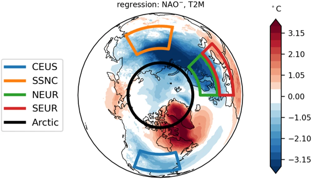
Northern Hemisphere December–February (DJF) surface temperatures are regressed onto the NAO index shown for the negative polarity. Also shown are the five regions of analysis: the Arctic and four mid-latitude regions, Central and Eastern US (CEUS), Southern Siberia and Northern China (SSNC), Northern Europe (NEUR), and Southern Europe (SEUR).
We also analyze a fourth region where cold air outbreaks are less common, Southern Europe (SEUR), for comparison. This is one region in the mid-latitudes where below-normal temperatures are not associated with a negative AO or NAO and a weak stratospheric polar vortex. Additionally, as will be shown, it is in clear contrast from the other three analyzed regions in that it has a consistent trend for all three periods analyzed in this study and in previous studies when mid-latitude cooling trends were more widespread and of greater magnitude (see Fig. 2 of Cohen et al.2).
Fig. 2: Arctic and mid-latitude temperature trends have been consistent since 1960 but in parts, diverge during AA.
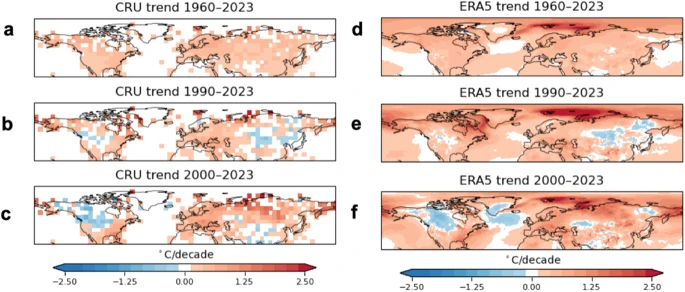
Northern Hemisphere DJF temperature anomaly trends since a 1960, b 1990 and c 2000 using CRU data. d–f same as (a-c) but using ERA5.
To provide seasonal context, the DJF seasonal mean surface temperature trends and the time series of winter surface temperature trends for each of the five regions analyzed in this study (CEUS, SSNC, NEUR, SEUR and Arctic) are shown in Fig. 2. All trends are shown for all three periods: since 1960, 1990 and 2000. For the DJF seasonal mean, all four mid-latitude regions are warming but the Arctic is warming at least twice as fast as the mid-latitude regions since 1960 and 1990 consistent with the results of Cohen et al.2. However, since 2000, the warming trend in the Arctic has slowed while the warming in the mid-latitudes has accelerated and consequently, Arctic warming is comparable to the warming trend in the mid-latitudes since the beginning of the twenty-first century.
We then establish consistency with previous work by repeating the analysis of Cohen et al.2 that showed since 1960 the entire Arctic and Northern Hemisphere (NH) extratropical land regions were warming using the Climate Research Unit (CRU) land station temperature version five (CRUTEM5) dataset derived from station data only to exclude any bias introduced by reanalysis. Here too, all land regions of the Northern Hemisphere are warming since 1960 (shown in Fig. 3). The NH trend analysis is consistent with the idea that global warming contributes universally to warming winter surface temperatures. Next, we repeat the trend analysis for both periods of AA since 1990 and 2000. Similar to the analysis in Cohen et al.2, over the period of AA cooling trends appear in the continental region of the mid-latitudes but are of smaller extent and magnitude than shown in Cohen et al.2. Interestingly, the cooling trend in North America has strengthened in the most recent period while it has weakened in Eurasia. It could be argued that the North American cooling since 2000 is more impressive than previous similar winter trend analysis during AA shown in Fig. 1 of Cohen et al.35 and Fig. 2 of Cohen et al.2. In contrast, Eurasian cooling is weaker and contracted compared to earlier winter trend analysis.
Fig. 3: Mid-latitude winter temperatures have been warming since 1960 but are mixed since 1990.
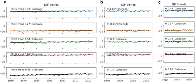
a DJF temperature trend 1960–2023 from ERA-5 for the CEUS, SSNC, NEUR, SEUR, and Arctic regions, b same as (a) but for 1990–2023 and c same as (a) but for 2000–2023.
For the remainder of the trend analysis, we use the fifth-generation ECMWF atmospheric (ERA5) reanalysis. The advantage of ERA5 is that coverage of the Arctic Ocean is complete in contrast to CRUTEM5 which is limited to land points only and the main focus of our analysis is to relate AA to mid-latitude cold extremes. For the period since 1960, ERA5 also exhibits universal warming across the Northern Hemisphere (Fig. 3). For the two AA periods, a general pattern of amplified Arctic warming with some cooling in the mid-latitudes is evident but the cooling is less in ERA5 when compared to CRU. It is beyond the scope of this study, but it is possible that ERA5 introduces a warm bias in the latter years of the record in the mid-latitudes that weakens the observed cooling trends.
Next, in Figs. 4–7, we present the trends in cold extreme events for each of the midlatitude regions analyzed in comparison to the Arctic, in terms of both event number and temperature, for all three periods. In Fig. 4, we plot the annual frequency and area average surface temperature for the US east of the Rockies (CEUS; Fig. 1 blue box) for the 5% coldest DJF days of the entire period (color-coded by decade) and the Arctic (Fig. 1 bold black circle) surface temperature from three days earlier than the date of the observed cold extreme. Consistent with the universal warming of the NH there is a statistically significant decreasing number of extreme cold days in the US since 1960. Though there is a warming trend in the coldest days of the year, the trend is not statistically significant in contrast to the warming trend in Arctic temperatures, which is statistically significant. We then repeat the analysis limited to the two AA periods. The Arctic is warming for both AA periods but is only statistically significant for the longer period. In contrast, the trend in CEUS cold extremes frequency is decreasing for the longer period but increasing for the shorter period, although neither trend is statistically significant. Similarly, the temperature trend of CEUS cold extremes is mixed for both AA periods. The only statistically significant trend in cold extremes for CEUS, is a statistically significant cooling trend for the shortest period since 2000. There is a clear divergence in the trends of Arctic temperatures, which are robustly warming, and cold extremes in the US, which exhibit no statistically significant trends during the period of AA and even for the longer period since 1960.
Fig. 4: A robust warming trend is observed in the Arctic but no consistent trend is found for Eastern US cold extremes.
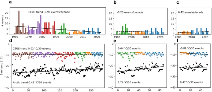
Frequency of Central-Eastern US (CEUS; shown in Fig. 1) DJF 5% coldest events for (a) 1960–2023, (b) 1990–2023, and (c) 2000–2023, demarked with colored bars to represent each decade, and showing the linear trend line. The slope of the trend line is indicated in each panel (events/decade). The temperature for each cold CEUS event (colored dots) is shown in (d, e, and f) for the same time periods as in (a, b, and c). Corresponding Arctic temperatures are shown with black dots. The trend lines indicate tendency in temperature over the ordered events, and the slope of the trend is indicated in each panel (°C per 30 events). Trend lines are shown solid if trend is significant at the 0.05 level, dashed otherwise.
Fig. 5: A robust warming trend is observed in the Arctic but no consistent trend for Northeast Asia cold extremes.
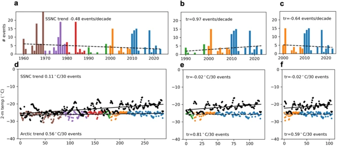
Frequency of Northeast Asia (SSNC; see Fig. 1) DJF 5% coldest events for (a) 1960–2023, b 1990–2023, and c 2000–2023, demarked with colored bars to represent each decade, and showing the linear trend line. The slope of the trend line is indicated in each panel (events/decade). The temperature for each cold SSNC event (colored dots) is shown in (d, e and f) for the same time periods as in (a, b and c). Corresponding Arctic temperatures are shown with black dots. The trend lines indicate tendency in temperature over the ordered events, and the slope of the trend is indicated in each panel (°C per 30 events). Trend lines are shown solid if trend is significant at the 0.05 level, dashed otherwise.
Fig. 6: A robust warming trend is observed in the Arctic but no consistent trend is found in the magnitude of Northern Europe cold extremes.
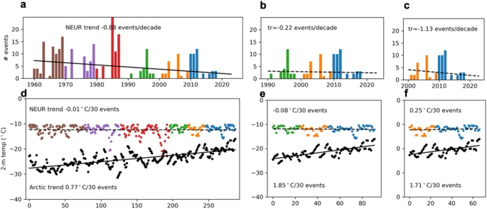
Frequency of Northern Europe (NEUR; see Fig. 1) DJF 5% coldest events for (a) 1960–2023, (b) 1990–2023, and (c) 2000–2023, demarked with colored bars to represent each decade, and showing the linear trend line. The slope of the trend line is indicated in each panel (events/decade). The temperature for each cold NEUR event (colored dots) is shown in (d, e, and f) for the same time periods as in (a, b, and c). Corresponding Arctic temperatures are shown with black dots. The trend lines indicate tendency in temperature over the ordered events, and the slope of the trend is indicated in each panel (°C per 30 events). Trend lines are shown solid if the trend is significant at the 0.05 level, dashed otherwise.
Fig. 7: Southern Europe is experiencing a notable decrease in the frequency of cold extremes.
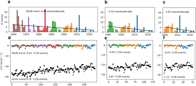
Frequency of Southern Europe (NEUR; see Fig. 1) DJF 5% coldest events for (a) 1960–2023, (b) 1990–2023, and (c) 2000–2023, demarked with colored bars to represent each decade, and showing the linear trend line. The slope of the trend line is indicated in each panel (events/decade). The temperature for each cold SEUR event (colored dots) is shown in (d, e, and f) for the same time periods as in (a, b, and c). Corresponding Arctic temperatures are shown with black dots. The trend lines indicate tendency in temperature over the ordered events, and the slope of the trend is indicated in each panel (°C per 30 events). Trend lines are shown solid if trend is significant at the 0.05 level, dashed otherwise.
In Fig. 5, we repeat the analysis of Fig. 4 but for Northeast Asia (SSNC; Fig. 1 orange box) and the Arctic. Though there has been a decreasing number of extreme cold days in the SSNC region since 1960, it is not statistically significant. Over the period of AA, the frequency of extreme cold days is mixed for Northeastern Asia with the frequency of extreme cold days increasing for the longer period of AA but decreasing for the shorter AA period, reversed of what is found the Eastern US. However, similar to the CEUS, the trend is not statistically significant. For both AA periods, there is a very slight negative trend in the temperature of coldest days of the year but again neither trend is statistically significant. Consistent with what was shown for North America, there is a clear divergence between the trends in Arctic temperatures, which are robustly warming, and cold extremes in Northeast Asia, which exhibit no statistically significant trends over the period of AA.
To complete the analysis of those regions that experience frequent cold air outbreaks across the Northern Hemisphere during the negative polarity of the NAO or AO and/or a weak stratospheric polar vortex, we show the same analysis for Northern Europe (NEUR; Fig. 1 green box) in Fig. 6, despite that previous cooling trends in Europe (e.g., Cohen et al.2) have all but disappeared with the inclusion of the most recent winters, in contrast to North America and Asia, as shown in Fig. 3. Cold extremes in Europe also lack a warming trend not only during both AA periods, but even starting in 1960, though the frequency is decreasing at a rate similar to the US. Also like the US for the two periods of AA, the temperature trend of cold extremes is mixed between the two AA periods. However, in contrast to the US and Asia, the frequency of cold extremes is decreasing for all periods, especially since 2000, though it is only statistically significant for the longer period since 1960.
For comparison to the three mid-latitude regions where cold air outbreaks are more common, we analyze the temperature trends of cold extremes in Southern Europe (SEUR) in Fig. 7. In contrast to the other three regions analyzed, SEUR region experiences less frequent Arctic outbreaks and does not exhibit a strong relationship between cold extremes and either a weak stratospheric polar vortex or a negative AO or NAO. Unlike the US, Asia and even Northern Europe, Southern Europe is the only region experiencing a statistically significant decrease in the frequency of cold extremes during the two AA periods, which based on our analysis, is accelerating. Interestingly, though, it is also experiencing a negative trend in cold extremes for all three periods. This negative trend in cold extremes is largely due to the recent winters of 2012 and 2018. The severity of the cold in the 2000s was last matched in the 1960s for Southern Europe.
All trends shown in Figs. 4–7 are summarized in Table 1 for ease of comparison. In Supplementary Table 1 we compute an alternate temperature trend of extreme cold per decade, showing that our analysis is not sensitive to whether we compute the trend by event or over time. What is immediately apparent from Table 1 (and Supplementary Table 1) is that the robust Arctic warming trend stands in contrast to all four mid-latitude regions where trends are mixed no detectable warming trends are found with the exception of Northeast Asia for the longest period since 1960.
Much More:
Related Articles:
US in deep freeze while much of the world is extra toasty? Yet again, it's climate change. I explain how the polar vortex is more frequently escaping a warming Arctic. World is still near record hot, but US is left out in the cold. https://t.co/XWgPHeyTVn
— @borenbears (@borenbears) January 16, 2024
Our (@xueke_li, @MichaelFWehner, Stefan @rahmstorf
— Prof Michael E. Mann (@MichaelEMann) January 17, 2024
Stefan Petri, @sh_christiansen, @juditcarrillo & yours truly) new article in @PNASNews showing the precursor role that atmospheric resonance played in the unprecedented 2021 Pacific Northwest "Heat Dome" event https://t.co/RLbC70i32A pic.twitter.com/R1koZYbGjU
Here are more “ET’s” recorded from around the planet the last couple of days, their consequences, and some extreme temperature outlooks, as well as any extreme precipitation reports:
Incredible cold last night over the snow cover with widespread negative teens in Tennessee Valley. (1/2)
— Jesse Ferrell (AccuWeather) (@WeatherMatrix) January 17, 2024
Monticello, KY: -22 F*
Liberty, TN: -14
Lamar, MS: -13
Dunmore, WV: -12
Tuscumbia, AL: -10
Mount Washington, NH: -10 pic.twitter.com/I3sqIbK7fC
Harsh heat wave In South America with hot days and nights and high humidity
— Extreme Temperatures Around The World (@extremetemps) January 17, 2024
In BRAZIL🇧🇷 historic record of highest minimum in history at Curitiba with 23.4C and for January at Sao Paulo with 25.1C
In BOLIVI🇧🇴 record heat also at high elevations with 37.4C at Tarija at 1850m asl pic.twitter.com/qvlz3vKjwn
UNBELIEVABLE
— Extreme Temperatures Around The World (@extremetemps) January 17, 2024
What it's happening these hours is completely rewriting European climatic history.
Summer temperatures tonight up to Balearic Islands,
Pollenca reached 22.8C at 03:20am lt,a temperature typical of July for that hour.
Next 2 days tropical nights in Greece and Turkey. https://t.co/lhqHysHYY2
Besides the Canary Islands,
— Extreme Temperatures Around The World (@extremetemps) January 17, 2024
Many more new records fell in Continental SPAIN🇪🇸, as forecast, most of highest Minimum temperatures including the capital Madrid.
January Highest Tmins
11.1 MADRID
9 Avila
12 Salamanca
8.4 Molina d.a.
12.4 Toledo
13 Caceres
9.3 Cuenca
11.3 Albacete https://t.co/eC4nzAqYEI
26.6C the final max. temperature at MELILLA, after passing the 25C mark already at 5 in the morning !
— Extreme Temperatures Around The World (@extremetemps) January 17, 2024
January record pulverized, after the record set at CEUTA 2 days ago.
The heat is moving East, Crete will have insanely warm nights with Tmins >20C. https://t.co/4hxrknJktI
Historic heat wave in Middle East, records have been smashed allover the Peninsula both of hottest days and nights ever recorded in January.
— Extreme Temperatures Around The World (@extremetemps) January 17, 2024
In OMAN temperature reached 34.3C at Joba.
Qatar and Emirates also reached 33C. https://t.co/D0wq4nZr2q
Crazy hot nights in OMAN again, totally unprecedented for January.
— Extreme Temperatures Around The World (@extremetemps) January 17, 2024
After Khassab, El Amerat also recorded 26.7C of MIN., Qaboos Port 26.2C.
South America in the meanwhile is destroying historic records.
These are BY FAR the most extreme hours in 3 centuries of world climatology. https://t.co/ZJ7d8b51jO
Brutal contrasts in Mexico with temperatures pulverizing the heat records with huge margins in the Highlands including a staggering 32.4C at Morelia at 1915m.
— Extreme Temperatures Around The World (@extremetemps) January 17, 2024
In the North freezing conditions and ice rain in areas of Monterrey and Monclova. https://t.co/RUgkT77OrN
-2 here in Nashville this morning! COLDEST morning since 1996 even beating out the Arctic outbreak last Christmas. A deep snowpack and clear skies will do that! Some spots in TN down below -10! @weatherchannel pic.twitter.com/dJXnck0o4S
— Chris Bruin (@TWCChrisBruin) January 17, 2024
It was quite cold in KY this morning, 22 below zero at Monticello. Cold enough to be the national low. pic.twitter.com/glcQZWUPCY
— NWS Weather Prediction Center (@NWSWPC) January 17, 2024
I received some questions about when the last 12"+ snowstorm was in the Northeast US… so to fit all the answers into one plot, here's the season of the most recent 12"+ snowstorm from 2008 onwards, using NOHRSC data: pic.twitter.com/ogJbyrjeGK
— Tomer Burg (@burgwx) January 18, 2024
Here is more brand-new December and 2023 climatology:
December 2023 in #Portugal had an average temperature of 9.99C which is +0.18C above normal.(left map).
— Extreme Temperatures Around The World (@extremetemps) January 17, 2024
Average precipitation was 58.5 mm (normal is 75.6 mm).
It was specially dry in the Southeast, where it barely rained at all. (right map).
Maps by IPMA. pic.twitter.com/Dkh4pWydZB
December 2023 in #Taiwan had an average temperature of 17.8C which is +0.76C above normal (left map).
— Extreme Temperatures Around The World (@extremetemps) January 17, 2024
Rainfalls varied from very dry in the SE to very rainy in the mountains areas. (right map).
See anomalies maps (expressed in percentiles) credit of CWA. pic.twitter.com/1hoGcuSOTT
Here is More Climate News from Wednesday:
(As usual, this will be a fluid post in which more information gets added during the day as it crosses my radar, crediting all who have put it on-line. Items will be archived on this site for posterity. In most instances click on the pictures of each tweet to see each article. The most noteworthy items will be listed first.)
In contrast to the recent brutal cold, December 2023 observed well above average temperatures across most all of North America stretching up into the Arctic. This again highlights the importance of regional variability.
— Zack Labe (@ZLabe) January 17, 2024
Data: https://t.co/8pB26Jcqph. Globally it was record warm. pic.twitter.com/NFgTFtOc9n
For some reason, a few folks think that a single day of Arctic ice cover is relevant to whether 2023 was the warmest year on record. So here is a graph of the annual global sea ice area over the satellite period. pic.twitter.com/9Zbws6pITy
— Gavin Schmidt (@ClimateOfGavin) January 17, 2024
State of the Climate: 2023 smashes records for surface temperature and ocean heat | @hausfath
— Carbon Brief (@CarbonBrief) January 17, 2024
Read here: https://t.co/XXqPLrkTKe pic.twitter.com/kEFt49GVTH
The Greenland ice cap is losing an average of 30m tonnes of ice an hour due to the climate crisis, a study has revealed, which is 20% more than was previously thought.#ClimateChange#ClimateCrisishttps://t.co/U5V2hWBW37
— Brian McHugh 🌏🏳️🌈 (@BrianMcHugh2011) January 17, 2024
Berkeley Earth gave a 1% (YES ONE PERCENT) chance of exceeding 1.5C in 2023. Boy, were they and others wrong…. 2023 blasted through 1.5. We are hugely underestimating the risks of accelerated warming and what is actually feasible at this point to mitigate the energy imbalance. pic.twitter.com/cFTWPKFWCB
— Peter Dynes (@PGDynes) January 17, 2024
New shocking study
— GO GREEN (@ECOWARRIORSS) January 17, 2024
Collapse of ocean currents system Atlantic meridional overturning circulation (Amoc) of which Gulf Stream is apart is much closer to being triggered
as Greenland is losing 30m tonnes of ice an hour
a whooping 20% higher than thoughthttps://t.co/3QUGHgEzr0
"Heavy floods on streets due to extreme rainfall in Porto Alegre of of Rio Grande do Sul, #Brazil.
— Robert Redmayne Hosking 🔥🌍🔥 (@rhosking252) January 17, 2024
The extreme weather events keep on coming, but of course, we keep investing in the warming of our planet to make them come.
Power already knows the games up with fossil fuels. https://t.co/L0l7G9cEOX
"Devastating flood by #CycloneBelal in #Mauritius.
— Robert Redmayne Hosking 🔥🌍🔥 (@rhosking252) January 17, 2024
We must all ask ourselves this question.
Do you want corporate and political power to completely collapse our planet..?????
Your voices together with the right legislation, can finally call time on the destroyers……. https://t.co/rMfjSxwRu5
case comes amid concerns that online abuse of climate scientists has increased in recent years while misinformation about the climate crisis is also on the risehttps://t.co/QVUoe2VlGW by @dharnanoor re @MichaelEMann
— Ran Boydell @ranboydell.bsky.social (@ranboydell) January 17, 2024
Your 'moment of doom' for Jan. 17, 2024 ~ Hannah Ritchie debunked.
— Prof. Eliot Jacobson (@EliotJacobson) January 17, 2024
"She’s only making things worse. Books and articles like hers make it easier for people to deny reality and continue their carbon-based lifestyles without feeling guilty or afraid."https://t.co/yyyzsLy6m7
The seas off Australia's east coast are 1-3ºC warmer than average for this time of year. These balmy waters just fuelled another muggy day on the east coast, with 'feels like' temperatures hitting 38ºC in Brisbane and 35ºC in Sydney today.
— Ben Domensino (@Ben_Domensino) January 18, 2024
Details: https://t.co/CIVZu1XEFz pic.twitter.com/k95kzsP5OX
Says everything about the awful state of our country that the legendary @ChrisGPackham requires a bodyguard just to make a nature-friendly TV show.
— Bill McGuire (@ProfBillMcGuire) January 17, 2024
Stay safe and stay strong Chris 👍👋💪https://t.co/BroWIdtUFc
More from the Weather Department:
A view from @NOAA's #GOESEast 🛰️ today shows a large swath of snow on the ground from Mississippi to New York as well as bands of #CloudStreets streaming off the Great Lakes. Several more feet of #LakeEffect snow could fall in locations downwind of Lakes Erie and Ontario.… pic.twitter.com/GVTqi1HSfj
— NOAA Satellites (@NOAASatellites) January 17, 2024
Great view of the fresh #snow cover today across the South. Note, clouds move, snow cover doesn't. @spann @foxweather pic.twitter.com/PIkmBmoohc
— Tom Niziol (@TomNiziol) January 17, 2024
THE FIREHOSE…Radar for Part II of the now 5-day lake-effect #snow storm off Lake Erie. This loop starts last night at 7PM. Very cold, so snow:water ratios will be high, pushing snowfall totals to astronomical values, something #Buffalo is used to. #winter pic.twitter.com/sVtbTO57CY
— Tom Niziol (@TomNiziol) January 17, 2024
This goes back to 10Jan. Personally, my longest winter stretch in the field since 2015 in Boston. Just ended 9 straight. https://t.co/hqbXGlA45l
— Jim Cantore (@JimCantore) January 17, 2024
Baby it's cold outside. Unless you are in SFL. 50 degree temperature swing in Florida right now… 21 to 71! https://t.co/Hk3pbO7x8H pic.twitter.com/TzQXsBdROu
— Mike's Weather Page (@tropicalupdate) January 17, 2024
NYC is now the only I-95 metropolitan area north of Richmond to not have received a 2 inch snow event in the last 717 days (nearly 2 years).
— Tomer Burg (@burgwx) January 17, 2024
If I've ever seen a statistic that met the definition of a snow hole… this map is it. pic.twitter.com/WKa2LHSCTl
It's going to be another very cold night for all 📉
— Met Office (@metoffice) January 17, 2024
We could see temperatures fall as low as minus 18°C in the Scottish glens 🥶 pic.twitter.com/awG1WF4Srs
UNIQUE, COMPLEX, AND DYNAMIC STORM SYSTEM TO END THE WEEK.FIRST CALL MAP…
— Mike Masco (@MikeMasco) January 17, 2024
FRI AFTERNOON – SAT MORNING SNOWFALL…
❄️Watch the 4-6" polygon move around a bit as models have a very tough time with #NorlunTrough scenarios. Odds favor stronger/more intense snowfall over NJ/DE/SE… pic.twitter.com/tX8xHNLQre
TIMBER! A man recorded as a large tree came crashing down amid a dangerous ice storm in Oregon. pic.twitter.com/V4WfDMPcZw
— AccuWeather (@accuweather) January 17, 2024
Looks like a major warming did officially occur today but as I explain in the blog it is more a red herring or the #PolarVortex playing a prank on us. I try my best to make sense of it all & the expected impacts to our weather. The blog is now public:https://t.co/Gg8N2KIjJS pic.twitter.com/ii9bJIm69z
— Judah Cohen (@judah47) January 18, 2024
POV: You need the car to go to the grocery store, but you live in Norway. 🇳🇴🌨️ pic.twitter.com/WwO1n6aCIf
— AccuWeather (@accuweather) January 17, 2024
Meanwhile… https://t.co/IM3jrcn5bM
— Jim Cantore (@JimCantore) January 17, 2024
Today’s News on Sustainable Energy, Traditional Polluting Energy from Fossil Fuel, and the Green Revolution:
On his first day in office if re elected POTUS bozo Trump has promised to "drill drill drill" and bring in the loggers and chainsaws to gut one of America last great forests
— GO GREEN (@ECOWARRIORSS) January 17, 2024
The Tongass national forest in Alaska
He did not quite achieve it first time https://t.co/9iHdQTSXej pic.twitter.com/1ET5BJHlNq
While it still has a long way to go, Amazon has built over 10 nuclear-plants-worth of #WindWaterSolar to power its global operations.@Amazon is the world's largest corporate purchaser of renewable energy for the fourth year in a rowhttps://t.co/syhVDHtTrU
— Mark Z. Jacobson (@mzjacobson) January 17, 2024
More on the Environment and Nature:
Mutilation of The Tree of Life By Humans and Climate Change: Worse Than Anybody Could have Imagined https://t.co/lVCnnOUaHN#climate #ClimatCatastrophe #ClimateAction #biodiversity #species #biosphere #humans #humanity pic.twitter.com/gNl4MsDebn
— Paul Beckwith (@PaulHBeckwith) January 18, 2024
More than 160 elephants die in Zimbabwe, with many more at risk https://t.co/h9qhDbmyI2
— Guardian Environment (@guardianeco) January 17, 2024
The world's largest beaver dam, "a phrase that’s satisfying to say and think about," has achieved a modest international fame, writes Ian Frazier.
— Yale Environment 360 (@YaleE360) January 17, 2024
But being located in a remote part of the Canadian wild, the dam has only ever been visited by one person.https://t.co/5DphJ1HRXU
Night Thoughts
— Green is a mission (@Greenisamissio1) January 17, 2024
Our cities need to go back to being sponge cities with green oases. Trees are and always will be the best way to do that💚🌿🌱☘️🌳🌲🍀💚 pic.twitter.com/ZKjJcxGD1T
More on Other Science and the Beauty of Earth and this Universe:
Let's see your snow pictures and videos from Winter Storm #Heather!
— The Weather Channel (@weatherchannel) January 17, 2024
⬇️⬇️⬇️ pic.twitter.com/8W8R8Bospt
Check out this video of a snownado that hit the slopes in Breckenridge, CO this past weekend! #COwx pic.twitter.com/F5k95GVNPC
— WeatherNation (@WeatherNation) January 16, 2024
How to enjoy winter, get outside. It's so much fun to be a kid, keeps one young. Today, we hopped out the front door and sledded the neighborhood, dodging snow-covered boulders, bushes, over driveways, past vehicles and we survived, barely 🙂 #winter @foxweather pic.twitter.com/obMcVEykA1
— Tom Niziol (@TomNiziol) January 17, 2024
The interaction of various plants and animals in nature should also be a model for us humans of respect and kindness towards ourselves and nature.💚🌿🌱☘️🌳🌲🍀💚 pic.twitter.com/ehLBSfBaJb
— Green is a mission (@Greenisamissio1) January 17, 2024