The main purpose of this ongoing blog will be to track planetary extreme, or record temperatures related to climate change. Any reports I see of ETs will be listed below the main topic of the day. I’ll refer to or record temperatures as ETs (not extraterrestrials).😉
Main Topic: Frigid Winter Air Masses Are Shrinking Especially This Year
Dear Diary. Happy leap day and year everyone. Boreal winter has one more day during 2024, but it definitely will not appear to be lengthier or that cold. Winter of 2023/2024, we hardly knew you across the eastern two thirds of the U.S. In fact, it probably will get pegged as the mildest winter on record despite a sharp cold outbreak during January.
While sharp and producing a couple of hundred reports of all-time cold records, the frigid outbreak of January was not long lasting and was not followed be subsequent cold air masses moving southward from Canada during February. Don’t forget that December 2023 was the warmest December on record by far. According to a new study as reported by the Washington Post, traditional widespread frigid air masses are shrinking, which is a big reason why this winter across the U.S. was very mild.
Many people will think that this mild change is great. Good riddance to cold, snowy, nasty weather. However, the lack of cold air not only affects businesses that rely on frozen lakes and snow for ski resorts, but most importantly across the Arctic and Antarctic, it threatens our cryosphere, which locks up ice in Greenland and Antarctica that prevents our seas from rising.
Here are many more details on shrinking frigid air masses from the Washington Post:
The amount of frigid winter air is near a record low, and shrinking
Analysis reveals the second-smallest pool of cold air on record above the Northern Hemisphere, a clear sign of climate change

By Dan Stillman
February 27, 2024 at 12:59 p.m. EST

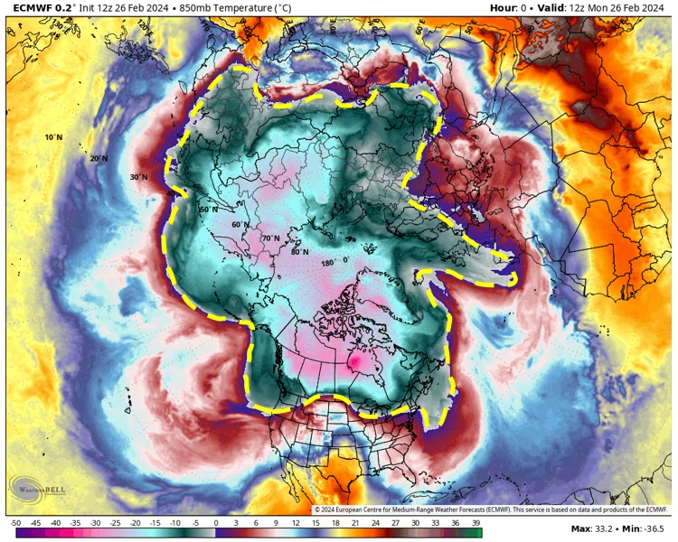
Temperatures about a mile above the surface of Earth on Monday. The yellow dashed line approximately encompasses the Northern Hemisphere cold pool. (WeatherBell)
The amount of cold air above the Northern Hemisphere this winter is near a record low, an unambiguous signal of the planet’s warming climate, according to a new analysis of 76 years of temperature data from about a mile above the ground.
The depleted cold-air supply means blasts of Arctic air generally lack the vigor of the past, while incursions of unusually mild weather — such as the one swelling over the central United States now — can be more frequent and intense.
The cold-air supply in the Northern Hemisphere is being evaluated using temperature data from about 5,000 feet high in the atmosphere. For about a decade, Jonathan Martin, a professor of meteorology at the University of Wisconsin, has analyzed the size of the cold pool at this level — or the area of the hemisphere covered by temperatures at or below 23 degrees (minus-5 Celsius). This winter’s cold pool will finish the winter as the second-smallest on record, Martin said.
“The climate continues to stay at the same pace of warming that it’s been at for the last 20 years,” Martin said. “The hemisphere is showing us in the wintertime, unequivocally, that the globe is warming up.”
| RANK | WINTER | DEPARTURE FROM AVERAGE (MILLIONS OF SQUARE KILOMETERS) |
|---|---|---|
| 1 | 2014-15 | −4.03 |
| 2 | 2023-24 | −3.29 |
| 3 | 2013-14 | −3.17 |
| 4 | 2003-04 | −2.83 |
| 5 | 2019-20 | −2.78 |
| 6 | 1997-98 | −2.72 |
| 7 | 2008-09 | −2.71 |
| 8 | 2006-07 | −2.66 |
| 9 | 2015-16 | −2.42 |
| 10 | 2020-21 | −2.22 |
2023-2024 data through Feb. 25. Source: Jonathan Martin, University of Wisconsin DAN STILLMAN / THE WASHINGTON POST
This winter’s shrinking supply of cold air in the atmosphere has coincided with what is probably to be one of the warmest winters on record. Many locations in the United States are on track for a record-warm winter as temperatures soar to near and above 30 degrees warmer than normal in the season’s final days. On Monday, Dallas hit a record high of 93 degrees, while Minneapolis reached 65 — 32 degrees above average. Chicago could reach the upper 70s on Tuesday, a February record.
Globally, more than 200 countries have seen record warmth this week, according to weather historian Maximiliano Herrera. January was the eighth consecutive month to register as that month’s warmest on record, while 2023 was Earth’s warmest year on record for both the land and oceans.
Some who are skeptical that the climate is warming claim that surface temperatures are rising because of urbanization, changes in sensor location and other factors they say taint the data. While scientists are aware of such influences, and adjust surface data accordingly using methods that have been verified by peer-reviewed research, Martin says the validity of upper-air data is even more difficult to refute.
“These measurements are completely uncontaminated by any of that urbanization,” Martin said. “So if you get a signal [higher up in the atmosphere,] you can be pretty sure that that’s a really robust signal, and it’s got none of those limitations [of] surface-based measurements.”
The year-to-year fluctuations in the size of the cold pool also appear to be unrelated to El Niño, according to Martin. El Niño is a naturally occurring, periodic warming of the ocean surface in the central and eastern Pacific, which scientists say has contributed to extreme surface warmth during the past year.

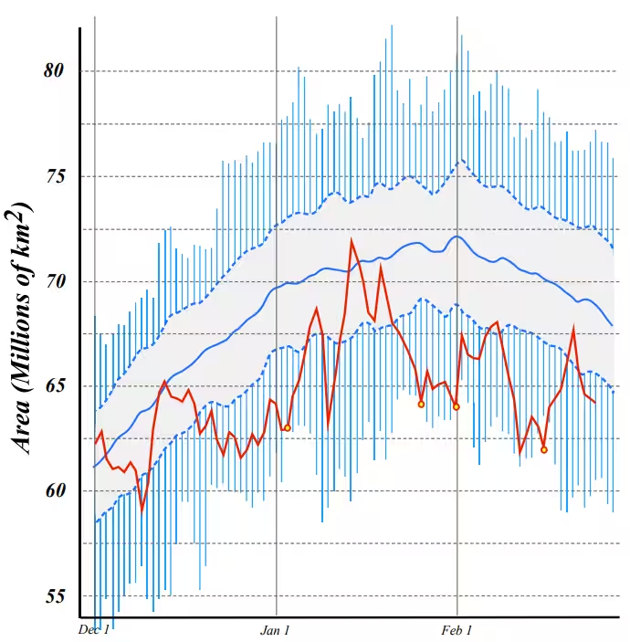
The thick red line represents the daily size of the Northern Hemisphere’s cold pool this winter, while the thick blue line shows the cold pool’s average daily size over the past 76 years. (Jonathan Martin/University of Wisconsin)
Martin calculates the size of the Northern Hemisphere cold pool for each day of winter compared with the average for that day going back to the winter of 1948-1949, when weather balloons started to consistently collect upper-air temperature data. From that, he ranks each winter season (Dec. 1 to Feb. 28) by its average cold-pool size.
Only the 2014-2015 winter saw a smaller cold pool than the current winter. Still, the cold pool reached a record small size on four days this winter which Martin said was “pretty unbelievable.”
Even when the cold pool contracts, it doesn’t mean mild weather will occur everywhere in the Northern Hemisphere, Martin stressed. When the cold pool shrank to a record low in 2014-2015, the United States experienced an extended period of bitter cold.
“So it really points out how regional our own impressions of the winter can be, and how different that can be from the hemisphere’s perspective,” Martin said.
The cold pool decreased to what Martin defines as a warm extreme (two standard deviations smaller than average) on 15 days this winter, while reaching a cold extreme (two standard deviations larger than average) on no days. The last cold extreme occurred in February 1994, making this the 29th straight winter with no cold extremes.
The dominance of upper-air warm extremes is consistent with heat records outpacing cold records. In the United States, for example, there have been nearly 8,000 warm-weather records set this winter, compared to around 2,300 for cold weather.
Jason Samenow contributed to this report.

By Dan Stillman Dan Stillman is a meteorologist and editor for the Capital Weather Gang. He earned an M.S. in Meteorology from Texas A&M University, and a B.S. in Atmospheric, Oceanic and Space Sciences from the University of Michigan. Twitter
Here are more “ET’s” recorded from around the planet the last couple of days, their consequences, and some extreme temperature outlooks, as well as any extreme precipitation reports:
Here is More Climate News from Thursday:
(As usual, this will be a fluid post in which more information gets added during the day as it crosses my radar, crediting all who have put it on-line. Items will be archived on this site for posterity. In most instances click on the pictures of each tweet to see each article. The most noteworthy items will be listed first.)