The main purpose of this ongoing blog will be to track planetary extreme, or record temperatures related to climate change. Any reports I see of ETs will be listed below the main topic of the day. I’ll refer to extreme or record temperatures as ETs (not extraterrestrials).😉
Main Topic: Fall Drought for Most of the U.S.
Dear Diary. October 2024 was the 2nd warmest October on record next to October 1963. So far, Fall 2024 has been the warmest fall since climatology from temperature measurements became reliable for the U.S. in 1895:
All of this climate change related warmth has produced an almost instantaneous drought:

So, what are the nuts and bolts behind this dryness, which could hinder agriculture greatly if not alleviated this winter? For those answers here is a recent Washington Post article:
https://www.washingtonpost.com/weather/2024/11/15/us-drought-conditions-maps-rain
Why the U.S. has gotten so dry, so fast — and what could reverse it
It may sound counterintuitive, but this year’s hyperactive hurricane season may have helped fuel the drought across the United States.

Low water levels at the Wanaque Reservoir in Ringwood, N.J. (Ted Shaffrey/AP)

By Ben Noll
November 15, 2024 at 6:00 a.m. EST
The United States has been like a patch of drought in an otherwise waterlogged world over the past several months. And it may take flooding rainfall to reverse the long-standing dryness.
During October, about 72 percent of the planet experienced above average amounts of atmospheric moisture — a trend toward more water vapor in the atmosphere that’s consistent with a warming world. There was apocalyptic flooding in Spain, a powerful typhoon in Taiwan and Hurricane Milton in Florida. Hurricane Helene — which broke records for moisture content across six states — was also a good example of what happens when storms harness extra moisture and then rainfall is more destructive.
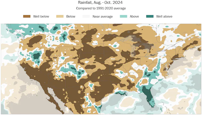
So why, might you ask, did parts of 40 states experience well below normal rainfall from August through October? And how much rain will be required to break the dry trend?
The answer might surprise you. And it’s at least partly connected to this year’s hyperactive hurricane season.

Well-below normal rainfall affected parts of 40 states from August through October, contributing to record levels of geographical coverage of dryness and drought. Date source: ECMWF/ERA5 (Ben Noll/The Washington Post)
The inner workings of the drought
It may sound counterintuitive, but this year’s hyperactive hurricane season may have helped fuel the drought across the United States.
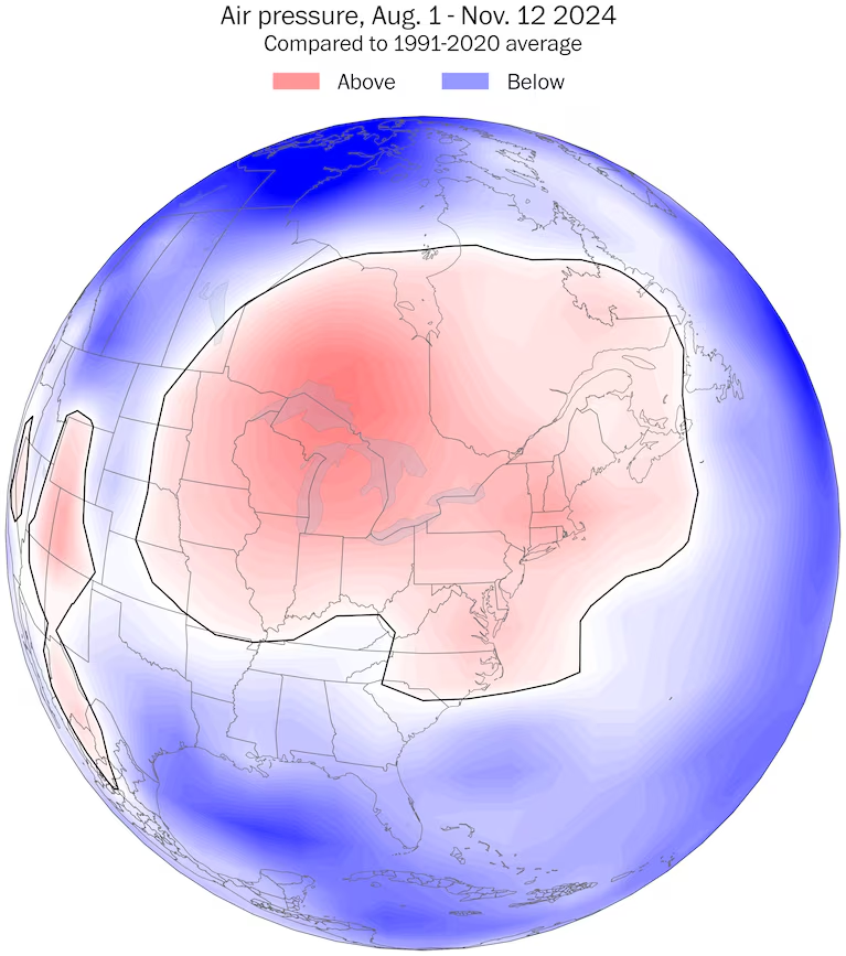
Patterns of low pressure have spanned the tropical Atlantic Ocean, festering over the top of marine heat-wave-affected waters, which are becoming more common in a warming world. The opposite pattern — one of abundant high pressure — has recently covered the northern tier of states, shielding them from the wrath of hurricanes like Helene and Milton.
The atmosphere strives to equalize pressure and temperature differences. As a result, weather systems transport heat from the equator toward the poles. But in recent months, an atmospheric block of high pressure — like a stop sign — has been anchored over the country, preventing moisture from streaming north.

An atmospheric stop sign of high pressure has been anchored over the Northeast and Midwest since Aug. 2024, preventing moisture plumes from reaching the north. (Ben Noll/Data source: NOAA)
These patterns ebb and flow and the drought will eventually break — but the level of rainfall needed to break it is substantial.
Wide-ranging drought impacts
Droughts take a long time to build and a long time to ease, meaning the impact of the 2024 U.S. drought won’t be erased overnight and could easily linger into 2025.
A record-breaking 87 percent of the United States was covered in abnormally dry or drought conditions as of Nov. 5., according to the U.S. Drought Monitor, followed by a reduction to just under 83 percent on Nov. 12.
The table below shows the percent area in U.S. drought monitor categories over the past four weeks.
| Week | No Drought | Abnormally Dry | Moderate Drought | Severe Drought | Extreme Drought | Exceptional Drought |
|---|---|---|---|---|---|---|
| Nov. 12 | 17.13% | 33.03% | 29.32% | 15.59% | 4.25% | 0.68% |
| Nov. 5 | 12.22% | 35.89% | 30.15% | 17.01% | 4.13% | 0.60% |
| Oct. 29 | 12.84% | 33.08% | 26.50% | 21.06% | 5.89% | 0.63% |
| Oct. 22 | 20.67% | 29.37% | 29.96% | 14.95% | 4.43% | 0.63% |
More than 237 million people in the United States were experiencing abnormally dry or drought conditions — in other words, more than seven out of 10 Americans.
But drought is more than just numbers. It has real, tangible effects on people’s lives and livelihoods, like farmers harvesting drought-stricken fields or water supply sources running low. As of mid-November, 64 percent of corn production areas in the United States were experiencing a drought, with local reports of a meager harvest in Ohio.
In New York City, for example, reservoir levels have dipped to 61 percent of capacity — typically, levels are around 79 percent this time of the year. New York City declared a drought watch in early November, following its driest month on record since records began in 1869, 155 years ago.
Dry, windy conditions exacerbated wildfire activity in and around the city over the past week, with the Jennings Creek Fire in Orange County, New York, of greatest concern after spreading to 5,000 acres.
The National Oceanic and Atmospheric Administration’s Storm Prediction Center has continuously flagged elevated fire danger across the same region with gusty winds,humidity levels more typical of Southern California and little rain in sight.
And if any rain-bearing weather systems fail to take a chunk out of the deep deficits this winter, water woes may grow into 2025.
The seasonal snowfall outlook suggests there is some reason for concern that dryness may continue, particularly across southern and eastern states.
In the meantime, Mother Nature will continue to throw up atmospheric stop signs — but the green light for rain is desperately needed.
How much rain is needed to break the drought
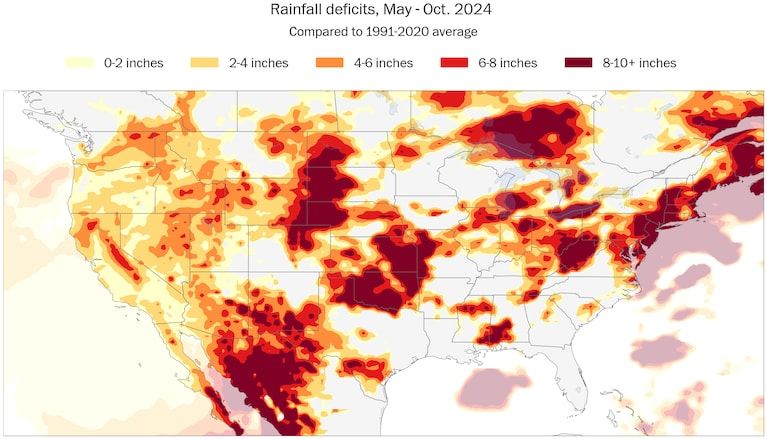
More than 30 states experienced rainfall deficits of more than eight inches over the last six months, extending from as far west as Nevada to as far east as Maine. The rainfall deficits were calculated with respect to historical averages from May through October.
In many places, the deficit is equivalent to two to four months’ worth of rain, something that would typically only fall amid a flooding rain event. However, breaking a drought with a flood isn’t an ideal scenario.

From May through October, more than 30 states experienced rainfall deficits of greater than 8 inches — from Nevada in the west to Maine in the east. Data source: ECMWF/ERA5. (Ben Noll/The Washington Post)
Gentler, sustained rainfall would be much more beneficial, not just to avoid the potentially destructive impacts of a flood, but because lighter rain would stand a better chance of being absorbed into the soil, rather than running off across the dry, cracked ground.
Over the next 10 days, some rain is forecast in drought-stricken areas of the country, like the Plains and Midwest, but much more will be needed.

By Ben Noll Ben Noll is a meteorologist with a passion for communicating extreme weather and climate trends. He has experience working with data and creating weather graphics on a supercomputer, developing meteorological services in the Pacific Islands, and short, medium, and long-range weather prediction. Follow on X @BenNollWeather
Here are more “ETs” recorded from around the planet the last couple of days, their consequences, and some extreme temperature outlooks, as well as any extreme precipitation reports:
Here is more brand-new October/November 2024 climatology (More can be found on each past archived daily November post.):
Here is More Climate News from Saturday:
(As usual, this will be a fluid post in which more information gets added during the day as it crosses my radar, crediting all who have put it on-line. Items will be archived on this site for posterity. In most instances click on the pictures of each tweet to see each article. The most noteworthy items will be listed first.)