The main purpose of this ongoing blog will be to track planetary extreme, or record temperatures related to climate change. Any reports I see of ETs will be listed below the main topic of the day. I’ll refer to extreme or record temperatures as ETs (not extraterrestrials).😉
Main Topic: Climate Change Behind Snowless Decembers
Dear Diary. Last winter was the warmest winter for the lower 48 states in history. Not one flake of snow fell where I live in Atlanta, which was a first in my book since living here since the 1970s. Usually, we will have accumulating snow amounting to a couple of inches once a year with several days in which there are flurries. Atlanta is not the only location that is lacking typical snow. Bah humbug! Places that once had a decent shot of a white Christmas can no longer expect flakes because of climate change.
Here is a report from Washington D.C. reporting on a noticeable change there:
https://www.washingtonpost.com/weather/2024/12/16/dc-declining-december-snow-climate
Why it has essentially stopped snowing in D.C. during December
Climate change seems to be melting away our snow chances.
December 16, 2024

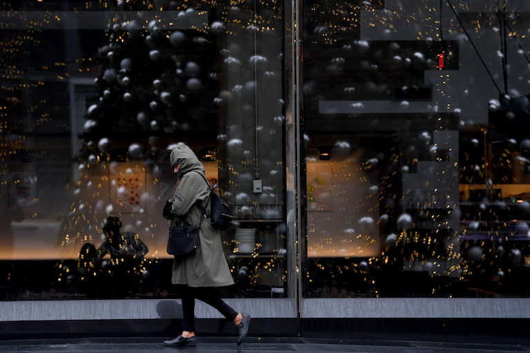
The Christmas tree at City Center in D.C. is reflected in the window of a restaurant during a cold and rainy December day. (Katherine Frey/The Washington Post)
By Ian Livingston and Jason Samenow
It doesn’t seem to snow much in D.C. anymore during December, or at least like it used to. Climate change seems to be melting away the city’s snow chances.
The lack of snow is dashing white Christmas hopes and is yet another symptom of the effects of human-caused warming in the Washington region.
Over the past six Decembers combined, only 0.5 inches of snow has accumulated in the District. The average December snowfall each year, based on the period 1991 to 2020, is 1.7 inches. If this December turns out to be snowless, which is possible, the District will clinch its least snowy seven-year stretch of Decembers on record.
The table below lists the amounts of snow received over the last seven Decembers:
| Year | Snow amount (inches) |
|---|---|
| 2024 (so far) | 0 |
| 2023 | 0.1 |
| 2022 | Trace* |
| 2021 | 0 |
| 2020 | Trace* |
| 2019 | 0.4 |
| 2018 | 0 |
| 2017 | 1.9 |
* A trace signals snowflakes were observed but no accumulation occurred.
Snowfall hasn’t reached or exceeded the December norm since 2017.
The prospect for a snowless December this year follows the District’s warmest November on record and comes during what is expected to be the warmest year on record for the planet and probably for the District as well.

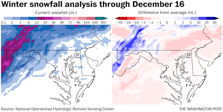
Snowfall this winter is running a bit below average in most of the local region. Above average snow has fallen in the mountains. (The Washington Post)
A declining cold air supply
Snow requires cold air, which has been lacking in many recent Decembers. Five of the 10 warmest Decembers in D.C. have occurred since 2010 in records dating to 1871.
The District’s average December temperature in recent decades is simply not hospitable to snow. It’s now in the low 40s, whereas it was in the mid-30s in the late 1800s.
As December temperatures have climbed, snowfall has plummeted. The average December snowfall in the late 1800s and early 1900s was about 4 inches. Now, it’s less than 2 inches.
In response to the warming, the season’s first snowfall of the season is trending later. A century ago, the District’s first snowfall of at least an inch would fall in mid-December, on average. Now, it comes around the first week of January.
Even before human-caused climate change started increasing temperatures in the Washington region, its typical winter climate only marginally supported snowfall. Every increment of warming in recent decades has pushed the District toward the wetter side of the rain-snow line that often sets up over the region.
The snowfall trends observed in the District during December also apply to other locations in the region. But they haven’t been quite as pronounced in colder areas well to the north and west, where temperatures are still sufficiently cold to support snow during the month.
Even in the District, the long-term shift toward less snow can be overwhelmed by a blockbuster storm. During the region’s snowiest winter on record, in 2009-2010, the Dec. 18-19 “Snowpocalypse” storm unloaded 16.4 inches and brought the city its snowiest December. There was a white Christmas that December, but there hasn’t been one since.
Any snow hopes ahead?
This December has actually been somewhat colder than normal so far (though what’s now considered normal is considerably milder than in the past). Despite the chill, we’re in a pattern that tends to be dry when it’s cold and just warm enough for rain when there’s a thaw.
Computer model projections are not promising for meaningful snowfall the rest of this month. Dry air will probably follow in the wake of a cold shot expected between Thursday and early next week. Then the weather pattern is predicted to turn atypically mild between Christmas and New Year’s.

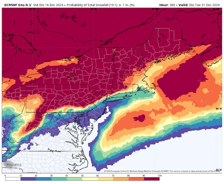
Odds of one inch or more snow through the rest of the month on the European weather model. (weatherbell.com)
Computer models project less than a 10 percent chance of more than an inch of snow through the end of the month east of Interstate 95 and just a 10 to 20 percent chance to the north and west.
The winter outlook from the National Weather Service favors warmer than normal weather in the Mid-Atlantic, while the Capital Weather Gang’s own outlook offers a bit more hope for snow lovers in January and February.

By Ian LivingstonIan Livingston is a forecaster/photographer and information lead for the Capital Weather Gang. By day, Ian is a defense and national security researcher at a D.C. think tank.follow on X@islivingston

By Jason Samenow Jason Samenow is The Washington Post’s weather editor and Capital Weather Gang’s chief meteorologist. He earned a master’s degree in atmospheric science and spent 10 years as a climate change science analyst for the U.S. government. He holds the Digital Seal of Approval from the National Weather Association. Follow on X@capitalweather
Here are more “ETs” recorded from around the planet the last couple of days, their consequences, and some extreme temperature outlooks, as well as any extreme precipitation reports:
Here is More Climate News from Wednesday:
(As usual, this will be a fluid post in which more information gets added during the day as it crosses my radar, crediting all who have put it on-line. Items will be archived on this site for posterity. In most instances click on the pictures of each tweet to see each article. The most noteworthy items will be listed first.)
Big applause for CCL virtual climate conference!
Have COP fall in line.
All conferences be virtual
AND ALL BOOKS be virtual
Then scientists will be walking the talk…