The main purpose of this ongoing blog is to track planetary extreme, or record temperatures related to climate change. Any reports I see of ETs will be listed below the main topic of the day and are archived on each prior post. I’ll refer to extreme or temperatures as ETs (not extraterrestrials).😉
Main Topic: Update on U.S. Arctic Blast Dubbed Chione
Dear Diary. The writing is now on the proverbial wall that an Arctic blast of cold air will affect most of the United States starting this weekend. I dubbed the cold outbreak Chione for the Greek goddess of snow as described here:
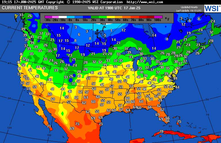
Today temperatures are notably mild from coast to coast with Chione just beginning to make its presence felt in Montana through the Dakotas:
It now appears that Chione will lie squarely in my CAT3 major dangerous ranking because it will produce widespread dangerous chill with some daily records, but will it achieve historic CAT4 status?
While being the coldest Arctic outbreak in several years, I doubt that we will see more than a few all-time records from the thing, if any. Still, one consequence of Arctic air penetrating as far south as Florida will be a storm along the Gulf Coast, which in itself will be historic in nature depending upon snow and ice amounts.
Here is the latest GFS deterministic forecast as of 12Z Friday:
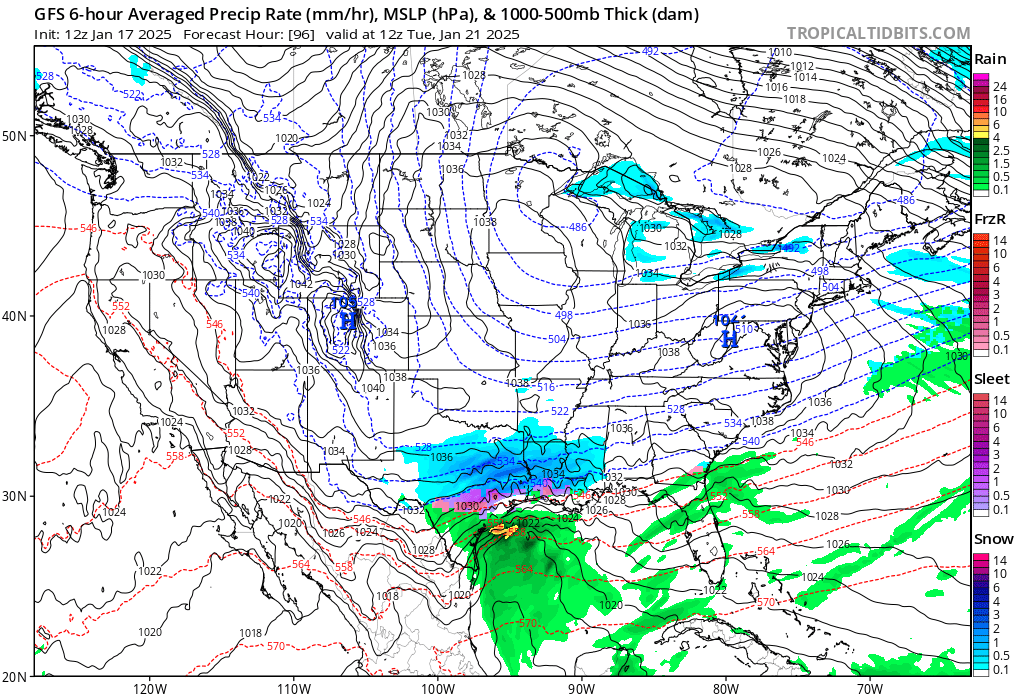
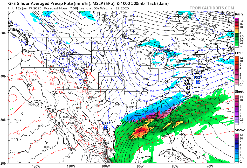
The GFS has trended a little farther north since Thursday bringing snow as far north as Birmingham and my hometown of Atlanta. Gulf Coast snow events are quite rare, even during the colder climate of the 20th century. This might be one of the last times we see snow and ice as far south as New Orleans and Tallahassee.
Here are the latest details on Chione from the Washington Post (for some videos and graphics that I did not repost, hit the following link):
120 million people could experience subzero temps soon. Where the cold will be worst.
Around 30 states and nearly 50 million people could experience temperatures below minus-10 degrees.
Friday 1/17/2025 at 7:14 a.m. EST
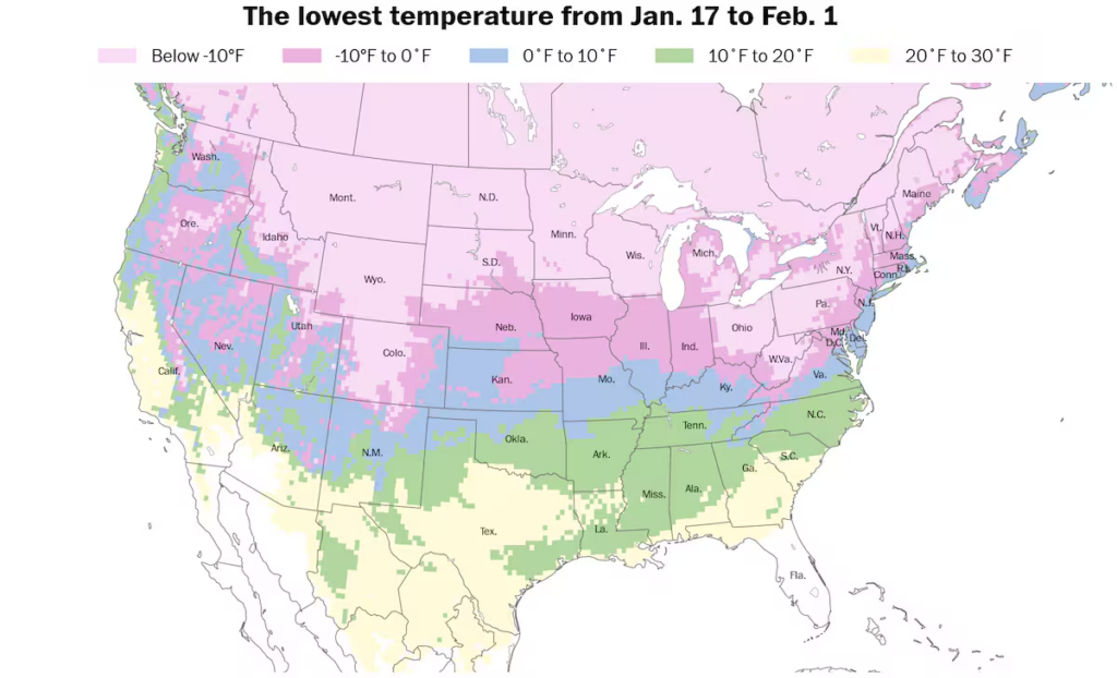
Around 30 states and 50 million people are forecast to experience temperatures lower than minus-10 degrees over the next two weeks. (Ben Noll/Data source: ECMWF)

By Ben Noll
Much of the country is in for widespread and dangerously cold temperatures beginning this weekend — and lasting through much of next week — as a lobe of the polar vortex over northern Greenland is projected to swirl more than 3,000 miles south toward the United States.
More than 120 million people live in a zone that will experience subzero temperatures — affecting more than a third of people living in the United States — while around 30 states and nearly 50 million people could experience temperatures below minus-10 degrees. The dangerous wind chills and severe levels of cold will drive a risk of hypothermia and frostbite. The plummeting temperatures can cause frozen and bursting pipes and threaten the power grid. The cold will also be a danger to pets and livestock.
The polar pattern will also lead to accumulating snow and slippery roads in the Mid-Atlantic and Northeast on Sunday and the potential for a wintry mix in the Deep South early next week.
By Monday, extremely cold air will reach as far south as the Gulf Coast, where it will clash with warmer, oceanic air. As a result, wintry precipitation is possible from Texas to the Carolinas from Monday night into Wednesday.
Even parts of northern Florida could experience snow or ice amid the unusual pattern.
The coldest air of winter (so far)
The coldest air of the winter season, at least so far, will cascade down the eastern slopes of the Rocky Mountains over the weekend, reaching the Eastern Seaboard on Monday.
This will set the stage for widespread frigid conditions that will rival the notorious polar vortex episode of winter 2014.
During January 2014, over 140 million people in the United States experienced subzero temperatures. Over the next two weeks of this year, around 120 million people are forecast to experience that level of cold.
The polar vortex, a ring of frigid air typically located near the North Pole, will become stretched and displaced through early next week, carving a path across the central and eastern United States.
Temperatures will dip dangerously low, reaching minus-20 to minus-30 in parts of North Dakota, Minnesota, Wisconsin and Michigan on Monday and Tuesday morning — enough to cause frostbite in 10 to 20 minutes on exposed skin.
Areas from Illinois to Maine will experience low temperatures in the minus-10 to minus-20 range on Tuesday and Wednesday morning.
Record-low temperatures will be possible in places such as Pittsburgh; Morgantown, West Virginia; and Binghamton, New York.
When the wind is factored in, wind chill values could reach minus-40 in North Dakota and northern Minnesota on Monday. On Tuesday, values could reach minus-30 in Minnesota, as well as Wisconsin and Michigan — and minus-20 in Michigan, Ohio, western Pennsylvania, West Virginia, western New York and Ontario, Canada, on Wednesday.
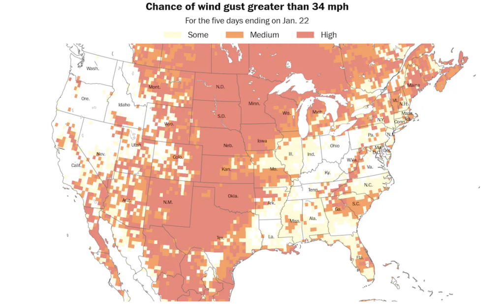
Many states will face gusty winds over the next several days, contributing to a dangerous wind chill. (Ben Noll/Data source: ECMWF)
Any drop in temperatures to this level can be dangerous and deadly, and associated risks should be taken seriously, especially for vulnerable populations. Pets should also be protected from the cold.
The extreme temperatures could test the country’s stretched power grid and cause water pipes to freeze and burst. Following a deadly polar plunge in February 2021, Texas bulked up its grid by adding giant batteries, windmills and solar panels to better weather storms and chills.
When the frigid air reaches the United States next week, temperatures in Nuuk, Greenland, will be warmer than in many areas across the United States.
How long will the cold last?
The polar vortex lobe will retreat into Canada by Friday. While it will still be cold into next weekend, the chill will be less intense compared to earlier in the week.
During late January and February, the most unusually cold air may shift into Canada and the northwestern United States.
This could allow more moisture to surge northward, helping to form an active storm track across the country — driven by a strong jet stream pattern from the southern states to the East Coast.
The jet stream is a ribbon of strong winds in the upper atmosphere along which storms track.
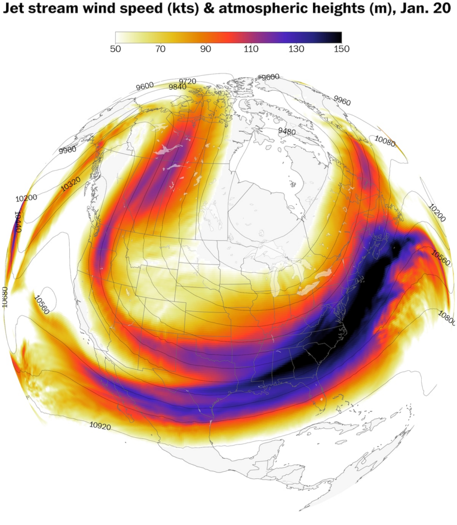
An active jet stream pattern will fuel several storms across the country through the end of January. (Ben Noll/Data source: ECMWF)
Long-range guidance suggests February will be snowier than normal from the Northwest to the Northeast.
In other words, prepare for plenty of harsh winter weather in the weeks ahead.
Where and when snow and ice may fall
Two substantial storm systems may form as the polar vortex moves south.
The first system is expected to form near the Mid-Atlantic coast on Sunday, bringing accumulating snow from Virginia to Maine.
Snow accumulations of 1 to 3 inches will probably be widespread from Washington, D.C., to Boston, including in Baltimore, Philadelphia and New York City — although it’s also possible that 3 to 6 inches could fall in parts of this corridor.
The amounts depend on how close the storm forms to the coast. Recent forecast trends have brought the storm closer to the coast, which would be conducive to higher snow totals.
Roads will probably be slippery and snow-covered in this densely populated region from Sunday into early Monday.
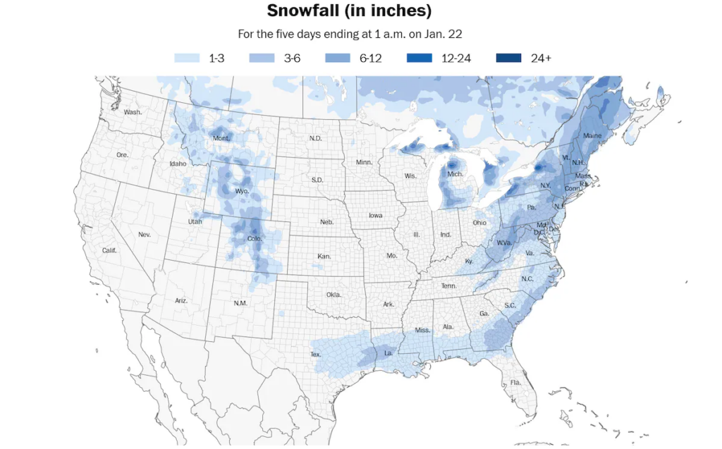
Accumulating snow is expected in the Mid-Atlantic, Northeast, Deep South and Southeast through Jan. 21. (Ben Noll/Data source: NOAA)
The second storm may bring snow and ice from Texas to the Carolinas from Monday into Wednesday — and could include Florida.
Just how far south the coldest air pushes will determine where snow and ice will fall.
In one scenario, frigid, dry air associated with the polar vortex will confine the storm activity to a narrow corridor in the Deep South. In another scenario, more widespread moisture from the Gulf of Mexico would spread wintry impacts across a wider area.
Cities that should be aware of the potential for unusual winter weather early next week include Houston and San Antonio; Lafayette and New Orleans in Louisiana; Hattiesburg, Mississippi; Mobile and Montgomery in Alabama; Albany and Savannah in Georgia; Tallahassee and Jacksonville in Florida; Charleston and Myrtle Beach in South Carolina; and Wilmington, North Carolina.
In a worst-case scenario, travel could grind to a halt across the Deep South. A cycle of melting and refreezing could develop following the storm, leading to days of icy conditions after the storm passes.
The atmospheric puzzle pieces that will help generate the storm are currently over the North Pacific Ocean and Greenland. When they reach Canada and the United States over the weekend, the forecast for the southern storm should become clearer.

By Ben Noll Ben Noll is a meteorologist with a passion for communicating the ‘why behind the weather’, extreme events and climate trends. He has extensive experience working with meteorological data and creating weather graphics on a supercomputer, developing meteorological services in the Pacific Islands, and short, medium, and long-range weather prediction. Follow on X@BenNollWeather
Here are more “ETs” recorded from around the planet the last couple of days, their consequences, and some extreme temperature outlooks, as well as any extreme precipitation reports:
Here is More Climate News from Friday:
(As usual, this will be a fluid post in which more information gets added during the day as it crosses my radar, crediting all who have put it on-line. Items will be archived on this site for posterity. In most instances click on the pictures of each tweet to see each article. The most noteworthy items will be listed first.)