The main purpose of this ongoing blog will be to track global extreme, or record temperatures related to climate change. Any reports I see of ETs will be listed below the main topic of the day. I’ll refer to extreme or record temperatures as ETs (not extraterrestrials). 😉
Main Topic: Burst of Record Warmth to Start Out February Across the Southern U.S.
Dear Diary. After a relatively cold January, the atmosphere affected by increasing carbon pollution has quickly warmed across most of the U.S. A regime that brought us an extreme cold and snow event across the Gulf Coast in January has been replaced by record warmth in whiplash fashion. As has happened many times since about 1980, crazy bursts of record warmth have been occurring across the country and world, and this one in February is no exception:
Meteorologically, a heat dome has quickly built over the South, which will be slow to break down this week:
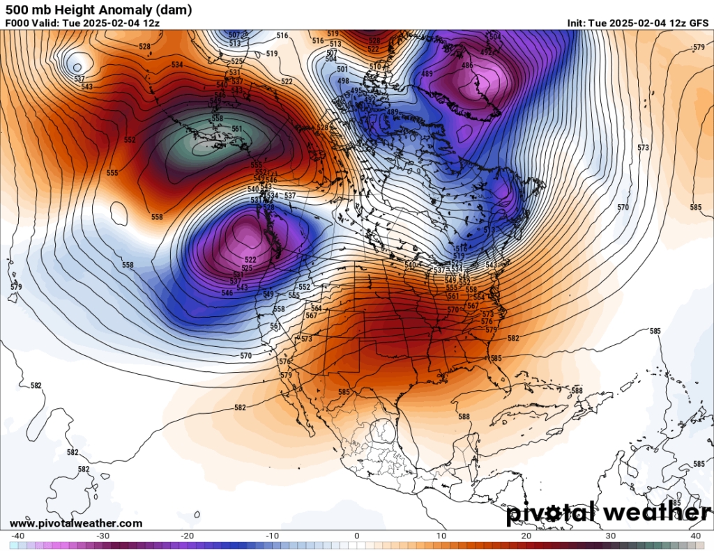
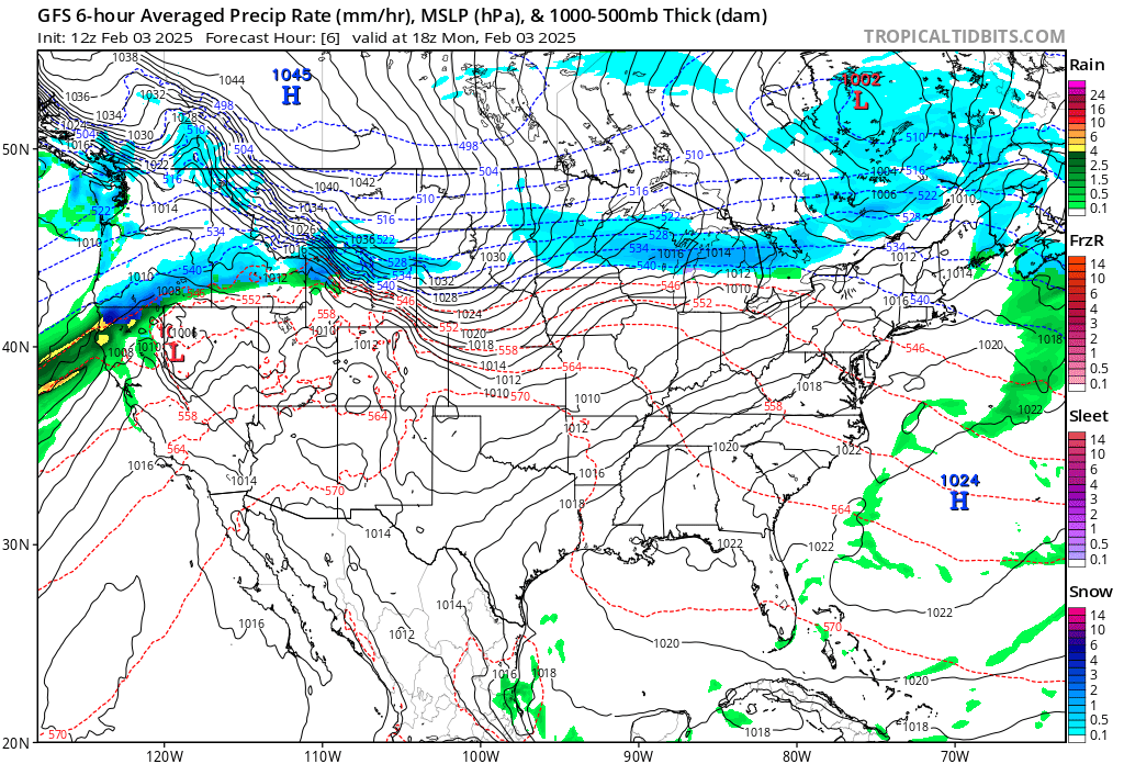
At the surface looking at pressure and thickness patterns, indeed it was very warm to start out on Monday February 3rd:
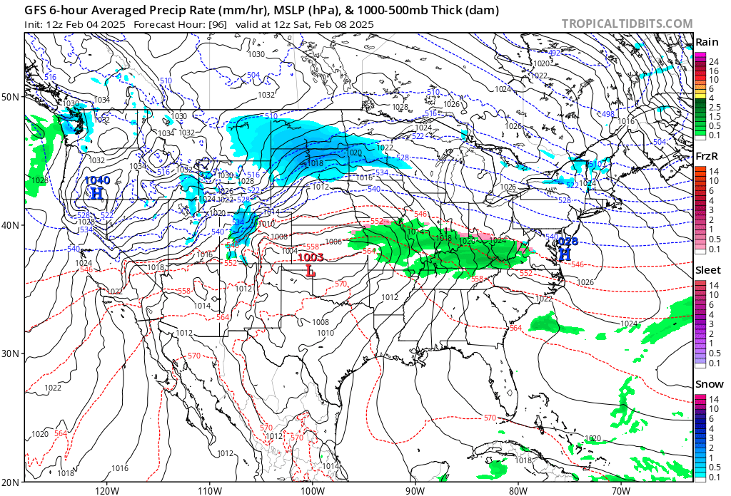
Record warmth will continue across the south through Saturday before a front finally surges southward next week:
Here are more details from the Washington Post:
It’s about to feel like spring for millions in the U.S. Find out where and for how long.
You can start February wearing shorts in much of the United States. About 140 million people may experience temperatures over 70 degrees.
January 31, 2025
Over 200 million people across more than 30 states could experience temperatures higher than 60 degrees over the next week. Temperatures reaching 70 degrees will return to many states, with a few topping 80. (Ben Noll/Data source: ECMWF)

By Ben Noll
It’s time to break out the T-shirts and shorts once again — at least for the next week.
In stark contrast to recent frigid weather dominated by a displaced polar vortex, February will start on an entirely different and warmer note across much of the United States.
After 100 million people across the country experienced subzero temperatures during January, more than 200 million people in about 30 states can now expect temperatures to exceed 60 degrees over the next two weeks.
Around 140 million people may experience temperatures greater than 70 degrees.
It will be an opportunity for many people to open their windows and welcome fresh, warmer air — and for some, it may require dipping into their spring wardrobe.
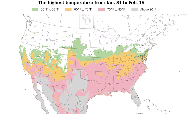
The map below highlights the states that are on what we’ll call “shorts watch” — places where the temperature is forecast to rise into the upper 60s or higher in the next two weeks.
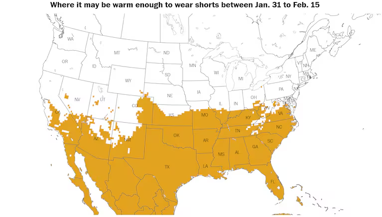
It may be warm enough to wear shorts in more than 25 states over the next week due to a springlike weather pattern. (Ben Noll/Data source: ECMWF)
The abrupt pattern change is tied to a change in the jet stream, which will blow in a linear, west-to-east fashion across the country over the next week to 10 days.
This will transport mild, Pacific Ocean air into the United States — from an ocean that continues to run warmer than average.
Where and when it will be warmest
There will be three main waves of warm air over the next week.
The rest of this week
The first will be felt across large parts of the central and eastern states on Friday.
Temperatures will reach the 70s and 80s from Florida to the Carolinas, making it the warmest day in a month or two for areas that experienced a record-breaking snowstorm just 10 days ago. High temperatures will be more typical of April than January.
Meanwhile, 60-degree temperatures will reach as far north as southern Ohio, a state where January average temperatures were lower than those of Anchorage.
Late weekend into early next week
The second surge of unusual warmth will build across the northern Plains on Saturday, spreading eastward on Sunday and Monday.
The 50-degree line could reach southern Minnesota on Sunday, with widespread 60s and 70s across the central and southern states — along with some 80s.
Little Rock, a place that has been unusually snowy this winter, may reach the 70s all week. Wednesday’s record high of 75 degrees could be challenged.
On Tuesday and Wednesday, the area from Denver to Oklahoma City could experience its warmest conditions since late October, reaching the 70s and 80s. High temperature records of 78 and 77 in Oklahoma City may be broken on Tuesday and Wednesday.
Parts of western Texas could even reach 90 degrees, more than 20 degrees above average for the time of year.
The state with the most unusually cold air during January, West Virginia, will also experience an early springlike day on Monday, with temperatures in the 50s and 60s.
Deeper into next week
The warm conditions will continue across the South on Tuesday and Wednesday, with Atlanta probably reaching into the 70s most of the week, making it feel more like April.
The unseasonable midweek warmth could spread north to St. Louis, where high temperature records near 70 degrees could be challenged on Wednesday and/or Thursday.
Although there is some uncertainty about how far north the warm air will extend, parts of Illinois, Indiana and Ohio could have their warmest conditions in several months on Wednesday and/or Thursday, reaching into the 60s. This includes Chicago, where it hasn’t reached 60 since November.
By Thursday and Friday, the third surge of warmth will spread eastward, with the potential for 70-degree temperatures in the Mid-Atlantic, perhaps as far north as Washington and Baltimore. On Thursday, the record high temperatures for the date are 71 degrees in the nation’s capital and 72 degrees in Baltimore.
A warm front — or a dividing line between advancing warm air and retreating cold air — will form a sharp boundary between warm, springlike temperatures and colder, wintry ones. Areas north of the boundary, along the far northern tier of the country, may face periods of snow and ice late in the week.
Warm conditions could continue in the South next weekend as cooler air gradually spreads across much of the rest of the country.
What’s behind the pattern change
An atmospheric river, like a river in the sky, will make landfall in Northern California this weekend, bringing heavy rain and mountain snow to the Northwest.
This strong weather feature is associated with a particularly strong jet stream, which is forecast to extend across the length of the Pacific Ocean — from near Japan to the western United States.
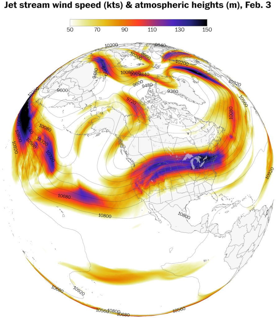
A strong and linear jet stream pattern from the Pacific Ocean will usher milder air into the United States over the next week. (Ben Noll/Data source: ECMWF)
The jet is not just carrying moisture but blowing mild Pacific air deeper into the country.
This is in direct contrast with the loopy, meandering jet stream that caused well-above-average temperatures in Alaska during January, with Anchorage having a warmer average temperature than parts of three dozen states.
A switch toward southerly winds, originating from a warmer-than-average Gulf of Mexico, will add to the unseasonable warmth.
With much of the snow from recent storms having melted and the sun angle gradually getting higher in the sky, there will be little to stop temperatures in the coming days from rising to levels that are more typical of early to mid-spring.
By Ben Noll Ben Noll is a meteorologist with a passion for communicating the ‘why behind the weather,’ extreme events and climate trends. He has extensive experience working with meteorological data and creating weather graphics on a supercomputer, developing meteorological services in the Pacific Islands, and short, medium and long-range weather prediction. follow on X@BenNollWeather
Here are more “ETs” recorded from around the planet the last couple of days, their consequences, and some extreme temperature outlooks, as well as any extreme precipitation reports:
Here is More Climate News from Tuesday:
(As usual, this will be a fluid post in which more information gets added during the day as it crosses my radar, crediting all who have put it on-line. Items will be archived on this site for posterity. In most instances click on the pictures of each tweet to see each article. The most noteworthy items will be listed first.)