Monday August 7th…
Dear diary. Since there won’t be many locations across the U.S. with dangerous heat, I’m going to give a brief meteorology lesson expounding more on the Hudson Bay low and the North Atlantic Oscillation and their ramifications for U.S. weather. Let’s look at the current weather pattern. This chart is valid for midday Tuesday:
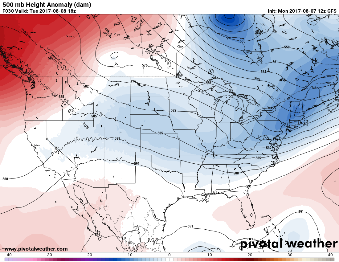
The Hudson Bay low is well established and centered right over Hudson Bay, thus the name. Usually when the Hudson Bay low is present weather systems will rotate around the feature and cool off the lower 48 states. On the above chart we see a cold trough south of the Hudson Bay low that one can pick out from Maine southwest to Kentucky. A weather producing front is in association with that system. There is a smaller low located in southern Saskatchewan that will move into the northern Plains. Both of these systems are caught in the circulation of the Hudson Bay low. You will notice a lot of blue on the chart in the U.S. representing below average 500 Mb heights and thus temps. The only red area of any consequence is in the Pacific Northwest where heat wave #5 is barely hanging on.
When the Hudson Bay low is persistent and strong, as has been the case for more than a week, we usually find the pattern or similar patterns as presented on the above Pivotal Weather chart. The low can get dislodged from Hudson Bay and may reside much further south. Should that be the case weather east of the Rockies in the U.S. gets quite chilly. Usually a phenomenon called the negative phase of the North Atlantic Oscillation leads to a strong Hudson Bay low or vortex. Here is a broader view of height anomalies over North America also valid for Tuesday:
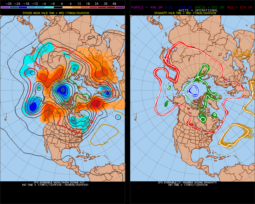
Here we see oranges and reds over Greenland and the north Atlantic representing above average heights and temps, which is the negative phase if the North Atlantic Oscillation (NAO). This ridge is nosing westward trying to connect with another above average height anomaly over Alaska and western Canada forcing the jet stream south aiding to form the Hudson Bay low.
In about 240 hours we see blues over Greenland and the north Atlantic, which is the positive phase of the NAO:

The positive phase of the NAO weakens the Hudson Bay low to the point where it sometimes warms and disappears as is in this forecast case. Once the Hudson Bay low dissipates the jet stream relaxes and moves north leading to warmer weather across the U.S. This is known in met speak as a “pattern change”. We will see if one occurs after the 15th of this month.
O.K. our meteorology lesson is over for today. Here are Tuesday’s forecast maxes:
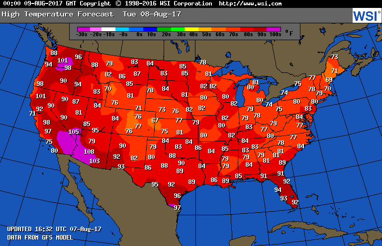
Except for the western third of the U.S., south Texas and Florida, there is just not any dangerous heat. In fact, this chart is amazingly cool for early August. Again, note that most of the dangerous heat is south of that 588 decameter height line east of the Rockies (a rule of thumb I have referred to):

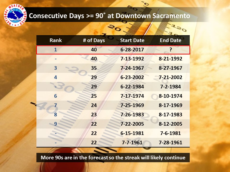
It has definitely remained very hot in interior areas of California. Sacramento should break their record for the number of consecutive days above 90F today:
Here are today’s maxes:

Texas has cooled off substantially after the weekend. Yes, early fall-like reading were very common east of Utah. Sacramento CA did set that record streak for the consecutive number of days at 90F and higher for maxes today.
The Climate Guy
Sunday August 6th…
Dear diary. We are now well into the proverbial dog days of summer. Thankfully, there is no historic heat wave occurring in the U.S. at the present time. In July, according to weather historian Chris Burt, the heat capital of the U.S., Death Valley, did make some historic news now getting the top nod for the highest average monthly temperature of any station in the world:
https://www.wunderground.com/cat6/new-global-record-hottest-single-month-established-death-valley
That figure at Death Valley for July 2017 was 107.24F.
What do we see as a temperature guide for Monday? Here is my usual map:
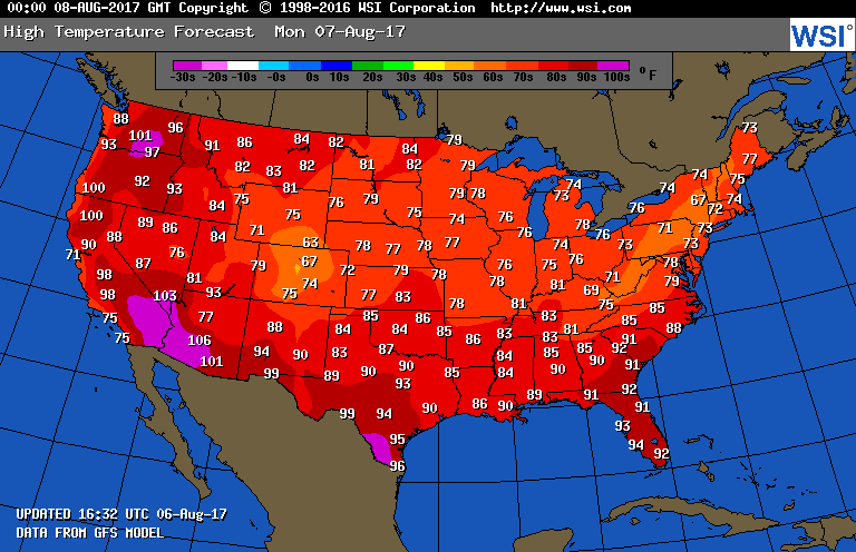 There should not be any earthshattering news heat wise reported across the United States this week.
Wow it has been hot in Miami this summer! Saturday August 5th they set an all-time high minimum of 84F.
Here are Sunday’s maxes:
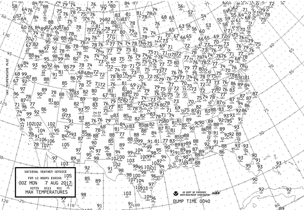
The usual hot locations were above 100F from Texas westward into the deserts of the Southwest. Heat wave #5 is barely hanging on in the Pacific Northwest where smoke from forest fires remains the greatest problem.
The Climate Guy
Saturday August 5th…
Dear diary. It appears like the United States will be blessed without having to deal with any large scale heat waves this month considering current average global warmth. The 5th heat wave, which is occurring in the Pacific Northwest, is waning, but won’t totally end for a few more days. By my count this season the first heat wave was in early June in the East, the second and most significant occurred from mid-late June in the Southwest followed by a third in the same area in early July. A fourth popped up in the Plains and South, but didn’t produce that many records, and this fifth heat wave has resided from northern California into the Pacific Northwest.
Sunday’s forecast maxes will be anything but hot for most of the Plains, Midwest and East:
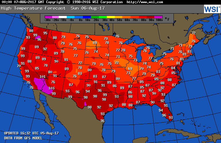
There might be a small smattering of record maxes coming from Washington and Oregon, but the main concern there will be smoke.
As stated yesterday, it will be interesting to see if “The Streak” of 32 consecutive months of more record highs than lows being set across the U.S. breaks this month. The mechanism that might finally do the trick is the Hudson Bay low, which has strengthened over the last month. Disturbances rotating around the thing have ushered in below average temperature air masses deep into the CONUS. By next Friday we see more of the same looking at this 500 millibar height anomaly map (blues represent below average heights and thus temps):

Here are the two meter (near surface) forecast temps in association with the same chart:
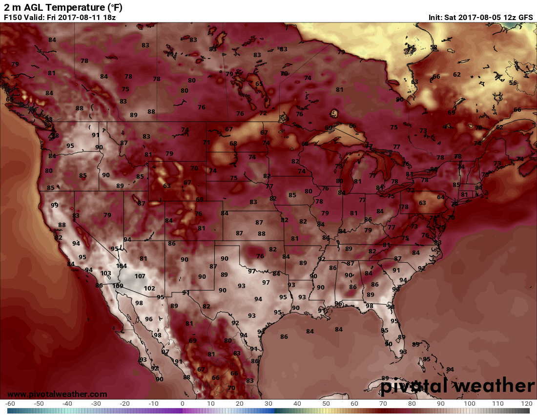
Upon examination, you will find that the above numbers look like those forecast for Sunday. Often the atmosphere for weeks and sometimes months gets stuck in wash, rinse, repeat mode. This time around this is good news for the U.S. Due to the carbon pollution induced global warming trend, though, such patterns like the current one will become more rare, unfortunately… or will they?
I’m convinced that regional climate models will need to incorporate Hudson Bay water temperatures and overall North American geography to come up with better long range forecasts for the CONUS this century. Perhaps the Hudson Bay low, or vortex aloft, has remained strong enough over the last few decades to lead to this temperature pattern on the left (images from @Chigeorge72):
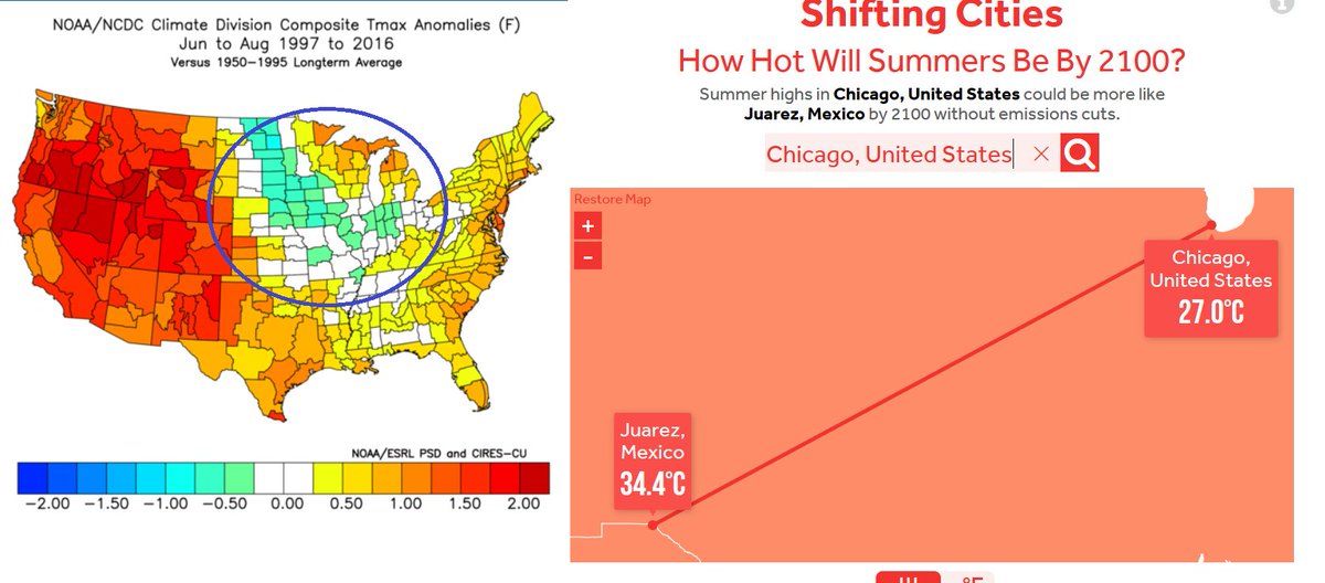
I’ve known about the circled Midwest trend for a while. The Midwest is one of the few areas on the planet that has not been warming much over the last few decades. Will charts such as the one on the right be out to lunch? How much is warming aloft around and north of Hudson Bay interacting with the Hudson Bay vortex to produce colder than average conditions mainly in the Midwest? These questions should be answered by better climate models.
One other note. It does not appear that the heat dome in the Pacific Northwest will be going away anytime soon. This is bad news for people with respiratory problems from Washington northward into British Columbia hoping for some smoke relief from burning wildfires.
Here are today’s maxes. There were a few surprises:
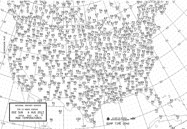
Smoke really cooled Seattle, which only managed to get up to 82F. Dangerous heat spiked much more than expected south of a developing front from Wichita KS southward through Texas where century mark readings were common. It was a great day to get outdoors from Montana through the northern Plains all the way to the East Coast.
To see all 2017 Heat Diary entries click:
https://guyonclimate.com/category/heatdiary2017/
The Climate Guy