Saturday September 14th… Dear Diary. The main purpose of this ongoing blog will be to track United States extreme or record temperatures related to climate change. Any reports I see of ETs will be listed below the main topic of the day. I’ll refer to extreme or record temperatures as ETs (not extraterrestrials).😉
The Rain In Spain Falls…Everywhere
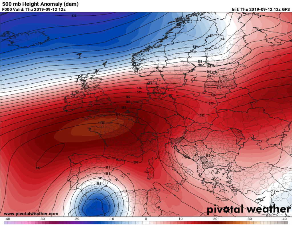
My radar this morning caught some reports that the country of Spain has undergone yet another climate change weather emergency, although this year not from a heat wave leading to a drought and fires, but from a flood a few days ago. I checked the 500 millibar pattern and sure enough a small, cold closed low had developed over northwest Africa south of a giant heat dome centered over western Europe. Stu Ostro, who I worked closely with at the Weather Channel, was one of the first meteorologists I know of to have identified such a marker occurring more frequently around the planet as that of a climate change signature. These “Rex Blocks” are slow to move and frequently produce flooding during the warm season, and even heavy snow during winter. Here is an analysis from 9/12:

Apparently a closed, cutoff from the jet, low developed over Morocco, which funneled Mediterranean moisture into Spain, squeezing out copious amounts of precipitation. A 594+ decameter ridge is quite impressive on the above Pivotal Chart extending eastward into France.
Here is more on this week’s flooding in Spain:
Reprinting the Watcher piece that Bill McKibben links here is what we see:
https://watchers.news/2019/09/12/spain-flood-tornado-september-12-2019/
Worst storm in over a century hits Spain, major floods and tornadoes reported
Posted by Julie Celestial on September 12, 2019 at 16:37 UTC (2 days ago)
Categories: Featured articles, Floods, Severe storms, Tornadoes, Typhoons

A slow-moving storm system pummelled a massive area of Spain, spawning floods, hails, thunderstorms, and tornadoes on September 12, 2019. Torrential rains put Costa Blanca around Benidorm and Alicante under red weather alert and killed two in Valencia region. The storm was described as the worst in more than a century.
Violent weather prompted Spain to brace for further widespread destruction as rains across the southern area were recorded the worst since 1917.
Footages of the river-like floodings went viral online, showing several vehicles being dragged by muddy waters. Fortunately, the cars had no passengers, officials said.
Another video emerged showing the horrifying flash floods triggered by the overflowing of Clariano RIver in Ontinyent municipality, Vall d’Albaida, Valencia province on September 12.
The river burst its banks, causing 40 people to be rescued and 150 others to be promptly evacuated from their residences. Port de Sagunt has also been temporarily closed.
Aside from the Clariano river, the Canyoles river was also swollen, flooding the Bosquet ravine in Moixent.
AEMET, the country’s weather agency, said that 71.8 mm (21.8 inches) of rain fell in Pego in Alicante province, 64.2 mm (2.5 inches) in Fontanars dels Alforins, 54.7 mm (2.1 inches) in Ibiza airport, and 33.4 mm (1.3 inches) in Murcia by 07:00 LT, September 12.
Through the morning of September 11, Ontinyent in the province of Valencia recorded a staggering 277.6 mm (10.93 inches) of rain, making September 12 its wettest day since records began in 1917.
Two fatalities were reported in the region, who were suspected to be a married couple until officials confirmed that they were siblings aged 51 and 61. Further reports stated that the victims’ car was swept away by floods.
Schools were canceled for over 338 000 students in Alicante and Valencia, while all classes in Murcia were suspended.
Aside from heavy rains, mudslides, and flash floods, authorities also issued risk of hails due to thunderstorms. According to reports, wind gusts may reach up to 72 km/h (45 mph) through September 12.
The severe weather conditions also summoned a tornado, as shown in a video posted by Severe Weather Europe. The twister is seen hitting Guardamar del Segura, Alicante on the morning of September 12.
It damaged the municipal sports center and ripped up trees, traffic signs and roofs. Winds of 104 km/h (64 mph) were recorded
Affected areas can see another 50 – 100 mm (2 – 4 inches) of rain and up to 150 mm (6 inches) through Friday, AccuWeather meteorologists said.
Meanwhile, downpours in Madrid is expected to bring rains of 25 to 50 mm (1 to 2 inches).
A sudden drop in temperatures along the east coast due to the cold polar air is reported to be the reason behind the unusual weather conditions.
Since late August, other areas such as Ibiza, Majorca, and Madrid have been pounded by extreme weather. Ibiza remains under orange alert as further storms are forecasted in the upcoming days.
Featured image: Major flood in Valencia, Spain on September 12, 2019. Credit: Batalleta
…………………………………………………………………………………
I may post more Spanish flooding news should I see additional eye opening reports. Here is one from today:
Here is more climate and weather news from Saturday:
(As usual, this will be a fluid post in which more information gets added during the day as it crosses my radar, crediting all who have put it on-line. Items will be archived on this site for posterity. In most instances click on the pictures of each tweet to see each article.)
Here are s few “ETs” from Saturday:
(If you like these posts and my work please contribute via the PayPal widget, which has recently been added to this site. Thanks in advance for any support.)
Guy Walton- “The Climate Guy”