The main purpose of this ongoing blog will be to track planetary extreme, or record temperatures related to climate change. Any reports I see of ETs will be listed below the main topic of the day. I’ll refer to extreme or record temperatures as ETs (not extraterrestrials).😉
Will the Western U.S. And British Columbia See Record Cold Ironically Because Of Global Warming?
Dear Diary. The United States has seen a lot of record heat this month and over the last seven months, and disproportionally such that record ratios of daily high maxes to daily low minimums are running well above the near two to one proportion seen back during the 2000’s and 2010’s across the United States. We do know that this overall ratio should be moving up with time during the 21st century, but we are overdue for a cold spell that will snap statistics back towards that two to one ratio, if just slightly.
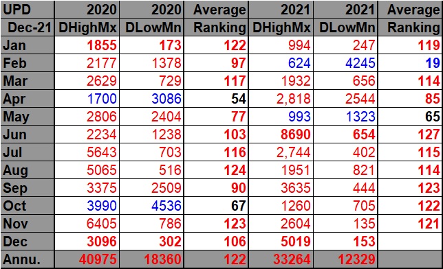
Take a look at my latest record scoreboard for daily high maxes vs. daily low mins updated through 12/21/2021:

DHMX= Daily High Max Reports. DLMN= Daily Low Min Reports. DHMN= Daily High Min Reports. DLMX=Daily Low Max Reports.
For these data sets all monthly ratios of > 10 to 1 DHMX to DLMN or > 10 to 1 DLMN to DHMX are in bold type. The rankings are for the lower 48 states with the warmest ranking since 1895 of average temperatures being 127 and 1 being the coldest as of 2021. Blue colors represent cold months and red warm. Those months and years with counts close to a 1 to 1 ratio of highs to lows are colored black. Boldly colored months, such as June 2021, have ratios of more than 10 to 1 daily record highs to lows or lows to highs, and are either historically hot or cold, most of which have made news.
As shown on our chart, December 2021 is really making news, and we should see one more warm episode east of the Rockies significantly adding to totals on the Record Scoreboard before the year comes to a conclusion.
Adding up every single report we find that the ratio, so far, for the 2020s is:
| 2020s | 74329 | 30,689 | +2.4 to 1 |
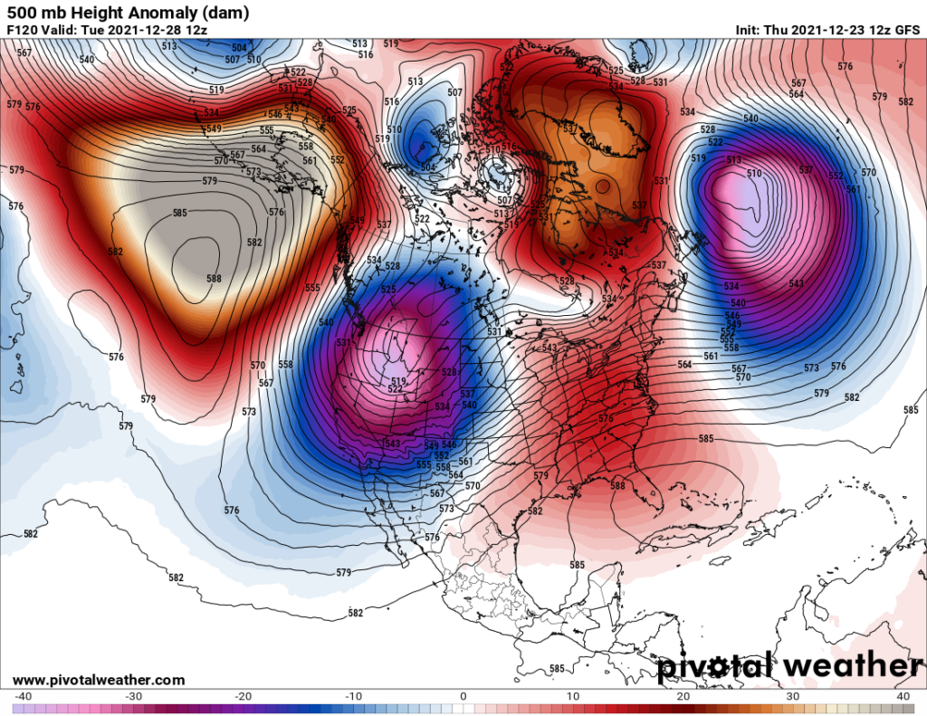
As stated, we are way overdue for a cold spell, and our random meandering global atmospheric jet circulation will deliver, but in a very strange way. Usually across North America, before climate change was a big thing, an extra strong vortex would set up south of Hudson Bay that would deliver record cold Arctic air into the United States during fall and winter. In the coming week going into January a series of vortices will set up over or near the Pacific Northwest, which will lock in record cold air from British Columbia southward through much of the Rockies and West, which would be a highly anomalous weather pattern. Here is just an example that will set up right after Christmas:

On these Pivotal 500 millibar charts anytime you see white colors in association with a vortex, record cold is a good possibility in association with them at the surface. Note all the warm anomalies around the vortex. I contend that this vortex is being squeezed into place due to the influence of an overall climate changed polar vortex.
If we zoom out over the Northern Hemisphere, you can see the many undulations caused by warm anomalies setting up above the Arctic Circle within a weakened, amplified polar vortex:

As shown above, this Arctic warmth is forcing four strong cold anomalies to form fairly far south, including our Pacific Northwest cold lobe.
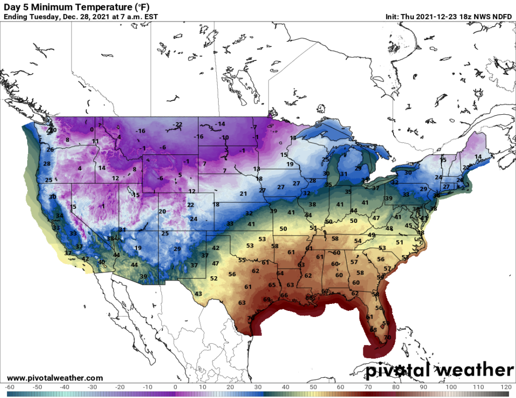
At the surface, here are forecast model minimums for the 28th:

According to Threadex data, 0°F would be a daily record minimum for Seattle, Washington, and by more than ten degrees:
1st place 2nd place 3rd place for Seattle:
| 12/28 | 12 in 1990 | 13 in 1968 | 19 in 1978 |
Seattle won’t be alone. I expect hundreds, if not thousands of reports of record cold, to come into the following NOAA system from the West into early January:
https://www.ncdc.noaa.gov/cdo-web/datatools/records#
As usual, I will be highlighting major reports on this website.
More notes and relevant articles:
Here is more climate and weather news from Thursday:
(As usual, this will be a fluid post in which more information gets added during the day as it crosses my radar, crediting all who have put it on-line. Items will be archived on this site for posterity. In most instances click on the pictures of each tweet to see each article. The most noteworthy items will be listed first.)
Now here are some of today’s articles and notes on the horrid COVID-19 pandemic:
(If you like these posts and my work please contribute via the PayPal widget, which has recently been added to this site. Thanks in advance for any support.)
Guy Walton “The Climate Guy”