The main purpose of this ongoing blog will be to track planetary extreme, or record temperatures related to climate change. Any reports I see of ETs will be listed below the main topic of the day. I’ll refer to extreme or record temperatures as ETs (not extraterrestrials).😉
Main Topic: Stratospheric Cooling Trends and What That Means
Dear Diary. In the last few years both meteorology and climate researchers have shifted a lot of attention to modeling what are termed stratospheric warming events, which portend cold outbreaks from the Arctic region into mid-latitude areas. For those not familiar with the stratosphere, it is the mid layer of the atmosphere above the troposphere. All weather that we are familiar with occurs in the troposphere. There is hard evidence that the stratosphere is cooling overall with time, which is predicted by climate models, but warming events do occur, affecting the troposphere such that Arctic outbreaks of frigid air can still occur in the winter.
In a nutshell and a bit counterintuitively, our climate warms as the stratosphere cools. Read more from NOAA here:
2013 State of the Climate: Stratospheric temperature | NOAA Climate.gov
It makes sense that over time that these stratospheric warming events are becoming less frequent and less apparent such that Arctic outbreaks are less frigidly severe. Forecasting them, though, is a hard nut to crack for meteorologists. All of this has to do with science trying to unravel the secrets in association with the polar vortex.
It appears that there will be another such stratospheric warming event in Canada the next few days. Here are many more details from the Washington Post:
How a disturbed polar vortex could bring winter back to eastern U.S. – The Washington Post
How a predicted polar-vortex disruption could spur winter’s revenge
Forecasters are watching changes in the stratosphere that may trigger a shake-up in the mild weather pattern over the Eastern U.S. and Europe
By Matthew Cappucci and Jason Samenow
February 9, 2023
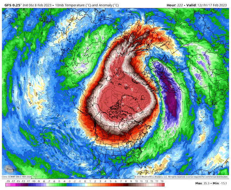
Air temperature anomalies in the lower stratosphere next week as simulated by the American GFS model. (WeatherBell)
Several miles above the North Pole, an atmospheric chain reaction may soon initiate that sets off important changes to weather patterns across the Northern Hemisphere in the coming weeks.
In places where cold and snow have mostly remained absent, the sequence could trigger a wintry revenge. However, it’s still unclear how significant or long-lasting any changes may be and exactly where and when they would occur.
Most of the Eastern U.S. and Europe have escaped winter’s wrath so far, except for some very short-lived Arctic blasts. With signs of spring emerging — from barren ski slopes to budding blooms — it’s natural to wonder whether winter is already over. But there’s some chance this chain reaction could shut down the movement toward spring.
It all begins in the stratosphere, where computer models are coming into agreement that temperatures may leap 60 degrees in the coming week, signaling what’s known as a “sudden stratospheric warming” event.
Although such a spike in temperatures may not sound like something that will bring winter to life, this phenomenon is known for disrupting the polar vortex. When the vortex is knocked off kilter, it sometimes results in significant changes to the prevailing weather patterns over North America, Europe and Asia in the weeks and months that follow.
What a ‘wrecked’ polar vortex meant in 2021
“Often following SSWs [sudden stratospheric warmings], more severe wintry weather becomes more widespread across the Northern Hemisphere,” Judah Cohen, a seasonal weather forecaster with the firm Atmospheric and Environmental Research, wrote in a blog post this week.
Such warming events occur every winter or two, on average, but seldom do they play out the same way. Some result in only mild alterations to the prevailing weather pattern. But others bring about radical change.
Consider 2018. Up until mid-February, it had been a mild winter. But then the stratosphere suddenly warmed, the polar vortex fractured and weather mayhem unfolded over much of Europe and eastern Northern America. In late February, a punishing blast of Siberian air — dubbed the “beast from the east” — invaded Europe, delivering the coldest weather in years. By March, frigid air arrived in eastern North America and triggered four blockbuster storms in the Northeast. The cold didn’t retreat until late April in some areas.
Experts who study the stratosphere and the polar vortex say there’s no reason to expect a repeat of 2018 this year, but they agree that a vortex disruption has a chance to shake up weather patterns.
Inside a disruption of the polar vortex and the chance it happens
There are actually two polar vortexes over the North Pole at any given time — a meandering, wavy one in the troposphere, or lowest level of the atmosphere, and a more concentrated whirlpool of frigid air in the stratosphere above.
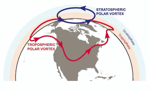
(From Waugh et al., American Meteorological Society, 2017)
The stratospheric polar vortex is a buzzsaw-like maelstrom of cold air, low pressure and spin that gyrates and whirs over the North Pole. The Southern Hemisphere has its own polar vortex over Antarctica.
At present, most major computer models are hinting that a sudden stratospheric warming event could occur next week, which would disturb the vortex.
Simon Lee, an atmospheric scientist at Columbia University, said in an email it “would be the first major sudden stratospheric warming” since Jan. 5, 2021, if it occurs, and the fourth in the past six winters.
A marker of a sudden stratospheric warming event is a reversal in the prevailing polar vortex winds, wrote Amy Butler, an atmospheric scientist with the National Oceanic and Atmospheric Administration, which models are generally simulating.

A simulation of a sudden stratospheric warming event. (WeatherBell)
Even if the winds of the polar vortex don’t fully reverse, models “agree on a strong deceleration” wrote Daniela Domeisen, a professor at the Institute for Atmospheric and Climate Science in Zurich.
Models are generally calling for the sudden stratospheric warming to occur around Feb. 15-17, Lee said. Butler noted that’s within the 10-day time frame in which these events “can be skillfully predicted,” but she cautioned “there is still considerable uncertainty in how things will evolve.”
Lee likened the situation to a “boxing match” between “planetary waves,” or large-scale weather systems nestled within dips and crests of the jet stream and the vortex itself.
“An earlier minor warming,” analogous to a smaller punch from a jet stream disturbance, Lee said, “seems to have left the vortex in a more vulnerable state.” That happened at the end of January.
“There is pretty high certainty that the polar vortex will get strongly disturbed by mid-February, but less certainty that it will be disturbed enough to influence the surface below,” Butler said.
What the polar vortex disruption could mean
Under ordinary circumstances, the stratospheric polar vortex spins like an unperturbed top, minding its business and keeping cold air bottled up high in the Arctic. But if something interrupts the flow of the vortex, it sometimes allows bitterness to slosh down to the mid-latitudes.
But how much cold air is dislodged and where is still up in the air.
“Saying anything about what happens afterward to our weather remains quite challenging,” Lee said. “What we do know for sure is that a sudden stratospheric warming increases the risk of a prolonged negative [North Atlantic Oscillation],” or a weather pattern that favors insurgences of colder air at lower latitudes in Europe and sometimes the Eastern United States.
Sudden stratospheric warmings also often help establish or reinforce “Greenland blocks,” or stagnant domes of high pressure over Greenland. That can result in an atmospheric logjam that maintains prolonged periods of unsettled weather over the U.S. Northeast and East Coast, like what occurred in March 2018.
“Such a configuration can bring colder weather to North America, but it’s actually typically far more noteworthy for bringing cold to northwest Europe,” Lee said.
That said, changes in the lower atmosphere aren’t instantaneous.
“Any direct significant impacts on the weather are typically delayed following the warming by a week or two as the signal propagates into the lower stratosphere, so we’d be looking at early March,” Lee said.
It will probably be at least another week or so before any potential impacts at the mid-latitudes can be ironed out.
“Usually we can make the first more reliable predictions only starting around the time when the sudden stratospheric warming happens,” Domeisen said. “For North America, these predictions are even more difficult than for Europe.”

By Matthew Cappucci. Matthew Cappucci is a meteorologist for Capital Weather Gang. He earned a B.A. in atmospheric sciences from Harvard University in 2019, and has contributed to The Washington Post since he was 18. He is an avid storm chaser and adventurer, and covers all types of weather, climate science, and astronomy. Twitter

By Jason Samenow. Jason Samenow is The Washington Post’s weather editor and Capital Weather Gang’s chief meteorologist. He earned a master’s degree in atmospheric science and spent 10 years as a climate change science analyst for the U.S. government. He holds the Digital Seal of Approval from the National Weather Association. Twitter
Here are some “ET’s” recorded from around the planet the last couple of days, their consequences, and some extreme temperature outlooks, as well as any extreme precipitation reports:
Here is some more new January 2023 climatology:
Here is more climate and weather news from Wednesday:
(As usual, this will be a fluid post in which more information gets added during the day as it crosses my radar, crediting all who have put it on-line. Items will be archived on this site for posterity. In most instances click on the pictures of each tweet to see each article. The most noteworthy items will be listed first.)
If you like these posts and my work please contribute via the PayPal widget, which has recently been added to this site. Thanks in advance for any support.)
Guy Walton… “The Climate Guy”