The main purpose of this ongoing blog will be to track planetary extreme, or record temperatures related to climate change. Any reports I see of ETs will be listed below the main topic of the day. I’ll refer to extreme or record temperatures as ETs (not extraterrestrials).😉
Main Topic: Texas Heatwave British Petroleum Is So Bad, Meteorologists Are Apologizing For It
Dear Diary. I’m now convinced that what I’ve dubbed Heatwave British Petroleum will get much worse next week across Texas and much of the United States and will reattain a historic CAT4 status. Heatwaves that attain my CAT4 and CAT5 status are killers and eventually get blamed for hundreds if not thousands of deaths, unfortunately, and will be one more common as the world continues to get hotter from carbon pollution.
Heatwave British Petroleum has gotten so bad that National Weather Service meteorologists are embarrassingly apologizing for it. Check out this recent summary from the Washington Post:
The punishing Texas heat wave could expand and get worse – The Washington Post0
Texas heat wave is so bad, meteorologists are apologizing for it
Dangerous heat expected to continue for at least another week and possibly longer

By Dan Stillman
June 23, 2023 at 1:39 p.m. EDT
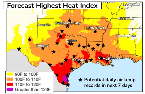
Heat index forecast through June 28. (National Weather Service)
A brutal Texas heat wave is now entering its third week for some places and shows no signs of slowing down. If anything, it could expand north and east and get worse over the next week. The expected intensity and longevity of the heat has forecasters concerned about dangerous and deadly consequences and even apologizing for it.
“Sadly, temps are going to creep back upward next week, too. Sorry, y’all. We’re gonna get back to our typical levels of heat someday, but not real soon. Keep up the fight against the heat!” the National Weather Service in Houston tweeted Friday morning.
The heat was ramping higher once again Friday after easing by only a few degrees Thursday. Six out of the 10 hottest U.S. cities Friday were expected to be in Texas, according to The Washington Post’s U.S. heat tracker, with each city’s temperature forecast to top 100 degrees every day through Thursday. Meanwhile, the heat index is predicted to reach 110 to 120 degrees or higher for an extended period across a large swath of the state. Numerous records could be threatened.
“Oppressive and persistent heat will become increasingly dangerous and potentially deadly in south and south-central Texas, especially to people repeatedly exposed for long durations. Many locations in those parts of Texas have already experienced a yearly record number of hours of dangerously high heat index readings,” the National Weather Service said in a summary of key messages about the heat wave. “There is increasing confidence that the dangerous heat wave will continue through the beginning of the July Fourth holiday week.”
Computer models project that the heat will be most expansive next Wednesday and Thursday when it could creep north into Oklahoma, Kansas and Missouri and also eastward into Arkansas and Louisiana.
Many records already broken
The coming six days of punishing heat follow numerous records that were tied or broken during the past week. San Angelo reached an all-time record high of 114 on Tuesday and then tied that record again Wednesday.
“As much as we don’t want to tweet this … We did hit 114° here at the office in San Angelo today. So that means we have tied our all-time record high, set approximately 24 hours ago,” the Weather Service office in San Angelo said.
Del Rio reached an all-time record high of 115 on Wednesday, breaking the previous record of 113 set Tuesday. June 16 to 22 was Del Rio’s hottest seven-day period on record, weather enthusiast Don Sutherland tweeted. Temperatures on Thursday topped out a few degrees lower at 108 and were forecast to be about the same Friday before trending hotter again.
Some of the other all-time record high temperatures set during the month of June include 118 at Rio Grande Village, 117 at Falcon Lake, 116 at Cotulla, 115 near Laredo and at Cope Ranch, 113 at Carrizo Springs, and 112 at Comanche and Bronte, according to data compiled by Sutherland.
Many locations are piling up the number of hours spent in triple-digit territory. Between June 17 and 21, portions of south and southwest Texas spent 30 to 40 hours, out of a possible total of 84 hours, at or above 100 degrees, tweeted Greg Carbin, chief of the Forecast Operations Branch at the National Weather Service’s Weather Prediction Center. Carbin also posted maps showing a 24-hour average temperature of 100 degrees between the Rio Grande and San Antonio.
The humidity has driven the heat index past 110 degrees across most of the state. In Corpus Christi, where the heat index reached 125 degrees Saturday, “13 days have reported the highest heat index for that day going back to 1947,” the Weather Service said.
The heat index reached at least 116 degrees in McAllen for the 10th consecutive day Thursday. “This streak shatters others we found in June, as well as total June days with such occurrences (4 in 2019 and 1998). On all days in the streak, 116+ lasted 1 to 5 hours,” the Weather Service in Brownsville reported.
High temperatures were a few degrees cooler across parts of the state Thursday after severe thunderstorms and a violent tornado struck some areas Wednesday. Crews in Southeast Texas, including around Houston, were rushing to restore power before temperatures climbed again. More than 400,000 customers were without power at one point late Wednesday, but that number had dropped to less than 59,000 as of Friday morning.
Unrelenting heat dome, climate change fueling high temperatures
A historically intense heat dome, or sprawling area of high pressure centered over northern Mexico that traps heat underneath it, was to blame for the ongoing heat wave. Scientists have found that such heat domes are becoming larger and more intense with human-caused climate change.
Computer models project the strength of the heat dome over northern Mexico, swelling into Texas, to hover in the 99th-percentile range into next week — meaning it’s statistically exceptionally rare.
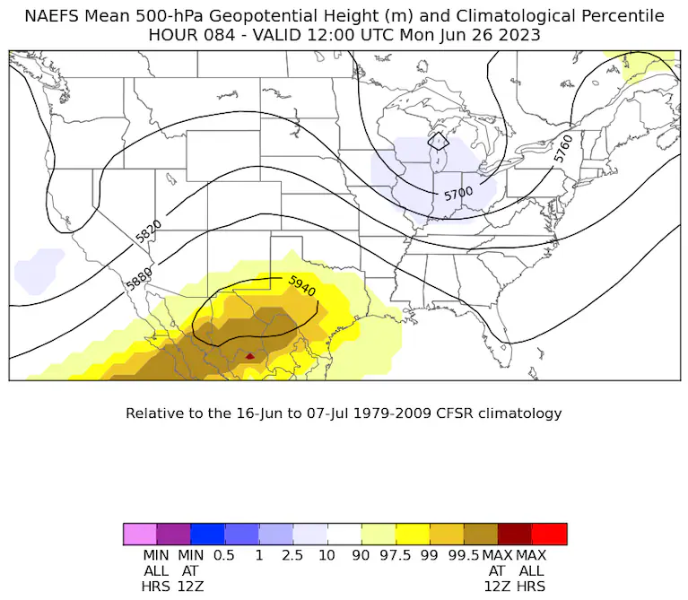
Computer models project strength of heat dome over northern Mexico on Monday to rank around the 99th-percentile for strength. (NOAA)
Climate Central, a nonprofit science communication organization based in Princeton, N.J., has developed the Climate Shift Index, which estimates how much climate change is increasing the likelihood of extreme heat. The index is at a Level 5 over southern portions of Texas, indicating that climate change made this excessive heat at least five times more probable.
The heat dome responsible for the current heat wave is expected to persist through at least next week and possibly into the following week. That means an extended stretch of daytime highs in the 100s across much of the state while the heat index could top 120 degrees in South Texas.
As is the case with most heat waves, it is the warm nighttime temperatures that make it especially dangerous.
“There may be more danger than a typical heat event, due to the longevity of near-record or record high nighttime lows and elevated heat index readings,” the Weather Service said. “It is essential to have a way to cool down and interrupt your heat exposure.”
The heat dome should finally start to weaken by the end of next week or the following week.
“We will escalate the heat daily until about Wednesday or Thursday, when things should peak. This will push us into the low-100s for highs, with lows again near 80,” wrote Houston-area meteorologist Matt Lanza. “Should that happen, perhaps we can resume more typical summer weather here in Houston, which while still certainly hot, would be a little less stressful on our bodies.”
By Dan Stillman Dan Stillman is a meteorologist and editor for the Capital Weather Gang. He earned an M.S. in Meteorology from Texas A&M University, and a B.S. in Atmospheric, Oceanic and Space Sciences from the University of Michigan. Twitter
Much More:
Here are some “ET’s” recorded from around the planet the last couple of days, their consequences, and some extreme temperature outlooks, as well as any extreme precipitation reports:
Here is more climate and weather news from Saturday:
(As usual, this will be a fluid post in which more information gets added during the day as it crosses my radar, crediting all who have put it on-line. Items will be archived on this site for posterity. In most instances click on the pictures of each tweet to see each article. The most noteworthy items will be listed first.)