The main purpose of this ongoing blog will be to track planetary extreme, or record temperatures related to climate change. Any reports I see of ETs will be listed below the main topic of the day. I’ll refer to extreme or record temperatures as ETs (not extraterrestrials).😉
Main Topic: Remarkable Warmth at the Winter Solstice
Dear Diary. As winter begins across the Northern Hemisphere, I don’t recall seeing as much anomalous warmth occurring across this half of the planet as we are seeing now:
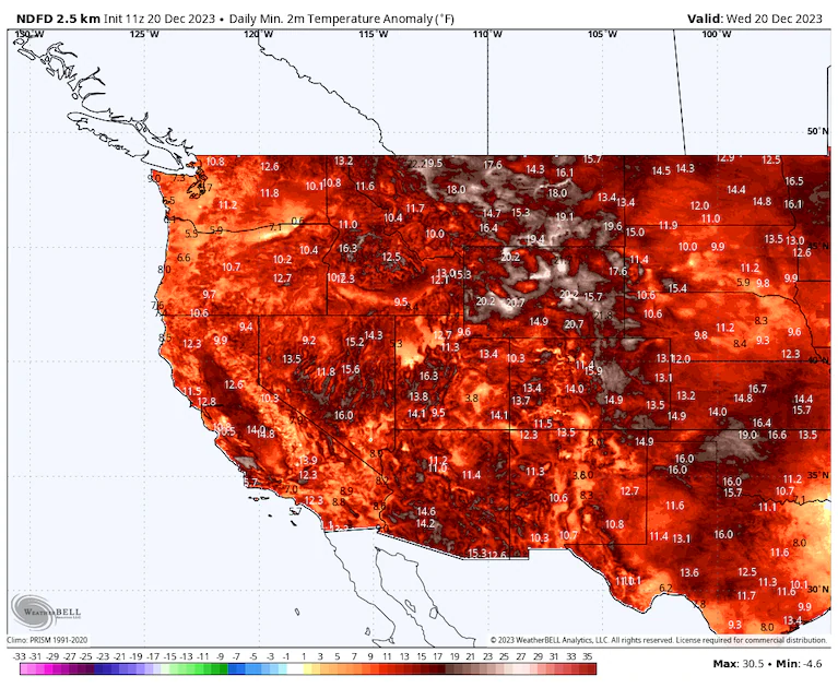
Extreme 20°C Anomalies all over the northern hemisphere. Clouds have shown more sensitivity to heat and aerosols than previously hoped, so we will see more and more warming from Cloud scattering. https://t.co/tnhFa5BaNc pic.twitter.com/3yw2a9OC5A
— Thomas Reis (@peakaustria) December 20, 2023
Exceptionally mild temperatures are expected in the following days in most of mid latitudes of the Northern Hemisphere from North America to Europe to Central Asia (and after the 24th also in East Asia).
— Extreme Temperatures Around The World (@extremetemps) December 21, 2023
Dozens millions people will live their warmest Christmas day in their lives. pic.twitter.com/3MYkLnOl3q
Something exceptional and potentially historic looks to take place middle of next week in Canada, with air mass up to 28C above average. If this warmth aloft imprints on surface many records will fall. pic.twitter.com/J92Yg2v0ix
— London & Southeast 🔆 (@TheSnowDreamer) December 20, 2023
Closer to home across the lower 48 states, record warmth will be experienced by many, particularly across the Midwest. Bah Humbug! Both Santa and old Scrooge will be upset because this year may have the least amount of traditional holiday snow on record at Christmas. Yes, I’m dreaming of a white Christman, just like the ones I used to know, but climate change is putting any dreams of that more and more in the past.
Snow cover is record low across North America and especially the US. Lots of dreaming of White Christmases but not many living it. Thread 1/ pic.twitter.com/j9AlgZ5KQh
— Jeff Berardelli (@WeatherProf) December 22, 2023
On this diary post I’m presenting not one but two articles for today’s main subject. A new Washington Post article details record warmth that will be occurring this week. The second from Climate Central ties this warmth with anthropogenic climate change:
Instead of a white Christmas, record warmth to blanket Midwest – The Washington Post
Instead of a white Christmas, record warmth to blanket Midwest
Santa Claus may want iced tea instead of hot chocolate this year

December 21, 2023 at 6:00 a.m. EST

Low temperatures are predicted to be 20 to 40 degrees above normal Christmas Eve morning from Texas to Minnesota. (weatherbell.com)
Santa Claus may want iced tea instead of hot chocolate this Christmas while passing over the central United States. Unusually mild weather is expanding across the Lower 48 and is expected to break dozens of records as a warm Pacific weather pattern — connected to a strong El Niño event and boosted by human-caused climate change — sweeps over North America.
Many locations used to a white Christmas in the Upper Midwest and western Great Lakes will have bare ground and bask in temperatures about 30 degrees above the norm.
“We’re in uncharted weather and climate territory again in Minnesota this December,” wrote Paul Huttner, a meteorologist for Minnesota Public Radio. “This will likely be the first time on record that much of northern Minnesota has not seen a white Christmas.”
Minneapolis may set record highs on both Christmas Eve and Christmas Day as atypical warmth stretches from Texas to north of the Canadian border. Some spots could surpass calendar day record highs by 5 to 10 degrees.
Traveling for Christmas? We’ve got your city-by-city holiday forecast
Numerous record highs are set to fall daily as the warmth expands northward and eastward. Some have already been set in the Southwest United States.
Warm air to spill east into the holiday weekend
The warmth is set to spread north and east in large part because of a strong Pacific jet stream drawing mild, moisture-laden air into Canada and the northern United States. A strong, slow-moving storm system drenching southern California is also helping to pull in mild air.
On Wednesday, much of the western United States saw morning lows of 10 or more degrees above average — the beginning of a span of record-challenging warmth.
Phoenix was among southwestern cities that posted record warm morning lows. Its low of 60 degrees topped 57 degrees on the same date in 1921 and was 16 degrees above average. Both Los Angeles International Airport and its downtown weather station matched record warm lows for the date of 59 and 61 degrees, respectively.
Thursday, low temperatures at least 20 degrees above average will set records from the southern Plains into the Midwest. A smattering of additional records are a good bet Friday and Saturday in the same region as warm, moist air is pumped northward.
The most exceptional warmth is anticipated over the holiday weekend when morning lows may approach 40 degrees above normal in the Upper Midwest. Afternoon high temperatures should rise 20 to 30 degrees above normal.
Unusually mild weather will spread from Minnesota, Iowa and eastern South Dakota on Saturday toward the western half of the Great Lakes on Christmas Day. Many locations that normally post highs in the 20s and 30s at this time of year will instead be in the 40s and 50s.

Places that are forecast to see record or near record highs. (Weather Prediction Center)
Cities that could set record highs on Christmas Eve
A white Christmas is virtually out of the question in many places that are accustomed to it because of temperatures that will be way too warm. Below are some locations projected to see record highs on Christmas Eve:
- International Falls, Minn. — Forecast is 42 or about 22 degrees above normal (record is 42 in 1994).
- Minneapolis — Forecast is 53 or about 27 degrees above normal (record is 46 in 1957).
- Rockford, Ill. — Forecast is 54 or about 22 degrees above normal (record is 55 in 2021).
- Sioux Falls, S.D. — Forecast is 53 or about 24 degrees above normal (record is 50 in 2021).
Keep in mind that International Falls ordinarily has a 93 percent chance of a white Christmas and Minneapolis a 74 percent chance.

Predicted high temperature differences from normal on Christmas Eve. (weatherbell.com)
A record warm Christmas morning for many
Dozens of locations in the Upper Midwest could register their warmest Christmas mornings on record. Here are a few examples:
- Chicago — Forecast is 48 or about 25 degrees above normal (record is 46 in 1936).
- Duluth, Minn. — Forecast is 37 or about 30 degrees above normal (record is 34 in 1877).
- Eau Claire, Wis. — Forecast is 44 or about 34 degrees above normal (record is 35 in 1936).
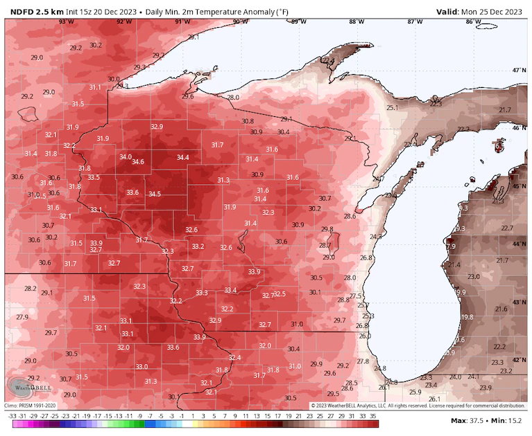
Predicted low temperature differences from normal on Christmas morning. (weatherbell.com)
While this bout of extreme warmth is tied to the prevailing jet stream and amplified by the El Niño climate pattern, a trend toward less extreme cold in winter has a strong connection to human-caused climate change.
Historically low snow cover extent
A lack of snow is both contributing to the dearth of cold in the Lower 48 states and also an indicator of it. The Dec. 21 snow cover extent is the lowest percentage in records dating to 2003. Snow covered the ground over only 14.3 percent of the country.

There’s little indication that the snow cover will meaningfully expand in the coming days.
The snow is not only depleted in the contiguous United States but also in Canada, where it has also been historically warm.
Environment Canada announced Tuesday that numerous locations in Newfoundland and Labrador reached record highs for December as a mild East Coast storm pumped warm, moist air northward.
The snow cover over North America is also the lowest on record for the time of year and more typical of early April.
The weather pattern may shift to a more wintry one in January, although models project that Canada and the northern tier of the United States will remain somewhat milder than normal.
Jason Samenow contributed to this report.
By Ian Livingston Ian Livingston is a forecaster/photographer and information lead for the Capital Weather Gang. By day, Ian is a defense and national security researcher at a D.C. think tank. Twitter
Analysis: Winter warmth in the U.S. Midwest in the days before Christmas 2023 linked to climate change
December 20, 2023
For the U.S. Midwest states, chances for a White Christmas are looking slim. Climate Central analysis shows that the unusually warm wintertime temperatures forecast over the five days leading up to and including Christmas Day (December 21-25) for much of the Upper Midwest are at least twice as likely due to human-caused climate change.
According to the National Weather Service, a White Christmas is defined as at least 1 inch of snow on the ground at 7 am local time on Christmas Day. The historic probability of a White Christmas in this part of the country runs from 40% to 90+%. See the probability for your location, with ready-to-use graphics.

What sort of unusual temperatures are forecast?
- Daily average temperatures are expected to be 20-35°F above average (based on 1991-2020 climate normals) in some regions during this five-day period – including large parts of Minnesota, Wisconsin, and Iowa.
- Daily temperatures across the Upper Midwest states are generally not expected to dip below 32°F, even at night, for most of the five days leading up to Christmas Day. With forecast temperatures above 32°F, existing snow depth is likely to melt, and conditions are not supportive of falling snow.
- Temperatures are not expected to dip below 32°F on any day between December 21 and 25 across all of Illinois, much of Iowa, and parts of Minnesota, Wisconsin and Michigan.
What impact is climate change having?
- During this five-day period leading up to and including Christmas Day, the unusually warm conditions have a strong climate change influence. Most days across the affected states are expected to reach a Climate Shift Index (CSI) level of at least 2, meaning that temperatures in those areas are at least two times more likely because of human-caused climate change.
- In large parts of Minnesota, Wisconsin and Iowa, all five days in this period are expected to reach a CSI level of at least 2, while surrounding areas are expected to experience four days at or above CSI level 2.
- Most of Michigan’s lower peninsula is expected to experience three days of at least CSI 2, while in the upper peninsula, four days are expected to reach at least a 2 on the CSI scale.
- Some days are expected to reach a CSI level 5 in parts of Minnesota, Wisconsin, Michigan, and surrounding areas. A CSI of 5 indicates an exceptional climate event, where conditions were made at least five times more likely due to climate change.
Use the Climate Shift Index global map to see CSI levels in your city and region.
How do we know climate change is having an impact?
The Climate Shift Index uses peer-reviewed methodology to estimate how climate change has increased the likelihood of a particular daily temperature. It can be run using historical or forecast temperatures.
Using computer models, we compared the likelihood that these temperatures would occur in a world without carbon emissions released by humans, versus in today’s world with decades of carbon emissions building up in the atmosphere. This is an established scientific method to determine how much climate change has or has not affected individual extreme weather events.
For this analysis, temperatures come from the National Center for Environmental Prediction’s Global Forecast System.
What do experts have to say?
Dr. Andrew Pershing, VP of Science at Climate Central, said:
“People dreaming of a White Christmas will be sorely disappointed this year. As long as people keep burning coal, oil, and natural gas, events like the string of unusually warm temperatures in the Midwest will become more and more common.”
To request an interview with a Climate Central scientist, please contact Peter Girard at pgirard@climatecentral.org
More:
Incredibly mild conditions during the next few days sets up a rare bare ground Christmas for Int'l Falls, Minn., Minneapolis, and much of Central/Midwest US to the East. https://t.co/SMPeJMsdqh
— Andrew Freedman (@afreedma) December 21, 2023
Here are more “ET’s” recorded from around the planet the last couple of days, their consequences, and some extreme temperature outlooks, as well as any extreme precipitation reports:
SOUTH AMERICA Heat Wave:
— Extreme Temperatures Around The World (@extremetemps) December 20, 2023
More records yesterday in BOLIVIA:
The Amazon town of Cobija with 37.3C had its hottest December day on record.
Cobija had already broken the records of all previous months (including its all time high) and did it several times each month:Exceptional. https://t.co/8jh9Hr8VsK
Another record in ARGENTINA, this time in the Southern province of Tierra del Fuego.
— Extreme Temperatures Around The World (@extremetemps) December 21, 2023
Rio Grande rose to 25.0C which is a new monthly record. https://t.co/9RyUAaldiK
#Australia Heat Wave turns extreme:
— Extreme Temperatures Around The World (@extremetemps) December 21, 2023
47.6C today at Marble Bar,Western Australia, the new highest temperature so far in the Southern Hemisphere this season.
Australia finally took the lead, overtaking South Africa.
Next days similar temperatures are expected in Marble Bar. pic.twitter.com/ar0h9wJTYm
ASIAN COLD SPELL
— Extreme Temperatures Around The World (@extremetemps) December 21, 2023
More records today in #China:
-31.3 Qingshuihe all time low
-23.4 Rongcheng all time low
-29.1 Hohhot monthly record low
NORTH KOREA
Exceptional cold with -38.9C at Samjiyon (1,382 m asl),new monthly record and coldest December day in North Korea since 1976. https://t.co/FzjGN0vlb0
The cold air from the North is entering VIETNAM while record hot conditions persist in the South.
— Extreme Temperatures Around The World (@extremetemps) December 20, 2023
The result was a huge and unusual difference on 19 December with a min. temperature of 1.1C at Mau Son in the North and a record 36.0C at Tay Ninh in the South. https://t.co/PVN9guGzMZ
Another heat wave in SOUTH AFRICA with temperatures rising above 45C at 600m asl at Augrabies Falls..
— Extreme Temperatures Around The World (@extremetemps) December 21, 2023
December records were broken today:
41.7C Kathu 1186m asl
41.6 Kimberley 1196m
More records are expected in the next couple of days. pic.twitter.com/gN2aGTptbm
More record heat in INDONESIA.
— Extreme Temperatures Around The World (@extremetemps) December 21, 2023
Yesterday Kaimana in West Papua had its hottest December day on record with 36.7C and its second hottest night for any month with a Tmin of 28.0C.
Another fact:Kaimana hasn't recorded any single colder than average month since September 2019. pic.twitter.com/OhNr7MaYRj
Historic in DENMARK:
— Extreme Temperatures Around The World (@extremetemps) December 21, 2023
It 's now a fact that 2023 is the wettest calendar year recorded in Denmark since 1874.
As of 20th December morning, 906.6 mm has fallen since 1st January and more rain is on the way.
That despite a long dry spell in early summer with no rain for 22 days. https://t.co/TeiTvYOrVX
Here is More November 2023 Climatology:
Global mean sea surface temperature anomalies (departure from average) so far this year ➡️ easily the warmest on record
— Zack Labe (@ZLabe) December 21, 2023
[Data from @NOAA ERSSTv5 averaged over January to November] pic.twitter.com/AbwRHh7Izv
Another global sea level update with satellite altimetry data now processed by @CNES (AVISO) through early November 2023 🌊
— Zack Labe (@ZLabe) December 22, 2023
+ Note that this graph was produced by https://t.co/VyYfR0u0mx pic.twitter.com/3CIfiBgdwO
The September to November season was a scorcher, with the three largest global temperature anomalies on record.
— Dr. Robert Rohde (@RARohde) December 21, 2023
19% of the Earth's surface – including 32% of the land – saw a three month average that set a new local record high.https://t.co/C4EW8sRxDC pic.twitter.com/KTVjFfCUMr
According to Berkeley Earth:
— Prof. Eliot Jacobson (@EliotJacobson) December 22, 2023
"2023 is virtually certain (99% chance) to average more than 1.5 °C above our 1850-1900 baseline."https://t.co/qrk5EBtgYk pic.twitter.com/u9AAxa0Ni2
Berkeley Earth November Temperature Update
— Berkeley Earth (@BerkeleyEarth) December 21, 2023
The warmest November since measurements began in 1850, with records for both land and ocean individually.
Essentially certain that 2023 becomes the warmest year, and very likely to exceed 1.5 °C in our dataset.https://t.co/GLdHSIHTmY pic.twitter.com/0XaqL0SCc4
Here is More Climate and News from Thursday:
(As usual, this will be a fluid post in which more information gets added during the day as it crosses my radar, crediting all who have put it on-line. Items will be archived on this site for posterity. In most instances click on the pictures of each tweet to see each article. The most noteworthy items will be listed first.)
Looking for a last-minute gift? Books are a great idea! I have a list^ of my top climate recommendations here. There's something for everyone on your list, from your niece* who's (rightly) worried to death about it, to yes, even Uncle Jim.** Check it out! https://t.co/K3cKA26BGU pic.twitter.com/L6xOLg5qPp
— The Real Prof. Katharine Hayhoe (@KHayhoe) December 21, 2023
The #ArcticReport Card from @NOAA shows impact of #climatechange on ecosystems and communities.
— World Meteorological Organization (@WMO) December 21, 2023
The Arctic is heating at least twice as fast as any other part of the world because reduced snow and ice reflect less incoming sunlight. https://t.co/YHdYh1lxfp pic.twitter.com/sWsag1Mygr
If you're not sure how a carbon budget works (and you should be! It's critical for your future) then watch these 2 minutes… https://t.co/stUmk7LuTj
— Prof. Stefan Rahmstorf 🌏 🦣 (@rahmstorf) December 21, 2023
For those keeping score, the latest ERA5 data point for Global surface temperatures (December 15th) was 1.62°C above the 1850-1900 IPCC baseline, and our "climate challenged" little planet is once again in record territory for the day. pic.twitter.com/9qpPN5Rmkw
— Prof. Eliot Jacobson (@EliotJacobson) December 21, 2023
Have I shown this recently?
— Prof. Eliot Jacobson (@EliotJacobson) December 21, 2023
291 days of record high sea surface temperatures and counting … pic.twitter.com/Lx9gq8FzJ6
Jeff Berardelli on Climate Tipping Points https://t.co/wS3tA2ZCWR
— Peter Sinclair (@PeterWSinclair) December 21, 2023
From our archives: From our archives: “Humanity is running an ecological Ponzi scheme in which society robs nature and future generations to pay for boosting incomes in the short term,” a group of ecologists writes.https://t.co/rrG16oybQm
— Yale Environment 360 (@YaleE360) December 21, 2023
Your 'moment of doom' for Dec. 21, 2023 ~ I think that I shall never see…
— Prof. Eliot Jacobson (@EliotJacobson) December 21, 2023
"On average, the area of forest burnt by fires between 2001 and 2022 was 11 times the size of the forests planted by humans during that period."https://t.co/LJmX3xm9Bp
"Please make no mistake. Climate change is the biggest threat to global security that modern humans have ever faced." Sir David Attenborough.
— Mike Hudema (@MikeHudema) December 21, 2023
No time to wait. #ActOnClimate #climate #energy #stopfossilfuels #go100re pic.twitter.com/0wZGbZGglV
State of the climate 2023
— Assaad Razzouk (@AssaadRazzouk) December 21, 2023
>Warmest year on record
>2°C breached for first time
>June, July, August, September, October and November warmest respective months on record
>Antarctic sea ice record low maximum extent
>Ocean temperatures hottest on record
Because: oil, gas & coal pic.twitter.com/SjLbUFIFbj
Today’s News on Sustainable Energy, Traditional Polluting Energy from Fossil Fuel, and the Green Revolution:
"Amid a year of record-breaking climate disaster, the U.S. broke its record on oil production" by @MatthewRozsa for @Salon https://t.co/HEFFpIUTFA
— Prof Michael E. Mann (@MichaelEMann) December 21, 2023
1 m² of solar panels now give you 38% more power for 83% less money than eleven years ago! https://t.co/GLnB7eTPqB
— Kees van der Leun (@Sustainable2050) December 21, 2023
Good morning with good news: Renewables are having a record year for new capacity additions in 2023 and remain on course to be world's leading source of electricity by 2025!
— John Raymond Hanger (@johnrhanger) December 21, 2023
RE will be more than coal.
RE could be more than coal & gas combined by 2030!https://t.co/Ef4NfzZDHM pic.twitter.com/5UQHhl2S9Y
new investigation: dozens of utilities offer homebuilders incentives –including cash and luxury travel – to install gas appliances
— 𝕯𝖍𝖆𝖗𝖓𝖆 𝕹𝖔𝖔𝖗 (@dharnanoor) December 21, 2023
trade groups are also training members to sell builders on the continued use of gas, newly revealed recordings show
🧵 https://t.co/bXbCElA8hY
#ThursdayMorning Reading: "They are scared about building electrification, and they are lobbying aggressively" The tale of two Colorado towns and the ongoing fight for #electrification. https://t.co/4iSCQPEeUf
— Silicon Valley North (@CCLSVN) December 21, 2023
Wind turbines generate more than half of UK’s electricity amid Storm Pia https://t.co/ooyTOfoyGM
— Guardian Environment (@guardianeco) December 21, 2023
'Ørsted to press ahead with world’s largest offshore wind farm in North Sea. Hornsea 3 project off the Yorkshire coast will be able to supply power for 3.3mn homes.'https://t.co/fwzXp8ipwa
— Dr Paul Dorfman (@dorfman_p) December 21, 2023
Hornsea 3 (2.9 GW) Set To Become World’s Largest Offshore Wind Farm https://t.co/LUJbl1wqnV @Orsted
— Mark Z. Jacobson (@mzjacobson) December 21, 2023
More from the Weather Department:
Happy Winter! Today marks the Winter Solstice, when the Earth's northern hemisphere is tilted furthest away from the Sun in its yearly orbit around it. This also means that today is the shortest of the year for those of us north of the equator. pic.twitter.com/HQgqqlR0Xn
— National Weather Service (@NWS) December 21, 2023
Happy #WinterSolstice! 🌎🌄❄️
— NOAA Satellites (@NOAASatellites) December 21, 2023
Astronomical winter officially starts at 10:27 pm EST, marking the longest night in the Northern Hemisphere. Enjoy a year-long visual journey with daily images from @NOAA's #GOESEast 🛰️, showing the changing seasons due to Earth's 23.5° tilt. pic.twitter.com/EWsUEnrxOr
Maine still has 135k without power this Thursday AM from last weekend's powerful storm. Current morning temps here. BRRRRRRR! https://t.co/Hk3pbO7x8H pic.twitter.com/dPsCJ4avE7
— Mike's Weather Page (@tropicalupdate) December 21, 2023
Wow. AR5. That certainly matches with the impressive winter rainfall totals and near record flooding in spots. https://t.co/3i7eqSmEV9
— Jeff Berardelli (@WeatherProf) December 20, 2023
Live, pop-up YouTube session begins in 5 minutes to discuss ongoing extreme rainfall and worsening flash flood situation across portions of central and southern CA coast. Expect a radar/satellite tour. #CAwx #CAwater https://t.co/n4wfbFr0VT
— Dr. Daniel Swain (@Weather_West) December 21, 2023
More than 20 million people are under flood advisories in California.
— The Weather Channel (@weatherchannel) December 21, 2023
This is the highest risk since the remnants of Hurricane Hilary impacted the region in August. pic.twitter.com/cHt3Tcg2Lc
Santa will need a raincoat along the upper Gulf northward Christmas Eve. Some heavy rains possible. https://t.co/Hk3pbO84Yf pic.twitter.com/LE21828bJF
— Mike's Weather Page (@tropicalupdate) December 21, 2023
Wicked fast jet streams across the planet right now!! Various reasons, from the influence of El Niño to substantial blocking patterns squeezing jets, and excess energy in the background from climate change interacting with the prevailing pattern, etc… pic.twitter.com/5MSatdDMat
— Jeff Berardelli (@WeatherProf) December 22, 2023
Once we get CA system (blue) in and across USA past Christmas it does appear we will open up a path to get more CA storms in to begin Jan 2024. This is not a super cold pattern at this point. pic.twitter.com/t6gtBWSvtt
— Jim Cantore (@JimCantore) December 21, 2023
Powerful jet stream roaring across the Atlantic right now. A perfect configuration for high winds in Europe. Wind power is delivering at record levels in Germany.
— Scott Duncan (@ScottDuncanWX) December 21, 2023
You can see Storm Pia form on the other side of the Atlantic and boost over to Europe. Flights from North America to… pic.twitter.com/W7LryMbVPJ
Rough weather for Denmark and NW-Europe as #StormPia rapidly intensifies in the left exit region of the strong jet stream.
— Mika Rantanen (@mikarantane) December 21, 2023
Quite a strong pressure gradient between the storm and the Azores High (88 hPa!). pic.twitter.com/n96sLMhPMo
More on the Environment and Nature:
The insects are almost gone – soon the birds will be gone too and Flowers are ‘giving up’ on scarce insects and evolving to self-pollinate, say scientists https://t.co/ScnMpPXx6i
— GO GREEN (@ECOWARRIORSS) December 21, 2023
'ABSOLUTE HORROR': DEVON VILLAGE IN SHOCK AT FELLING OF 100 ANCIENT BEECH TREES
— Bill McGuire (@ProfBillMcGuire) December 21, 2023
If it were up to me I would jail the bastards that facilitated this, and throw away the key.
Inexcusable and unacceptable.https://t.co/e016zFFbVS
Stratospheric clouds contribute to ozone depletion. The #CopernicusAtmosphere data show a significant thinning of the ozone layer in the area.
— Copernicus ECMWF (@CopernicusECMWF) December 21, 2023
See the forecast 👉https://t.co/Jz7TE7csxZ https://t.co/njDtidgJjv pic.twitter.com/9OgpwfzjRk
Thanks to Tribes’ stewardship & Earthjustice’s legal defense, northern Montana's bison population has grown from 34 to more than 200. The animals are beginning to revive the landscape and offering an antidote to habitat loss, one of the main drivers of the biodiversity crisis pic.twitter.com/NcKOZibylg
— Earthjustice (@Earthjustice) December 21, 2023
Is human supremacy the problem?https://t.co/pErHRnGohH pic.twitter.com/EoSmrHnll4
— Dr. William J. Ripple (@WilliamJRipple) December 21, 2023
More on Other Science and the Beauty of Earth and this Universe:
Happy #DecemberSolstice! 🌞
— Zack Labe (@ZLabe) December 21, 2023
Understanding seasons – a look at the hourly incoming solar radiation during the two solstices (23.5°N/S). I've added a red marker for ease of viewing. Dashed line shows the equator
This graphic can now be found at https://t.co/Gq4vXKSUnO pic.twitter.com/rLka5gw7lU
Even the night sky is spreading some holiday cheer with what could be the largest Christmas tree in the universe! 🎄
— AccuWeather (@accuweather) December 21, 2023
On Tuesday, NASA released an image of NGC 2264, also known as the “Christmas Tree Cluster.” https://t.co/1BN28Nd5kY pic.twitter.com/9LjrQiprRD
We need greener cities with parks and more trees in backyards and nearby forests.
— Green is a mission (@Greenisamissio1) December 21, 2023
"Studies suggest that accessible natural regions are a serious resource for improving mental health in our rapidly urbanizing world," writes Hiroko Ochiai of the NHO of Japan.💚🌱☘️🌿🌳🌲🍀💚 pic.twitter.com/WqsL0oKWTr