The main purpose of this ongoing blog will be to track planetary extreme, or record temperatures related to climate change. Any reports I see of ETs will be listed below the main topic of the day. I’ll refer to extreme or record temperatures as ETs (not extraterrestrials).😉
Main Topic: Texas is Toast from Heatwave Hess This Week
Dear Diary. Before we move onto other topics or other areas of the planet suffering from excess heat, let’s concentrate again on Heatwave Hess in Texas and the southern Plains.
Today Hess has been paired down to Texas but still is a major CAT 3 so dangerous by my book:
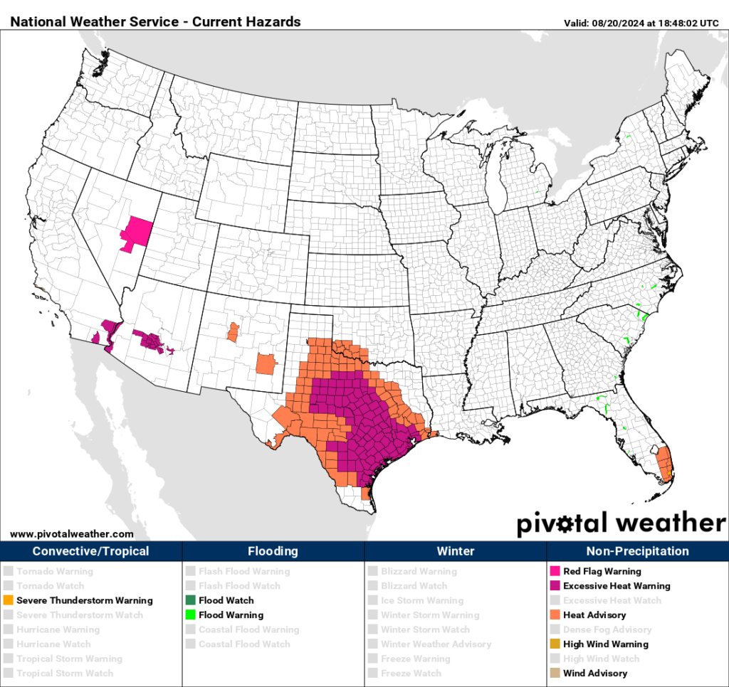
As posted this week, the is heat should move back towards the north and east by late this week:
Ian Livingston has written a nice article on Hess’s heat in Texas, with some record reports coming from that state, which I’m reposting for your perusal today:
Where heat is worst in the southern and central U.S. this week – The Washington Post
Where heat is worst in the southern and central U.S. this week
Temperatures will reach 100 to 110 in much of Texas over the next several days.

A person crosses a street in the afternoon heat May 25 in Houston. (Jon Shapley/Houston Chronicle/AP)

August 20, 2024 at 11:31 a.m. EDT
A powerful and slow-moving heat dome stretching from the Desert Southwest to Texas has fueled punishing conditions for the region since late last week. And the heat seems poised to stay put, with record temperatures likely through the rest of this week.
In Texas, Houston, Austin, San Antonio, Corpus Christi and Waco are all under heat warnings Tuesday. Much of the rest of the state is under a heat advisory.
“Afternoon highs up to 110 degrees and heat index values up to 113 degrees will significantly increase the potential for heat related illnesses,” warned the Weather Service office serving the Dallas-Fort Worth region.
Cities in New Mexico, including Albuquerque and Roswell, are also under heat alerts Tuesday, where highs will range from 100 to 105. Further west, Phoenix is under a heat warning for highs past 110.
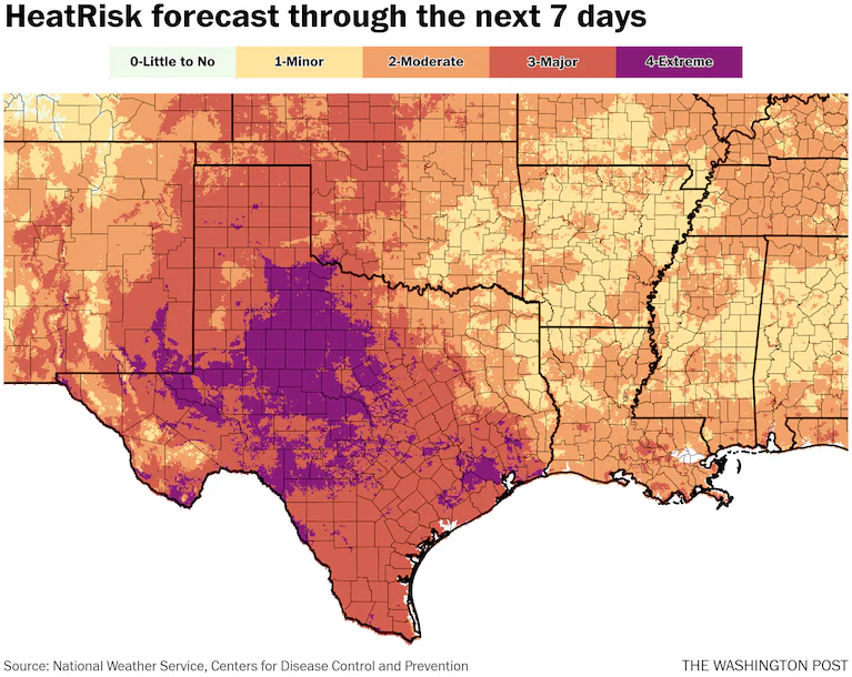
(Ian Livingston)
According to the HeatRisk outlook from government forecasters, much of the western half of Texas is expecting five to seven out of the next seven days to reach dangerous levels of major or extreme heat.
Dozens of daily record highs and record warm lows are likely to fall through at least this weekend. Temperatures between 100 and 110 are forecast to focus on the western and southern halves of Texas. Many places will remain around 75-to-80-plus degrees at night, with higher temperatures in large city centers or right on the toasty Gulf of Mexico.
Where is the heat most concentrated this week?
Two areas of scorching temperatures are the focus this week — much of Texas and into adjacent areas in the southern Plains, as well as in the Desert Southwest — with some bridge between them along the border with Mexico.
In and around Texas, above-average temperatures are nearly universal, with the hardest-hit spots observing readings some 10 to 15 degrees or more above average. This is ongoing Tuesday and lasts into the weekend while contracting in scope somewhat.
In Dallas, every day of the next week will see temperatures near or above 100. Areas west and north of there, including Wichita Falls and Abilene, may be subjected to nearly as long a run of highs of 105 to 110.
Around Houston, which saw temperatures reach and pass 100 in recent days, maximum heat indexes could be 115 or higher, while at night the temperatures will drop to only around 90 the next few nights. As the Gulf of Mexico sits around record levels of heat content, locations nearest it are also witnessing lengthy periods of extreme day and night heat.
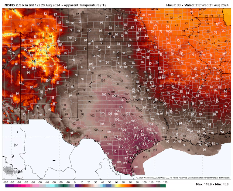
Heat index values Wednesday afternoon as forecast by the Weather Service. (WeatherBell)
Phoenix experienced a high of 112 on Monday, the 50th day at or above 110 this year, according to the Weather Service there. Temperatures will be similar Tuesday before dropping closer to 100 by late week.
Cooler air associated with a fall-like storm will bring temporary relief to the West Coast and southwest this weekend.
Where temperature records have been reached
Numerous daily temperature records were set beginning late last week, and more will be set throughout this week. Some of the recent records set include the highs below:
- Monday in Texas: Wichita Falls (111), Abilene (106), El Paso (104)
- Sunday: Scott City, Kan. (108, also Aug. record); Dodge City, Kan. (106); Little Rock (105)
- Saturday: El Paso (105), Baton Rouge (100), Albuquerque and Denver (98)
- Friday: Roswell and El Paso (105), Amarillo (103)
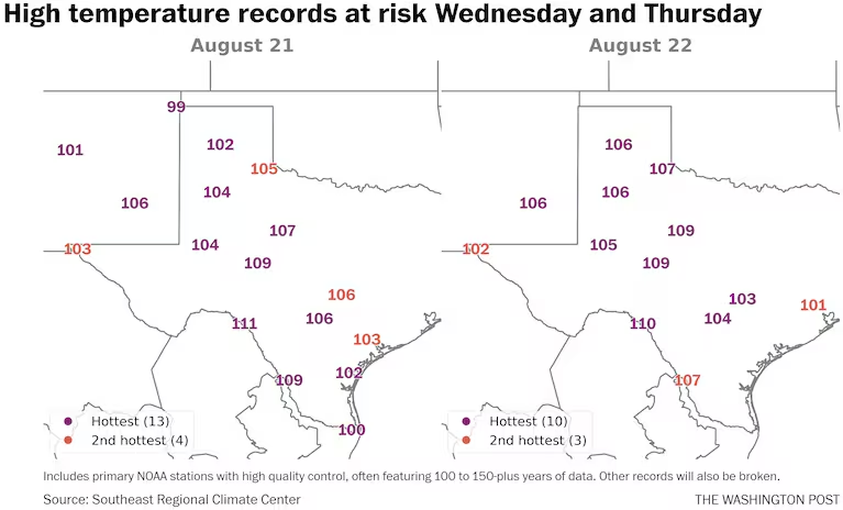
(Ian Livingston)
Through at least Friday, many of the long-term stations in central and west Texas into portions of New Mexico should see records threatened daily.
For instance, Amarillo and Lubbock in Texas and Roswell in New Mexico are all forecast to have record highs Wednesday through Friday, with each day and location around 105 to 110. Tuesday could also threaten high marks for the date.
In Phoenix, the streak of 85 days at or above 100 is the longest on record, beating 76 in 1992 and crushing 2023’s 66-day run.
It has so far been a near-record-hot August from around Las Vegas to west Texas. Swaths of both coasts and much of the southern United States are on target for the top five warmest summers on record.
Global temperatures also continue to run near record highs for the past 14 months, amid the waning effects of El Niño and boosted by human-caused climate change.
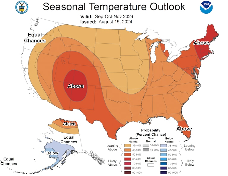
Temperature outlook for climatological fall. (Climate Prediction Center)
While both coasts of the Lower 48 should experience cooler weather for a time in the days ahead, the central and southern United States should continue to cook much of the next two weeks at the least.
Forecasters with the Climate Prediction Center released their fall outlook late last week. It looks a lot like what the country has been through the past couple months, with the greatest odds of above-average temperatures centered on the Four Corners region and covering much of the interior west to Texas.

By Ian Livingston Ian Livingston is a forecaster/photographer and information lead for the Capital Weather Gang. By day, Ian is a defense and national security researcher at a D.C. think tank. Twitter
Here are more “ETs” recorded from around the planet the last couple of days, their consequences, and some extreme temperature outlooks, as well as any extreme precipitation reports:
Here is more new August 2024 climatology (More July 2024 can be found on each prior daily post during August):
Here is More Climate News from Tuesday:
(As usual, this will be a fluid post in which more information gets added during the day as it crosses my radar, crediting all who have put it on-line. Items will be archived on this site for posterity. In most instances click on the pictures of each tweet to see each article. The most noteworthy items will be listed first.)