Thursday February 22nd… Dear Diary. The main purpose of this ongoing post will be to track United States extreme or record temperatures related to climate change. Any reports I see of ETs will be listed below the main topic of the day. I’ll refer to extreme temperatures as ETs (not extraterrestrials)😊. Here is today’s climate change related topic: February Flood and Warm Wave of 2018 Day Three
(If you like these posts and my work please contribute via the PayPal widget, which has recently been added to this site. Since I am a paraplegic I can definitely use any funds for medical expenses. Thanks in advance for any support.)
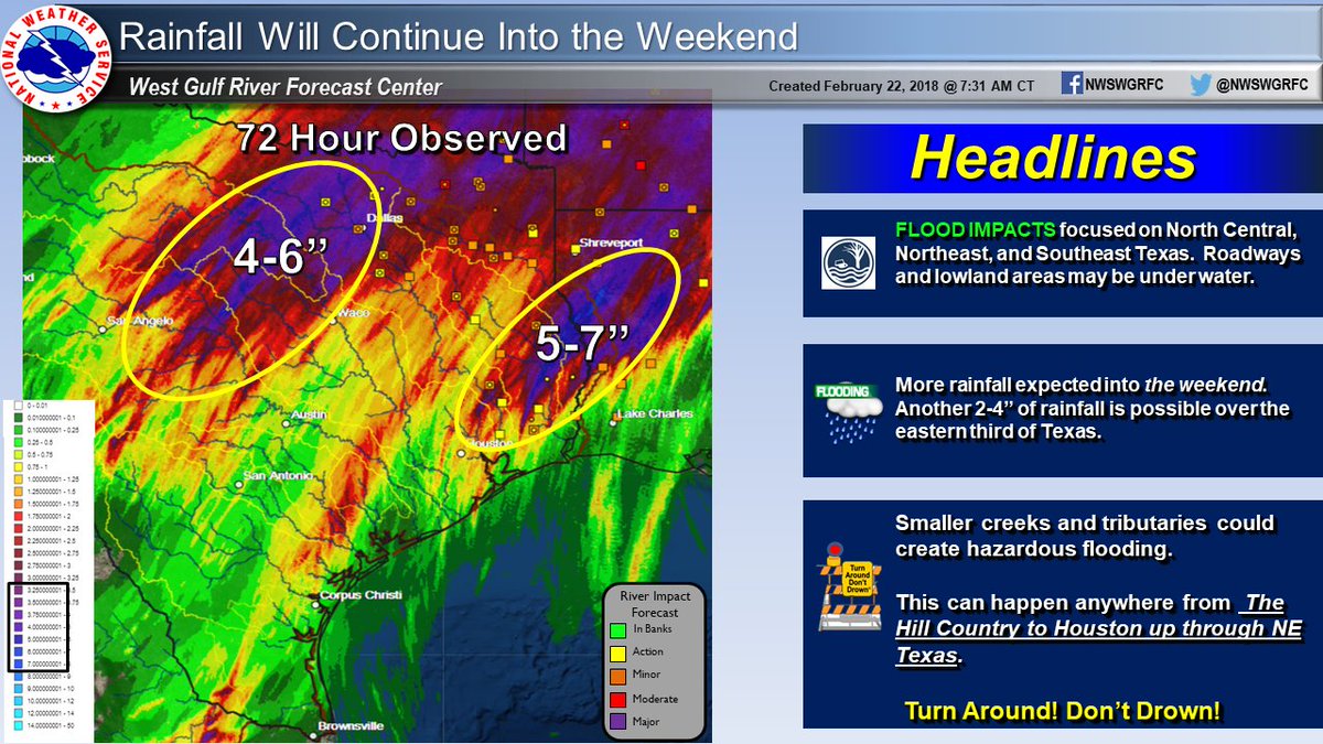
The good news today is that the flood in the Midwest hasn’t reached epic once in a hundred year levels. The bad news is that more rounds of heavy rain can be expected in the flood zone until our record ridge diminishes late on Saturday allowing a stalled front to move. First let’s look at how bad flooding has been so far. Here are some amounts from Texas:

According to The Weather Channel, “Water rescues were needed early Thursday in Bastrop, Louisiana, north-northeast of Monroe in north-central Louisiana. The town of Noble, Louisiana, picked up 8.58 inches of rain through Thursday morning, and Shreveport tallied 4 to 5 inches of rain from this event, so far.” Also from TWC:
As of midday Thursday, over 200 river gauges reported levels above flood stage, primarily from the Great Lakes to east Texas.
Already, six locations in northern Indiana and southern Michigan have set record river levels.
Among them, the St. Joseph River in South Bend, Indiana, surpassed its previous record crest of 10.9 feet from Jan. 6, 1993, and March 15, 1982.
So what do models have for the future of this flooding event? The GFS has a wide swath of over 2 inches of more rain in the same areas that have been hit with severe flooding:

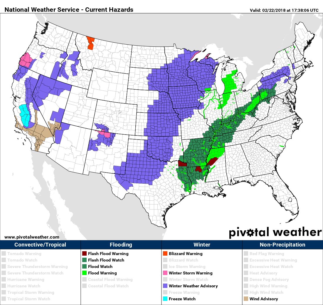
It’s no wonder that flood watches remain posted for much of the Ohio Valley and in the Mississippi Valley:

Frequently during the last year on this blog I’ve noted record high 500 millibar heights in association with global warming. Today Dr. Jeff Masters of Weather Underground posted a good write up on the February heat and associated weather. He included some impressive 500 mb statistics:
https://www.wunderground.com/cat6/summer-february-80-massachusetts-78-nyc
To verify just how unusual this ridge was, Lance Bosart (University at Albany, State University of New York) dug through the radiosonde climatology compiled by the NOAA/NWS Storm Prediction Center. The dataset goes back to the start of routine radiosonde launches in the late 1940s. At nearly every site along the U.S. East Coast, the weather balloons launched at 12Z Wednesday found a 500-mb surface higher than anything on record for January or February—and in some cases across even longer seasonal spans, as shown below.
GYX (Gray/Portland, ME): 581 decameters (prev. Feb record 578 dm; record for late Nov > late Mar)
CHH (Chatham, MA): 586 dm (prev. Feb record 580 dm; record for late Nov > mid Apr)
OKX (Brookhaven, NY): 588 dm (prev. Feb record 581 dm; record for late Nov > late Apr)
IAD (Sterling, VA): 588 dm (prev. Feb record 581 dm; record for late Nov > mid Apr)
WAL (Wallops Island, VA): 590 dm (prev. Feb record 586 dm; record for early Dec > late Apr)
MHX (Morehead City, NC): 595 dm (prev. Feb record 591 dm; record for early Oct > late May)
CHS (Charleston, SC): 594 dm (prev. Feb record 593 dm; record for early Dec > early May)
JAX (Jackson, MS) 594 dm (prev. Feb record 592 dm; record for mid-Nov > early May)
XMR (Cape Canaveral, FL): 595 dm (prev. Feb record 591 dm; record for mid Dec > early Mar)
 |
| Figure 3. Locations that recorded an all-time record ridge of high pressure at 12Z (7 am EST) Febraury 21, 2018, according to 500 mb height measurements made by balloon-borne radiosonde instruments. Radiosonde records extend back to the late 1940s. |
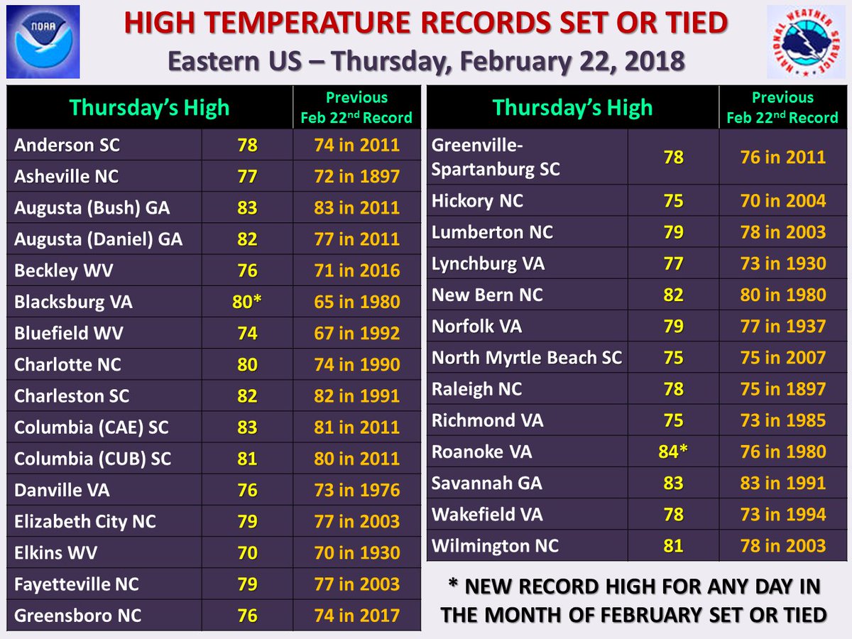
This was the third consecutive day of record warmth in the South and East. Here are some of the major reports:
 NWS Eastern RegionVerified account @NWSEastern

I’m also including reports from the state of Georgia. Atlanta, my home city, broke its record by a whopping five degrees:
Atlanta broke the daily high-temperature record today reaching 79 degrees. This shatters the previous daily high-temperature record by 5 degrees! (74 set back in 2003).
 NWS AtlantaVerified account @NWSAtlanta
I may add more relevant information later tonight.
The Climate Guy

When I originally commented I clicked the “Notify me when new comments are added” checkbox and now each time a comment is added I get several e-mails with the
same comment. Is there any way you can remove me from that
service? Bless you!
meilleur casino en ligne
It’s truly a great and helpful piece of info. I am
happy that you simply shared this helpful info with us.
Please stay us up to date like this. Thank you for
sharing.
casino en ligne
We’re a gaggle of volunteers and starting a new scheme
in our community. Your web site provided us with useful info to work on. You
have performed a formidable task and our entire group might be thankful to you.
casino en ligne
I every time spent my half an hour to read this website’s articles
all the time along with a mug of coffee.
casino en ligne
Good day! I could have sworn I’ve been to this site before but
after reading through some of the post I realized it’s new to me.
Anyhow, I’m definitely delighted I found it and I’ll be bookmarking and checking back often!
casino en ligne
Howdy! Someone in my Myspace group shared this website with us so
I came to check it out. I’m definitely enjoying the information.
I’m bookmarking and will be tweeting this to my followers!
Wonderful blog and outstanding design and style.
casino en ligne
Hi, yup this paragraph is genuinely good and I have learned lot
of things from it about blogging. thanks.
casino en ligne
Hi, I read your new stuff daily. Your story-telling style is awesome, keep it up!
casino en ligne
Hello, i think that i saw you visited my site thus i came to “return the favor”.I’m trying
to find things to improve my site!I suppose its ok to use a few of your ideas!!
casino en ligne
It’s a pity you don’t have a donate button! I’d definitely
donate to this superb blog! I guess for now i’ll settle for bookmarking and
adding your RSS feed to my Google account. I look forward to new updates and will share this site with my Facebook group.
Chat soon!
casino en ligne