The main purpose of this ongoing blog will be to track planetary extreme, or record temperatures related to climate change. Any reports I see of ETs will be listed below the main topic of the day. I’ll refer to extreme or record temperatures as ETs (not extraterrestrials).😉
Main Topic: Connecting Rising Global Heat with Catastrophic Flooding
Dear Diary. We know by now that a warming planet will lead to more retention of water vapor in our atmosphere due to our carbon pollution. When atmospheric disturbances interact with this increased water vapor, heavier precipitation can fall. Such has been the case from August into September.
Here are four cases via the Washington Post:
How rising global heat connects catastrophic floods on four continents – The Washington Post
How rising global heat connects catastrophic floods on four continents
At this time of year, that flood potential amped up by global warming can become especially evident.
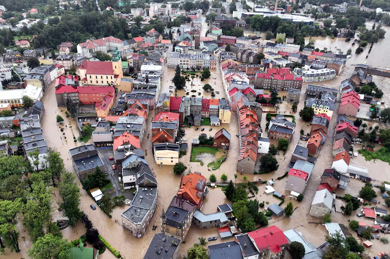
An aerial photograph taken on Sunday shows a view of the flooded city center in Glucholazy in southern Poland. (Sergei Gapon/AFP/Getty Images)

By Scott Dance
September 19, 2024 at 1:38 p.m. EDT
Within weeks, catastrophic floods swept across four continents.
Typhoons triggered landslides across Southeast Asia and inundated Shanghai. A slow-moving storm, unusual for this time of year, sent a deluge over Central Europe. Months of floods wore on in northern and central Africa as rain continued to fall on landscapes that are normally more arid. And in the United States, a tropical system too disorganized to become a named storm nonetheless poured historic rainfall on the Carolinas, with more than 20 inches landing in some spots.
Research quickly began to determine the degree to which a human-caused rise in global temperatures made some of these downpours more intense, though results are not yet available. But scientists said the fingerprints are already clear.
Warmer air can hold more moisture, allowing precipitation to fall that much more heavily. And the effect is not uniform around the planet — at times,it can be less perceptible, while in other cases, it’s impossible to ignore, said Kelly Mahoney, who studies extreme precipitation at the National Oceanic and Atmospheric Administration’s Physical Sciences Laboratory.
“The climate is changing, and it’s amplifying extremes,” she said.
At this time of year, that amped-up flood potential can become especially evident. It is prime season for hurricanes and typhoons, and while the Atlantic has remained relatively calm, exceptional ocean heat is helping fuel an active season in the Pacific, including some historic recent cyclones. And as fall approaches in the Northern Hemisphere, it is bringing clashes between moist summer air that is still in place and frontal systems that are ushering in cooler and drier conditions, while wringing the atmosphere of that copious water vapor.
A similar spate of floods last September also underscored how ever-warmer and more humid air can transform heavy rainstorms into historic ones.
“That’s just one of the hallmarks of climate change,” Mahoney said.
The recent flooding impacts were widespread and dramatic.
In Asia, Typhoon Yagi became the year’s most intense super typhoon before making landfall in China on Sept. 6 and northern Vietnam on Sept. 7 and bringing torrential rains into Laos and Myanmar, where it converged with monsoon rains to trigger landslides that buried entire villages. The storm killed dozens in the Philippines and Thailand, and nearly 300 people each in Vietnam and Myanmar — whose junta government made a rare appeal for international aid — according to a Wednesday update from the ASEAN Coordinating Center for Humanitarian Assistance on Disaster Management.
Then on Monday, Typhoon Bebinca became the strongest storm to strike Shanghai since 1949. Abnormally warm waters around 30 degrees Celsius (86 degrees Fahrenheit) — as much as 3 degrees C (5.4 degrees F) above average for this time of year — helped fuel the unusually strong storm, which was the equivalent of a Category 1 hurricane. Chinese state media reported hundreds of downed trees in Shanghai and power outages affecting more than 30,000 households.
Tropical Storm Pulasan was hitting many of the same areas on Thursday.
The China Meteorological Administration warned that while typhoons are more frequent during summer months, they are more likely to become severe and trigger the heaviest rainfall in the fall, when colder air can clash with the tropical moisture.
In Europe, a similar contrast was fueling rain that has lingered over the continent for nearly a week. After Arctic air plunged southward to meet Mediterranean warmth, catastrophic floods and heavy snow inundated parts of Austria, the Czech Republic, Germany, Hungary, Poland, Romania and Slovakia. At least 19 people died and thousands were forced to vacate their homes in Central and Eastern Europe.
The system, which became cut off from the steering influence of the jet stream, has since meandered to northern Italy, where widespread rain totals of 4 to as much as 10 inches caused severe flooding Wednesday.
Joyce Kimutai, a researcher at Imperial College London’s Grantham Institute on climate change and environment, said it was exactly the sort of hazard that scientists have predicted for Europe as the climate warms. Weather data shows September rainfall has been steadily increasing in the region since 1950, she said.
“Floods like these can kill dozens of people and cause damages worth billions of euros, and they will keep getting worse until we replace fossil fuels with cleaner, renewable sources of energy,” Kimutai said in a statement.
The Grantham Institute’s world weather attribution initiative said it launched what is known as an attribution study focused on the floods in Europe, as well as in Africa. Such research can determine the extent to which climate change made an event more likely, or more extreme.
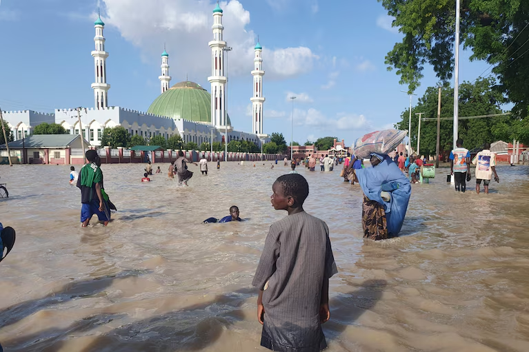
People walk through floodwaters following a dam collapse in Maiduguri, Nigeria, on Sept. 10. (Joshua Olatunji/AP)
In northern and western Africa, floods were affecting more than 4 million people in 14 countries, including Chad, Liberia, Mali, Niger and Nigeria — where the U.N. refugee agency said the death toll is approaching 300 and the number of people displaced from their homes has reached 640,000. The floods have compounded years of crisis and food insecurity in many areas, Arjun Jain, Nigeria’s representative to agency, told reporters at a briefing in Geneva.
“Communities which, after years of conflict and violence, had started rebuilding their lives were struck by the floods and once again displaced,” he said.
The devastation underscores what has been an unusual year for African monsoon rains that normally fall on sub-Saharan parts of western and central Africa from June through September. They have poured much farther north than usual — NASA satellite analysis found evidence of a year’s worth of rainfall in parts of the Sahara desert, filling basins that are normally empty and where scientists have observed lakes only a handful of times.
That has had impacts across the Atlantic, contributing to a quieter-than-expected hurricane season. Waves of unsettled weather that flow westward from Africa often form the seeds of powerful hurricanes, but the northward shift in the monsoon has meant those systems are entering less-hospitable Atlantic waters.
That hasn’t entirely prevented torrential tropical rains in the United States. Hurricane Beryl, which in July became the earliest Category 5 storm on record in the Atlantic basin, stressed Houston’s beleaguered flood infrastructure.
And then a system that nearly became a tropical storm, which would have given it the name Helene, slowed against a stalled frontal boundary as it approached the Carolinas. Accelerated warming in polar regions has been causing tropical systems to move more slowly in recent decades, and new research stresses the danger that poses to the southeast U.S. coast, as well as the Gulf Coast and other regions.
In this case, the slow movement allowed the storm to dump rain at rates of as much as 3 inches per hour.
That further exemplified the dangers of an atmosphere carrying higher and higher levels of moisture as temperatures warm, Mahoney said.
Such a tropical system is common this time of year, and on its own would surely have been impactful, she said. But with extra moisture and the influence of a frontal boundary squeezing out more rain and slowing the system down, it became extreme.
“The combination made it go from medium-impact to devastating in some areas,” she said.
Pei-lin Wu in Taipei, Taiwan, and Rebecca Tan in Singapore contributed to this report.

By Scott Dance Scott Dance is a reporter for The Washington Post covering extreme weather news and the intersections between weather, climate, society and the environment. He joined The Post in 2022 after more than a decade at the Baltimore Sun. Follow on X ssdance
Here are more “ETs” recorded from around the planet the last couple of days, their consequences, and some extreme temperature outlooks, as well as any extreme precipitation reports:
Here is more new August 2024 climatology. (More can be found on each daily post during September.):
Here is More Climate News from Saturday:
(As usual, this will be a fluid post in which more information gets added during the day as it crosses my radar, crediting all who have put it on-line. Items will be archived on this site for posterity. In most instances click on the pictures of each tweet to see each article. The most noteworthy items will be listed first.)