The main purpose of this ongoing blog will be to track planetary extreme, or record temperatures related to climate change. Any reports I see of ETs will be listed below the main topic of the day. I’ll refer to extreme or record temperatures as ETs (not extraterrestrials).😉
Main Topic: U.S. October 2024 Record Scoreboard and Climatological Review
Dear Diary. It’s past time for our monthly climatological review because of the effects from Helene on the National Center for Environmental Information in Asheville North Carolina. Thankfully they have recovered. Here on this site, we usually present monthly summaries near the 10th of each month, and each is available by clicking the link below:
https://guyonclimate.com/category/record-scoreboard-climatological-reviews
I’m repeating this mantra every month:
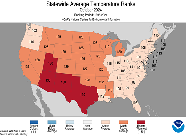
October 2024 using 1901-2000 mean data got ranked by the National Center for Environmental Information for the lower 48 states as 2nd warmest or 129th coolest since records began being kept in 1895 at +4.88°F(2.91°C) above average. Only October 1963 was warmer.
The above data was from:
https://www.ncdc.noaa.gov/cag/national/rankings
October was very warm relative to temperature averages for the majority of U.S. states. Most reports of record heat came from the Southwest, south-central states, Midwest, Northeast, and Florida throughout the month. Most reports of record chill came from the Pacific Northwest, Rockies and southern portion of the Midwest the third week of the month.

Several southwestern states and Texas had their hottest Octobers on record. No one state had below average temperatures.
You can check out record totals for yourself on my NCEI record archives:
NCEI Record Count Archive – Guy On Climate
Here are my two U.S. Daily Record Scoreboards updated through 11/08/2024 (data compiled from the following NCEI site):
https://www.ncdc.noaa.gov/cdo-web/datatools/records
I’m also keeping tabs on record report totals to verify a scientific study I helped to complete in the decade of the 2000s. We’ll eventually see how skewed ratios of record warm to cold reports get by the year 2100, which the study mentions as 50-1 for DHMX vs. DLMN:
Brand new for 2024: I’ve started to add NCEI anomalies (F° departure from 1901-2000 data) on my record scoreboards. I’d like these record scoreboards to be a quick and dirty reference tool and a template for future NCEI record site graphics.


DHMX= Daily High Max Reports. DLMN= Daily Low Min Reports. DHMN= Daily High Min Reports. DLMX=Daily Low Max Reports.
Boldly highlighted red, blue, or purple colored months, such as December 2023 and June 2021, that have ratios of >10 to 1 daily warm low records or <1 to 10 daily warm to low records are either historically hot or cold, most of which have made news. NCEI rankings are for the lower 48 states with the warmest ranking since 1895 of average temperatures being 130 and 1 being the coldest as of 2024. Blue colors represent cold months and red warm. Those months and years with counts close to a 1 to 1 ratio of highs to lows are colored black. All-time record hottest or coldest months and years are boldly colored in purple. NCDC rankings have been color coded (under tabs in each file) such that values of 54 to 74 are black representing neutral months or years (+ or – 10 from the average ranking of 64).
Totals are record reports for the entire United States including all territories minus those from Alaska. I’ve subtracted those from Alaska to get a better representation of what has occurred across the lower 48 states in association with lower 48 state rankings.
October 2024 had approximately a 15 to 1 ratio of record DHMX to DLMN individual record counts, so the color I used for that month was bold red on the top chart.
October 2024 had approximately a 12 to 1 ratio of record DHMN to DLMX individual record counts, so the color I used for that month was bold red on the bottom chart.
Due to climate change, we are seeing fewer blue colors on these Record Scoreboards with time.
The average temperature lower 48 state ranking for October 2024 was 129, which was colored red since it was warmer than average.
I color rankings of +10 to -10 from the average ranking for the lower 48 states of 65 black, indicating that these are near average temperature wise. The top warmest ranking for 2024 would be 130 since rankings began in 1895.
We are seeing that so far November 2024 has been well above average for most of the country except the Southwest and Rockies, which just saw its first major winter storm. November 2024 should be above average for the lower 48 states as a whole, perhaps cracking another top twenty ranking looking at meteorological models.
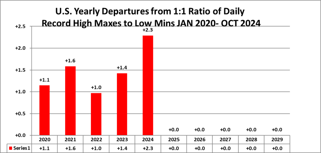
Interestingly, overall ratios for 2024 are now higher than historic yearly ratios for other years from the 2020s as shown here…which is no surprise given how hot the globe is during this record hot year thanks to climate change:


Here is much more detailed climatology for October 2024 as complied by NOAA:
Assessing the U.S. Climate in October 2024
Rapid/Record drought expansion across the contiguous U.S. during October; Near-record warm and dry conditions dominate large portions of the Lower 48

Courtesy of GettyImages
Published
November 8, 2024
Related Links
October 2024 U.S. Climate Report (Available November 14, 2024)
National Temperature and Precipitation Maps
Climatological Rankings Explained
State of the Climate Summaries
Key Points:
- On October 29, the U.S. Drought Monitor noted that 87.16% of the contiguous U.S. was experiencing abnormally dry to exceptional drought conditions, a record in the program’s 25-year history.
- Despite Hurricane Helene causing record wet conditions across much of the Southeast in late September, record to near-record dryness in October resulted in the return of drought or abnormally dry conditions across the region.
- October 2024 was second warmest and tied for second driest on record for the nation.
- Year-to-date temperatures were second warmest for the contiguous U.S., with most of the record heat concentrated from the Great Lakes to the Northeast.
Other Highlights:
Temperature

The average temperature of the contiguous U.S. in October was 59.0°F, 4.9°F above average, ranking second warmest in the 130-year record. Generally, October temperatures were record warm across portions of the West and Deep South with above average temperatures dominating much of the remainder of the contiguous U.S. Utah, Arizona, New Mexico and Texas each ranked warmest on record for October, while California, Montana, Wyoming and Colorado each ranked second warmest on record. An additional 10 states ranked in their top-10 warmest October on record.
The Alaska statewide October temperature was 27.8°F, 2.3°F above the long-term average, ranking in the middle third of the 100-year period of record for the state. Near-normal temperatures were observed across much of the state with above-normal temperatures concentrated across parts of the North Slope, West Coast, Aleutians and Northeast Gulf regions.

For January–October, the average contiguous U.S. temperature was 58.3°F, 3.3°F above average, ranking second warmest on record for this period. Temperatures were above average across the Lower 48 with record warmth concentrated across portions of the Southwest and from the Upper Midwest to the Ohio Valley and into the Northeast. New Mexico, Wisconsin, Michigan, Ohio, West Virginia, Virginia, Pennsylvania, New York, Vermont, New Hampshire and Maine each experienced their warmest January–October on record. An additional 35 states had a top-10 warmest year-to-date period.
The Alaska January–October temperature was 32.0°F, 2.4°F above the long-term average, ranking in the warmest third of the historical record for the state. Much of the state was above normal for this 10-month period while temperatures were near average across much of the Panhandle and portions of south central and eastern interior regions.
Precipitation

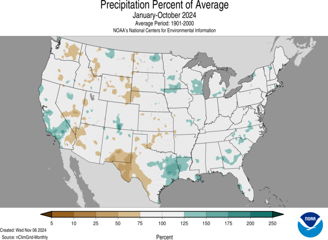
October precipitation for the contiguous U.S. was 0.95 inch, 1.21 inches below average, tying for second driest with October 1963. Precipitation was below average across much of the Lower 48 with pockets of above-average precipitation across portions of the Rockies and Florida. Delaware and New Jersey both had their driest October on record. Nineteen additional states from Texas to the Northeast had a top-10 driest October on record for this period.
Across the state of Alaska, the average monthly precipitation was 4.04 inches, ranking in the middle third of the historical record. Precipitation was above average across portions of the North Slope and Central Interior regions and near average across portions of Cook Inlet and the Panhandle. Below-average precipitation occurred across portions of the West Coast, Bristol Bay, the Aleutians and the Southeast Interior regions during the month.

The January–October precipitation total for the contiguous U.S. was 26.17 inches, 0.83 inch above average, ranking in the wettest third of the 130-year record. Precipitation was near to above average across portions of the West Coast, Great Lakes, Deep South and from Florida to the Northeast. Louisiana ranked 10th wettest for this 10-month period. Conversely, precipitation was below average across parts of the Northwest, northern Rockies and Plains, Southwest, central Plains and Ohio Valley.
The January–October precipitation ranked in the wettest third of the 100-year record for Alaska, with above-average precipitation observed across much of the North Slope, West Coast and in parts of the Central Interior region and southern coastal communities. Precipitation across the Panhandle ranged from below average to slightly above average for this 10-month period.
Other Notable Events
Persistent heat and dry conditions caused rapid expansion of drought, setting records across the U.S. in October:
- At least a half-dozen long-term stations across the Mid-Atlantic, including Philadelphia, Newark, Trenton, Norfolk and Wilmington, Delaware, set records for the number of consecutive days without measurable precipitation from late September through early November.
Hurricane Milton, which was included in the Billion Dollar Weather and Climate Disaster count update released in late October, made landfall near Tampa, Florida, as a Category 3 storm on October 9, less than two weeks after Hurricane Helene made landfall about 200 miles to the north. More than 100 tornadoes were spawned across Florida and millions were without power as a result of the storm.
- Hurricane Milton rapidly intensified into a Category 5 storm in the Gulf of Mexico and became the Gulf’s strongest late-season storm on record and the fifth-most-intense Atlantic hurricane on record.
Drought
According to the October 29 U.S. Drought Monitor report, about 54.1% of the contiguous U.S. was in drought, up about 22.6% from the beginning of October—the largest four-week drought expansion on record. Moderate to exceptional drought was widespread from the Deep South to the northern Plains, across much of the Great Lakes, and in portions of the Northwest, Southwest, Northeast and across much of Hawaii.
Drought conditions expanded or intensified across nearly all of the regions already experiencing drought due to the dry and warm conditions throughout much of the month.
Monthly Outlook
According to the October 31 One-Month Outlook from the Climate Prediction Center, above-normal monthly average temperatures are favored across much of the eastern U.S. and northern Alaska. Portions of the central Plains and Midwest are favored to see above-normal monthly total precipitation. Drought improvement or removal is forecast from the southern Plains to the Great Lakes and across parts of Hawaii, while persistence is more likely across the Northwest, Southwest, northern Plains and Rockies and across portions of Texas, the Gulf Coast and portions of the Northeast. Drought development is likely in parts of the Southeast.
According to the One-Month Outlook issued on November 1 from the National Interagency Fire Center, above-normal significant wildland fire potential exists from the central Gulf Coast states to southern New England during November.
This monthly summary from NOAA’s National Centers for Environmental Information is part of the suite of climate services NOAA provides to government, business, academia and the public to support informed decision-making. For more detailed climate information, check out our comprehensive October 2024 U.S. Climate Report scheduled for release on November 14, 2024. For additional information on the statistics provided here, visit the Climate at a Glance and National Maps webpages.
More:
Here are more “ETs” recorded from around the planet the last couple of days, their consequences, and some extreme temperature outlooks, as well as any extreme precipitation reports:
Here is more brand-new October 2024 climatology (More can be found on each past archived daily November post.):
Here is More Climate News from Friday:
(As usual, this will be a fluid post in which more information gets added during the day as it crosses my radar, crediting all who have put it on-line. Items will be archived on this site for posterity. In most instances click on the pictures of each tweet to see each article. The most noteworthy items will be listed first.)
BTW The often quoted MR Mann blocked me from his x account because I also asked him why he is cutting down trees for his for-profit musings if he were so concerned about climate change?
I find it laughable because his lead post is selling his paperback book and probably doesn’t want to affect his aura when I so graciously pulled back the curtain and showed the world some true colors. My only question,after blocking me, is how did he earn his last name?