The main purpose of this ongoing blog will be to track planetary extreme, or record temperatures related to climate change. Any reports I see of ETs will be listed below the main topic of the day. I’ll refer to extreme or record temperatures as ETs (not extraterrestrials).😉
Main Topic: Philippines Raked by Record Breaking Typhoon Season
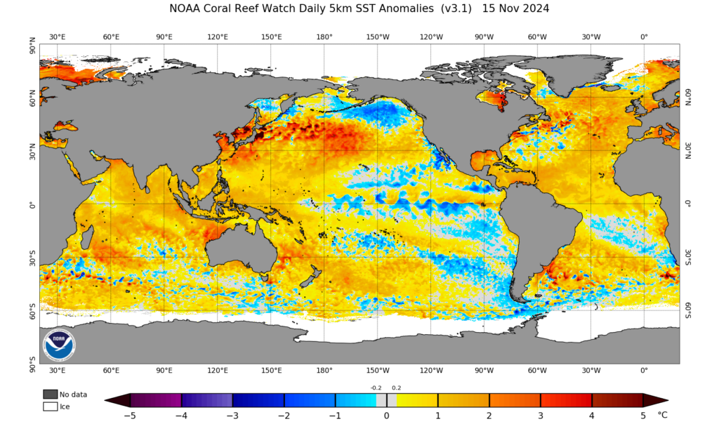
Dear Diary. Due to where the Philippines is located, the chain of islands is no stranger to typhoon activity. I’ve included plenty of notes on typhoons in my news section over the years, but those from 2024 take the proverbial cake. Obviously, climate change has been a factor since Pacific Ocean water temperatures are near record warm levels across hundreds of miles surrounding the island nation, particularly east of the Philippines along traditional tracks for typhoons:
Here are many more details from Carbon Brief:
12 December 2024
Record-breaking Philippines typhoon season was ‘supercharged’ by climate change
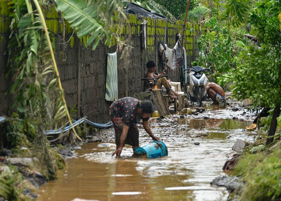
Residents cleaning the mud after tropical storm Kristine flooded Lemery, Philippines, 25 October 2024. Credit: ZUMA Press, Inc. / Alamy Stock Photo
This year’s record-breaking typhoon season in the Philippines – which saw six consecutive storm systems hit the country in under a month – was “supercharged” by climate change, according to a rapid attribution study.
The Philippines is one of the most vulnerable countries in the world to extreme weather. Between late October and mid November 2024, the country was hit by a barrage of storms, starting with severe Tropical Storm Trami on 22 October, and ending with Tropical Storm Man-Yi which made landfall on 16 November.
“Typhoon” is the term used to describe a tropical cyclone – a tropical storm with wind speeds of at least 33 metres per second – that forms in the north-west Pacific. (If a tropical cyclone forms in the Atlantic Ocean or north-eastern Pacific Ocean, it is called a hurricane.)
Even for a disaster-prone country, such rapid “clustering” of typhoons was “unprecedented”, one Filipino expert told a press briefing.
By the end of November 200,000 individuals were displaced across six regions – many of whom had been forced from their homes multiple times in just one month.
The World Weather Attribution (WWA) service finds that climate change has exacerbated the conditions that enabled these powerful storms to form in the Philippine Sea, such as warm seas and high humidity.
Of the six major storms that hit the Philippines between the end of October and middle of November this year, three made landfall as “major typhoons” with wind speeds above 50 metres per second (112 miles per hour). This is 25% more likely to happen in today’s climate than it would have been in a pre-industrial world without human-caused warming, the study finds.
The typhoons “highlight the challenges of adapting to back-to-back extreme weather events”, the study says. The authors add that “repeated storms have created a constant state of insecurity, worsening the region’s vulnerability and exposure”.
‘Unprecedented’ typhoon season
On 22 October 2024, severe Tropical Storm Trami made landfall on the Filipino island of Luzon – the country’s largest and populous island. The storm rapidly dumped one month’s worth of rain over parts of the island, with floods sweeping the country.
However, the residents were given little time to recover. Just days after Storm Trami subsided, the Philippines was hit by Super Typhoon Kong-Rey. More than nine million people were affected by the two storms and almost 300,000 displaced.
As the weeks progressed, the Philippines was hit by Typhoon Yinxing, Typhoon Toraji and Typhoon Usagi. Finally, Tropical Storm Man-Yi made landfall on 16 November, marking the end of the record-breaking month.
Afrhill Rances works at the Asia-Pacific regional office of the International Federation of Red Cross and Red Crescent Societies, and is an author on the WWA study. She told a press briefing that, even for a disaster-prone country, the rapid “clustering” of typhoons in 2024 was “unprecedented”.
Dr Claire Barnes – a research associate at Imperial College London’s Grantham Institute and an author on the study – added that in the Philippines, “in November we would expect to see only three named storms in the entire basin at any point, with only one of those reaching super typhoon status”. A super typhoon is defined as any typhoon with winds above 58 metres per second (130 miles per hour).
The back-to-back storms formed so rapidly that November saw four named storms forming in the Pacific basin simultaneously. Japan’s meteorological agency said this was the first time in seven years – and the first November in recorded history – where four named storms have formed in the Pacific at the same time.
Typhoon intensity
Typhoons are complex events, which can be intensified by climate change in many different ways, including their rainfall intensity, storm surge height and wind speed.
The authors of this study focus on a metric called “potential intensity”, which looks at temperature, humidity levels and sea level pressure over the Philippine Sea where the typhoons formed.
Ben Clarke, a study author from the Centre for Environmental Policy at Imperial College London, told the press briefing that potential intensity indicates the “theoretical maximum intensity for a tropical cyclone”. He explains that the metric is “based on the conditions in the atmosphere and the ocean which are crucial for cyclone development”.
The map below shows the average potential intensity of the Philippine Sea between September and November 2024, where red indicates high potential intensity and blue indicates low potential intensity.
The dotted lines show the tracks of different storms. The black square indicates the study area. Potential intensity is calculated as the potential wind speed of the typhoon in metres per second.
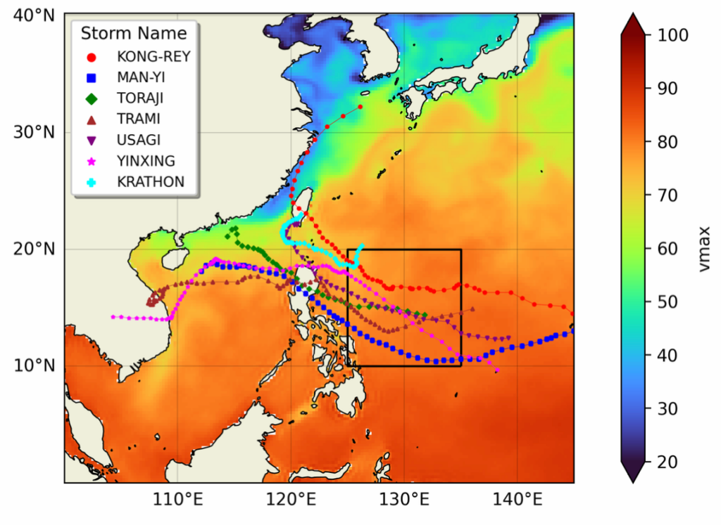
Average potential intensity in the Philippine Sea over September-November 2024, using ERA5 data. Source: WWA (2024).
To put this year’s record-breaking typhoon season into its historical context, the authors analysed a time series of average potential intensity in the Philippine Sea, using an observational reanalysis dataset stretching back to the year 1940.
The study says:
“Our best estimate is that the observed potential intensity has become about 7 times more likely and the maximum intensity of a potential typhoon has increased by about 4 metres per second.”
The authors also carried out attribution analysis to assess whether the increase in potential intensity can be linked to human-caused climate change.
Attribution is a fast-growing field of climate science that aims to identify the “fingerprint” of climate change on extreme-weather events, such as heatwaves and droughts. To conduct attribution studies, scientists use models to compare the world as it is today to a “counterfactual” world without human-caused climate change.
The authors find that the potential intensity in the Philippine Sea in 2024 was 1.7 times higher than it would have been in a world without climate change. They add that the maximum potential intensity of a typhoon has increased by about 2 metres per second due to climate change.
(These findings are yet to be published in a peer-reviewed journal. However, the methods used in the analysis have been published in previous attribution studies.)
Landfall
Climate change is exacerbating the conditions needed for tropical cyclones to form. However, tropical cyclones are still fairly infrequent and there is a “short period of reliable observations” of tropical cyclones that make landfall, according to the study.
This can make it challenging for scientists to assess the impact of climate change on the frequency of tropical cyclones using traditional methods.
To address this problem, researchers from Imperial College London developed a “synthetic tropical cyclone dataset” called IRIS earlier this year. This dataset uses observations from 42 years of observed tropical cyclones to create a “10,000-year synthetic dataset of wind speed”.
The database includes millions of synthetic tropical cyclone tracks. Each track maps the wind speed of the tropical cyclone from its formation to its landfall, to describe how its power changes throughout its lifetime.
The team has already used this method to attribute the extreme winds of Typhoon Geami and Hurricane Beryl, which hit China and Jamaica, respectively, earlier this year.
Of the six major storms that affected the Philippines in the month-long period, three made landfall as “major typhoons”, according to the WWA. The authors define a major typhoon as a category three or above, indicating sustained wind speeds above 50 metres per second.
Using the IRIS dataset, the authors assessed how likely it is for three typhoons to make landfall in the Philippines in a single year under different warming levels. They find that in today’s climate – which has already warmed by 1.3C as a result of climate change – the Philippines could expect three major typhoons to make landfall in a single month roughly once every 15 years. This is 25% more frequent than in a world without climate change.
They add that if the planet warms to 2C above pre-industrial temperatures, “we expect at least three major typhoons hitting in a single year every 12 years”.
‘Supermarket of disasters’
The Philippines is one of the most vulnerable countries in the world to extreme weather events and natural disasters and is already facing deadly impacts from climate change.
The country’s location in the Pacific Ocean makes it highly vulnerable to typhoons, volcanoes and earthquakes. The WWA study adds that the country “is experiencing sea level rise more than three times faster than the global average”. And the Philippines is facing deadly heatwaves, which have been made more intense as a result of climate change.
Rances told the press briefing:
“In the Red Cross we call the Philippines a ‘supermarket of disasters’, because you name it – we have it.”
The Philippines is struck by more typhoons every year than almost any other country in the world. It has “gradually shifted its approach from reactive to proactive risk management with a significant focus on preparedness and resilience building”, according to the World Bank.
For example, warning and pre-emptive evacuation orders were sent out ahead of many of the typhoons this year. Schools, ports and airports were closed in many regions. And disaster response teams were mobilised.

Families seeking shelter at the Bagong Silangan Evacuation Center, Philippines, due to the expected flooding in low-lying areas caused by Super Typhoon Man-yi, local name Pepito, on 17 November 2024. Credit: Imago / Alamy Stock Photo.
However, the unrelenting barrage of typhoons this year overwhelmed many of the country’s disaster preparedness systems, exhausting supplies and overstretching emergency responders. It also left communities with little time between storms to recover and prepare.
The United Nations Office for the Coordination of Humanitarian Affairs estimates that, at the end of November 2024, more than 200,000 individuals were displaced across six regions, hundreds of fatalities and injuries had been reported and more than 250,000 homes had been damaged. The damage to livestock, agriculture and infrastructure was estimated to be around $47m at the end of November.
The Filipino government spent more than $17m on food and other aid for the hundreds of thousands of storm victims. It has also sought help from neighbouring countries, the US and the United Nations.
The consecutive typhoons “highlight the challenges of adapting to back-to-back extreme weather events”, the study says. It adds:
“With 13 million people impacted and some areas hit at least three times, repeated storms have created a constant state of insecurity, worsening the region’s vulnerability and exposure.”
The authors warn that “major investment is needed to help the Philippines adapt to extreme weather”
More recent Carbon Brief articles:

Q&A: The evolving science of ‘extreme weather attribution’
Attribution|
18.11.24
Mapped: How climate change affects extreme weather around the world
Attribution|
18.11.24
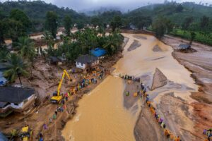
Climate change made ‘monsoon downpour’ behind Kerala landslides 10% more intense
Attribution|
14.08.24

Climate change made the ‘supercharged’ 2024 Pantanal wildfires 40% more intense
Attribution|
08.08.24
Here are more “ETs” recorded from around the planet the last couple of days, their consequences, and some extreme temperature outlooks, as well as any extreme precipitation reports:
Here is More Climate News from Sunday:
(As usual, this will be a fluid post in which more information gets added during the day as it crosses my radar, crediting all who have put it on-line. Items will be archived on this site for posterity. In most instances click on the pictures of each tweet to see each article. The most noteworthy items will be listed first.)