The main purpose of this ongoing blog will be to track planetary extreme, or record temperatures related to climate change. Any reports I see of ETs will be listed below the main topic of the day. I’ll refer to extreme or record temperatures as ETs (not extraterrestrials).😜
Main Topic: Heatwave Pemex Peaks in the West as Large Blases Roar
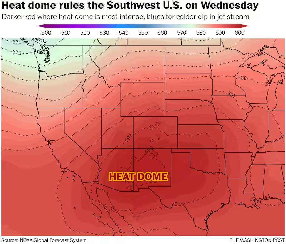
Dear Diary. The heatwave that I’ve dubbed Pemex is having a second peak across the western U.S. and is a high end CAT3 by my estimates today. This heatwave has had a long history across the U.S. this summer. In July it became a historic CAT4 system across the eastern third of the U.S. where many records were set. The main heat dome in association with Pemex split in two a week ago with the eastern part of the system collapsing. The end result was unseasonably cool and rainy weather across the Southeast this week. Yes, it was good to get a break from the dog days of summer. The western heat dome grew though and now is at very high levels over 600 decameters:
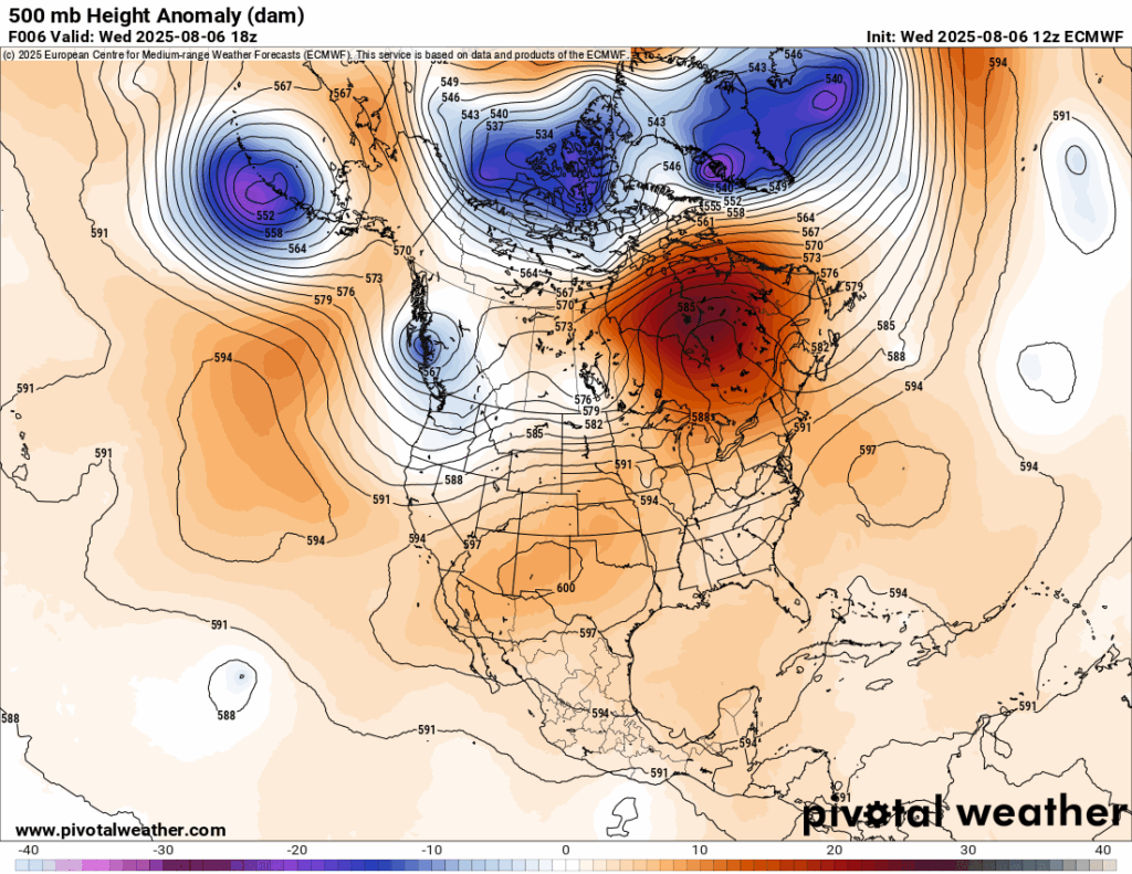
Anytime a heat dome at or above 600 decameters appears above the U.S. and persists for more than a day there will be record heat with monthly and even all-time records in jeopardy. Significant wildfires can explode, also. Pemex, named for Mexico’s nationalized oil company, is no different.
For more details on Pemex here is a new Washington Post article:
https://www.washingtonpost.com/weather/2025/08/06/record-heat-southwest-phoenix
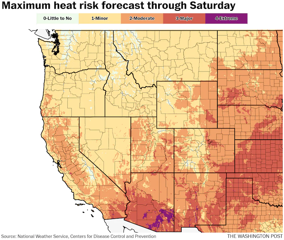
Maps show where record heat will hit the Southwest this week
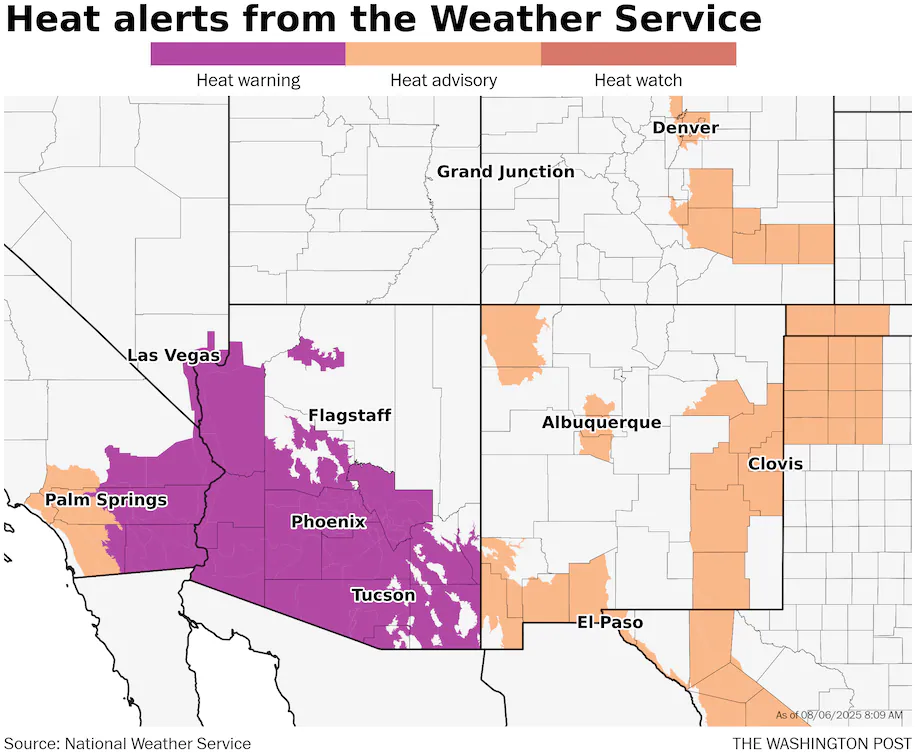
Extreme heat warnings cover most of the southern half of Arizona and continue into southeastern California. Areas including Phoenix, Tucson, Palm Springs and the Grand Canyon are all under this highest level of heat alert. In some of these places, temperatures won’t fall below 90 at night, increasing the risk to population with the lack of any cooler moments.
August 6, 2025

Record temperatures are expected in the Southwest U.S. as a heat dome of high pressure is targeting the region Wednesday and through the rest of the week. Temperatures as high as 120 degrees or higher are expected, amid numerous anticipated record highs and warm lows.
Extreme heat warnings cover most of the southern half of Arizona and continue into southeastern California. Areas including Phoenix, Tucson, Palm Springs and the Grand Canyon are all under this highest level of heat alert. In some of these places, temperatures won’t fall below 90 degrees at night, increasing the risk of severe heat effects on people there.
Heat advisories will stretch west toward the Los Angeles region, stopping just shy of the coastal zone, where some marine influence helps cool the air. Other cities, such as Denver, Albuquerque and El Paso, are under heat advisory on Wednesday and typically through Thursday.
Suburbs around Phoenix, such as Tempe and Sierra Vista, are forecast to suffer Level 4 out of 4 heat risk — where illness is common among the general population and services are impacted — both Wednesday and Thursday. Cities including Phoenix, Denver, Albuquerque, and Amarillo, Texas, are among those forecast to experience Level 3 out of 4 risk, which also brings an increased threat of heat illness.
The worst of the heat is expected over the next day or two in many spots. Any relief thereafter is slow — and any extreme heat is also expected to exacerbate conditions for ongoing wildfires across the western U.S.
What to know about the heat dome
The heat dome is particularly strong — often characterized by “heights” at 500 millibars (about 18,000 feet above the ground), this event is pushing 600 decameters on Wednesday, or the top of the scale on the image below.
Only the most intense heat domes during the peak of summer approach or surpass this level. Such intensity is more typical in the western or central U.S. compared to further east.
While the heat dome may peak through Thursday, impacts of the highest temperatures will persist into the weekend.
The peak of the heat
In Phoenix, the high this year so far is 118 degrees, reached on July 9. Forecasts for Wednesday and Thursday are right around 117, which would both be records for the dates.
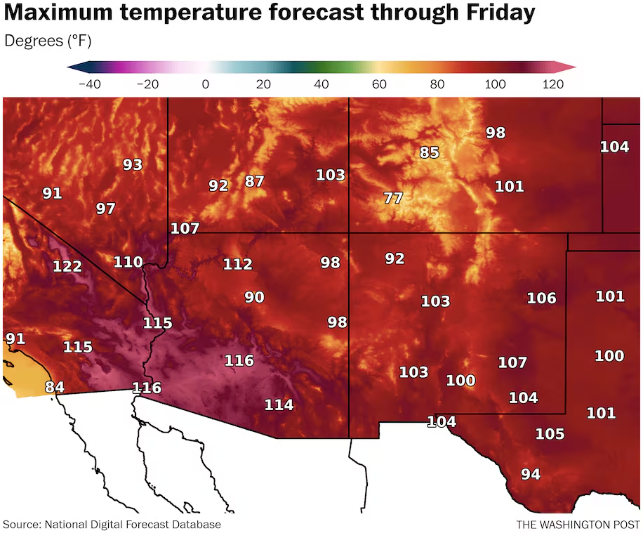
Other locations may also test high temperatures of the year, like Denver. The high there this summer is 100 degrees, also reached in early July. The forecast the next two days in the area is upper 90s to around the century mark.
Highs at or above 100 degrees are forecast for much of Southern California east of the Los Angeles area mountains, then into a big chunk of Arizona, most of lower-elevation southern New Mexico and then out into the plains of Texas, Oklahoma and Kansas.
These temperatures are about 10 degrees above average in many locations, and as high as 15 degrees or more above average in parts of the high Plains.
The overall hottest temperature of the year in the Lower 48 — 124 in Death Valley — may also be threatened in this stretch. That’s most likely to occur on Wednesday or Thursday. The highest forecast temperature in California is currently 125 degrees on Thursday around the Salton Sea to the southeast of Palm Springs.
Drought and lack of moisture feeding the heat — and the flames
For the Southwest, it’s late in the season to be seeing the highest temperatures of the year, should they happen.
By August, the monsoon — a seasonal shift in winds bringing moisture and thunderstorms to the region — increases humidity relative to earlier in the season and produces more cloud cover. Even without copious rainfall, that combination tends to stifle temperature rises compared to earlier in the summer.
But the 2025 monsoon is rather meager to date in much of the Western U.S., with zero to 50 percent of normal precipitation common alongside growing drought. A handful of areas, such as portions of central Arizona and then especially eastward toward eastern New Mexico, have seen above-average precipitation.
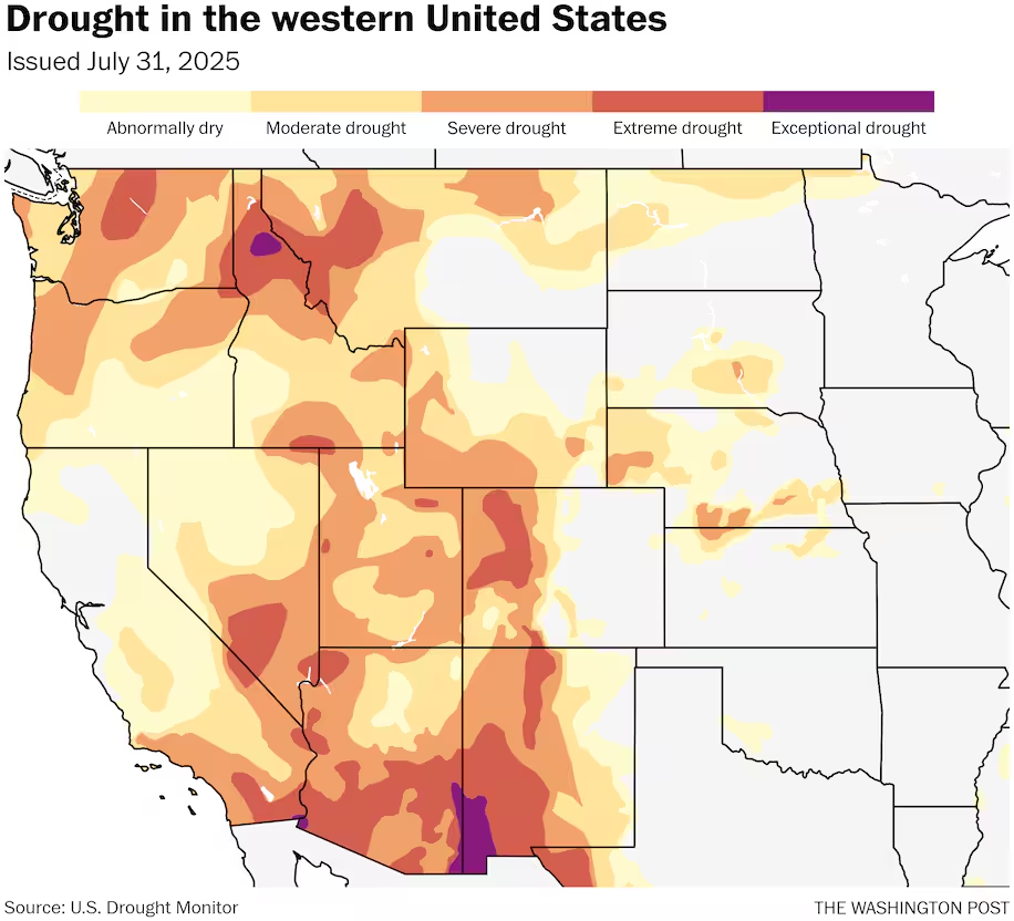
Drought conditions enhance heat potential, which then further dries the land in a feedback loop that can be difficult to break until the cool season arrives or even beyond.
The mix of high temperatures and drought is also fueling a number of large fires in the region, while making them more difficult to fight. The National Interagency Fire Center raised the national preparedness level to 4 out of 5 on Tuesday, largely in response to the worsening threat in the West.
Large blazes have now burned more than 1 million acres in the U.S., including an ongoing 125,000-plus acre conflagration near the Grand Canyon, where temperatures could be around 110 degrees the next few days.
Red flag warnings for fire weather concerns cover much of Utah, Colorado and Wyoming, plus portions of surrounding states, on the north end of the heat dome where winds will be stronger than further south.
What next?
Temperatures should moderate somewhat by the weekend as the heat dome relaxes after reaching peak strength.
While readings are expected to remain near or above normal in the Southwest into next week, by later next week, odds favor temperatures returning closer to typical, which is still of course rather hot
By Ian Livingston Ian Livingston is a forecaster/photographer and information lead for the Capital Weather Gang. By day, Ian is a defense and national security researcher at a D.C. think tank.
Here are more “ET’s” recorded from around the planet the last couple of days, their consequences, and some extreme temperature outlooks, as well as any extreme precipitation reports:
Here is More Climate News from Wednesday:
(As usual, this will be a fluid post in which more information gets added during the day as it crosses my radar, crediting all who have put it on-line. Items will be archived on this site for posterity. In most instances click on the pictures of each tweet to see each article. The most noteworthy items will be listed first.)