The main purpose of this ongoing blog will be to track planetary extreme, or record temperatures related to climate change. Any reports I see of ETs will be listed below the main topic of the day. I’ll refer to extreme or record temperatures as ETs (not extraterrestrials).😜
Main Topic: Looking Back at Hurricane Katrina
Dear Diary. Today is the 20th anniversary of Hurricane Katrina roaring ashore into Louisiana and Mississippi, producing thousands of deaths and billions of dollars in damages. Katrina made many people realize that climate change was a problem because science indicated that it was strengthened by warmer than average Gulf waters. Today the Atlantic basin is warmer than in 2005, so many more Katrina type storms will affect the U.S. going through this century, unfortunately.
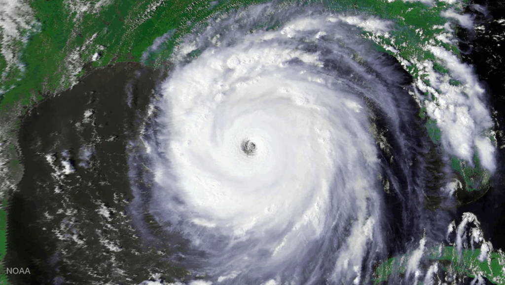
In the week leading up to this tragedy, I helped forecast Katrina as it strengthened along its westward track across the Gulf at the Weather Channel, almost not believing data coming from the National Hurricane Center via hurricane hunter dropsondes. At its peak CAT 5 Katrina had an extremely low pressure of 902 millibars and was immense by hurricane size standards. My associates were also aghast at what they were seeing on satellite loops knowing full well what would happen to a large area along the central Gulf Coast at landfall.
Dr. Jeff Masters has written an excellent new article on his experiences forecasting Katrina, which I am sharing today:
‘Evacuate NOW!’: What it was like to sound the alarm ahead of Hurricane Katrina
It was my first season of hurricane blogging, and I had an uneasy feeling about a tropical storm moving toward the Gulf.

by Jeff Masters August 28, 2025

Category 5 Hurricane Katrina on August 28, 2005, as seen from NOAA’s AVHRR instrument.
I first started blogging for Weather Underground, the weather service I founded, in the spring of 2005. For the first few months, it was a slow time for interesting weather events, and I had trouble finding topics to write about. I was relieved when June 2005 brought two Atlantic tropical storms to discuss.
But as July brought an unprecedented five named storms, three hurricanes, and two major hurricanes that were the strongest hurricanes ever recorded so early in the season, I was ready for less to write about. The peak of hurricane season was still a month away.
I managed to take advantage of a slight break in the action in mid-August to travel for vacation and business, and the day Katrina was named — August 24 — I was in New York City, attending meetings with the Associated Press, which had just signed up to use Weather Underground as the weather provider for their 5,000 newspapers.
I wasn’t able to follow the storm closely that day because of the meetings. Still, I had an uneasy feeling about this new storm named Katrina. When one of the AP staff members remarked, “It sure has been a slow summer for news. We need a big story,” I looked at her hard and thought, “Be careful what you wish for — you might get it!”
I flew home on Thursday, August 25, when Katrina was an intensifying tropical storm headed for South Florida. The next morning, I decided to drive north with my family to spend a four-day weekend at my father’s house. High-speed Internet was not available in his small town of Topinabee, Michigan, on beautiful Mullet Lake, so I knew I’d be spending some hours blogging on his slow 9,600-baud dial-up connection.
Still, I figured Katrina would quickly recurve to the north and hit the Florida Panhandle before it had a chance to become a major hurricane, like the National Hurricane Center was predicting that morning.

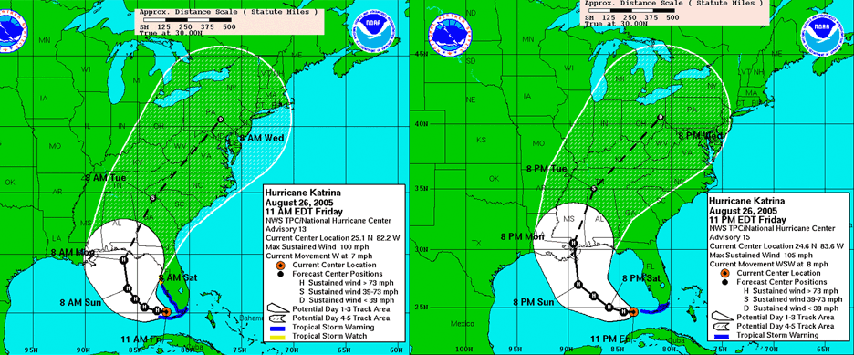
Figure 1. Forecasts issued 12 hours apart on August 26, 2005, by the National Hurricane Center showed a massive 200-mile shift to the west. (Image credit: NHC)
Wrong. The NHC forecast that evening made a dramatic 200-mile shift to the west, putting landfall perilously close to New Orleans. I spent virtually the entire weekend holed up upstairs in the computer room, writing increasingly worried and strident blog posts exhorting people in New Orleans and Mississippi to evacuate. Every now and then, I’d emerge downstairs and say hi to everyone, then head back up to my cell to watch slowly loading pages and write new posts. Finally, I couldn’t take it anymore and talked my family into returning home a day early, on Sunday, August 28, the day before Katrina made landfall in Mississippi.
Here’s my entry on Jeff Masters’ Wunderblog posted at 10 a.m. EDT Saturday, August 27, two days before landfall:
I’d hate to be an Emergency Management official in New Orleans right now. Katrina is pretty much following the NHC forecast, and appears likely to pass VERY close to New Orleans. I’m surprised they haven’t ordered an evacuation of the city yet. While the odds of a catastrophic hit that would completely flood the city of New Orleans are probably 10%, that is way too high in my opinion to justify leaving the people in the city. If I lived in the city, I would evacuate NOW! There is a very good reason that the coroner’s office in New Orleans keeps 10,000 body bags on hand. The risks are too great from this storm, and a weekend away from the city would be nice anyway, right? GO! New Orleans needs a full 72 hours to evacuate, and landfall is already less than 72 hours away. Get out now and beat the rush. You’re not going to have to go to work or school on Monday anyway. If an evacuation is ordered, not everyone who wants to get out may be able to do so–particularly the 60,000 poor people with no cars.
In the months that followed, it was gratifying to hear from a number of blog readers who had heeded my advice and gotten out of the city before Katrina hit. Fellow meteorologist Steve Gregory, who also blogged at Weather Underground about the impending catastrophe, had a similar experience. Sounding the alarm was the right call! Now if only my posts on climate change would evoke a similar response …
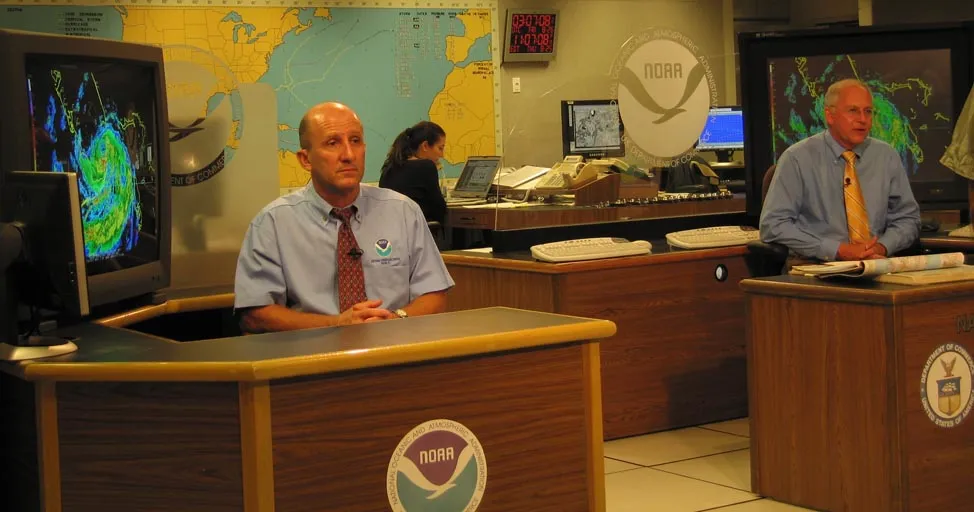
My Weather Underground and Yale Climate Connections colleague Bob Henson was at the National Hurricane Center when Katrina moved over the Miami area on August 25 as a Category 1 hurricane. Bob recalls: ‘Through the hardened windows of the NHC building, I could see sheets of rain moving almost sideways in the fierce wind. We stepped outside briefly during the eye, when the skies were still mostly cloudy but the wind went calm for a few moments. Lightning flickered around the horizon. It was the first time that NHC director Max Mayfield and hurricane specialist Lixion Avila – and myself – had experienced the eye of a hurricane.”

Figure 2. Hurricane specialist Lixion Avila (left) and NHC director Max Mayfield (right) at the National Hurricane Center on August 25, 2005, during Hurricane Katrina. (Image credit: Bob Henson)
Coming soon: a follow-up post marking the 20th anniversary of Katrina titled, “What happens when the next big hurricane hits New Orleans?”
Bob Henson contributed to this post.
MORE LIKE THIS

What happens to New Orleans’ levees when a Category 4 hurricane hits?

‘Deadliest in generations’: The Texas floods are the latest in a disturbing pattern

After Fernand, a quiet spell on tap for the Atlantic

Jeff Masters
Jeff Masters, Ph.D., worked as a hurricane scientist with the NOAA Hurricane Hunters from 1986-1990. After a near-fatal flight into category 5 Hurricane Hugo, he left the Hurricane Hunters to pursue a… More by Jeff Masters
Jeff Master’s and Bob Henson’s “Evacuate NOW!’: What it Was Like to Sound the Alarm Ahead of Hurricane Katrina” was first published on Yale Climate Connections, a program of the Yale School of the Environment, available at: http://yaleclimateconnections.org. This work is licensed under a Creative Commons Attribution-Noncommercial-No Derivative Works 2.5 license (CC BY-NC-ND 2.5).
More:
Here are more “ETs” recorded from around the planet the last couple of days, their consequences, and some extreme temperature outlooks, as well as any extreme precipitation reports:
Here is More Climate News from Friday:
(As usual, this will be a fluid post in which more information gets added during the day as it crosses my radar, crediting all who have put it on-line. Items will be archived on this site for posterity. In most instances click on the pictures of each tweet to see each article. The most noteworthy items will be listed first.)