The main purpose of this ongoing blog will be to track planetary extreme, or record temperatures related to climate change. Any reports I see of ETs will be listed below the main topic of the day. I’ll refer to extreme or record temperatures as ETs (not extraterrestrials).😜
Main Topic: Eye Opening October Heat Records Broken Across Australia
Dear Diary. While typical fall weather was settling into the United States, spring became very much like summer across eastern Australia. So much so that the heat wave there became historic. It’s no wonder looking at the heat dome that built across the region earlier this week:
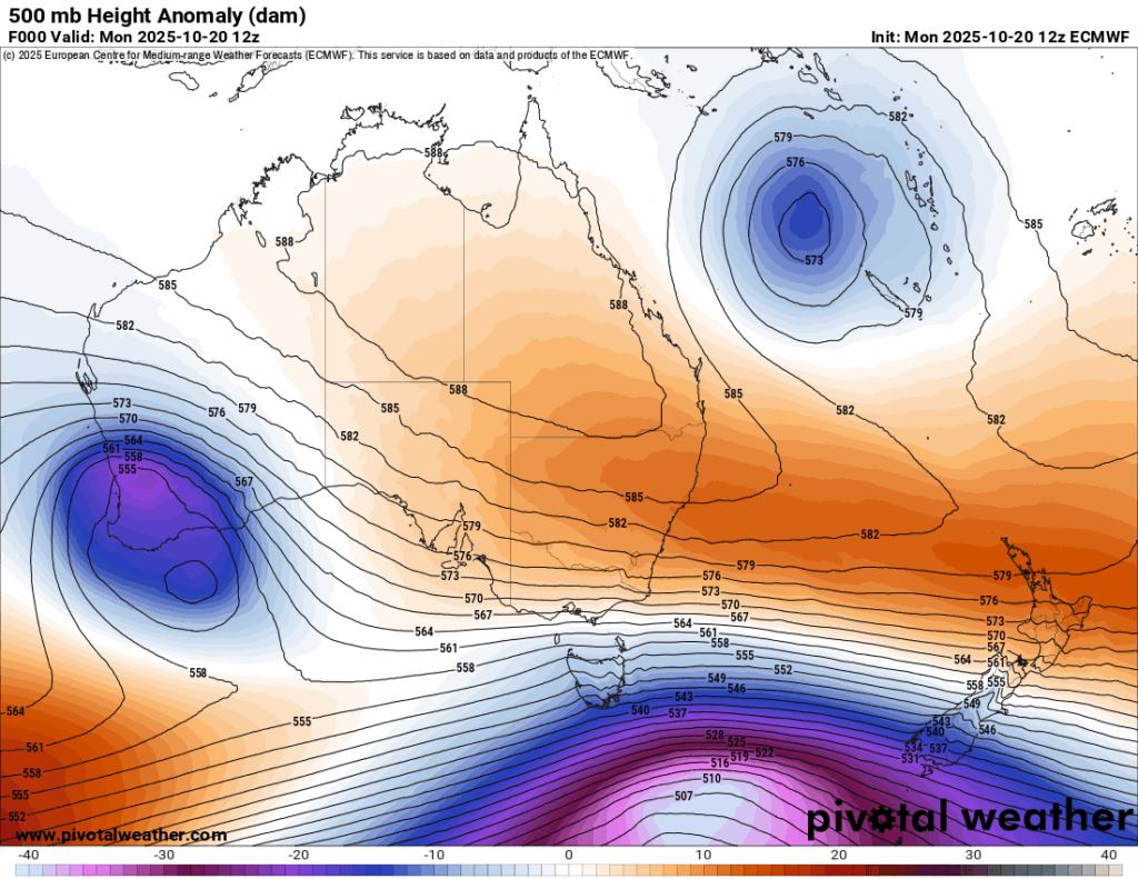
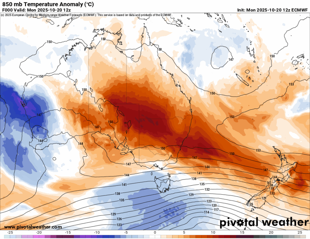
The last several days weather historian Maximiliano Herrera has been logging astounding records coming from the Australian region. Here are most of his notes:
Here are more details from the Guardian:
Australian climate and environment in focusAustralia weather
October heat records broken across Australia as Sydney braces for temperatures way above the norm
Birdsville sets new high as BoM forecasts more record hot weather, with heatwave warnings in place in some states
- Follow our Australia news live blog for latest updates
- Get our breaking news email, free app or daily news podcast
Hot, dry and windy weather means high fire danger is expected across most of Queensland and NSW for Wednesday as parts of Australia endure record heat. Photograph: Australian Associated Press/Alamy
Tue 21 Oct 2025
October heat records have been broken in several states this week as authorities in New South Wales prepare for temperatures above the norm to hit Sydney and the east coast of Australia.
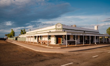
The Queensland outback town of Birdsville broke a new record on Tuesday, hitting 46.1C at 2.28pm local time, according to the Bureau of Meteorology, making it the highest temperature recorded in the state in October. The state’s previous October record was 45.1C at Birdsville police station on 31 October 1995.
NSW also recorded its highest ever October temperature, with Bourke airport reaching 44.8C at 4pm local time on Tuesday. The previous NSW record for the month was 43.9C at Brewarrina on 31 October 1919.
The BoM on Tuesday forecast a Wednesday high of 38C for Sydney’s central business district. If temperatures inch beyond that, the city’s October heat record of 38.2C, set in 2004 at Observatory Hill, could fall.
Temperatures in some western suburbs of Sydney were expected to reach 40C, according to the BoM.
New October heat records have been set across towns and cities in Western Australia, Queensland, South Australia and NSW on Sunday and Monday, with more expected.
“The temperatures we’re seeing today are just way above the norm,” said BoM senior meteorologist Angus Hines, with maximums up to 16C above average for parts of NSW, SA and Queensland.
Other new October records in Queensland included Windorah (43.2C) and Thargomindah (43.1C). Moomba, in north-east SA, reached 44.1C. In NSW, record highs were observed at Tibooburra (42.6C), Cobar (40.1C), Penrith Lakes in western Sydney (39C), and Gosford on the Central Coast (36.9C).
“Alongside these very hot days, there are stifling nights as well, causing heatwaves to trigger in some areas,” Hines said, with heatwave warnings in place for parts of WA, the Northern Territory, northern SA, Queensland and NSW.
Cooler temperatures, with windy and stormy conditions, were expected for Victoria, southern SA and Tasmania as a cold front passes through.
The bureau has issued severe weather warnings for damaging winds on Wednesday, covering much of the NSW south-east, south-east SA, and most of Victoria.
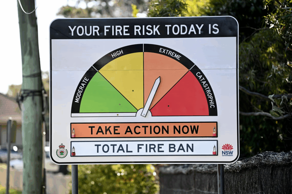
Hot, dry and windy weather means high fire danger is expected across most of Queensland and NSW for Wednesday, with extreme conditions forecast, and total fire bans declared in the following council areas: greater Sydney, greater Hunter, Illawarra and Shoalhaven, the Upper Central West Plains and North Western.
Inspector James Morris, a spokesperson for the NSW Rural Fire Service, said 32 bushfires and grassfires were burning across the state on Tuesday, with 11 still to be contained.
“We’re likely to see very hot temperatures, very windy conditions and very low humidity – very dry across most parts. That combined with increased fuel loads – that’s the biggest risk for tomorrow,” he said.
A spokesperson for Fire and Rescue NSW said the agency was working closely with the RFS and other emergency partners to coordinate efforts across the state.
“Conditions mean fires can start easily and spread rapidly, so we’re asking the community to remain vigilant and prepared,” the spokesperson said.
Firefighting resources have been positioned in high-risk areas, with additional crews on standby and firefighting aircraft and specialist teams ready to respond at short notice.
“We’re asking everyone to take the time now to prepare,” Fire and Rescue NSW’s spokesperson said.
“Clear leaves and debris from gutters and yards, move flammable materials away from your home, and check that hoses and pumps are working. Know your plan – if you live in a bushfire-prone area, understand your trigger points for leaving early.”
Australia’s energy market operator, Aemo, said there was sufficient electricity supply to meet forecast demand in NSW and it had a “variety of levers” available to ensure there were sufficient reserves in place.
A spokesperson for the wildlife information and rescue service Wires said extreme heat could significantly affect all animals, potentially leading to dehydration, exhaustion and even death.
People could leave out shallow bowls of water for wildlife and contact rescue organisations if they saw animals showing signs of heat stress, the spokesperson said. Pets should be kept inside where possible.
The heat was expected to ease for much of the east coast and SA by the end of the week, Hines said, except in Queensland where “above average temperatures will continue” into the weekend “and even into next week with no relief in sight”.
Australia’s national annual average temperature is about 1.5C higher than in 1910, according to the BoM, and the climate crisis has increased the frequency and severity of extreme weather events.
Here are more “ETs” recorded from around the planet the last couple of days, their consequences, and some extreme temperature outlooks, as well as any extreme precipitation reports:
Here is More Climate News from Thursday:
(As usual, this will be a fluid post in which more information gets added during the day as it crosses my radar, crediting all who have put it on-line. Items will be archived on this site for posterity. In most instances click on the pictures of each tweet to see each article. The most noteworthy items will be listed first.)