The main purpose of this ongoing blog will be to track planetary extreme, or record temperatures related to climate change. Any reports I see of ETs will be listed below the main topic of the day. I’ll refer to extreme or record temperatures as ETs (not extraterrestrials).😜
Main Topic: Record Cold Outbreak Slated for Eastern U.S.
Dear Diary. It’s interesting that our climate changing atmosphere is at a state such that significant record cold outbreaks can only be expected about once every eleven months as of 2025. This statistic can roughly be shown using my record scoreboard shown here:
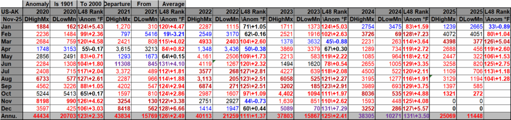
DHMX= Daily High Max Reports. DLMN= Daily Low Min Reports. DHMN= Daily High Min Reports. DLMX=Daily Low Max Reports.
Boldly highlighted red, blue, or purple colored months, such as December 2023 and June 2021, that have ratios of >10 to 1 daily or <1 to 10 of daily warm to low records are either historically hot or cold, most of which have made news. NCEI rankings are for the lower 48 states with the warmest ranking since 1895 of average temperatures being 131 and 1 being the coldest as of 2025. Blue colors represent cold months and red warm. Those months and years with counts close to a 1 to 1 ratio of highs to lows are colored black. All-time record hottest or coldest months and years are boldly colored in purple. NCDC rankings have been color coded (under tabs in each file) such that values of 55 to 75 are black representing neutral months or years (+ or – 10 from the average ranking of 64).
Looking at the above chart since the start of 2023, cold months have been occurring about once a year, and since the last one occurred in January 2025, we are due for another. So far in November there have been numerous heat records, so the cold outbreak slated for early next week may not produce a colder than average month for the continental U.S., but we will see.
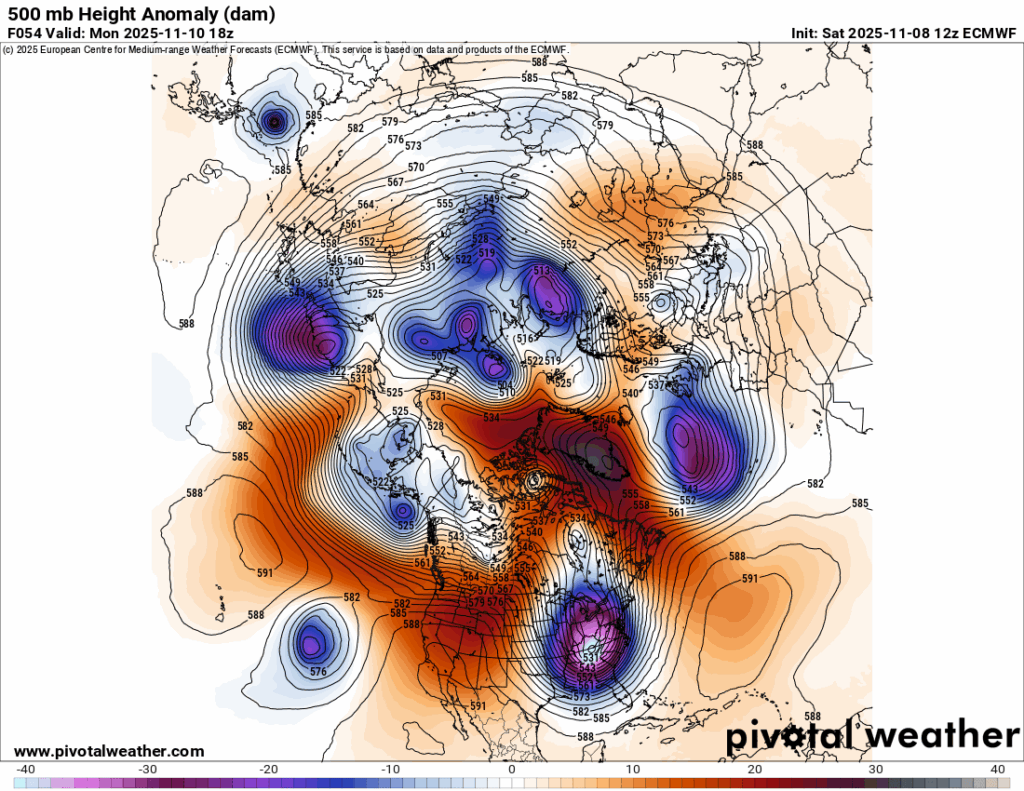
The 500 millibar pattern across the Northern Hemisphere by Tuesday looks exceptionally warm except in one place, the eastern U.S.:
Check out the work by Dr. Jennifer Francis on polar amplification in association with climate change to learn more about why Arctic outbreaks are still possible in our warming world.
Here are more details from the Washington Post:
Cold records dating back to the 1800s may be broken by a coming Arctic freeze
The first freezing, Arctic outbreak of the season is headed for the United States this weekend into next week. Some states will see their first snowfall.
Updated November 7, 2025 at 7:53 a.m.

A D.C. winter scene in December 2020. (Jonathan Newton/The Washington Post)
By Ben Noll and Matthew Cappucci
The season’s first outbreak of freezing, Arctic air is headed for the United States this weekend into next week. It will register as the most unusually cold blob of air on the planet for a time.
Chilly air will reach the Plains and the Midwest this weekend before spreading to the East Coast on Monday. In total, 155 million people across the contiguous states are expected to experience freezing conditions through Wednesday.
The most notable aspect of this early-season blast of cold air is how far south it will push, reaching the Deep South, the Gulf Coast and Florida, where temperatures will tumble 20 to 30 degrees below average for the time of year early next week. In the Sunshine State, the frigid air may break low-temperature records and cause iguanas to fall from trees. The air will also be remarkably dry, making it feel even colder when combined with gusty winds.
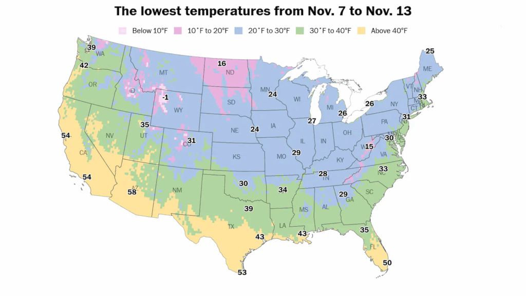
About 155 million people across the United States are forecast to experience freezing temperatures through early next week. (Ben Noll/The Washington Post/Data source: ECMWF)
Across parts of Michigan, possibly including Detroit, the arrival of the cold wave may be marked by a period of snow early Sunday — the first of the season. From Sunday into Monday, snow showers and squalls could stretch from the Upper Midwest to the southern Appalachians, with flurries possibly reaching the Mid-Atlantic on Monday night.
The cold air will also spark the development of lake-effect snow bands. The contrast between near-record warm Great Lakes water temperatures and the unusually cold air mass above will be substantial, contributing to more atmospheric instability and the potential for locally heavy snow bands in Michigan, Ohio, Pennsylvania and New York from Monday to Wednesday.
Where temperature records might be broken
New temperature records — record cold days or nights — might be set across 13 states, from Pennsylvania to Florida, into next week.
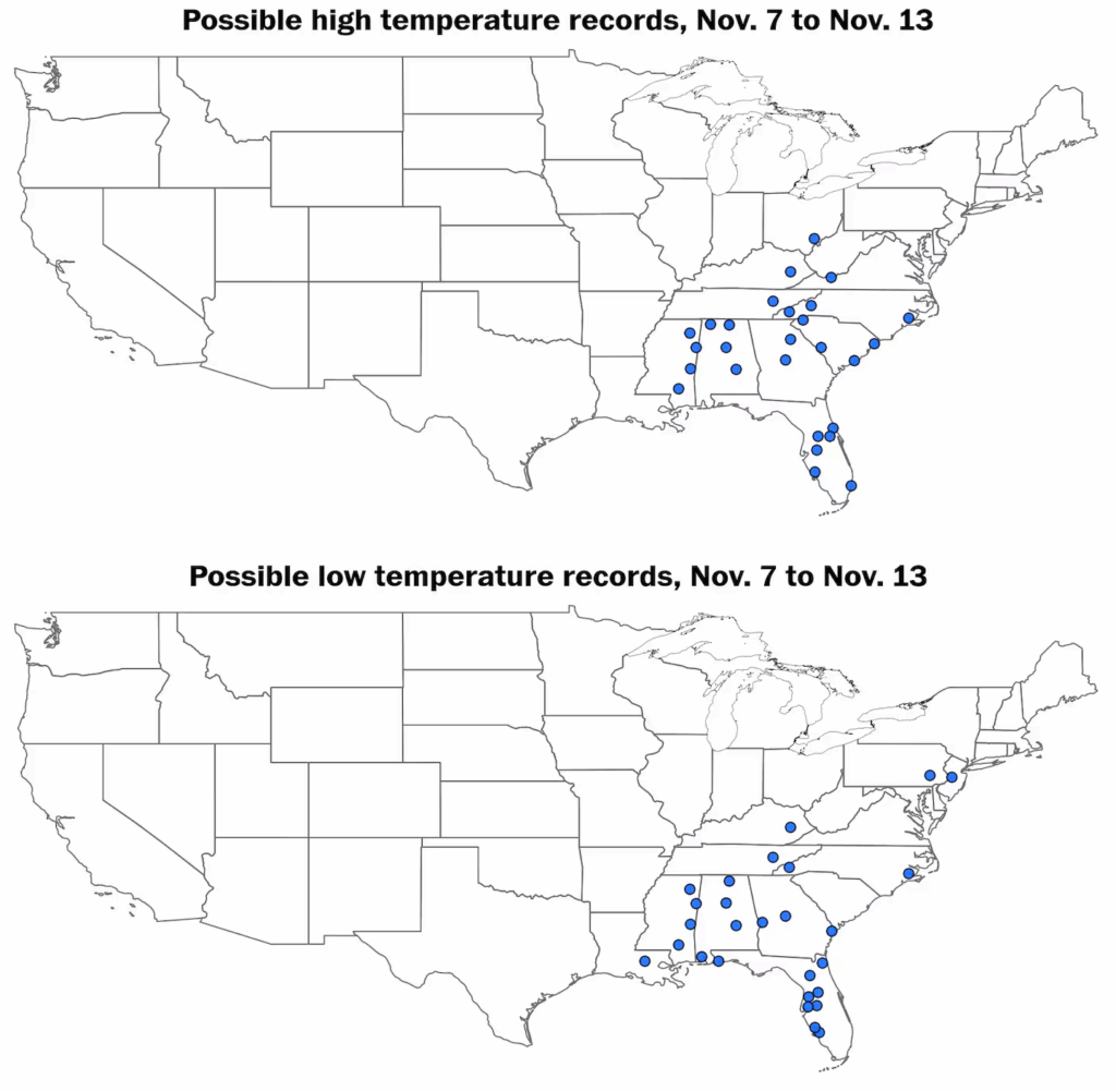
Thirteen states may experience record low daytime high temperatures (top) and/or record low overnight low temperatures (bottom) over the next week. (Ben Noll/The Washington Post/Data source: NOAA)
The first records are expected Monday, when much of the Deep South will struggle to climb out of the 40s. Across the Cumberland Plateau of Tennessee, highs will remain stuck in the 30s. Knoxville’s forecast afternoon high is only 37 degrees, which would be a record for the chilliest afternoon high temperature; the previous record of 41 was set in 1973. Records date back to 1947.
In Huntsville, Alabama, the high on Monday afternoon is projected to be 42 degrees, falling below the previous record of 43 set in 1950. There, records date back to 1907.
In Birmingham, Alabama, temperatures are also projected to see a record cold afternoon maximum temperature of just 46 degrees. The average for early to mid-November is 66 degrees, meaning the Deep South will be running about 20 degrees below average.
The city of Meridian in Mississippi is set to see a record chilly high temperature of 48 degrees, and records there extend back to 1889. Meanwhile, Tallahassee’s records also go back to the late 1800s, and its record is in jeopardy — Monday should hit a high of only 54 degrees.
The polar plunge firmly takes hold Monday night, when most of Tennessee, Mississippi, Alabama and Georgia will fall into the 20s — Birmingham and Huntsville should achieve record lows of 25 and 22 degrees respectively; Macon, Georgia, will come close to a record of 27 degrees. And even Savannah, Georgia — where records date back to 1874 — should tie a record of 31 degrees.
In northern and central Florida, temperatures are forecast to drop into the lower and middle 30s on Tuesday morning, as local meteorologists warn of falling iguanas. Jacksonville should set a record at 34 degrees. Lakeland International Airport is projected to dip to 38, far below the record of 44 degrees.
The frigid air may immobilize the cold-blooded iguanas, causing them to fall from trees. In Brooksville, Florida, north of Tampa, a predicted low temperature around 34 will threaten a record from 1894. If it dips into the 30s in Orlando, it will be the earliest such occurrence since 1993. High temperatures on Tuesday will reach only the 50s and 60s across the state, again threatening records.
On Monday, a predicted high temperature of 49 degrees in Montgomery, Alabama, could challenge a record from 1892. The average high this time of year is in the lower 70s.
By Tuesday afternoon, most of the central and northern Florida Peninsula will climb into only the lower- to mid-60s, flirting with records for the chilliest afternoon maximums recorded.
Where snow could fall
Swaths of accumulating snow are likely from the Dakotas to Maine, southward into the Ohio Valley and the Appalachians, as well as around the Great Lakes from Saturday to Wednesday.
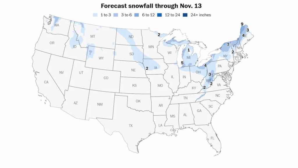
Several inches of snow may fall across the Midwest, Appalachians and Northeast into early next week as the Arctic blast arrives. (Ben Noll/The Washington Post/Data source: ECMWF)
As cold air blows over warm waters and picks up moisture, lake-effect snow streamers may aim at the lakeshores. On Sunday night and Monday, this could include western parts of Michigan’s Lower Peninsula; by Monday evening, the typically vulnerable Lakes Erie and Ontario snowbelts will become involved, including around northern New York’s Tug Hill Plateau, where more than a foot is possible.
A secondary Sunday night clipper system could also drop accumulating snow in the higher elevations of interior New England as moisture falls beneath the frigid upper-level low.
People from Chicago to Indianapolis and Louisville may awaken to a covering of snow on Monday morning — and freezing temperatures could make for slick roads.
Additional snows are possible Wednesday as a secondary system pivots through.
A sign of things to come this winter?

A blast of Arctic air will reach central and eastern states this weekend into next week, marked by well below-average temperatures. (Ben Noll/The Washington Post/Data source: ECWMF/ERA5)
The cause of the short-but-sharp cold pattern is a loopy polar jet stream, guiding icy air southward from northern Canada — channeled toward the United States because of a stagnant area of unusually warm, high pressure near Greenland.
During La Niña, the polar jet stream tends to be more active than normal, increasing the risk for fast-moving outbreaks of cold air and snow across northern states.
Meanwhile, southern states tend to have milder and drier weather because of a weaker subtropical jet stream, leading to more tranquil conditions.
Despite this widespread and notable early polar plunge, milder air is forecast to return to central and eastern states during the second half of the month.
Here are more “ET’s” recorded from around the planet the last couple of days, their consequences, and some extreme temperature outlooks, as well as any extreme precipitation reports
Here is More Climate News from Saturday:
(As usual, this will be a fluid post in which more information gets added during the day as it crosses my radar, crediting all who have put it on-line. Items will be archived on this site for posterity. In most instances click on the pictures of each tweet to see each article. The most noteworthy items will be listed first.)