The main purpose of this blog will be to track planetary extreme, or record temperatures related to climate change. Any reports I see of ETs will be listed below the main topic of the day. I’ll refer to extreme or record temperatures as ETs (not extraterrestrials).😜
Main Topic: Christmas 2025 is Forecast to Become the Warmest One on Record Across the United States.
Dear Diary. A week ago, it became obvious that the lower 48 states would have a very warm Christmas, but we didn’t know how warm:
Today according to Washington Post statisticians, it looks like Christmas 2025 will be the warmest Christmas on record for the lower 48 states. Not only that, but a whole week running from December 22nd through December 28th will be super warm. In my neck of the woods in Atlanta people will be in shorts during the afternoon as temperatures climb into the mid 70s from Christmas Eve through the weekend after Christmas, for example.
Here are many more details from the Washington Post (For a chart that I did not include plus tables of potential records, hit the following link):
Where we’ll see record warmth this Christmas – The Washington Post
Where we’ll see record warmth this Christmas
Christmas 2025 is forecast to become the warmest one on record across the United States.
December 23, 2025 at 6:09 a.m. EST
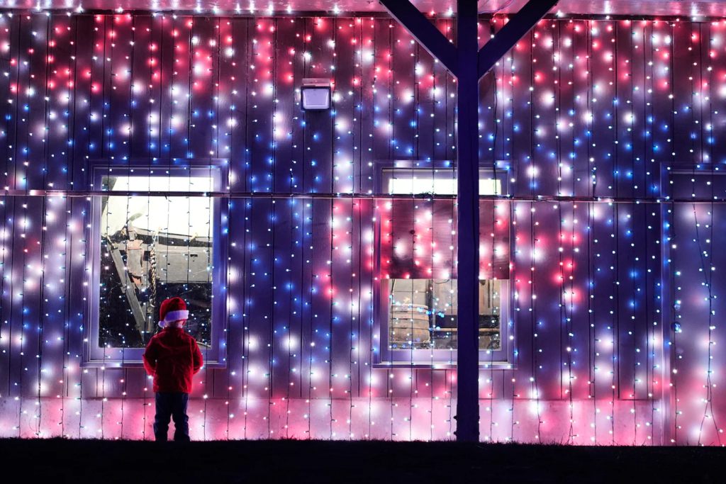
Christmas lights in Lenexa, Kansas. (Charlie Riedel/AP)

By Ben Noll
This Christmas is forecast to become the warmest one on record across the United States.
A predicted average high temperature of 53.9 degrees across the contiguous states would make it the warmest Dec. 25 by a wide margin, surpassing the previous record of 49 degrees in 2005. A nationwide average minimum temperature of 39.7 degrees on Christmas morning is also forecast to be the highest on record. While temperatures on one day of the year aren’t a reliable indicator of climate change, winter temperatures are rising countrywide, especially in the Northeast.
On Christmas Day, more than 100 individual high temperature records are forecast to be neared, tied or broken across parts of 23 western and central states — from California to Indiana — as Santa rides into some towns wearing shorts and a T-shirt. Temperatures are forecast to be 15 to 35 degrees above average across this stretch.
Temperatures this month so far have been below average across most central and eastern states due to an unusually early disruption to the polar vortex, which also drove a snowy start to the season.
But the weather pattern is now taking a rapid turn, as subtropical air from atmospheric rivers hitting California blows across the country.
Many records will be broken
More than 450 temperature records, by day and night, are forecast to be neared, tied or broken across 30 states from Dec. 23 to Dec. 29 — with most of these occurring on Christmas Day.
More than 100 temperature records may be neared, tied or broken across the United States on Christmas. (Ben Noll/Data source: ECMWF/ERA5)
Texas is forecast to have the country’s hottest conditions on Christmas, when it will reach the upper 80s. Cities there such as Childress (84 degrees), Abilene (82 degrees), Wichita Falls (81 degrees), and Dallas and Lubbock (80 degrees) are forecast to near, tie or break high temperature records.
Elsewhere, a forecast high of 78 degrees in Tulsa and 77 in Oklahoma City on Christmas would shatter the previous record of 73 in both cities. A record-breaking Christmas low temperature of 61 degrees in Tulsa would be more than 10 degrees higher than the average high temperature this time of the year.
In Missouri, Kansas City is forecast to reach a record-breaking 70 degrees, a temperature more typical of early October. Also near their respective Christmas records of 75 degrees and 69 degrees will be Atlanta and Denver.
In Arizona, the cities of Phoenix (61 degrees) and Yuma (61 degrees) as well as Las Vegas in Nevada (53 degrees) are forecast to experience record high minimum temperatures on Christmas morning.
In other places, the holiday will be more typical. No statewide Christmas temperature records are forecast in Alaska or Hawaii this year. In Alaska, the average high on Thursday is forecast to be a seasonably frigid 10.8 degrees. In Hawaii, it’s forecast to be a balmy 71.4 degrees.
Some will have a white Christmas
The Northeast won’t have record warmth. Instead, this corner of the country will be one of the few to have a white Christmas.
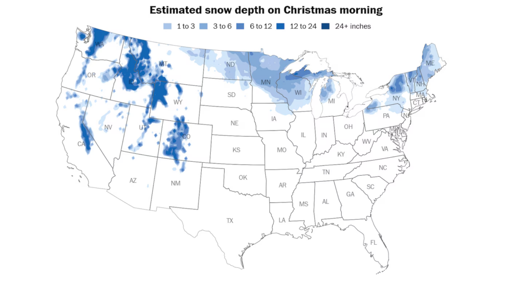
A relatively small fraction of the United States can expect a white Christmas this year, totaling around 15 to 20 million people across the country. (Ben Noll/Data source: ECMWF)
A system crossing the region from Tuesday into Wednesday will bring a swath of 1 to 3 or 3 to 6 inches of snow from northeastern Pennsylvania to New England. Holiday travelers may encounter snow-covered and slippery roads along Interstates 81, 84, 90 and 95 across the region — from Scranton, Pennsylvania, to Binghamton and Albany, New York, to Boston.
Some of this snow will last until Christmas morning, when 15 to 20 million people from the Intermountain West to the Upper Midwest and Northeast will awaken to grounds covered by at least an inch of snow.
Another winter storm is forecast to bring substantial snow and ice to the Northeast from Friday into Saturday.
Why it will be so warm and how long it will last
As atmospheric rivers drench California, they are also transporting warm, humid air from the tropics into the United States. This volatile weather pattern is linked to a big dip in the jet stream near the West Coast and a strong ridge of high pressure anchored over the Gulf of Mexico.
These two features are causing the air to take a looping 4,000-mile path from the tropical Pacific Ocean near Hawaii — a warm and humid place — to Mexico before reaching the Midwest on Christmas.
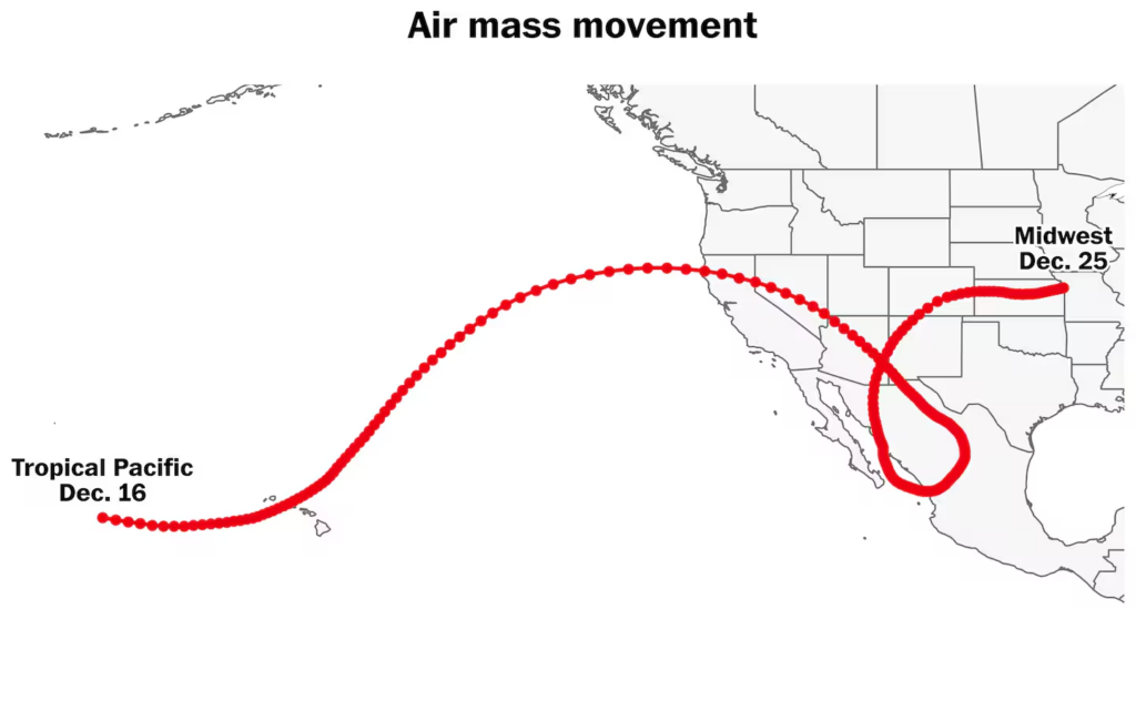
Unseasonably warm air arriving in the Midwest is taking a looping, 4,000-mile path from the tropical Pacific Ocean near Hawaii. (Ben Noll/Data source: NOAA/HYSPLIT)
For many central and some western and eastern states, unseasonably warm conditions will last into the weekend before Arctic air surges southward.
This will send temperatures tumbling to start the week of Dec. 29 into the new year in the Midwest and East.
However, there are signs that the first half of January — typically the coldest time of the year — will again turn warmer than average across much of the country.
More extensive snow shortfalls could develop next month, with some meteorologists expecting the milder pattern to last into February.
By Ben Noll Ben Noll is a meteorologist passionate about explaining the why behind the weather, extreme events and climate trends. He has expertise in data analysis, supercomputer-driven graphics and forecasting weather worldwide. follow on X@BenNollWeather
Here are some “ETs” recorded from around the planet the last couple of days, their consequences, and some extreme temperature outlooks, as well as any extreme precipitation reports:
Here is More Climate News from Tuesday:
(As usual, this will be a fluid post in which more information gets added during the day as it crosses my radar, crediting all who have put it on-line. Items will be archived on this site for posterity. In most instances click on the pictures of each tweet to see each article. The most noteworthy items will be listed first.)