The main purpose of this ongoing blog will be to track global extreme or record temperatures related to climate change. Any reports I see of ETs will be listed below the main topic of the day. I’ll refer to extreme or record temperatures as ETs (not extraterrestrials).😜
Main Topic: As the World Warms, Freezing Rain Shifts to the U.S. South
Dear Diary. The rise of CO2 concentrations in the atmosphere are affecting all traditional “weather zones.” The tornado belt across the Midwest and South is shifting as the climate gets warmer. We are witnessing tornado outbreaks farther to the north as unseasonably warm air occurs during the fall winter and spring. The last two winters the polar vortex has been squeezed southward by warming air in the Arctic bringing historic snowfalls to the Deep South, but otherwise snow is becoming more rare in this area of the country.
Another winter phenomenon that is much more of a hazard and much less desired to fall is freezing rain. Apparently when we do get a synoptic winter storm situation going on across the South, freezing rain is increasing. As the world warms, I suspect that the “freezing rain zone” will shift even further north into the Midwest and Northeast. These systems can cause millions of dollars in damage and leave people shivering without power for days and can cause multiple fatalities on roads.
Here are more details from Science:
As the world warms, freezing rain shifts to the U.S. South | Science | AAAS
As the world warms, freezing rain shifts to the U.S. South
Recent winter storm traced the path of an emerging ice corridor
- 3 Feb 2026
- 3:25 PM ET
- ByHannah Richter
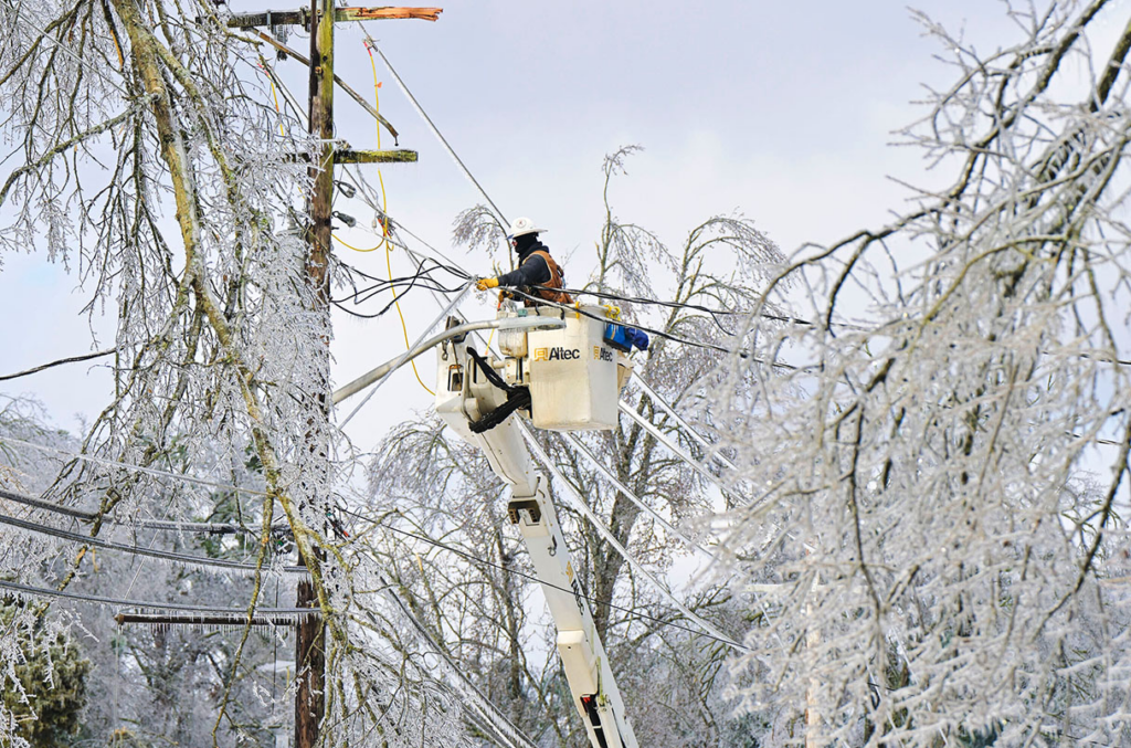
A utility worker restores power in Mississippi, following a January storm that dropped tens of millimeters of freezing rain. Bruce Newman/AP
Over the weekend of 24–25 January, a major winter storm blanketed the eastern United States in soft snow. Then, in many places, the powder gave way to freezing rain, glazing trees and roads in heavy, dangerous ice, bringing down power lines, and depriving 1 million people of light and heat.
Freezing rain is a stealth winter hazard, says Zong-Liang Yang, an earth systems scientist at the University of Texas at Austin. “People are really worried about heat waves, heat domes, and wildfires,” he says. “Compared to those big natural disasters, [freezing rain is] relatively understudied.”
Nevertheless, a handful of scientists are studying how this rare but destructive form of precipitation might be changing in a warming world, drawing on long-term records, new measurements, and computer modeling. One early result: Freezing rain isn’t vanishing—but it is shifting in location and timing. “We want to make an urgent warning that these kinds of winter hazards won’t be less frequent under a warmer climate,” says postdoctoral researcher Chenxi Hu, who works with Yang. Instead, in the U.S., they are occurring later in winter, and moving toward the southeast, Yang said in a presentation in December 2025 at the American Geophysical Union’s (AGU’s) annual meeting.
Freezing rain requires finicky conditions. The air must be layered like a cold-warm-cold sandwich: Precipitation that begins as snow high in the atmosphere melts to rain as it falls, then gets shocked with cold just before landing to freeze on contact as characteristically sticky ice.
Those conditions are highly sensitive to changes in temperature, according to a team at Ouranos, a Quebec-based climate research and consulting organization founded after a major 1998 Canadian ice storm. Using top regional climate models, Dominique Paquin, an atmospheric physicist and climate modeler, and her colleagues simulated more than 3500 years’ worth of the North American atmosphere. They found that temperature changes of less than 1°C can alter whether winter precipitation will arrive as sleet, hail, snow, or freezing rain.
To see how these changes might be playing out on the ground, Yang and Hu turned to the National Oceanic and Atmospheric Administration’s (NOAA’s) Storm Events Database, which compiles weather phenomena reported by individuals and vetted by the National Weather Service (NWS). When the researchers analyzed county-level records from 1996 to 2025, they saw an emerging trend: more events along a band from eastern Texas to western Pennsylvania, as well as along the Appalachian Mountains, where low, cold air can get trapped. The timing of freezing rain events also shifted from December to February.
If the trends hold up, they are worrying, Yang says. “In Chicago, further in Canada, they know how to live in the winter. But in the South, people are not prepared.” Last week’s ice storm traced nearly the exact path that Yang’s research revealed as the new ice zone—and left havoc in its wake.
The Storm Events Database is “really great” for analyzing where freezing rain falls, says Daniel Tripp, a research meteorologist at the Cooperative Institute for Severe and High-Impact Weather Research and Operations, an institute at the University of Oklahoma supported by NOAA. But when it comes to how much falls, “you have to take a little bit of the data with a grain of salt,” because the events are self-reported. A county road inspector could log 5 millimeters of freezing rain before leaving work, when 13 millimeters could eventually land—the difference between a modest and a major ice event.
Tripp and his colleagues have developed a tool called Freezing Rain Accumulation National Analysis (FRANA), which uses a combination of radar, rain gauges, and an ice model to map freezing rain in real time. At a conference of the American Meteorological Society last week, Tripp explained how NWS is vetting the tool in advance of a widespread rollout to supplement about 600 freezing rain sensors stationed at airports around the country. These sensors, installed in the late 1990s, provide accurate data on freezing rain—but they’re so spread out they can easily miss a county-level event. FRANA data could improve analyses like Yang’s. Indeed, since the AGU talk, Yang and Hu have incorporated data from more than 400 airport stations into their analysis, which Yang says strengthens their conclusions.
Esther Mullens, a climatologist at the University of Florida, isn’t convinced that global warming is responsible for the shifts Yang and Hu found. In 2025 Mullens studied North American freezing rain events over the past 80 years, using a mix of modeled and empirical weather data from the European Centre for Medium-Range Weather Forecasts. She found natural climate variations could explain an increased number of freezing rain events in the U.S. South.
But climate change could still have an effect, Mullens says. As warm air—the “meat” of the atmospheric sandwich—becomes more common because of global warming, she explains, the limiting factor for freezing rain becomes the cold air mass at the bottom. One idea is that climate change could shift global wind patterns and bring more low and cold air masses south from the Arctic, boosting the odds of freezing rain. But so far, “natural variations have dominated the history of freezing rain,” Mullens says. “What the future is remains to be seen.”
For now, freezing rain researchers are meeting with city officials, utility companies, insurers, and even the Federal Emergency Management Agency to share their findings on this dangerous winter hazard. And Mother Nature is already providing a test bed. “The amount of data that we got with this past storm was huge,” says Tripp, who notes that a county in Louisiana got 22 millimeters of freezing rain—the highest reading he had ever seen from an airport sensor. “The impacts can speak for themselves.”
About the author

Hannah Richter
Author
Hannah Richter is a freelance science journalist covering Earth and space. She is based in Washington, D.C., and is originally from the Philadelphia area.
Here are some “ETs” recorded from around the planet the last couple of days, their consequences, and some extreme temperature outlooks, as well as any extreme precipitation reports:
Here is More Climate News from Wednesday:
(As usual, this will be a fluid post in which more information gets added during the day as it crosses my radar, crediting all who have put it on-line. Items will be archived on this site for posterity. In most instances click on the pictures of each tweet to see each article. The most noteworthy items will be listed first.)