The main purpose of this ongoing blog will be to track planetary extreme, or record temperatures related to climate change. Any reports I see of ETs will be listed below the main topic of the day. I’ll refer to extreme or record temperatures as ETs (not extraterrestrials).😜
Main Topic: Climate Change Fuels Early Spring Heat Contributing to Increasing Severe Weather Risk Across the Central U.S.
Dear Diary. As we keep writing on this blog, winters keep getting shorter with spring weather occurring much earlier than during the 20th century. We see this effect this year as the calendar has changed from February has to March.
This from Climate Central:
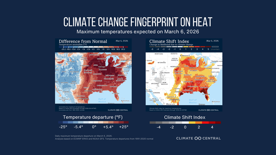
March is coming in like a lion across the central and eastern U.S. with severe weather and widespread abnormal warmth. Climate Central analysis shows that the unusually warm early springtime temperatures forecast for March 6, up to 34°F above average across the Upper Midwest, are at least twice as likely due to human-caused climate change. The climate change-fueled spring warmth will also help increase the risk of severe weather across the Central Plains, potentially leading to strong thunderstorms, large hail, and tornadoes.
Note: This event may continue beyond March 6. Use the Global Climate Shift Index map to stay updated on heat in your region.
How unusual is the forecasted heat?
- Temperatures reaching between 73°F and 90°F (23-21°C) are forecast across the Central and Eastern U.S., especially the Midwest, Mid-Mississippi Valley, and Ohio Valley on Friday, March 6.
- These conditions are 14-20°F (8-11°C) above average across the Southern U.S., and up to 34°F above average in the Upper Midwest (based on 1991–2020 averages).
- An Enhanced Risk of severe thunderstorms is forecast across eastern Kansas, Oklahoma, and western Missouri and Arkansas Friday afternoon and evening. Warm surface temperatures contribute to atmospheric instability, helping create conditions supportive of thunderstorms when combined with moisture and strong winds aloft.
- Convective Available Potential Energy (CAPE) – A measure of the atmospheric energy available for the formation of thunderstorms – has increased with warming.
-
- Since 1979, springtime has seen 10-15 more days each year with CAPE values exceeding 1,000 J/kg in parts of the central and eastern U.S.
How has climate change influenced this heat?
- Climate Shift Index (CSI) levels of 3 are forecast in Houston, Memphis, and Chicago, meaning human-caused climate change made this extreme heat at least three times more likely, signaling a significant climate change event.
- On March 6th, 116 million people across the eastern U.S. will experience a CSI 2 or higher, indicating temperatures with a strong influence from climate change.
- Temperatures made at least two times more likely by human-caused climate change are expected to impact around 2.8 million square kilometers of land — roughly the size of Argentina — during this time.
To request an interview with a Climate Central scientist, please contact Tom Di Liberto at tdiliberto@climatecentral.org.
How do we know climate change is influencing this heat?
The Climate Shift Index uses peer-reviewed methodology and real-time data to estimate how climate change has increased the likelihood of a particular daily temperature.
The end result of all of this excess heat will be an increase in early severe weather. For that here is a new article by Matthew Cappucci:
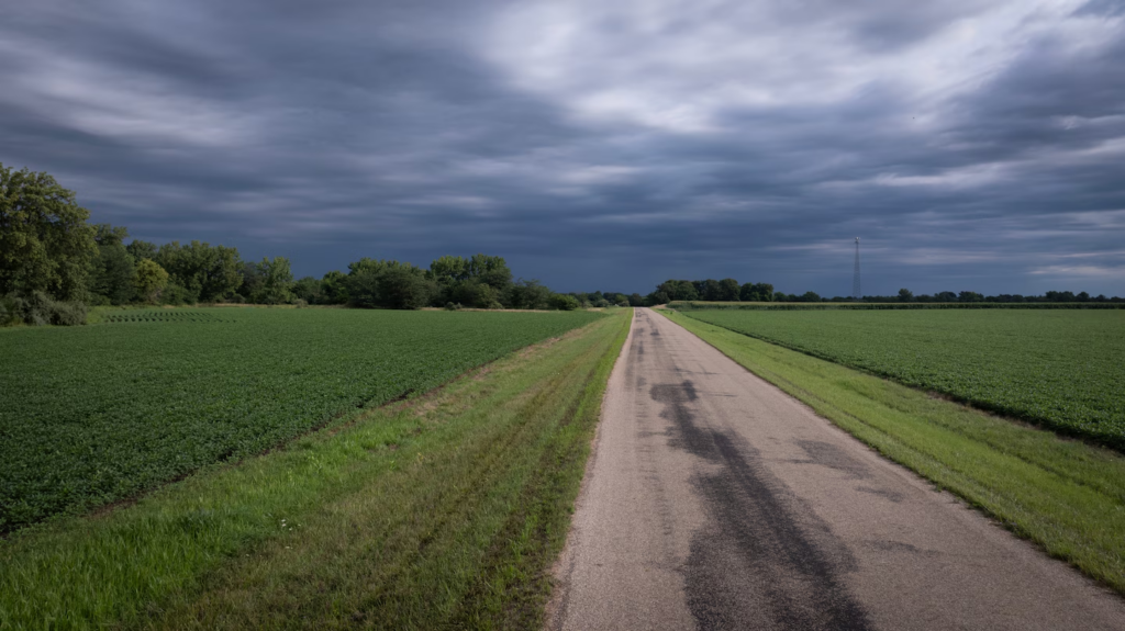
Storm clouds cover a soybean field near Clinton, Illinois. (Scott Olson/Getty Images)

Meteorological spring is here, and severe weather is about to ramp up markedly. Wednesday through Saturday will feature the potential for severe thunderstorms — particularly in central states — and there’s even the chance of a couple of tornadoes.
The National Weather Service’s Storm Prediction Center has already highlighted four consecutive days as having a severe storm risk. The most widespread and potentially significant storms are expected Friday, some of which may be rotating supercells.
March is typically when we see a sudden ramp-up of storminess as the retreating cold of winter clashes with insurgences of warm, humid springtime air from the gulf. By April, we’re in the thick of tornado season, which peaks in May and continues strong into June.
Typically, the Deep South sees its nastiest weather early in the season. Then storms spread farther north into the southern and central Plains and eventually the High Plains and Rockies by the start of meteorological summer in June.
The upcoming pattern
The jet stream — a river of swiftly moving winds in the atmosphere — is about to dip over the western United States. That allows frigid air aloft to spill south over the Rockies. Pockets of cold air, low pressure and spin pinch off from this blob of upper-level cold; we call each one a shortwave.
Individual shortwaves will eject east toward the Plains and Midwest. Ahead of them, warm, humid gulf air wafting northward will make for instability, or thunderstorm fuel. Each approaching shortwave encourages the air ahead of it to rise, generating thunderstorms. And with strong jet stream winds aloft, there’s plenty of wind energy to tap into. That’s why some of the storms could produce damaging gusts as they mix momentum to the surface. A few tornadoes are possible where changing winds with height help storms to rotate.
Daily details
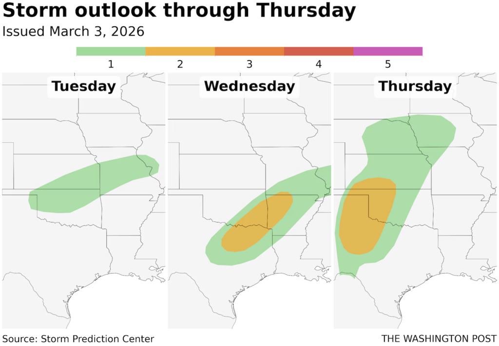
Wednesday
A slight (Level 2 out of 5) risk of severe weather has been drawn from northeast Texas to southern Illinois. It includes the Dallas-Fort Worth metroplex and Paris, Texas; southeast Oklahoma, including Idabel; western Arkansas, including Texarkana and the Interstate 30 corridor; Springfield, Missouri; and Carbondale, Illinois. Appetizer thunderstorms were ongoing to start the day, but a round of stronger storms are likely in the afternoon.Ask The Post AIDive deeper
Low pressure over Missouri is dragging a cold front east into a moisture-rich air mass. That will help another round of storms to blossom by midafternoon. Initial discrete (isolated) storms will pose the threat of hail up to ping-pong-ball size; there’s a marginal, but nonzero, risk of an isolated tornado.
By mid-evening, thunderstorms will likely merge into windy lines and clusters as they push east-northeast into the Ozarks.
Thursday
A slight (Level 2 out of 5) risk encapsulates West Texas, including Midland, Lubbock, Amarillo and the Panhandle; western Oklahoma, including Lawton, Elk City and Woodward; and southwest Kansas, including Liberal.
Low pressure in southeast Colorado will drag a dryline eastward, representing where dry, desert air impinges on moist gulf air. That may make for a few late-day supercells after 4 p.m. or 5 p.m. with some risk for hen-egg-size hail, damaging gusts or a couple of tornadoes. Confidence is increasing in a few supercells sprouting in the corridor from Amarillo, Texas, to Altus, Oklahoma, likely with hail and a tornado or two. After 10 p.m., they may merge into clusters or lines and shift northeast, perhaps reaching Oklahoma City in a weakened state overnight.
A caveat is the mid-level flow; about a mile up, winds are out of the south, parallel to the dryline. That means there won’t be steering winds to push storms off the dryline. The result? Storms may move along it and merge into clusters after a couple of hours, reducing the tornado threat but increasing the risk of damaging winds.
Friday
An enhanced (Level 3 out of 5) risk has already been drawn by the Storm Prediction Center; it stretches from Missouri’s St. Joseph and Kansas Cityto Tulsa, Oklahoma City and Ardmore in Oklahoma. A broader slight (Level 2 out of 5) risk spans from Chicago and La Crosse, Wisconsin, all the way to Dallas, Waco and Abilene in Texas; and also includes Springfield, Missouri; Wichita, Kansas;, Omaha and Lincoln, Nebraska; and Springfield, Illinois.
That covers a large amount of area. Low pressure over Sioux Falls, South Dakota, will draw an expansive warm sector northwards meaning there is a broad area where storms can form ahead of an approaching frontal system. And with changing winds with height associated with a robust jet stream dip approaching, confidence is increasing in the potential for some tornadic supercells.
“This will support a threat for supercells with strong tornadoes,” the Storm Prediction Center wrote.
It’s also probable that storms will continue into the first half of the overnight, feeding off a low-level jet stream (strong southerly winds a mile above the ground) that will ramp up around nightfall. Storms may also move repeatedly over the same areas, dumping heavy rain.
Saturday
That same front will probably get hung up along Interstate 30 from Dallas to Texarkana. It may touch off a few additional storms with wind or hail, but confidence in the position of the front, and subsequently any expected hazards, is low.
“Although an isolated severe threat will be likely in some areas, uncertainty is considerable concerning the area with the greatest severe threat,” the Storm Prediction Center wrote.
By Matthew CappucciMatthew Cappucci is a meteorologist for Capital Weather Gang. He earned a B.A. in atmospheric sciences from Harvard University in 2019, and has contributed to The Washington Post since he was 18. He is an avid storm chaser and adventurer, and covers all types of weather, climate science, and astronomy. follow on X@MatthewCappucci
Here are some “ETs” recorded from around the U.S. the last couple of days, their consequences, and some extreme temperature outlooks, as well as any extreme precipitation reports:
Here is More Climate News from Friday:
(As usual, this will be a fluid post in which more information gets added during the day as it crosses my radar, crediting all who have put it on-line. Items will be archived on this site for posterity. In most instances click on the pictures of each tweet to see each article. The most noteworthy items will be listed first.)