The main purpose of this ongoing blog will be to track planetary extreme, or record temperatures related to climate change. Any reports I see of ETs will be listed below the main topic of the day. I’ll refer to extreme or record temperatures as ETs (not extraterrestrials).😜
Main Topic: My Dire Forecast for What Will Be Major Heatwave Artex
Dear Diary. On Wednesday I issued my first post about an eye-opening March heatwave for the Southwest. Even at about 192 hours out in time, this thing looked like a slam dunk since model ensembles were in agreement:
As a consequence, I issued a note of warning to my friends Brad Friedman and Desi Doyen who’s Green News Report is essential listening to get some of the latest news on the climate crisis. I thank them for airing my warning. (just click to download a listen for that show):
HI Brad and Desi.
During one of your shows you can quote me here:
The hottest winter heatwave to ever occur across the southwestern U.S. in recorded history will commence over the weekend and peak a week from Thursday or Friday with some locations around Los Angeles and at Phoenix seeing monthly March records over 100°F and 90s up to San Francisco. Snowmelt and wildfires will become an even bigger concern from the Rockies into the western High Plains. Meanwhile a blizzard will move from the northern Plains through Michigan in the Sunday through Monday timeframe.
Both events, including some associated severe weather, will be quite newsworthy and definitely climate change related.
Cheers and keep making those much needed Green News Reports, Desi.
So, its’s now Saturday, a couple of days before major Heatwave Artex commences and about 120 hours before its heat dome peaks:
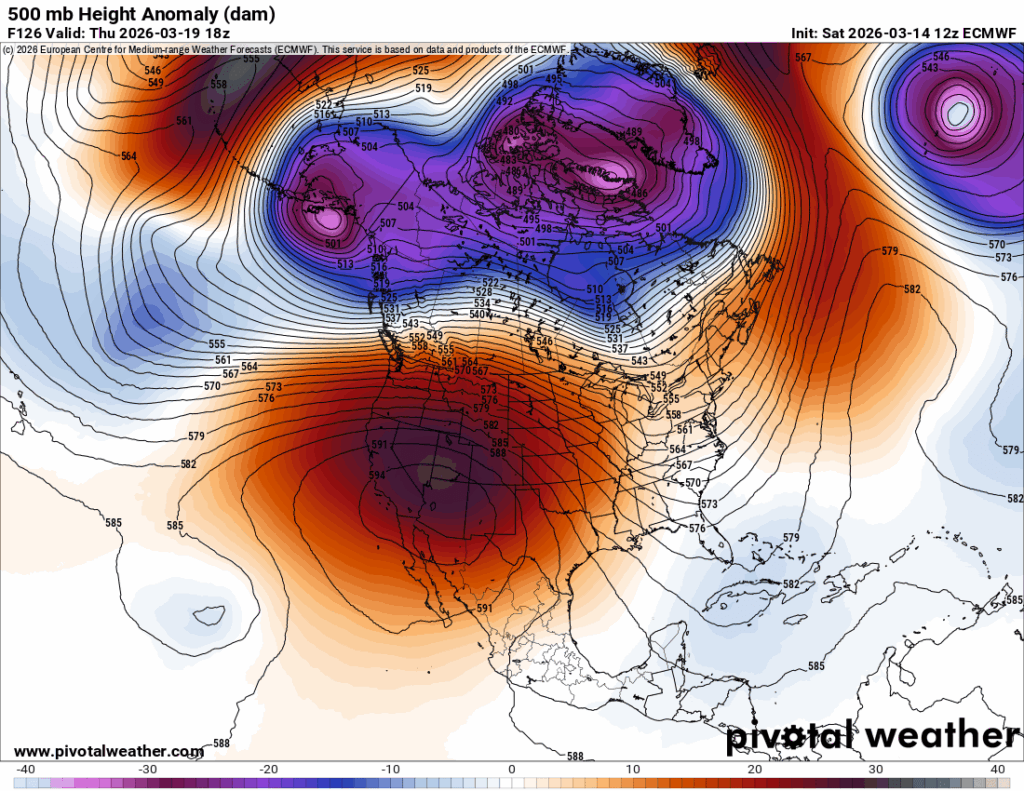
Now we have populated areas of the Southwest under heat watches, fitting my criteria for a major CAT3 when they become warnings (and before the spring equinox, no less):
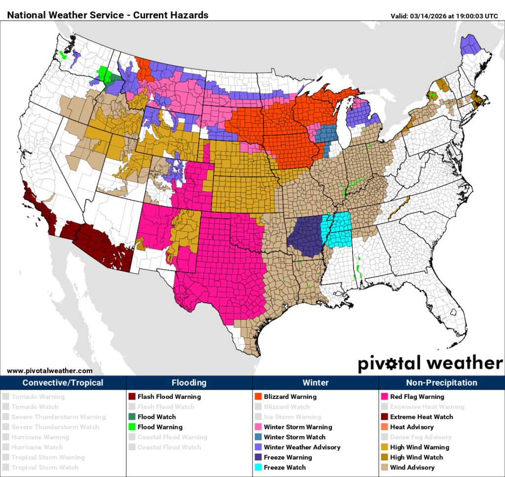
Also note the huge area of red flag and wind advisories in the Plains. We are seeing a wildfire disaster in the making, and we will be fortunate if we do not see one. And that blizzard is now highlighted in the Midwest.
Here is a recent writeup for Heatwave Artex from the Washington Post:
West Coast braces for record-breaking March heat wave. How hot will it get? – The Washington Post
A record heat dome is about to hit the West — in March
For millions of people, it will feel like summer during the final days of winter. That will worsen the region’s drought.
Updated March 12, 2026
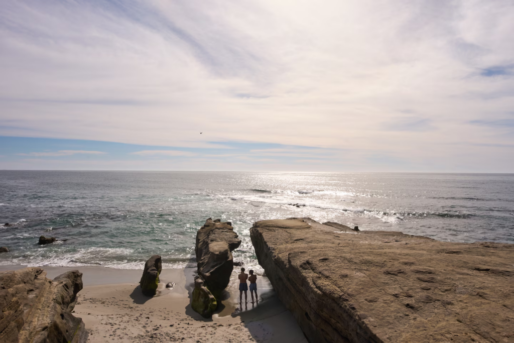
Two boys take a break from swimming in the Pacific Ocean at Windansea Beach, San Diego, under sunny skies and warm weather on Feb. 24. (Gregory Bull/AP)

By Ben Noll
A record-breaking heat dome will develop near the West Coast late this week, smashing records and sending temperatures into the triple digits through next week — when it will feel like summer during the final days of winter.
This follows the warmest start to March on record for the United States.
There are many potential firsts for March on the horizon: It could reach 100 degrees in Los Angeles next week, after record-breaking 95-degree heat on Thursday and Friday. In Phoenix next week, temperatures could exceed 100 degrees several times. It could also reach the century mark in Las Vegas.
The pattern is occurring as a marine heat wave builds offshore, an expansive area of well-above-average sea temperatures that is likely to expand as summerlike warmth arrives and intensifies into next week — following a meteorological winter with widespread record-breaking warmth and snow droughts in the West.
“I’d say the pattern next week would be the nail in the coffin of a very unforgettable winter season,” said assistant Utah state climatologist Jon Meyer, who was “quite pessimistic” about the potential impacts on the state’s water supply and drought conditions.
How hot it will get
Extreme heat will come in two main waves for the West, with around 20 to 25 million people forecast to be in moderate (Level 2 out of 4) heat risk at times into next week according to the National Oceanic and Atmospheric Administration.
At that level, excessive heat can affect those who are sensitive to it, those without cooling and/or hydration and some health systems and industries.
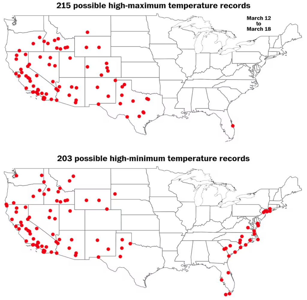
Over the next week, 418 high temperature records may be neared, tied or broken at 124 locations, shown here. (Ben Noll/The Washington Post; NOAA)
The first wave, arriving Thursday, will bring record-breaking warmth to the Southwest, including California, Nevada, Arizona and New Mexico through the weekend.
Next week, a second, stronger heat wave will arrive, with record-breaking heat spreading farther and wider — reaching Utah, Colorado, Wyoming, Idaho and Oregon.
Widespread high temperatures in the 80s, 90s and lower 100s are forecast across the Southwest through the weekend — as much as 30 degrees above average in some areas — before the bubble of heat expands and intensifies next Tuesday.
Monthly records could fall in Salt Lake City, Denver and Reno, Nevada, next week, where it will probably reach the 80s.
Climate scientist Daniel Swain described the pattern as a prolonged and very likely record-breaking heat wave that wouldn’t reached its peak for another week to 10 days. It is expected to induce rapid melt of remaining snowpack.
“This forecast is truly extraordinary for March,” he said.
The heat dome will also have a less obvious consequence: It could indirectly contribute to flooding rain in Hawaii. This strong and tall mountain of high pressure in the West will create a blockage in the atmosphere, allowing a train of storms to hit Hawaii relentlessly through this weekend.
Worsening drought

This record-breaking heat dome will contribute to worsening drought conditions across the Intermountain West.
In Utah, snowpack remains at record low levels according to Meyer. He said that it would take a foot of snow in Salt Lake City for the season to catch up with even the second-lowest seasonal snowfall total — and that a storm of that magnitude isn’t expected to come.
“The knockout punch comes in the form of Utah’s reservoirs, which are only at 40 percent of capacity right now,” Meyer said. “All this means we are likely going to see some very tangible water supply cuts and conservation efforts by the state this year.”
The weather forecast and climate outlook community in Utah was “filled with trepidation” because drought relief looked unlikely, added Meyer, stressing that much more meaningful impacts were possible for agricultural communities as water conservation efforts grow.
“Right now, every drop is going to count this year,” he said.
Across the region, New Mexico was also reporting its lowest snowpack on record and Colorado was in a similar situation. Because of several strong storms during fall and winter, California is the only state that is currently drought free.
Intensifying marine heat wave
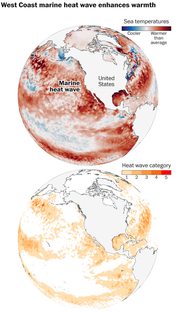
A marine heat wave will enhance warmth near the West Coast during the upcoming spell of record-breaking temperatures. The marine heat wave will also intensify further because of the heat dome. (Ben Noll/The Washington Post; NOAA/OISST/CRW)
Sea surface temperatures off the coast of Southern California have risen as much as five degrees above average for the time of year, causing a strong, Category 2 marine heat wave to develop.
These unusually warm waters will provide a boost to air temperatures near the coast, especially at night, preventing them from dropping off as much as they otherwise would.
The heat dome will bring light winds, plentiful sunshine and unseasonably high temperatures, which will prevent cooler, deeper waters from churning up. The sea surface will warm, further intensifying the marine heat wave.
This can contribute to a feedback loop, by which extra warmth in the sea adds to warmth on land and vice versa.
As the climate warms, marine heat waves are becoming more frequent, severe and long-lasting.
“A strong to severe marine heatwave is ongoing off the coast of California,” wrote Colin McCarthy, a storm chaser affiliated with the University of California at Davis.
In early March, ocean temperatures reached the mid- to upper 60s at Scripps Pier in La Jolla, California.
“That’s the average ocean temperature for mid-June,” McCarthysaid.
By Ben Noll Ben Noll is a meteorologist passionate about explaining the why behind the weather, extreme events and climate trends. He has expertise in data analysis, supercomputer-driven graphics and forecasting weather worldwide. follow on X@BenNollWeather
Here are some “ETs” recorded from around the U.S. the last couple of days, their consequences, and some extreme temperature outlooks, as well as any extreme precipitation reports:
Here is More Climate News from Saturday:
(As usual, this will be a fluid post in which more information gets added during the day as it crosses my radar, crediting all who have put it on-line. Items will be archived on this site for posterity. In most instances click on the pictures of each tweet to see each article. The most noteworthy items will be listed first.)