The main purpose of this ongoing blog will be to track planetary extreme, or record temperatures related to climate change. Any reports I see of ETs will be listed below the main topic of the day. I’ll refer to extreme or record temperatures as ETs (not extraterrestrials).😜
Main Topic: Rare Middle East Storm with Climate Change Signatures Could Bring Floods, Damaging Winds and Tornadoes
Dear Diary. The Arabian Peninsula is one of the driest places on this Earth, so when a weather system is strong enough to produce yearly amounts of rain at some locations there in just a fee hours, that is big news. Something like the system I am reporting on today happened in 2024. So is climate change involved here?
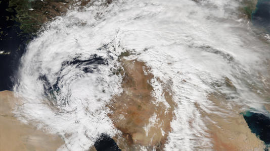
Rare Middle East storm threatens flooding, damaging winds and tornadoes© Image Credit: NASA – Public domain/Wiki Commons
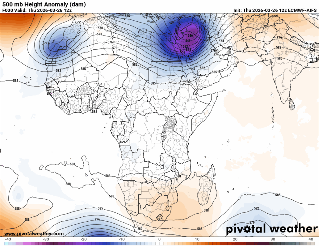
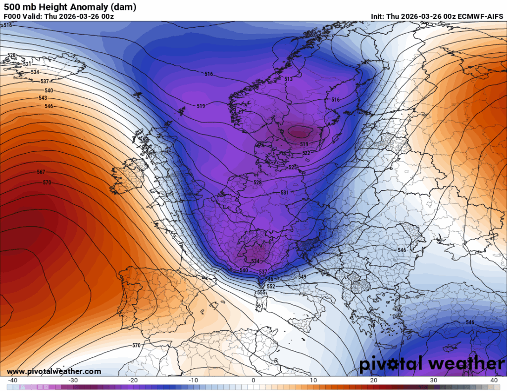
More than likely looking at the way cold troughs are being pinched off from the main jet stream cutting across Europe:
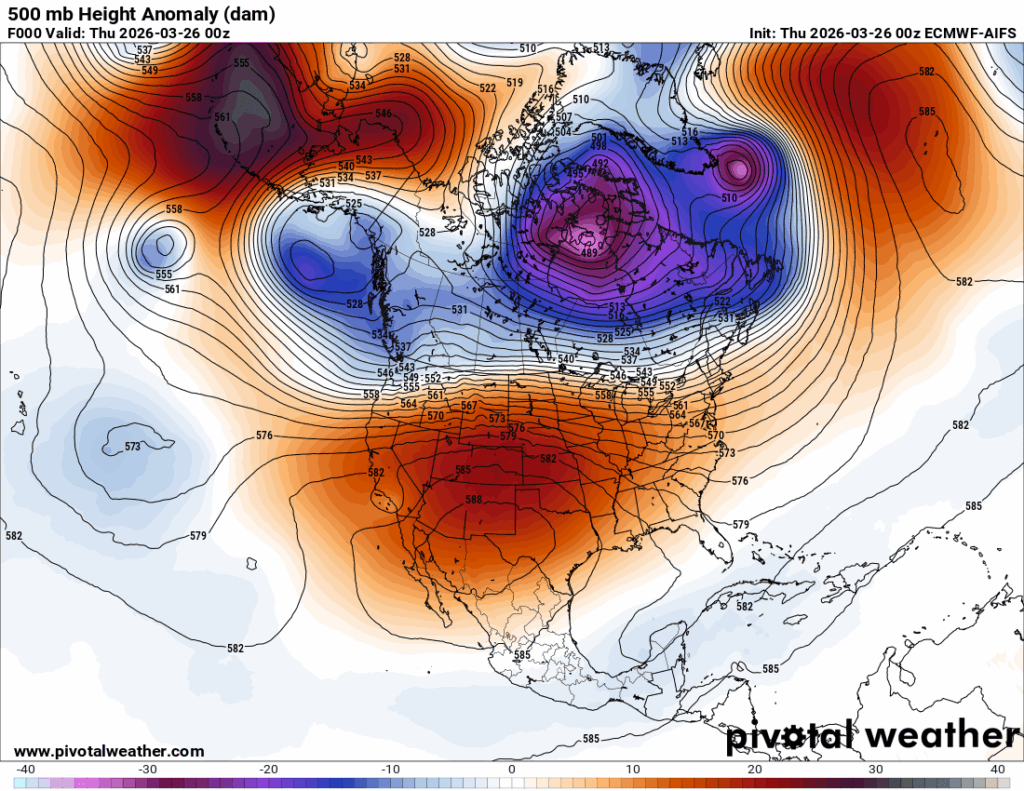
All of this in response to that huge heat dome that developed over the southwestern U.S. downstream and a corresponding ridge in the middle of the Atlantic:
Here are more details from the Washington Post:
Rare Middle East storm could bring hail, damaging winds and tornadoes – The Washington Post
Rare Middle East storm could bring floods, damaging winds and tornadoes
Severe weather threatens Dubai, as well as areas affected by the war with Iran.
Updated March 25, 2026

A boy crosses a street filled with rain water in Sharjah, United Arab Emirates, on Monday. (AP)
By Matthew Cappucci and Ben Noll
A Tornado Alley-style storm system is about to hit the Middle East — in a virtually unheard of atmospheric setup for the region.
Parts of the Arabian Peninsula and Persian Gulf could be slammed by strong to severe thunderstorms Thursday, bringing the potential for damaging winds, destructive hail and a few tornadoes. Large expanses of the desert may flood, in some cases picking up a year’s worth of rainfall in three days. At least one model shows storm effects stretching from parts of Iran toward Dubai and Abu Dhabi on Thursday afternoon.
Major highways and airports could be inundated, adding complications to an already challenging geopolitical crisis affecting the Middle East, as the U.S. and Israel war with Iran continues.
Heavy rain, flooding to hit Middle East
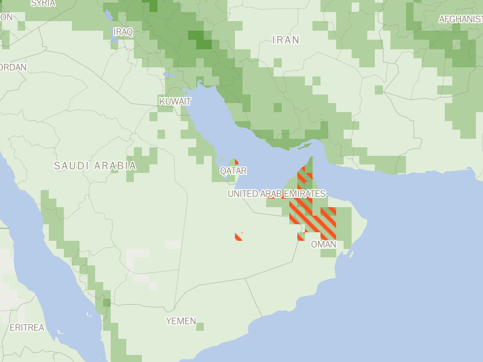
A year’s worth of rain could fall in red hatched areas Source: ECMWF
This is not a part of a world that often sees this kind of severe weather. Although that may be shifting.
An analysis by The Washington Post suggests northern Oman, Dubai and Abu Dhabi are at an increasing risk of heavy rain and flood events in part because of climate change. As the atmosphere holistically warms and flow patterns increase, observations confirm increased integrated vapor transport — or the movement of water vapor — into the region. That’s reflected in increasingly common heavy-rain events.
Dubai, for instance, averages 4 inches of rain annually. The opulent enclave could see 3 to 6 inches by the end of the week.
A similar event between April 15-17, 2024, dumped 6.45 inches of rain on Dubai International Airport, forcing the cancellation of more than 1,200 flights. Runways were left underwater.
This time, though, the storm system could feature a few rotating thunderstorms, and there’s the exceptionally unusual risk of tornado activity in the desert.
The storm system was taking shape Tuesday. A developing upper-level low — or pocket of cold air, low pressure and spin aloft — was present over the Mediterranean. To the south, the jet stream — a river of swiftly moving winds in the upper atmosphere — is squeezed. Like a narrowed garden hose, the flow accelerates, meaning strong winds in the developing jet stream dip.Ask The Post AIDive deeper
Simultaneously, a surface low-pressure system will strengthen near Baghdad on Wednesday. Ahead of it, moisture will surge north, introducing instability, or thunderstorm fuel. The same surface low will swing a cold front east, kicking humid air pockets upward and generating thunderstorms.
By Wednesday midday, the approaching jet stream dip will swing more dramatically southeast over Egypt and the Red Sea before pivoting over Saudi Arabia early Thursday. Any thunderstorms that are ongoing over the Persian Gulf or Gulf of Oman will feel those fierce jet stream winds aloft.
Surface winds near a warm front will be out of the southeast, but the jet stream winds aloft will be screaming out of the southwest. Changing winds with height, meanwhile, could encourage storms to rotate. That means a couple of rotating supercells can’t be ruled out.
Cold air aloft, meanwhile, could allow large hail to form — possibly the size of tennis balls or bigger. Dry air at the mid-levels of the atmosphere will help supercooled water droplets efficiently latch onto growing hailstones.
Early Tuesday, the Labor Ministry in Qatar issued an alert regarding the adverse weather.
“Employers are advised to adhere to occupational safety and health guidelines and to provide suitable protective measures to safeguard workers,” the statement said.
In Egypt, the education minister said school would be canceled for students, teachers and staffs Wednesday and Thursday ahead of the expected unstable weather. The country’s Health and Population Ministry raised its preparedness level to ensure medical resources and needed supplies.
Any supercell thunderstorms could produce large, damaging hail up to the size of eggs, damaging straight-line winds near 60 mph and torrential rainfall, as well as the outside chance of an isolated tornado or two. Waterspouts could accompany any offshore thunderstorms, posing a hazard to maritime commerce.
The European ECMWF model simulates a broken band of rotating thunderstorms stretching from roughly Khuzestan province in Iran southeast toward Dubai and Abu Dhabi on Thursday afternoon.
There are two possibilities for how “storm mode” will evolve. Some models simulate a developing QLCS, or a quasi-linear convective system — in other words, a squall line with embedded kinks of rotation. That would produce damaging straight-line winds and a few tornadoes or waterspouts. Any squall line that pushed east far enough to encounter drier surface air in eastern Saudi Arabia near the Yemen-Oman border would potentially kick up dust and generate localized dust storm conditions.
Alternatively, if the squall line remains broken, a handful of lone, discrete supercell thunderstorms could form. Those would have a greater hail risk and could also produce a couple of tornadoes.
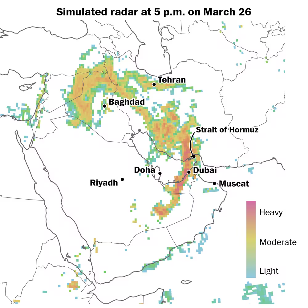
Simulated radar imagery shows a line of strong-to-severe thunderstorms crossing portions of Iran, the United Arab Emirates and Saudi Arabia from late Thursday into early Friday local time. (Ben Noll/The Washington Post; NCEP/GFS)
Moreover, the overarching setup also indicates the possibility of flooding rains. The same jet stream dip could drive divergence, or the spreading of air aloft. That spreading upstairs helps lift air and moisture from below. Rising moisture may fuel increased rainfall rates.
That’s why parts of the desert could see 3 to 6 inches of rain, with locally greater amounts.
Because fine, grainy sand struggles to absorb water, flooding is likely — especially in the urban corridor from Abu Dhabi to Dubai.
Meanwhile, there are indications of additional strong storms and heavy rainfall into early April.Ask The Post AIDive deeper
Heba Farouk Mahfouz contributed to this report.

By Matthew CappucciMatthew Cappucci is a meteorologist for Capital Weather Gang. He earned a B.A. in atmospheric sciences from Harvard University in 2019, and has contributed to The Washington Post since he was 18. He is an avid storm chaser and adventurer, and covers all types of weather, climate science, and astronomy.follow on X@MatthewCappucci

By Ben NollBen Noll is a meteorologist passionate about explaining the why behind the weather, extreme events and climate trends. He has expertise in data analysis, supercomputer-driven graphics and forecasting weather worldwide. follow on X@BenNollWeather
Here are some “ETs” recorded from around the U.S. the last couple of days, their consequences, and some extreme temperature outlooks, as well as any extreme precipitation reports:
Here is More Climate News from Friday:
(As usual, this will be a fluid post in which more information gets added during the day as it crosses my radar, crediting all who have put it on-line. Items will be archived on this site for posterity. In most instances click on the pictures of each tweet to see each article. The most noteworthy items will be listed first.)