The main purpose of this ongoing blog will be to track planetary extreme, or record temperatures related to climate change. Any reports I see of ETs will be listed below the main topic of the day. I’ll refer to extreme or record temperatures as ETs (not extraterrestrials).😜
Main Topic: Rapid Snow Melt-Off in American West Stuns Scientists
Dear Diary. To me it’s no wonder that the U.S. West is having rapid if not stunning snow melt given that the country is just coming off its warmest March on record:
As depicted above, the West had the warmest anomalies across the Conus. This is a slam dunk event pointing to the fact that the Earth is warning due to our long turn burning of fossil fuels.
Here are some particulars on western snow melt during 2026 from the Guardian:
‘On a whole other level’: rapid snow melt-off in American west stuns scientists
Experts say brutal March heat has left critical snowpack at record-low levels – and key basins in uncharted territory
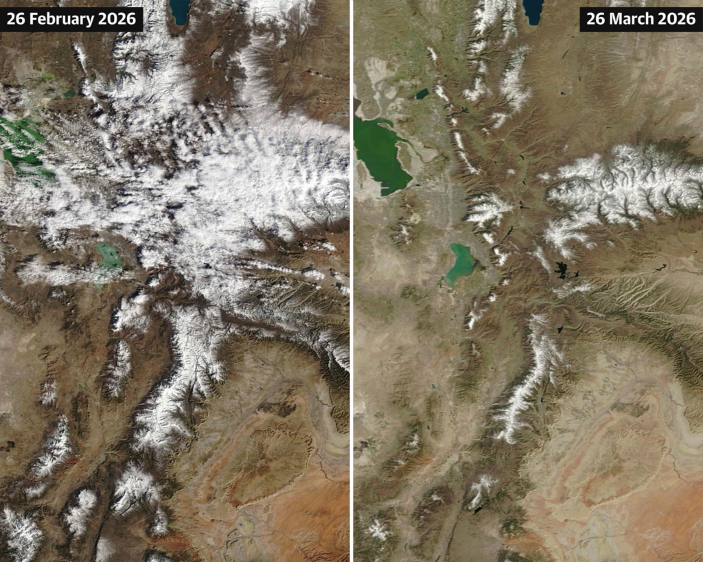
Nasa satellite images show how the snowpack in Utah has diminished between late February and late March. Illustration: Guardian Design/Nasa Worldview
Wed 1 Apr 2026
Snow surveys taking place across the American west this week are offering a grim prognosis, after a historically warm winter and searing March temperatures left the critical snowpack at record-low levels across the region.
Experts warned that even as the heat begins to subside, the stunning pace of melt-off over the past month has left key basins in uncharted territory for the dry seasons ahead. Though there’s still potential for more snow in the forecast, experts said it will probably be too little too late.
“This year is on a whole other level,” said Dr Russ Schumacher, a Colorado State University climatologist, speaking about the intense heat that began rapidly melting the already sparse snowpack in March. “Seeing this year so far below any of the other years we have data for is very concerning.”
Acting as a water savings account of sorts, snowpacks are essential to water supply. Measurements taken across the west during the week of 1 April are viewed as important indicators of the peak amounts of water that might melt into reservoirs, rivers and streams and across thirsty landscapes through the summer.
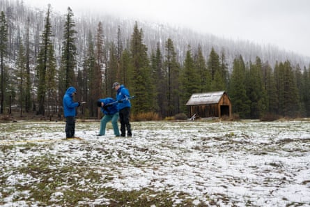
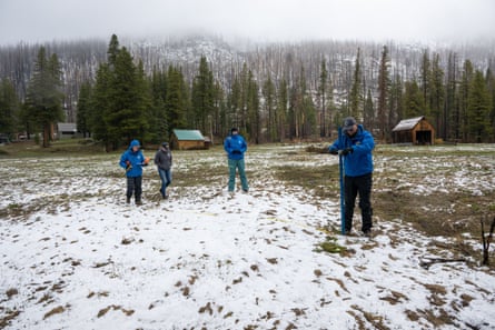
During a critical survey in California’s Sierra Nevada on Wednesday, grass and mud could be seen through the thin white patchwork as state officials attempted to measure the meager snowpack.
“Normally we’d be standing right here,” Andy Reising, manager of California department of water resource’s snow surveys and water supply forecasting unit said, gesturing at chin height. The 5ft-tall tool typically thrust deep into the high berms on 1 April poked into the brown earth next to him. “There is actually no measurable snow.”
With zero depth and zero water content, this year’s annual April snow survey conducted at Phillips Station, was the second worst on record, beaten only by 2015 when officials “walked across a dry field”, Reising said.
It’s not just the amount of snow left on mountaintops that’s concerning experts, but the amount of moisture still frozen within them. “Snow water equivalent” (SWE), a measurement of what could melt off to supply natural and manmade systems, is exceptionally low.
California’s Sierra Nevada had just 4.9in of SWE, or 18% of average on Wednesday, according to the state’s department of water resources.
In the Colorado River headwaters, an important basin that supplies more than 40 million people across several states, along with 5.5m acres of agriculture, 30 tribal nations, and parts of Mexico, had just over 4in of SWE on Monday, or 24% of average. That’s less than half what was previously considered the record low.
Schumacher said the incoming storm could slow the early melting but won’t be enough to pull the basins back from the brink. Snow water equivalent measurements going into April were at levels typically seen in May or June, after months of melt-off, according to Schumacher.
The issue is extremely widespread. Data from a branch of the US Department of Agriculture (USDA), which logs averages based on levels between 1991 and 2020, shows states across the south-west and intermountain west with eye-popping lows. The Great Basin had only 16% of average on Monday and the lower Colorado region, which includes most of Arizona and parts of Nevada, was at 10%. The Rio Grande, which covers parts of New Mexico, Texas and Colorado, was at 8%.
“This year has the potential of being way worse than any of the years we have analogues for in the past,” Schumacher said.
‘Nothing short of shocking’
Even with near-normal precipitation across most of the west, every major river basin across the region was grappling with snow drought when March began, according to federal analysts. Roughly 91% of stations reported below-median snow water equivalent, according to the last federal snow drought update compiled on 8 March. Water managers and climate experts had been hopeful for a March miracle – a strong cold storm that could set the region on the right track. Instead, a blistering heatwave unlike any recorded for this time of year baked the region and spurred a rapid melt-off.
“March is often a big month for snowstorms,” Schumacher said. “Instead of getting snow we would normally expect we got this unprecedented, way-off-the-scale warmth.”
More than 1,500 monthly high temperature records were broken in March and hundreds more tied. The event was “likely among the most statistically anomalous extreme heat events ever observed in the American south-west”, climate scientist Daniel Swain said in an analysis posted this week.
“Beyond the conspicuous ‘weirdness’ of it all,” Swain added, “the most consequential impact of our record-shattering March heat will likely be the decimation of the water year 2025-26 snowpack across nearly all of the American west.”
Calling the toll left by the heat “nothing short of shocking”, Swain noted that California was tied for its worst mountain snowpack value on record. While the highest elevations are still coated in white, “lower slopes are now completely bare nearly statewide”.
The snow is melting so fast in the Sierra that, if it continues at its current rate, little would be left by early April. It’s unlikely to keep up this astounding pace, but there’s still high potential for the earliest melt-off on record in the state, according to Swain.
“It feels like we skipped spring this year and dropped straight into a summer heatwave,” said Karla Nemeth, the DWR director, during Wednesday’s briefing. “What should be gradual snowmelt happened suddenly weeks ago.” This year’s was one of the quickest surveys they’d had, she added.
But with warmth on the rise, there has already been a notable shift.
“This year has featured many of the factors California is expected to see more of in the future: winters with more rain and less snow and stretches of hot and dry conditions,” Reising said, in a statement provided to the Guardian before the measurement. After the results were in, he noted that six of the lowest 1 April snowpacks have occurred since 2007.
California’s reservoirs are nearly all filled beyond their historic averages, however, thanks to a series of robust rains. While this will help support water supplies, it will also mean fast-melting snow may be harder to capture.
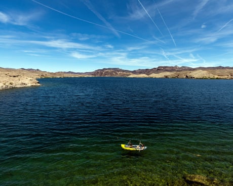
In the Colorado River Basin, the situation could be even more dire. The two largest reservoirs on the Colorado River are Lake Mead and Lake Powell, which together account for about 90% of storage, are 25% and 33% full accordingly, as of 29 March, and there is little to fill them.
Already officials are in the process of relocating a floating marina on Lake Powell in anticipation of the quickly receding water levels, as experts warn the vital reservoir could drop to the lowest levels recorded since it was filled in the 1960s. If they fall far enough, the system would cease to function altogether. So-called “deadpool” – when water isn’t high enough to pass through the dams, generate hydroelectric power, and be distributed downriver – would be catastrophic.
The Colorado River has been overdrawn for more than a century but rising temperatures and lower precipitation are putting more pressure on the system that depended on by cities, farms, industries and wildlife across the west. The extreme conditions have added more urgency and greater tensions to fraught negotiations over who will bear the brunt of badly needed cuts. Seven states that have blown past two key deadlines are still locked in a stalemate over how the river’s essential resources will be managed through a hotter and drier future.
But the dire snowpack numbers have pushed some municipalities to initiate early water restrictions. Local officials in Salt Lake City, Utah, have called on residents and businesses to begin conserving, with a goal to cut up to 10 m gallons, while city facilities will curb 10% of their use. Across Colorado, there are local orders that limit lawn watering, and in Wyoming residents were warned that full restrictions on outdoor irrigation could come as early as May. Farmers and ranchers across the west are also having to make hard decisions and big adjustments with smaller allocations of water and a recognition that supplies will be strained.
A troubling outlook for fire season
The fast-melting snow is expected to have profound impacts on drinking water supply, agriculture production, and outdoor recreation. It could also set the stage for bigger blazes.
“Unless there’s a major change in the weather patterns and we somehow pull out some sort of miracle springtime precipitation, we’re looking at an extended fire season,” said Dr Joel Lisonbee, senior associate scientist at the Cooperative Institute for Research at the University of Colorado Boulder, noting that there was not a one-to-one relationship between snowpack and fire, but they are connected.
“In any sort of fire situation, you need some spark or ignition,” he said. Landscapes that would typically spend longer underneath a protective blanket of snow will become more primed to burn. Fire season may “begin weeks to months earlier than what we would usually expect”, he said. “These high temperatures and low snowpack will lead to a rapid drying of the vegetation that’s around, and that will lead to this early start.”
Dozens of large destructive fires have already erupted in recent weeks across the Intermountain West and the High Plains, spurred by extreme heat and low moisture. More than 1.5m acres have already burned this year across the US, more than double the 10-year average.
While Schumacher said he expects this year to be a standout one, the climate crisis is fueling warming trends that climate scientists have long warned will leave the west hotter and drier. Seasons with snow in the US west are shrinking while high fire risks stretch across more months.
“Climate change is going to result in a lot of these extreme events worsening,” said Dr Abby Frazier, a climatologist and assistant professor at Clark University, who added that compound events, where hazards overlap or occur in quick succession, are on the rise. The heat and the drought this year, served as a one-two punch, and will work together to produce greater dangers from fire.
She emphasized the need to take transformative action, and prioritize adaptation and mitigation. “It is heartbreaking to see it all playing out as we have predicted for so long,” she said. “The changes we have teed up for ourselves are going to be catastrophic.”
More:
Here are some “ETs” recorded from around the U.S. the last couple of days, their consequences, and some extreme temperature outlooks, as well as any extreme precipitation reports:
Here is More Climate News from Thursday:
(As usual, this will be a fluid post in which more information gets added during the day as it crosses my radar, crediting all who have put it on-line. Items will be archived on this site for posterity. In most instances click on the pictures of each tweet to see each article. The most noteworthy items will be listed first.)