The main purpose of this ongoing blog will be to track planetary extreme, or record temperatures related to climate change. Any reports I see of ETs will be listed below the main topic of the day. I’ll refer to extreme or record temperatures as ETs (not extraterrestrials).😜
Here is a new feature for this blog, which I will add daily. This is the latest inciteful Green News Report from my friends Desi Doyen and Brad Friedman at Progressive Voices. Hit ‘continue reading,’ listen, then hit return to see my daily topics:

Green News Report with Brad Friedman & Desi Doyen
Episode: 10/1/2026 — More info…
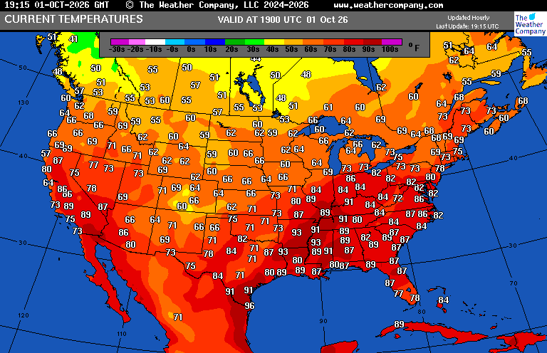
Dear Diary. By now most people know that a warmer atmosphere in our warming world holds more moisture. That is exactly the dynamics faced by the United States as the calendar rolls from September into October. The lower 48 states have only cooled off slightly from record levels that occurred from our record hot summer that extended through much of September. Normal early fall cold fronts that cool and dry out the continent have only penetrated the northern and Eastern states, leading the Southwest and south-central states warm and moist. On October 1st temperatures across the South remain summerlike:
Due to s strong El Niño that arguably has been strengthened by climate change, the eastern Pacific has been very active with many hurricanes forming in the region. One hurricane named Polo made landfall Tuesday in the Baja Peninsula and caused local flooding in the Southwest. Another named Rachel is being influenced by prevailing winds which are streaming its moisture northward into the U.S. where flooding remains a big problem:

Here are more details on flooding from the past week and currently by Irene Sans, Bob Henson and Dr. Jeff Masters writing for Yale Climate Connections:
Tropical moisture, stalled front fueling flood threat across the Central Plains
A pipeline of tropical moisture is feeding a slow-moving storm system, unleashing repeated downpours from Texas to the Central Plains.


by Irene Sans, Bob Henson and Jeff Masters
October 1, 2026
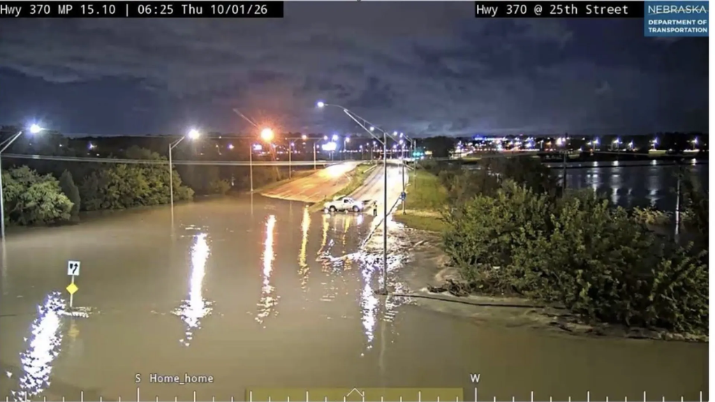
Water floods Highway 370 and 25th Street in Bellevue, Nebraska, early Thursday morning, October 1, 2026. (Image credit: Nebraska Department of Transportation, via Nebraska Public Media)
Amoisture-loaded weather pattern is producing rounds of heavy rain and an increasing flood threat across the central United States. Tropical moisture from former Hurricane Polo, additional Pacific moisture from Hurricane Rachel, and humid air flowing north from the Gulf of Mexico are interacting with a slow-moving frontal boundary across the Plains.
The result is an environment capable of producing repeated thunderstorms and torrential rainfall from Texas and Oklahoma northward into Kansas, Missouri, and portions of the Midwest. These features produced several water rescues across Arizona and New Mexico earlier this week after roads flooded and river levels rose. The combination of these multiple atmospheric features, along with their slow movement, is allowing thunderstorms to repeatedly cross some of the same areas. Meteorologists call this “training” because thunderstorms behave like train cars following the same track.
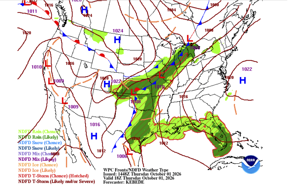
Figure 1. Surface analysis of the United States depicting moisture surge extending from South Texas through the Midwest. A slow-moving front will continue to bring rounds of heavy rains over Texas through Friday. (Image credit: National Weather Service)
Tropical moisture goes well beyond a storm’s name
After moving inland from the eastern Pacific and weakening over Mexico, Hurricane Polo lost its organized tropical circulation. However, a considerable amount of tropical moisture remained and was pulled northeastward into the southern and central Plains.
Notably, at least three eastern Pacific hurricanes contributed to torrential rains across the Southwest in September: Marie, Odalys, and Polo. Now, a bit of Hurricane Rachel’s moisture can be added to the mix. How much of Rachel’s moisture is contributing to the heavy rains in the Central Plains? Depends on which level of the atmosphere we analyze and how deep we dig into air-parcel trajectories.
Hurricanes lose their organization, including their maximum sustained winds, after making landfall, but their moisture can remain prolific. That moisture can become absorbed into a larger weather system, travel hundreds of miles from the original cyclone, and contribute to flooding far inland. This is why residents are always reminded that a system, or its remnants, can still bring catastrophic impacts even if the system no longer has a name.
As Polo’s remnant moisture reached the Plains, it encountered a developing low-pressure system and frontal boundary. The front has focused showers and thunderstorms, helping convert deep tropical moisture into widespread heavy rainfall. Warm, moisture-rich air flowing northward encounters the front and is forced upward. As the air rises and cools, its abundant water vapor condenses into clouds, thunderstorms, and heavy rain.
A slow-moving front creates a train of storms
Normally, a progressive cold front might produce a line of thunderstorms before quickly moving east. But in the current case, the frontal boundary is moving much more slowly. That creates the possibility of thunderstorms repeatedly developing along the same corridor. Storms can also move parallel to the boundary, causing several thunderstorms to cross the same communities.
Training can produce enormous differences in rainfall over relatively short distances. One community might receive an inch of rain, while another nearby location receives several inches because repeated thunderstorms pass overhead.
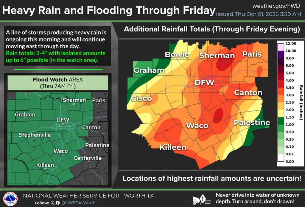
Figure 2. Rainfall totals between Thursday and Friday across North Texas. Dangerous, possibly life-threatening flooding persists. (Image credit: NWS-Fort Worth)
Gulf of Mexico moisture adds to an already bad combination in the Plains
Texas is being impacted on a large scale in part because of its location. Humid air from the Gulf of Mexico is flowing northward into Texas and the Plains. Meanwhile, moisture from the eastern Pacific is streaming northeastward across Mexico.
Hurricane Rachel is another part of that broader Pacific moisture supply. Satellite imagery shows Rachel’s moisture streaming northward over Mexico, where stronger winds higher in the atmosphere catch it and transport it toward the southern United States.
The Plains are therefore dealing with several moisture sources simultaneously: Polo’s remnants, the Gulf of Mexico, and additional eastern Pacific moisture associated with the broader environment around Rachel.
Flood watches extend hundreds of miles
Central Texas is especially sensitive to intense rainfall. The Hill Country contains numerous creeks, rivers, and low-water crossings that can respond rapidly when torrential rain falls over a short period. Urban areas face a different problem. Intense rainfall can overwhelm storm drains and quickly flood roads, intersections, and underpasses.
Recent dry conditions across parts of the region do not necessarily eliminate that threat. Extremely dry or compacted soil may initially struggle to absorb sudden heavy rainfall. If rain falls faster than the ground can absorb it, water runs across the surface and collects in low-lying areas.
Flood watches extend from the Texas-Mexico border near Langtry through South Texas and northward to the Dallas-Fort Worth Metroplex, reaching areas just south of Oklahoma City.
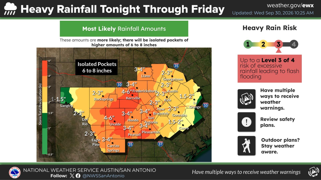
Figure 3. Rainfall totals between Thursday and Friday across the I-35 corridor between Georgetown and San Antonio. Heaviest rains are forecast near I-35 Thursday afternoon and will move east of I-35 slowly by Friday morning. Dangerous flooding, possibly life-threatening, persists. (Image credit: NWS-Austin/San Antonio)
By Thursday morning, a few flash flood warnings had already been issued. These warnings indicate that flash flooding is occurring, imminent, or expected and that rapidly rising water could pose a life-threatening danger.
The threat does not end in Texas and Oklahoma. Polo’s remnant moisture and the larger storm system are also supporting rain and thunderstorms farther north into Kansas, Missouri, and portions of the Midwest. Again, the greatest concern will be in locations where thunderstorms repeatedly track over the same watersheds. Heavy rain may also hurt agriculture by saturating fields and interrupting harvest operations.
Rainfall recorded and record rainfall
Exactly where the highest rainfall totals occur will depend on where the front stalls and where bands of training thunderstorms become established. Across the central and southern Plains, plenty of moisture is available. The biggest question is exactly where — and how quickly — the atmosphere unloads it.
Much of the heavy rain came in a burst of training showers and thunderstorms Wednesday night, with lines of torrential rain moving northeast across the same areas as the larger complex moved only slowly eastward.
The rainfall was fueled by the arrival of the remnant circulation and moisture from former Hurricane Polo. The thunderstorms evolved into a mesoscale convective system (MCS) over eastern Nebraska on Wednesday evening before progressing into Iowa overnight.
Des Moines fell just short of breaking its September precipitation record of 14.81 inches, established in 1914. Monthly precipitation reached 14.50 inches, still making it the third-wettest month in Des Moines history.
Rainfall of 4.74 inches in Omaha, Nebraska, marked its ninth wettest day on record (period of record: Jan. 1, 1871, to Sept. 29, 2026).
| Rank | Rainfall | Date |
|---|---|---|
| 1 | 6.46″ | Aug. 7, 1999 |
| 2 | 6.30″ | Aug. 12, 1932 |
| 3 | 6.24″ | Sept. 7, 1965 |
| 4 | 6.17″ | Aug. 20, 2018 |
| 5 | 5.74″ | Sept. 23, 2015 |
| 6 | 5.69″ | Sept. 28, 1923 |
| 7 | 5.30″ | June 3, 2014 |
| 8 | 5.02″ | June 17, 1875 |
| 9 | 4.74” | Sept. 30, 2026 |
| 10 | 4.64″ | Aug. 26, 1903 |
Rainfall of 6.15 inches at Lincoln, Nebraska marked it the wettest calendar day in 139 years of recordkeeping — and by a considerable margin. The previous record was 5.45 inches, set on Aug. 29, 1910.
| Rank | Rainfall | Date |
|---|---|---|
| 1 | 5.45″ | Aug. 29, 1910 |
| 2 | 5.42″ | July 25, 1990 |
| 3 | 4.86″ | July 1, 1957 |
| 4 | 4.70″ | Sept. 28, 1923 |
| 5 | 4.68″ | Sept. 8, 1989 |
| 6 | 4.59″ | June 24, 1963 |
| 7 | 4.29″ | July 1, 2024 |
| 8 | 4.27″ | Aug. 16, 1900 |
| 9 | 4.24″ | June 23, 1985 |
| 10 | 4.22″ | Sept. 9, 1914 |
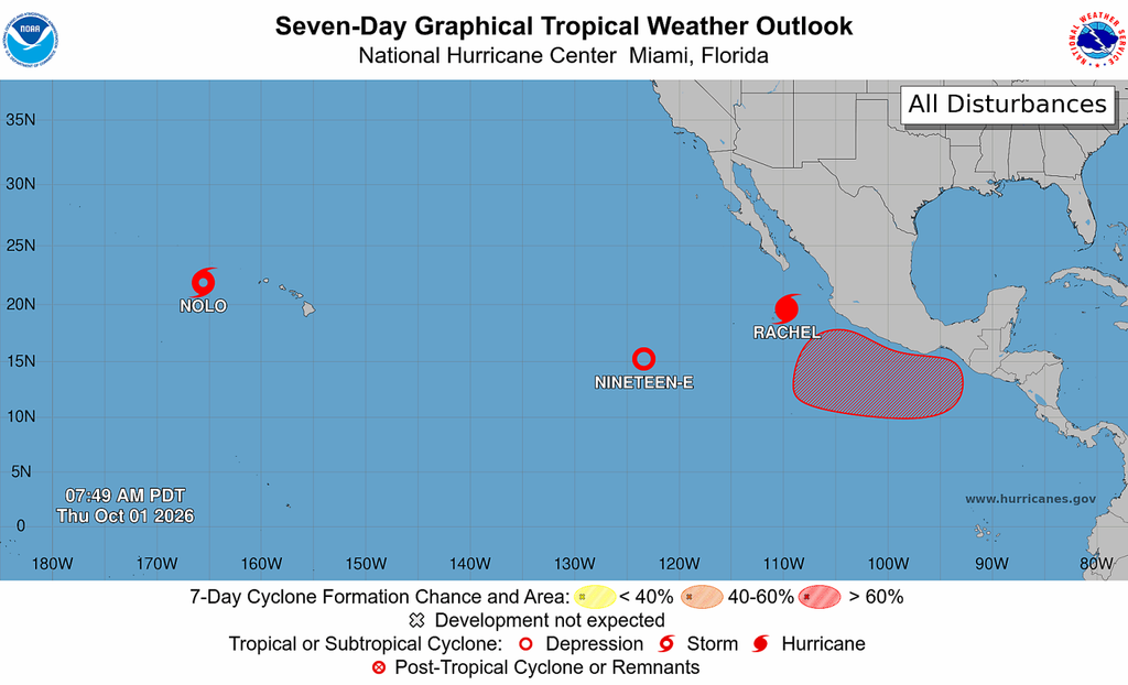
Figure 4. A wide view of the Central and Eastern Pacific on Thursday at 11 a.m. EDT. (Image credit: NHC)
Meanwhile, in the tropics…
The Atlantic has returned to sleep mode. According to the National Hurricane Center, no tropical activity is forecast during the next seven days.
In the Pacific, Nolo remains a tropical storm as it moves farther away from Hawaii, but is still forecast to regain hurricane status through the weekend. The extreme western Hawaiian Islands are under a Hurricane Warning as Polo moves south, and rainbands and wind will radiate over the region through Friday night.
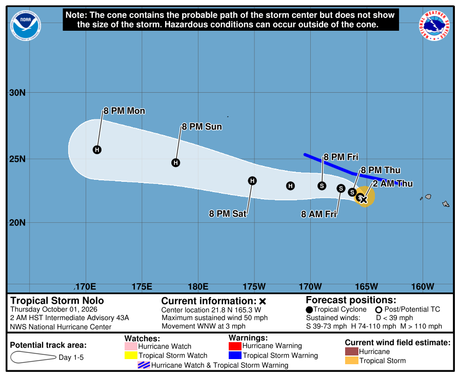
Figure 5. The official track of Polo, issued Thursday at 11 a.m. EDT on October 1, 2026, shows Polo regaining hurricane status over the weekend. (Image credit: NHC)
Rachel is a Category 2 hurricane moving westward, away from Mexico. It is forecast to intensify into a major hurricane, continuing to add to the season’s Accumulated Cyclone Energy (ACE), but it is not currently threatening land. A new system, Tropical Depression 19-E, is also over the open waters of the eastern Pacific and well away from land. It is forecast to dissipate by Thursday evening.
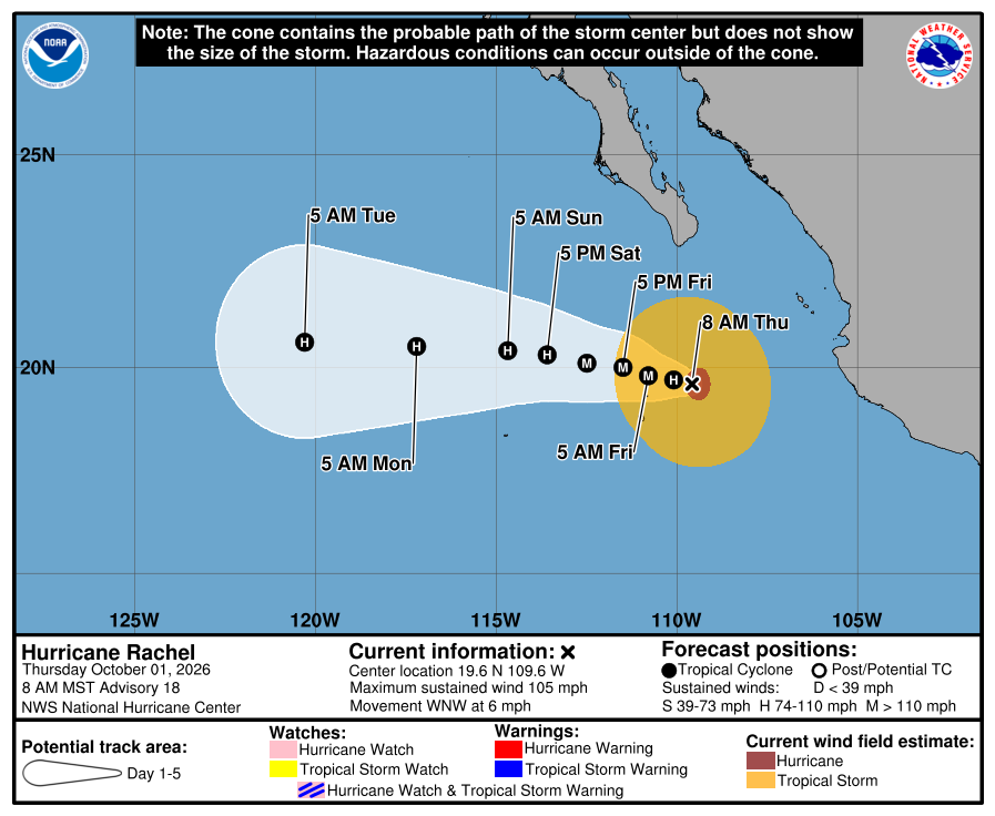
Figure 6. The official track for Rachel issued Thursday at 8 a.m. MDT on October 1, 2026. Rachel is forecast to reach 120 mph maximum sustained winds on Friday, Oct. 2, 2026, then gradually come down in strength throughout the weekend (Image credit: NHC)
Looking ahead to next week, another system could form by mid- to late-week south of southern Mexico. As of Thursday morning, the National Hurricane Center gives the disturbance a 70% chance of developing into a tropical cyclone. The next name on the eastern Pacific list is Simon.
Was Fay actually the Atlantic’s first hurricane of 2026?
For the first time since reliable satellite and hurricane-hunter data began in 1945, the Atlantic hurricane season ended September without a single hurricane. It was also the first time in more than 30 years, since 1994, that no hurricane was recorded during September.
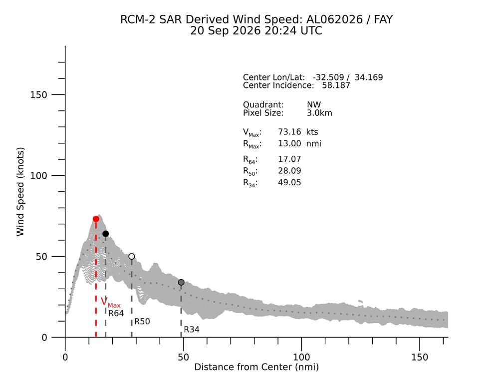
Figure 7. Wind profiler estimates from the Canadian Space Agency’s Synthetic Aperture Radar during a pass over Fay around 4:30 p.m. EDT Sep. 20, 2026. The satellite-derived wind profile shows wind estimates on the storm’s northwest side that suggest peak winds as high as 73 knots or 84 mph about 15 miles from its center. SAR wind estimates have historically run hot, but the information will be considered by NHC in its post-season assessment to determine whether Fay ultimately reached hurricane strength last week. (Credit: NOAA Center for Satellite Applications and Research, via Michael Lowry)
September did produce four named storms: Edouard, Fay, Gonzalo, and Hanna. Fay lasted longer than any of the others, peaking on Sept. 21 with winds of 70 mph (115 km/h), just shy of the 74-mph threshold for a hurricane.
However, the National Hurricane Center could upgrade Fay to a hurricane during its post-season analysis. A surface wind measurement from high-resolution Synthetic Aperture Radar (SAR) aboard a Canadian Space Agency satellite estimated winds on Fay’s northwest side at around 84 mph (135 km/h) at approximately 4:30 p.m. EDT on Sept. 20.
SAR measurements are known to have a high bias in their wind estimates, so this measurement alone does not establish that Fay became a hurricane. However, the National Hurricane Center can consider these data, along with other observations, during its post-season review to determine whether Fay briefly reached hurricane strength.

Irene Sans
Irene Sans is an Emmy-winning double-certified meteorologist by the American Meteorological Society (AMS, CBM, CDM) with almost 20 years of experience covering severe weather and climate stories across… More by Irene Sans

Bob Henson
Bob Henson is a meteorologist and journalist based in Boulder, Colorado. He has written on weather and climate for the National Center for Atmospheric Research, Weather Underground, and many freelance… More by Bob Henson

Jeff Masters, Ph.D., worked as a hurricane scientist with the NOAA Hurricane Hunters from 1986-1990. After a near-fatal flight into category 5 Hurricane Hugo, he left the Hurricane Hunters to pursue a… More by Jeff Masters
Jeff Masters
MORE LIKE THIS

After two landfalls in Mexico, Hurricane Polo’s rainmaking journey has just begun

Hurricane Nolo takes another turn, Polo to bring deep tropical moisture to Southwest desert

Hurricane Polo approaches Mexico as coastal storm grips Northeast, New England
Jeff Master’s and Bob Henson’s “Tropical moisture, stalled front fueling flood threat across the Central Plains” was first published on Yale Climate Connections, a program of the Yale School of the Environment, available at: http://yaleclimateconnections.org. This work is licensed under a Creative Commons Attribution-Noncommercial-No Derivative Works 2.5 license (CC BY-NC-ND 2.5).
Here are some “ETs” recorded from around the U.S. the last couple of days, their consequences, and some extreme temperature outlooks, as well as any extreme precipitation reports:
Here is More Climate News from Thursday:
(As usual, this will be a fluid post in which more information gets added during the day as it crosses my radar, crediting all who have put it on-line. Items will be archived on this site for posterity. In most instances click on the pictures of each tweet to see each article. The most noteworthy items will be listed first.)