The main purpose of this ongoing blog will be to track planetary extreme, or record temperatures related to climate change. Any reports I see of ETs will be listed below the main topic of the day. I’ll refer to extreme or record temperatures as ETs (not extraterrestrials).😉
Main Topic: Long Lasting Heatwave Develops Across Europe
Dear Diary. For well over a decade, I have not known a summer in which an ugly heatwave did not develop across Europe. The summer of 2025 is no different. This year’s rendition has started out with some records being set in Spain in late May and has spread northward through most of the European Union.
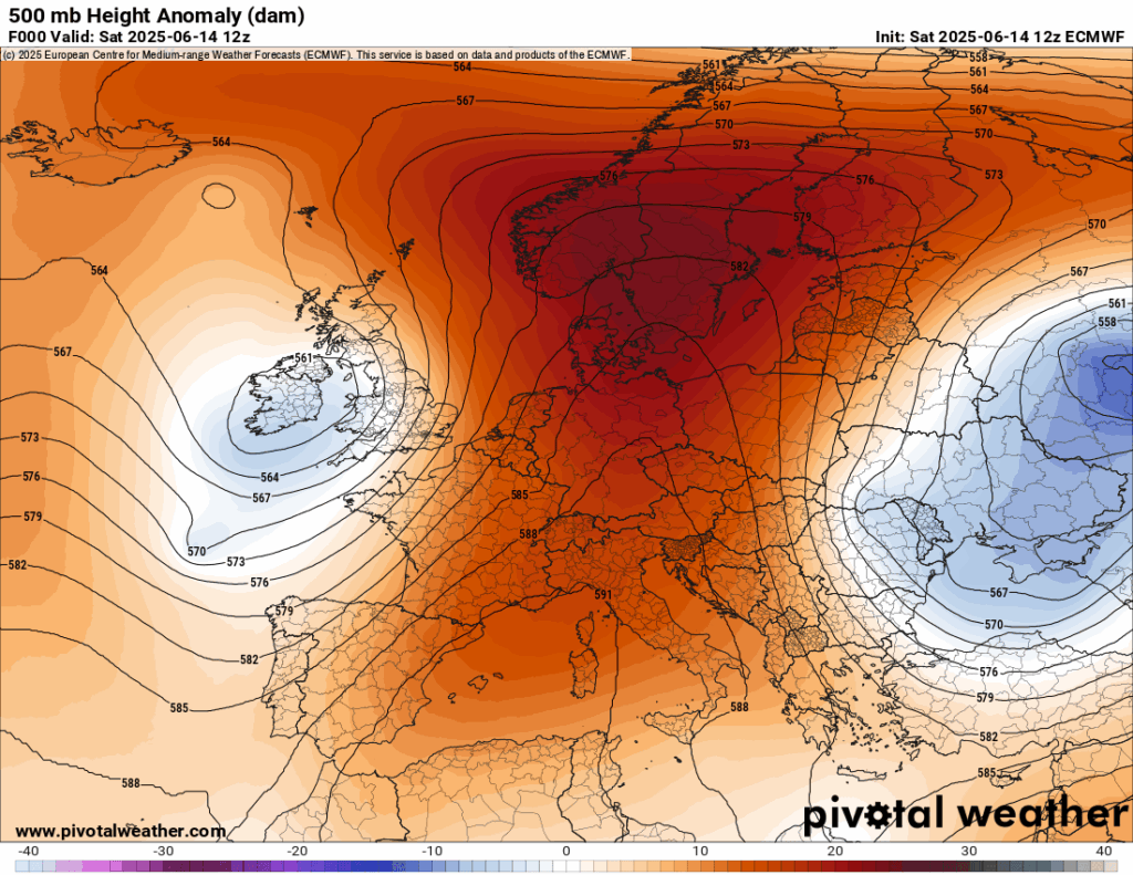
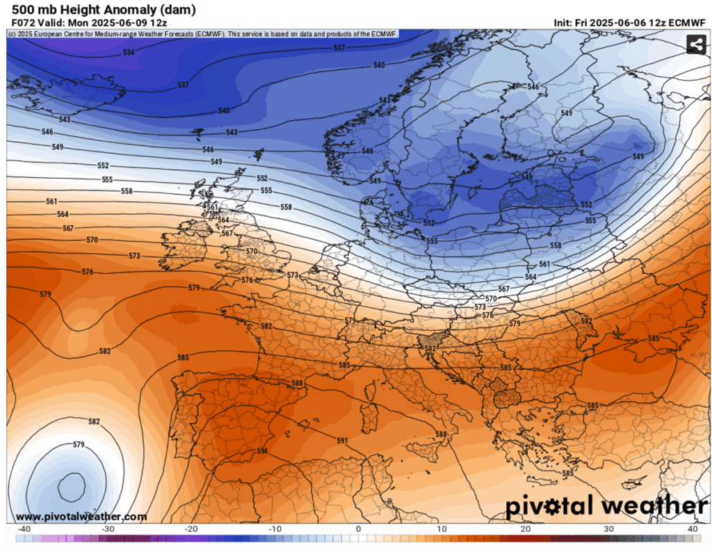
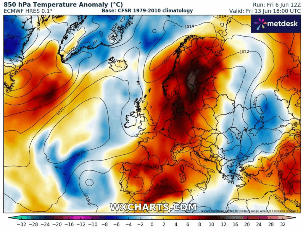
Here is what we had for a heat dome in association with the heat done this morning:
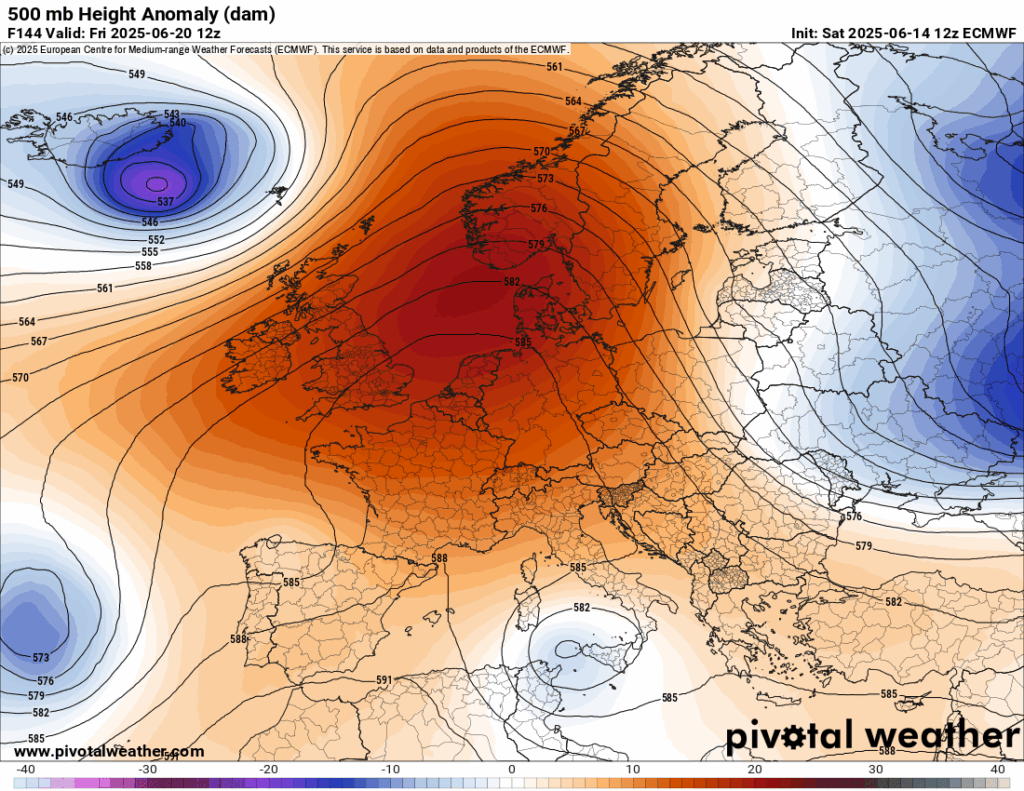
Only the British Isles remain cool under an upper low. The heat dome gets reoriented next week, but remains strong:
Here are some of the latest reports from Maximiliano Hererra from this heat episode:
This heatwave actually began last week. For a good perspective on that, here is an article from Severe Weather Europe:
https://www.severe-weather.eu/global-weather/first-heatwave-summer-2025-heat-dome-europe-mk
The first significant long-lasting heatwave develops in Europe through mid-June
By Author Marko Korosec
Posted on Published: 07/06/2025
Categories Global weather
June started with a dynamic weather pattern over most of Europe, influenced by an unusually persistent and intense low over the North Atlantic. As we head into the mid-June period, a more stable pattern emerges, leading to the first significant and potentially long-lasting heatwave in western and central Europe for the meteorological summer of 2025.
The final days of May were already marked by extremely high temperatures across southern Spain, with temperatures reaching nearly +42 °C on May 30th.
Heat first intensifies in southwestern Europe by Sunday, gradually expands into western Europe through mid-week, and then continues under a developing heat dome over northern and central Europe towards the following weekend.
Peak temperatures are forecast to surpass +40 °C across Iberia again, upper 30s in France, and mid-30s over central Europe and the Mediterranean.
This weekend, a large upper wave that was the primary trigger of the recent severe weather outbreaks in parts of Europe is gradually weakening as it moves from the west to northern Europe. A temporal refreshment is spreading into east-central Europe, while an upper ridge will begin developing into southwestern Europe through Monday.
It will continue to strengthen through mid-week, expanding northward into western Europe, reaching France, the Benelux countries, and the UK. Below is a quick overview of the developing heatwave, presented in the video animation.
The warm plume that spreads northward into western Europe will be a significant one, with a sharp temperature increase by mid-week, as seen in the animation above.
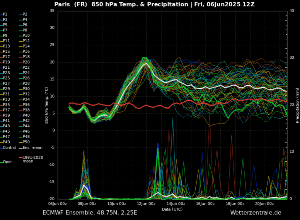
The following ECMWF model Meteogram for Paris (France) reveals how the 850 mbar (at around 1200m above sea level) temperature rises from around 5 °C on Monday to 20 °C on Wednesday. Thus, a more than 15 °C warmer air mass arrives with the vigorous warm plume.
And we can see that temperatures then remain above normal for an extended period.
So, the upcoming heatwave will be intense, and it occurs with the establishment of a heat dome aloft. Let’s examine what this large-scale feature is.
What is a Heat Dome?
When significant and historic record-breaking heatwaves occurred in Europe, the United States, and Canada in the past, the Heat Dome was a contributing factor. The heat dome is usually the dominant feature of summer weather patterns on both continents.
When extremely high temperatures develop, we refer to this phenomenon as a heat dome. Here’s how it works and why understanding it on a broader scale is essential.
The upper-level ridge pattern, or very warm air mass in the higher altitudes, also known as the Upper High (or blocking High), usually forms the heat dome. This weather pattern brings very high and sometimes record-breaking temperatures to the region underneath.

This term is used when a broad area of high-pressure air parks over a large portion of the continent. If the event is remarkably stable and extreme, it usually lasts several days or weeks.
The heat dome works like a lid on a pot. The extensive dome traps warm air at all levels underneath, with layers sinking toward the ground. Therefore, the air mass becomes anomalously warm at the lowest elevations and extremely hot near the surface.
The upper ridge develops a significant heatwave in southwestern Europe on Sunday and Monday
An upper low situated over the Azores over the weekend triggers a warm plume from northwest Africa towards the Mediterranean and the Iberian Peninsula as we head into the second week of June. In response to it, a heat dome builds up and expands north-northeast in the following days.
This pushes temperatures significantly higher across Spain and Portugal on Sunday, with mid-levels forecasted to be around 10-12 °C above normal.
As we can see on the following chart, the remaining refreshment across central, eastern, and northern Europe gradually weakens as the upper wave finally vanishes early this week. At the same time, the contrast with the much higher temperatures building up in southwestern Europe is quite apparent.
Very high temperatures will first develop across southern Spain and Portugal, with local peaks of around +42 °C on Sunday and 40 °C on Monday and Tuesday.
The highest values are, as usual during a heatwave over Iberia, forecast across the Andalusia region. The large valleys with dry climate are prone to extreme temperatures in the summer months in the area.
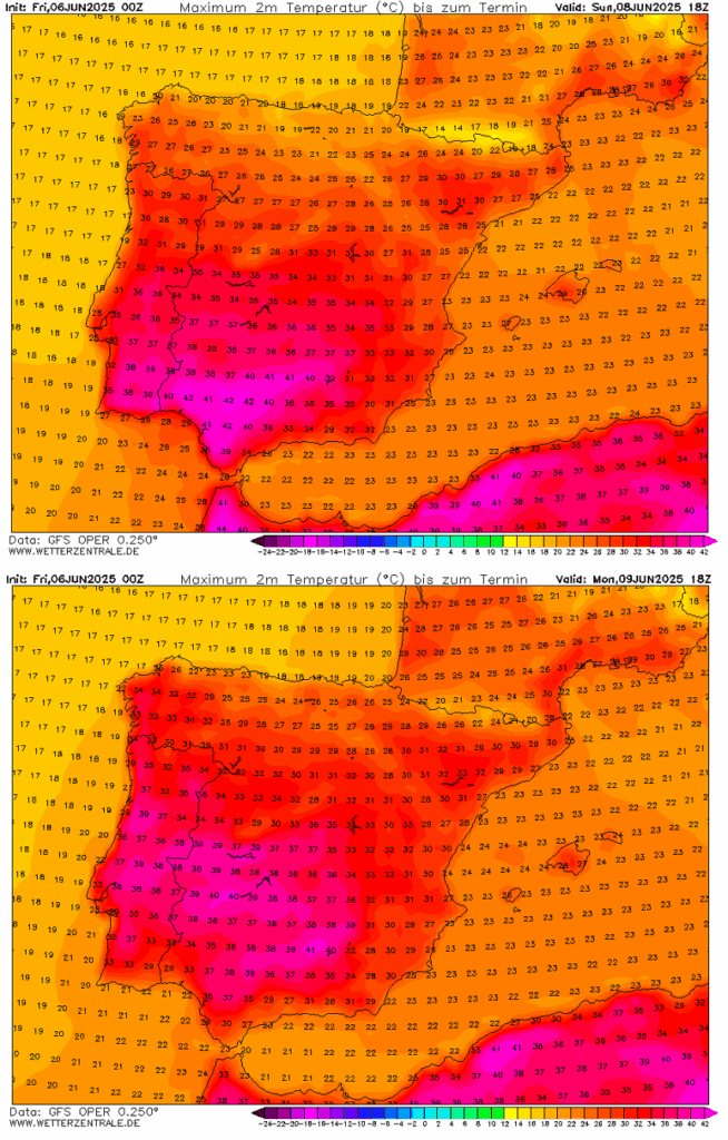
The peak temperature in southern and central Portugal will also reach the upper 30s and may touch the 40 °C mark as well, especially on Sunday in the south.
Monday’s temperatures will be the highest across central Portugal and Spain, as the upper ridge aloft shifts its core further north, in response to the heat dome expanding into France and western Europe through mid-week.
Heat Dome strengthens the heatwave into western Europe by mid-week
Through mid-week days, the upper ridge continues strengthening into western and central Europe, gradually taking over the pattern over the continent. This leads to a dominant blocking High and surface high-pressure for much of Europe throughout mid-June.
On Wednesday, the heat dome with the upper ridge is situated over western Europe, resulting in significantly higher temperatures developing across France, the Benelux region, and the UK, as well as gradually spreading into central Europe, Italy, and Germany.
Meanwhile, a shallow upper wave enters Iberia from the west and brings refreshment for the region. As we see, the so-called Omega blocking pattern has been established. This typically means a longer-lasting heatwave is on the menu.
Note: The Omega blocking pattern is typically the weather pattern that develops a heat dome. The strong ridge in the middle is surrounded by an upper low/wave on each side; one on the west side and another on the east side of the Omega core.
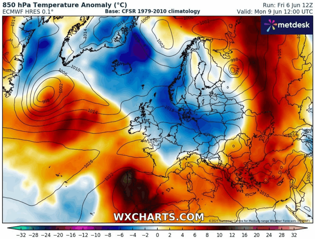
The 850mbar temperature anomaly hints at how significantly anomalous temperatures will be in western Europe on Wednesday, around 15 °C above normal for mid-June.
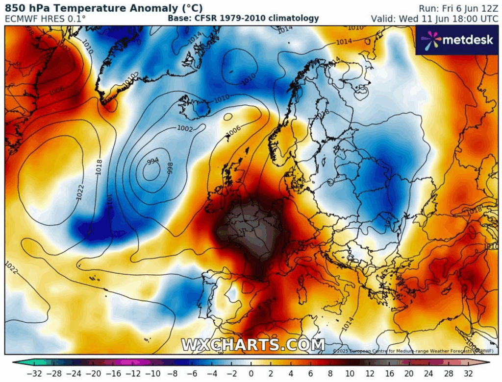
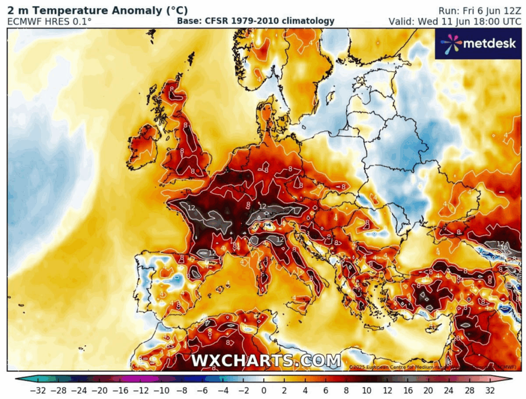
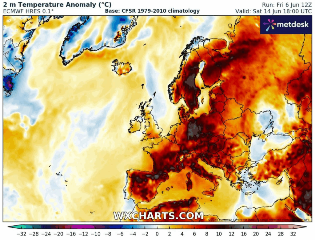
These strongly anomalous temperatures will translate towards the surface. Therefore, the 2m temperature forecast will also be 8-12 °C above normal.
Those will be the most anomalous over France, Benelux, Germany, the Alps, and Italy through mid-week.
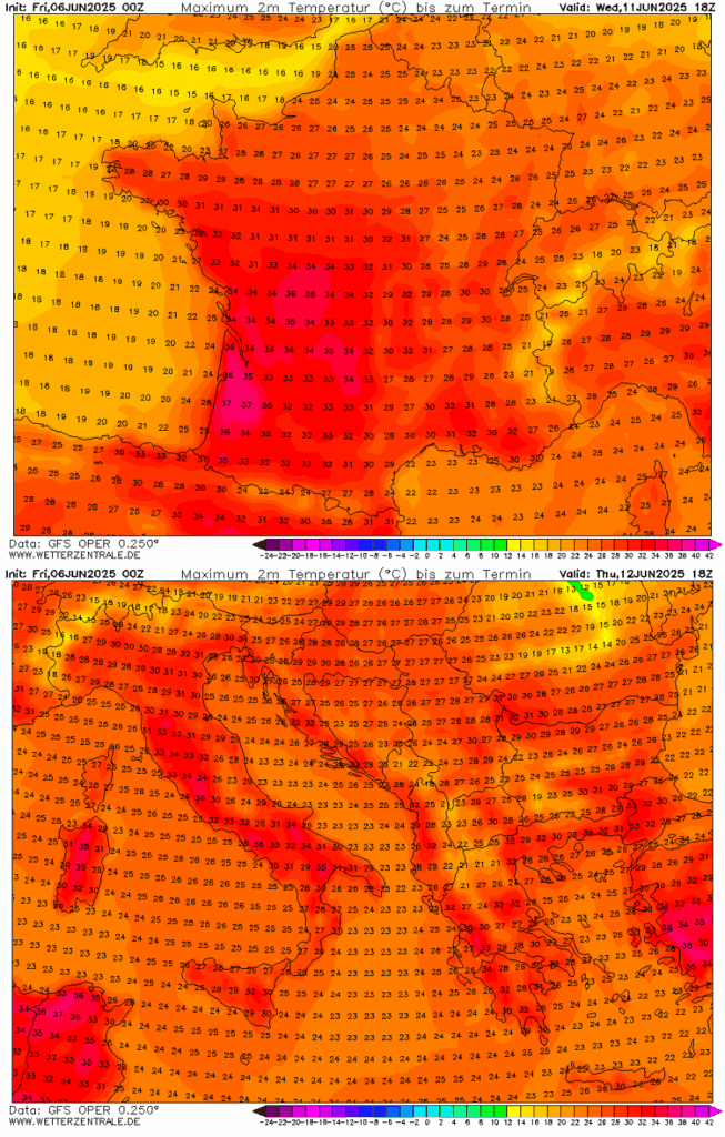
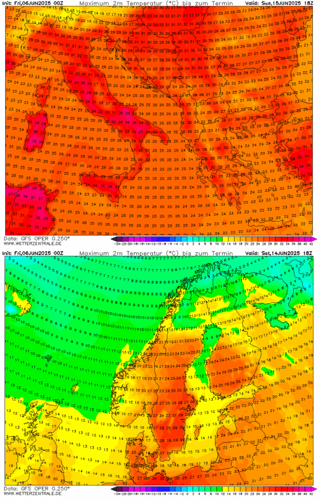
The peak 2m temperatures on Wednesday are expected to reach up to 38 °C in the southwestern parts of France, the low 30s across the south and northwest, and cooler towards the Benelux region. While on Thursday, it will be a few degrees higher in the north.
Thursday will also bring much higher temperatures across Italy and central Europe, which are expected to be the highest so far this summer. Peak temperatures are forecasted to be in the mid-30s in many areas.
This will establish a long-lasting heatwave for the region.
Heatwave expands into central Europe and establishes a long period of excessive heat; warmth develops over Scandinavia
Even higher temperatures are forecast for Friday and the following weekend across central Europe, Italy, and parts of the Balkan Peninsula as the heat dome and blocking ridge aloft peak over the northern and central parts of the European continent.
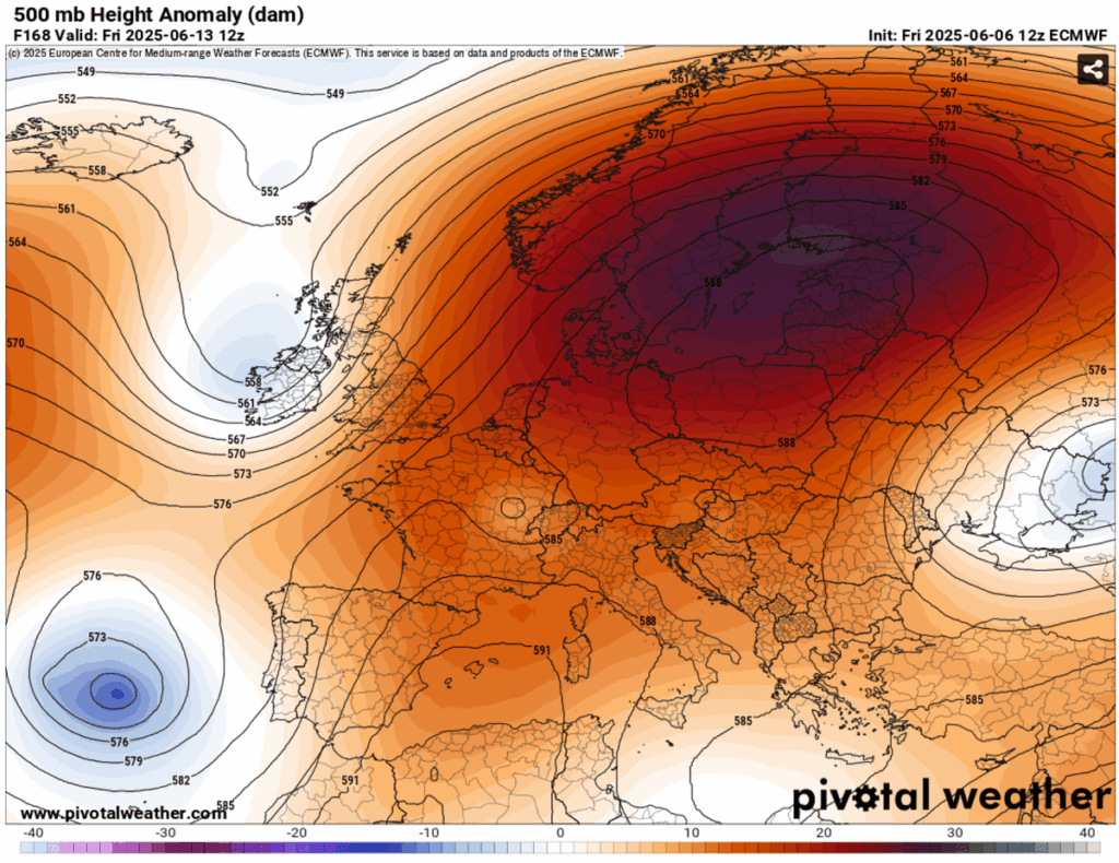
The expansive ridge extends into the mid-levels, becoming much warmer, and eventually also into the northern parts of Europe, which have been lacking significant warmth in recent weeks.
Temperatures over Scandinavia are expected to be 8-12 °C above normal from Friday through Sunday of next weekend.
The following 2m temperature for Saturday indicates how anomalous temperatures will be under the Omega blocking High, with much above normal temperatures across the middle of the continent.
About 10-15 °C warmer near surface temperatures from the Mediterranean across central Europe to Scandinavia.
Over central Europe, temperatures are likely to remain around 35 °C for a couple of days from Friday onwards and will locally exceed this mark. This will also be supported by a much drier air mass gradually developing, with no additional rain forecast in the regions affected as well.
Heat will also, albeit only for a short period, develop over Sweden on Saturday. Peak temperatures could reach the 30 °C mark in the afternoon hours.
Parts of the central Mediterranean are also likely to push into the upper 30s late this week.
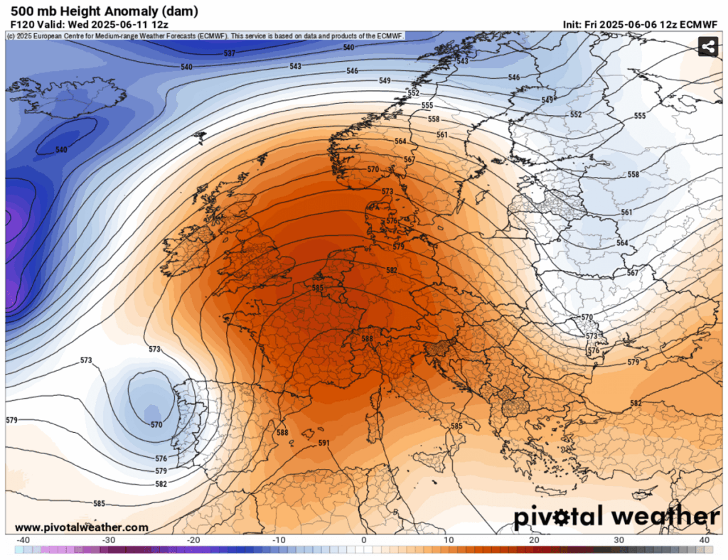
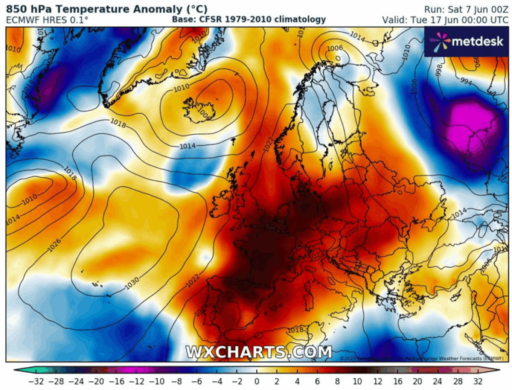
Following the weekend, the general trends in global weather models indicate some uncertainties regarding the persistence of the heat dome. The upcoming heatwave may persist into the week after. At the same time, some model variants predict a return to a more dynamic weather pattern with periods of rain and severe weather.
This is the latest forecast from the ECMWF global model: a heatwave is forecast to persist into the next week, bringing more stable and excessively hot weather across a large part of Europe.
We will continue to monitor the evolution of the weather pattern and update the forecasts accordingly. Stay tuned.
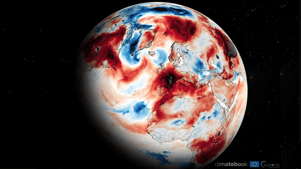
Pivotalweather, ClimateBook, Wxcharts, and Wetterzentrale provided images used in this article.
See also:
Heat Dome: Understanding the patterns that lead to extreme heatwaves
Here are more “ET’s” recorded from around the planet the last couple of days, their consequences, and some extreme temperature outlooks, as well as any extreme precipitation reports:
Here is More Climate News from Saturday:
(As usual, this will be a fluid post in which more information gets added during the day as it crosses my radar, crediting all who have put it on-line. Items will be archived on this site for posterity. In most instances click on the pictures of each tweet to see each article. The most noteworthy items will be listed first.)