The main purpose of this ongoing blog will be to track planetary extreme, or record temperatures related to climate change. Any reports I see of ETs will be listed below the main topic of the day. I’ll refer to extreme or record temperatures as ETs (not extraterrestrials).😉
Main Topic: More Flooding for U.S.- New Jersey and New York Get Hit Hard
Dear Diary. Like many other parts of the world the United States is being hit hard by climate changed influenced weather this summer…and it’s been a long summer of tragedy as we mark its meteorological halfway point on July 15th. The Texas flooding marks the worst weather event of the season so far, and God forbid it is just a taste of things to come because the tropics have yet to get cranking.
July 2025 has been the month of the flood and not just in Texas. Portions of the Northeast got walloped yesterday. In New Jersey there were two fatalities reported so far. Of course, flooding has been part of the natural world as long as water has been on this planet, but we are seeing higher incidents of it with heavier amounts of rain due to climate change. Warmer air due to climate change holds more moisture, and when weather systems interact with near saturated air masses, we get historic flooding.
Here is a new Washington Post article describing what happened in New Jersey and New York that had serious flooding on Monday:
https://www.washingtonpost.com/weather/2025/07/15/new-jersey-flooding-nyc-northeast
New Jersey and New York City battered by heavy rain and flash floods
A state of emergency has been declared in New Jersey, while New York subway stations were flooded. Flash flood warnings were issued in Pennsylvania and Virginia.
July 15, 2025
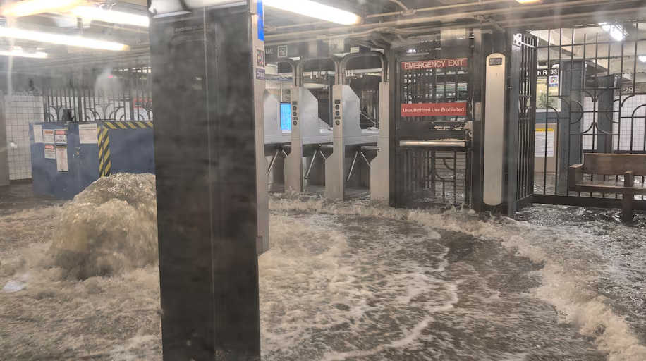
A flooded subway station in New York City on Monday. (Juan Luis Landaeta/Reuters)
By Andrew Jeong, Ben Noll and Victoria Craw
Intense flooding and heavy rain has swept across parts of the Northeast, prompting New Jersey Gov. Phil Murphy (D) to declare a state of emergency and causing severe delays and suspensions on New York City’s subways. Early Tuesday morning travel services in New York City and New Jersey appeared mainly restored, with some travel disruption expected to persist.
The flooding necessitated rescues, grounded planes and submerged vehicles in waist-high water less than two weeks after flash floods in Texas killed more than 100 people, triggering concerns about the increasing number of flood fatalitiesin recent years because of heavier rainfall, fueled in part by climate change.
What to know
- There were at least 216 reports of flooding across the United States on Monday, with the highest numbers in New York, New Jersey and Pennsylvania. The overall pattern is consistent with what has been observed countrywide this month, fueled in part by unusually warm Atlantic Ocean waters.
- A plume of tropical moisture was surging up the Eastern Seaboard, connected to a developing tropical storm near Florida. Storms from the Mid-Atlantic to the Northeast harnessed this moisture, producing flash flooding.
- More storms are forecast on Tuesday, though they are not expected to be as intense or widespread, with another surge of heavy, potentially flooding storms possible in the region from Wednesday to Friday.
Radar estimates show more than 6 inches of rain fell in a matter of hours in northern New Jersey.
Newark Liberty International Airport reported groundings, delays and disruptions to flights, as New Jersey officials warned residents to avoid unnecessary travel. Travelers were urged to check with their airline to determine the status of their flight due to disruptions early Tuesday. Rail services appeared to have returned to normal after “severe impacts” due to weather, New Jersey Transit said.
Buses were also delayed — videos on social media showed submerged cars that were caught by the abrupt floods, including those on the New Jersey Turnpike.
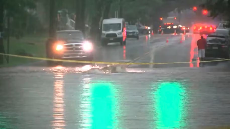
This image made from video shows a flooded street in Rahway, New Jersey, on Monday. (WABC/AP)
Shawn LaTourette, the head of New Jersey’s Department of Environmental Protection, said in a social media post that about a sixth of the state lies in a floodplain, and he told residents to take flood warnings seriously.
Affected areas in the stateincluded Union County, Essex County and Somerset County. A house in North Plainfield, New Jersey, was completely destroyed and appeared to have exploded after floodwaters swept through the area, according to local media reports.
CBS News shared video of a rescue being carried out in Scotch Plains, New Jersey, where a man was pulled by a rope through floodwaters, according to the news outlet.
New York subways flooded, trains disrupted
New York City experienced its second-highest hourly rainfall since 1943 — receiving 2 inches in 30 minutes — and considerable flooding. Train services were disrupted, subways were flooded in “multiple stations,”the NYCT subway service said, and roads were inundated, though precipitation was expected to weaken into Tuesday morning.
The rainfall was expected to continue moving east and become less intense into early Tuesday, with residents urged to take heed of road closures due to the risk of residual flooding, NWS New York said.
Earlier, a flash flood warning was issued for all five borough’s according to New York City’s Emergency Management Department, citing National Weather Service warnings.
People were warned to be ready to move to higher ground as “streets, basements, and below-grade spaces can fill with water in minutes,” the agency said on X. “If you live in a basement apartment or low-lying area, be ready to move to higher ground. Keep your Go Bag near the door and clear exit paths.”

A man looks on from a subway as a station is flooded in New York. (Juan Luis Landaeta/Reuters)
In Westchester County a flash flood warning was issued by the local Department of Emergency Services (DES) with residents urged to stay off the roads until conditions improved.
Westchester County Executive Kenneth W. Jenkins told CBS News parts of the area were “underwater” with Saw Mill River Parkway, Bronx River Parkway and Sprain Brook Parkway all affected. Some drivers had to be rescued by local emergency services as “the water came up very, very quickly,” he said.
New York Gov. Kathy Hochul (D) also said on social media there was flash flooding in the Hudson Valley with serious conditions and several rescues in Rockland and Westchester.
Flooding reported in eastern Pennsylvania
In Pennsylvania, the NWS issued a flash flood warning for the cities of Allentown, Bethlehem, Easton and Philadelphia, among other areas. The counties of Adams, Cumberland, Dauphin, Franklin, Lancaster, Lebanon, Perry, Schuylkill and York were under a flood watch earlier Monday.
The state’s Emergency Management Agency said it was seeing flooding across the state’s east and urged people to charge devices, listen to local forecasts and never seek higher ground in an attic that had no means of escape. People were also urged to avoid driving if possible, including over bridges which can wash away without warning, it said.
In the Mount Joy Borough in Lancaster County, a Declaration of Disaster Emergency was declared by the local council after more than 7 inches of rain fell in five hours, according to the Mount Joy Fire Department.
The fire department said it received reports of more than 5 feet of water in some homes and carried out 16 water rescues, with more than 30 requests for help due to flooded basements.
Flash flood warnings in Virginia
Overnight flash flood warnings were issued as far south as Petersburg, Virginia, where several water rescues were underway, according to the NWS. A warning was also in affect for areas including Colonial Heights and Emporia until early Tuesday morning, the agency said.
Authorities have urged drivers to stay off the roads in flood conditions due to the risk of being swept away. The NWS has said more deaths occur due to flooding than any other storm-related hazard, with just 6 inches of fast-moving water able to knock over an adult.
“It takes just 12 inches of rushing water to carry away most cars and just 2 feet of rushing water can carry away SUVs and trucks,” it said.
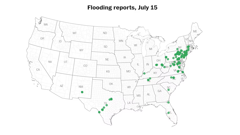
There were at least 216 reports of flooding across 16 states and D.C. on Monday. (Ben Noll/Data source: NOAA)
Extreme flooding events are on the rise
The number of flood deaths has ticked up in recent years, according to National Weather Service data. Across the country, 145 flood-related deaths were reported in 2024, The Washington Post reported, well above the 25-year average of 85 per year.
The intensity and frequency of extreme flooding events are on the rise across the United States and are likely to worsen in the years ahead, said Daniel Swain, a climate scientist at the University of California Agriculture and Natural Resources. Warming temperatures will allow more moisture to gather in the atmosphere, leading to more extreme downpours, he said.
“The climate today is very different from what it was a few decades ago,” Swain said. “And so, we are seeing an exceptional number of these events this summer.”
Swain pointed to tallies in New York City showing that the heavy rainfall events have tended to happen more frequently in the 21st century. According to hourly rainfall data from New York City gathered since 1943, the top four hours with the most rain occurred after 2020. Nine of the top 10 hours have occurred this century.
More extreme weather articles:
HAND CURATED
- There’s more flooding risk into next week, after week of deadly delugesJuly 11, 2025
- Some weather models predicted the Texas flood. Why did the official forecast miss it?July 9, 2025
- Trump’s NOAA pick stands by budget cuts, calls staffing ‘a top priority’July 9, 2025

By Andrew Jeong Andrew Jeong is a reporter for The Washington Post in its Seoul hub. follow on X@hj257

By Ben Noll Ben Noll is a meteorologist passionate about explaining the why behind the weather, extreme events and climate trends. He has expertise in data analysis, supercomputer-driven graphics and forecasting weather worldwide. follow on X@BenNollWeather
By Victoria CrawVictoria Craw is a breaking news reporter and editor in The Washington Post’s London Hub.
More:
Here are more “ET’s” recorded from around the planet the last couple of days, their consequences, and some extreme temperature outlooks, as well as any extreme precipitation reports:
Here is More Climate News from Tuesday:
(As usual, this will be a fluid post in which more information gets added during the day as it crosses my radar, crediting all who have put it on-line. Items will be archived on this site for posterity. In most instances click on the pictures of each tweet to see each article. The most noteworthy items will be listed first.)