The main purpose of this ongoing blog will be to track planetary extreme, or record temperatures related to climate change. Any reports I see of ETs will be listed below the main topic of the day. I’ll refer to extreme or record temperatures as ETs (not extraterrestrials).😜
Main Topic: Second Update on Hurricane Melissa
Dear Diary. As forecast and feared CAT5 Hurricane Melissa made landfall in western Jamaica this morning, and as of this writing is near the second most populous city and resort town of Montego Bay. Before making landfall, Melissa became the third most powerful hurricane to ever occur in the Atlantic Basin and the strongest to hit a landmass in the Atlantic Basin:
Like yesterday we will link news and notes from experts here:
Here is a good up to date summary of what occurred from the Washington Post:
Hurricane Melissa, still a Category 5, crosses western Jamaica after landfall
The storm tied for the strongest recorded landfall in the Atlantic basin.
October 28, 2025 at 2:22 p.m. EDT
Hurricane Melissa made landfall in southwestern Jamaica on Oct. 28 as a Category 5 storm. (Video: CSU/CIRA & NOAA)
By Livern Barrett, Sammy Westfall, Ruby Mellen and Ben Noll
KINGSTON, Jamaica — Hurricane Melissa made landfall Tuesday afternoon as a Category 5 storm — tying for the strongest hurricane landfall on record in the Atlantic basin.
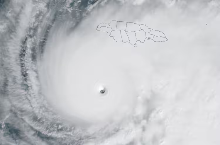
The storm came ashore in southwestern Jamaica with maximum sustained winds of 185 mph, the National Hurricane Center said. The storm’s eye struck in New Hope — roughly 75 miles west of the capital, Kingston. It was expected to cross the island over a period of six hours. About an hour later, with its maximum winds slightly weaker, the storm was crossing the western part of the island nation.
The storm’s central air pressure reached 892 millibars — a sign of incredible intensity — also making it the third-strongest Atlantic storm on record by this metric. Air pressure measures how much the atmosphere weighs above a given point — and in hurricanes, lower pressure means the air is rushing inward and upward with more force, driving stronger winds.
It is unusual for a storm to be at peak strength as it comes ashore.
It’s going to be “a very dangerous scenario now starting to play out” as the eye of Melissa moves across Jamaica, National Hurricane Center Director Michael Brennan said in an earlier Tuesday briefing. That is expected to include “total building failures” and “catastrophic wind damage” — with gusts up to 200 miles in places of higher topography.
As the weather began to deteriorate here earlier in the day, the storm’s peak intensity also surpassed that of Hurricane Katrina in 2005.
Colin Bogle, a Mercy Corps adviser, described the “crescendo of, like, anxiety building up within me” as the storm grew closer. “And the soundtrack of the hurricane is not in any way helping.” Bogle spoke from Portmore, a suburb just west of Kingston.
“It’s very nerve-racking,” Bogle told The Washington Post. “You hear the wind outside, and you hear the water outside. … You think to yourself, ‘What would I do if I just heard a crack, and my roof blew off?’”
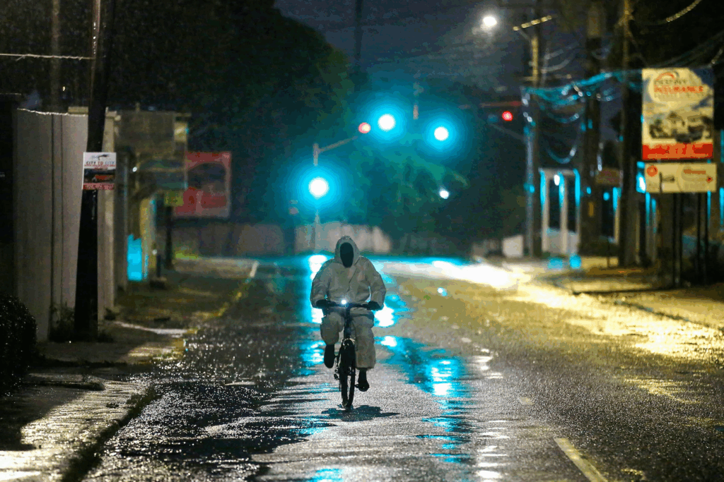
A man wearing a protective suit bikes in Kingston on Monday evening, as Hurricane Melissa approached. (Octavio Jones/Reuters)
Kingston’s business district, usually a hub of buzzing activity on weekday mornings, now looks deserted. Orange Street sees near-constant gridlock traffic, but Tuesday was near empty. Major buildings including the Jamaica Stock Exchange and the Bank of Jamaica were all shuttered.
Parking lots are empty, and police cars are among the few vehicles still driving, maintaining a strong presence, particularly in the business capital, to preserve order and prevent any chance of looting.
Christopher Tufton, Jamaica’s health minister, confirmed three deaths and 13 injuries across the country as of Monday, associated with people preparing for the storm. Most of the injuries happened as people fell off ladders and rooftops, and the deaths occurred as people were cutting down trees, he said.
By late Monday, around 133 of the 880 designated emergency shelters were open and housing displaced people.
Humanitarian relief groups have been busy making preparations for their response.
Pre-positioning humanitarian supplies has been key for the World Food Program, said Brian Bogart, the agency’s Caribbean country director. Access to move food and relief supplies to affected communities will be a massive challenge as infrastructure, transportation and logistics capacity are affected, he said, speaking from Kingston.
In neighboring Haiti, where the storm moved near its southern peninsula, Melissa has already inflicted damage. Haitian officials confirmed three weather-related fatalities last week, with 450 homes flooded and 10 others damaged. At least 3,653 people have been displaced and are currently sheltering in temporary accommodations.
Powerful winds and heavy rains swept through multiple municipalities, submerging roads in the hardest-hit areas and sustaining significant damage on the agricultural sector, which was already in crisis.
As international donors have pull back from Haiti, many humanitarian organizations have reported sharp reductions in funding, jeopardizing their ability to respond effectively in the hardest-hit areas. Normally, ahead of hurricane season, WFP would have around 3,000 metric tons of food stockpiled in Haiti — enough to feed 200,000 people for a month. But in the heavily affected southern region, only 450 metric tons are currently available.
“Our teams are on the ground and preparing to begin distributions, but this isn’t our usual level of readiness,” Tanya Birkbeck, a WFP spokesperson, told The Post.
As the storm closed in from the southern coast of Jamaica’s main island, the outlook remained grim. Jamaican Prime Minister Andrew Holness said he had “been on my knees in prayer,” and he gave a dire prediction of what might come: roofs sheared from homes, roads inundated, infrastructure destroyed.
“There is no infrastructure in the region that can withstand a Category 5,” he said. “There’s going to be damage if there is a Category 5.”
Hurricane Melissa hazardous wind forecast
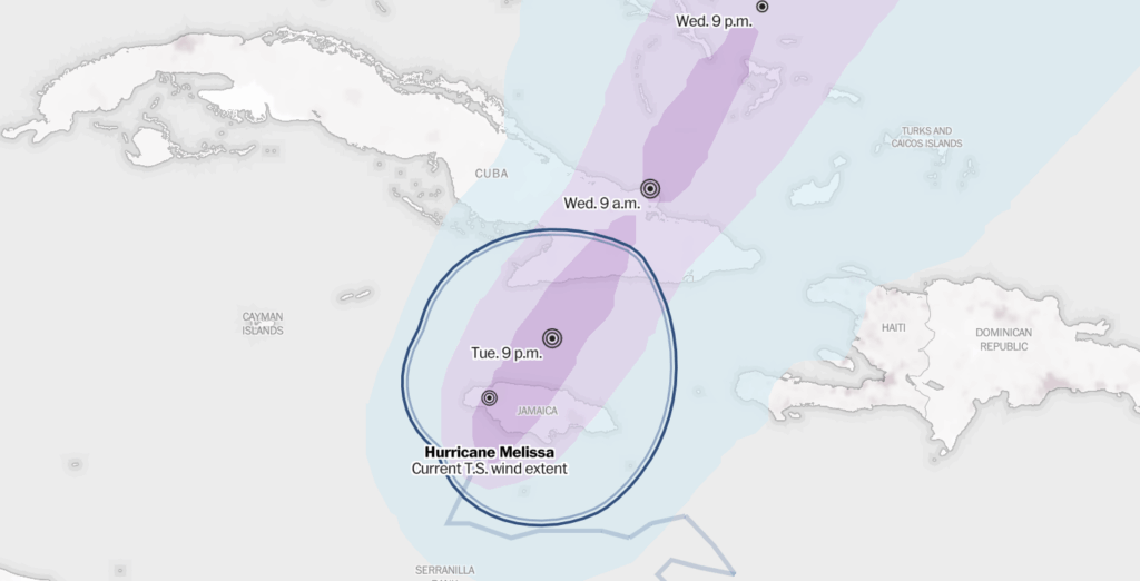
Sustained winds are at least 74 mph for hurricanes and 39 mph for tropical storms. All times Eastern. Source: National Weather Service (DYLAN MORIARTY, ADITYA JAIN, AND SZU YU CHEN/THE WASHINGTON POST)
Melissa fits a pattern of more-intense hurricanes in recent history compared with the past.
The predicted storm surge — up to 13 feet — poses a grave threat because most of Jamaica’s cities sit along the coast. The surge could also threaten Jamaica’s beachside resorts and undermine a tourism industry that accounts for about a third of its domestic economy.
“Remain sheltered!” the National Hurricane Center wrote early Tuesday. “Catastrophic flash flooding, landslides, and destructive winds will continue through today, causing widespread infrastructure damage. … Failure to act may result in serious injury or loss of life.”
Places such as Mandeville, Montego Bay, Negril, Black River and Alligator Pond could be among the hardest-hit.
“I’m thinking about my neighbors constantly,” Bogle said when the storm continued to close in overnight. “I’m wondering about people in my community who I know are vulnerable — how are they handling this kind of disaster?”
Category 5 Hurricane Melissa nears Jamaica on Oct. 28. Data source: NOAA. (Video: Ben Noll)
As Melissa intensified rapidly in warmer-than-usual Caribbean waters, Leanne Archer, a research associate in climate extremes at the University of Bristol, said the storm “could be the most devastating hurricane to ever hit Jamaica.”
“Hurricane Melissa is yet another stark reminder that islands such as Jamaica face the brunt of accelerating extremes amplified by climate change, despite being among those who are the least responsible for the problem,” she said.
The storm earlier Tuesday was measuring bigger than Hurricane Katrina, whose peak winds measured at 175 mph as it traveled through the Gulf of Mexico in August 2005, before making landfall as a Category 3 storm in Louisiana.
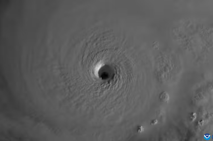
What it was like to fly into Hurricane Melissa’s eye
Melissa is one of the most powerful hurricanes ever. Here’s how it ranks.
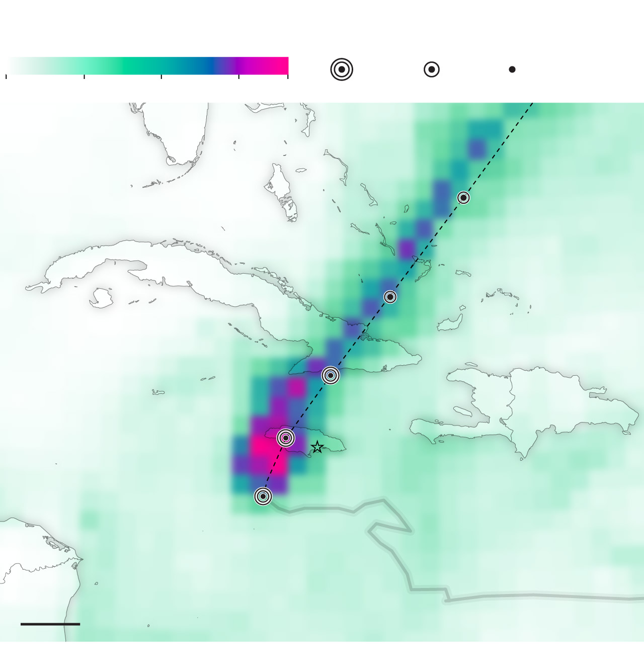
Rain is forecast to total up to 40 inches in the mountains, causing catastrophic flash flooding and landslides. Storm surge of 9 to 13 feet and huge waves are expected to inundate areas near the south coast around where the storm made landfall — with the highest risk in parishes such as Westmoreland, Saint Elizabeth, Manchester and Clarendon. Once the storm moves to the north side of the island and winds change, surge risks will shift into Saint James and Trelawny.
Cumulative rainfall forecast over the next three days
Data as of Monday at 6 p.m. Eastern Hurricane Melissa projected strength
Dangerous, hurricane-force winds are expected to cause blowing debris, debark and flatten trees, and snap power poles like twigs — especially within a 30- to 50-mile radius of the storm’s center. Jamaica’s main island measures 150 miles from west-to-east and 50 miles from south-to-north. Tropical-storm-force winds are expected across the entire island and hurricane-force winds in central and western parishes.
The most violent weather will occur in Melissa’s eyewall, carving a path across the west-central part of Jamaica’s main island.
After the north side of the eyewall rages through, an eerie silence will abruptly fill the air as the calm, 10-mile-wide eye arrives. Skies will briefly clear. But that tranquility doesn’t signal the end of the storm — it will be fleeting and marks only the halfway point.
After crossing Jamaica, Melissa is expected to weaken slightly, but it’s predicted to be a powerful Category 3 storm when it hits southeastern Cuba from Tuesday night into Wednesday. Hurricane warnings cover the Cuban provinces of Granma, Santiago de Cuba, Guantánamo and Holguin, while a tropical storm warning is in effect for Las Tunas. Rainfall of up to 25 inches, life-threatening landslides and 7 to 11 feet of storm surge will probably have devastating effects in some Cuban communities.
From Wednesday afternoon into early Thursday, the storm is expected to lash central and southeastern Bahamas — where Melissa may make its third landfall in fewer than three days — before it accelerates into the North Atlantic.
Up to 10 inches of rain and 4 to 6 feet of storm surge are predicted to hit the Bahamas, where hurricane warnings have been issued, particularly in the area from Great Exuma to Long Island, Crooked Island, Acklins Island and San Salvador. A tropical storm warning also covers the Turks and Caicos Islands.
But that won’t be the end of Melissa’s impacts.
The storm is forecast to pass near Bermuda early Friday, bringing strong winds, squally rain and dangerous seas.
The United States isn’t expected to be fully spared, either. Moisture from Melissa probably will fuel a separate storm tracking from the Mid-Atlantic to New England on Thursday and Friday, with a period of rain and wind expected in major Eastern cities.
When passing south and east of Atlantic Canada, what’s left of Melissa is expected to be shredded by the jet stream in the North Atlantic over the weekend, finally ending the historic storm’s almost two-week journey.
No storms immediately loom after Melissa. The Atlantic hurricane officially ends after Nov. 30, after which chances of intense storms drop significantly.
Westfall and Mellen reported from Washington, and Noll from Auckland, New Zealand. Widlore Mérancourt, Chico Harlan in Rome and Ian Livingston in Washington contributed to this report.
Here are more “ET’s” recorded from around the planet the last couple of days, their consequences, and some extreme temperature outlooks, as well as any extreme precipitation reports:
Here is More Climate News from Tuesday:
(As usual, this will be a fluid post in which more information gets added during the day as it crosses my radar, crediting all who have put it on-line. Items will be archived on this site for posterity. In most instances click on the pictures of each tweet to see each article. The most noteworthy items will be listed first.)