The main purpose of this blog will be to track planetary extreme, or record temperatures related to climate change. Any reports I see of ETs will be listed below the main topic of the day. I’ll refer to extreme or record temperatures as ETs (not extraterrestrials).😜
Main Topic: Record Warmth from December Has Persisted into January for Most of the U.S.
Dear Diary. I estimate that thanks to climate change, December 2025 will be yet another top 5 record warmest Decembers on record for the lower 48 states looking at reported record numbers from NCEI on my record scoreboard. We should know the results from them in a couple of days when I fill in the L48 Rank\Anom °F that is left blank in the lower right-hand corner of the following record scoreboard chart:
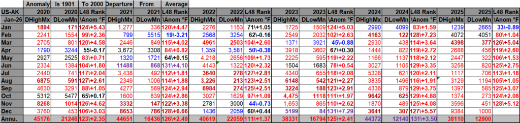
DHMX= Daily High Max Reports. DLMN= Daily Low Min Reports. DHMN= Daily High Min Reports. DLMX=Daily Low Max Reports.
Under tabs in each file: Boldly typed red-, blue- or purple-colored months, such as October 2024 and June 2021, that have ratios of >10 to 1 daily warm low records or <1 to 10 daily warm to low records are either historically hot or cold, most of which have made news. All NCEI rankings are for the lower 48 states with the warmest ranking since 1895 of average temperatures being 131 and 1 being the coldest as of 2025. Blue colors represent cold months and red warm. Those months and years with counts close to a 1 to 1 ratio of highs to lows are colored black. All-time record hot or cold months and years are colored purple. NCDC rankings have been color coded (under tabs in each file) such that values of 54 to 74 are black representing neutral months or years (+ or – 10 from the average ranking of 64). Totals are for the United States minus those from the state of Alaska to better get a representation of the number of lower 48 reports compared with lower 48 average temperature rankings.
That record warmth spilled over into the first ten days of the new year, but the very warm pattern is changing due to a jet stream trough developing in the East. Record warmth should continue in the West for most of this month since that area of the country will be under a heat dome:
My friend Bob Henson has written a summary of the record warmth that has been occurring across the country early this winter. I’m reposting it because as my readers know, this the Extreme Temperature Diary:
Still plenty of mildness – for now – after a historic holiday warm wave » Yale Climate Connections
Still plenty of mildness – for now – after a historic holiday warm wave
Much of the Southern and Western U.S. entered 2026 with weirdly nice conditions, but winter may yet strike a few more blows.

by Bob Henson
January 7, 2026
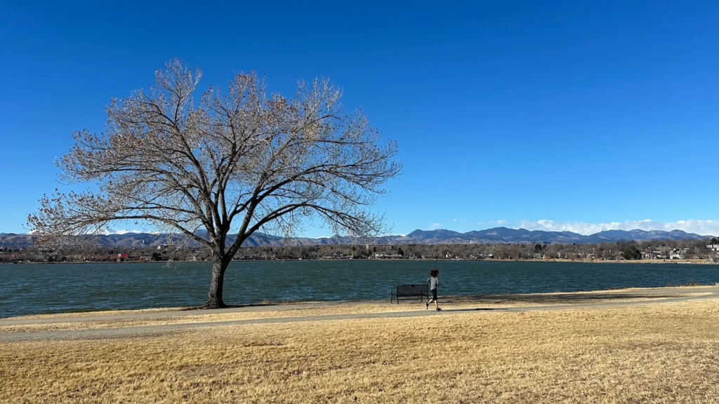
A runner makes their way across Sloan’s Lake Park in Denver against a backdrop of snowless foothills on January 6, 2026. Denver’s season-to-date snowfall of 6.8 inches through January 6 was the fifth lowest in 144 years of data. Only a single light snow is predicted through at least mid-January. (Image credit: Bob Henson)
From Phoenix to Denver to Houston, it was anything but a White Christmas. Tens of millions of Americans experienced the warmest holiday-straddling fortnight in more than a century of record-keeping, even as pulses of more seasonable cold and snow swept through parts of the Midwest and Northeast. The large-scale mildness seemed to be on cruise control during the first full week of 2026, yet some big realignments may allow for more truly wintry weather by late January.
Across the broad holiday stretch from Saturday, December 20, through Sunday, January 4, temperatures were the warmest on record for many locations across the Western and Central U.S., often by margins of three to five degrees Fahrenheit beyond the next-warmest year — which is quite a feat for a 16-day period. Here are a few examples — including four of the nation’s 10 largest cities — shown with their average for the period (in °F) and the starting year of the period of record-keeping, or POR:
Cheyenne, Wyoming: 42 (POR 1873-)
Wichita, Kansas: 44.5 (POR 1889-)
Salt Lake City, Utah: 44.7 (POR 1875-)
Denver, Colorado: 45.4 (POR 1872-)
Albuquerque, New Mexico: 48.3 (POR 1892-); margin 3.8°F
Amarillo, Texas: 51.8 (POR 1892-); margin 5.2°F
Oklahoma City, Oklahoma: 52.7 (POR 1891-); margin 3.9°F
Lubbock, Texas: 55.3 (POR 1911-); margin 5.0°F
Dallas-Fort Worth, Texas: 60.6 (POR 1899-); margin 3.3°F
San Antonio, Texas: 64.8 (POR 1886-)
Houston, Texas: 66.1 (POR 1982-)
Phoenix, Arizona: 64.4 (POR 1896-)
Out of hundreds of startling individual records during this span — such as 84°F in Oklahoma City on December 27, when the normal high is 48°F — perhaps the most eye-popping emerged from Salt Lake City three days before Christmas Day. As noted by meteorologist Alan Gerard on Substack, the city’s “low” temperature of 59°F on December 22 was not only the warmest daily minimum in Salt Lake City’s December history — it was warmer than the record high for that date of 57°F!
While many folks on holiday were donning T-shirts and shorts, skiers and snowboarders had to contend with anemic snowpack over much of the West, in part because unusual warmth has led to melting (and even rain at times) at distressingly high altitudes. Apart from the California Sierra and a strip from eastern Washington to western Wyoming, most of the West’s snowpack by year’s end was only about half of average — or less. In the doleful words of the website Powderchasers, “This winter is teaching the same blunt lesson across the country: precipitation only becomes ski season if the atmosphere is cold enough, long enough, at the elevations that matter.”
Meanwhile, Southern California got a holiday drenching, with a series of major Pacific storms delivering torrential rain, especially around and just north of the Los Angeles area. Across the 16-day period above, Santa Barbara notched 10.24 inches, its highest total for those dates in 85 years of record-keeping. The 7.17 inches in downtown Los Angeles was the city’s third-highest total for that span in data going back 139 years.
By early January, the moist, greening landscapes around L.A. couldn’t have offered a much more stark contrast to the bone-dry conditions that had fueled the catastrophic Palisades and Eaton fires just a year earlier.
Although a few thunderstorms had high rainfall rates, much of the SoCal rain fell in more moderate fashion, and that cut down on the flood risk, which had been newly exacerbated by the 2025 burn scars. (Western Washington and Oregon weren’t so fortunate just a couple of weeks earlier, as a prolonged, intense atmospheric river with unusually high snow levels led to record flooding and widespread landslides in early December.)
The California storms also brought generous snows to the state’s Sierra range after a paltry autumn. The state’s monthly survey on December 30 showed the critical Sierra snowpack had climbed to 71% of average. And California’s reservoir storage was up to 123% of the average to date, thanks in large part to three consecutive years of heavier-than-usual snowpack leading into this fall.
Much farther north, Alaska has been memorably wintry even by its own chilly standards. Over the 16-day holiday period, the capital city of Juneau received 52.2 inches of snow, demolishing the old record of 32.8 inches across 83 years of data, and the average temperature of 12.9°F was the fourth coldest on record for that period. The local Tlingit and Haida Indian Tribes issued a joint declaration of emergency on January 6, and the city of Juneau may shortly follow suit.
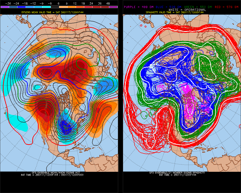
Looking ahead, long-range forecast models are hinting that a major rearrangement of this winter’s resilient pattern over North America could emerge by late January. Assuming that strong upper-level ridging pokes its way through western Canada and into Alaska in a couple of weeks, as suggested by some model ensemble members, that could open the door for frigid high pressure to surge southward toward the United States along the east side of the ridge. Some of the more intense midwinter U.S. cold waves of recent decades have followed similar playbooks, so it’s a prospect that bears watching.
La Niña may soon beat an unusually hasty retreat
This winter’s record southwestern warmth and the more typical northeastern chill align fairly well with what we’ve come to expect when La Niña comes to town. This periodic cooling of the eastern tropical Pacific Ocean often causes large-scale weather reverberations that last from northern fall into spring. During U.S. winters, La Niña events tend to sharpen the usual north-to-south temperature contrasts. This is much like what we’ve been seeing, albeit this time in a more northeast-to-southwest fashion, and with a warm skew to the entire picture (not a shocking outcome on a warming planet).
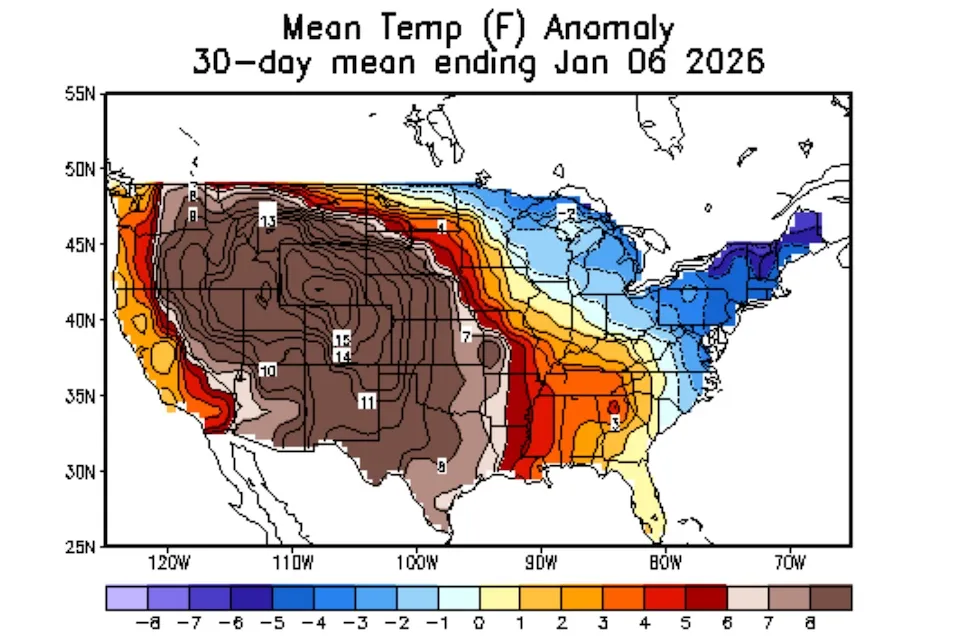
Figure 1. Temperature anomalies (departures from the 1991-2020 average, in degrees Fahrenheit) for the 30-day period ending on January 6, 2026. (Image credit: NOAA/NWS Climate Prediction Center.)
Weak La Niña conditions have prevailed for several months now, but they might segue with unusual speed into El Niño (the periodic warming of the eastern tropical Pacific). Already, temperatures averaged through the depth of the equatorial Pacific are running warmer than usual; eventually, the surface waters and the overlying atmosphere may warm as well.
The outlooks issued in December by NOAA and the International Research Institute for Science and Society implied that the balance will shift toward neutral conditions by spring and that El Niño might become likely by next fall, a common time for El Niño onset. However, there are already signs of the westerly wind bursts that can push across the Pacific tropics and help spur El Niño into action. In fact, two of the strongest El Niño events of the last half century, those of 1997-98 and 2023-24, were well underway by northern spring.
Headwinds and tailwinds from a broader long-term shift
Both El Niño and La Niña take shape within a longer-lasting atmospheric pattern called the Pacific Decadal Oscillation, or PDO. The PDO includes favored locations for atmospheric high and low pressure: the positive PDO fingerprint overlaps closely with El Niño conditions, and the negative PDO overlaps with La Niña. When the envelope of positive PDO conditions is in place, it tends to boost El Niño events and work against La Niña events; the converse is true of the negative PDO.
In one of the biggest and most vexing mysteries of climate science, the PDO has largely favored its negative mode for decades now. That’s made the eastern tropical Pacific one of the few oceanic areas of the globe that’s cooled rather than warmed. The pattern may also be feeding into the U.S. Southwest’s tendency toward drought since 2000, and several recent studies have linked this prolonged negative PDO trend to human-caused climate change.
Read: Why winter rains keep skipping the Southwest
There’s also a surge of research, including this just-published paper led by Clara Deser of the National Center for Atmospheric Research, indicating that a global-scale tropical ocean configuration that includes the eastern tropical Pacific cooling may have blunted the weather impacts of the otherwise potent 2023-24 El Niño.
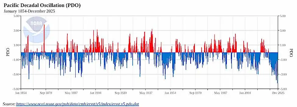
Figure 2. Trends in the monthly Pacific Decadal Oscillation from 1854 through 2025. (Image credit: NOAA/NCEI)
One thing we know for sure: the negative PDO hasn’t been going anywhere fast. In July 2025, the monthly PDO index dipped to -4.21. That’s the first value below -4 in a NOAA database that extends all the way back to 1854. And the PDO value for every single month since October 2019 has been negative. That’s the longest such continuous stretch in the entire 172-year record.
Jeff Masters contributed to this post.
Bob Henson’s “Still plenty of mildness – for now – after a historic holiday warm wave” was first published on Yale Climate Connections, a program of the Yale School of the Environment, available at: http://yaleclimateconnections.org. This work is licensed under a Creative Commons Attribution-Noncommercial-No Derivative Works 2.5 license (CC BY-NC-ND 2.5).
Here are some “ETs” recorded from around the planet the last couple of days, their consequences, and some extreme temperature outlooks, as well as any extreme precipitation reports:
Here is More Climate News from Sunday:
(As usual, this will be a fluid post in which more information gets added during the day as it crosses my radar, crediting all who have put it on-line. Items will be archived on this site for posterity. In most instances click on the pictures of each tweet to see each article. The most noteworthy items will be listed first.)