The main purpose of this ongoing blog will be to track planetary extreme, or record temperatures related to climate change. Any reports I see of ETs will be listed below the main topic of the day. I’ll refer to extreme or record temperatures as ETs (not extraterrestrials).😜
Main Topic: Strongest El Niño in a Century? What This Rare Phenomenon Could Bring.
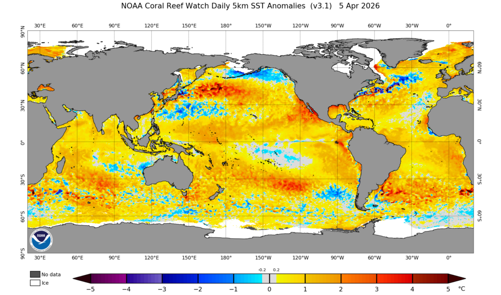
Dear Diary. Potentially we are about to see a phenomenon that will spike global temperatures to new heights never seen in human history, even more than those from the last decade. The last strong El Niño occurred in 2016. ENSO experts are forecasting a ‘super El Niño’ starting the second half of this year lasting through 2027. We already see the beginnings of an El Niño looking at warm sea surface temperature anomalies building off of the western South American coast:
This would mean that 2027 and potentially 2026 will be record warmest, surpassing the 2024 record in which an El Niño spiked global averages that year. A super strong El Niño combined with climate change will have some dire ramifications. The Washington Post has described these here:
Possible super El Niño could bring extreme heat, droughts, strong floods – The Washington Post
Strongest El Niño in a century? What this rare phenomenon could bring.
This year’s potential super El Niño is looking increasingly likely to have wide-reaching climate impacts that last into 2027.
April 6, 2026 at 9:41 a.m. EDT
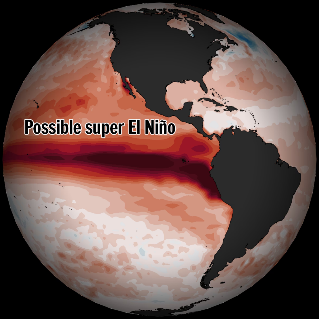
Dramatic ocean warming expected across the Pacific could lead to one of the strongest El Niño events on record this year. (Ben Noll/The Washington Post; data source: ECMWF)

By Ben Noll
The chances for a planet-warming super El Niño this year are rising, according to an updated model forecast issued Sunday.
The latest ECMWF outlook indicates there’s a high chance for a supercharged version of the climate pattern that affects regional-to-global weather patterns this summer or fall, doubling down on a super El Niño prediction from last month.
During a typical El Niño, a warming patch of water in the equatorial Pacific Ocean influences what regions experience droughts, floods, extreme heat, hurricanes and declining sea ice. During relatively rare super El Niño events, happening once every 10 to 15 years on average, the effects may be stronger, more persistent and more widespread.
That’s because sea temperatures in that key region of the Pacific Ocean warm more than 2 degrees Celsius (3.6 degrees Fahrenheit) above average, leading to a strong atmospheric response — typically peaking in December or January.
For example, the Western United States, parts of Africa, Europe and India could face a hotter-than-average summer, some tropical countries, such as those in the Caribbean and Indonesia could face worse drought and extreme heat, while more tropical cyclones could develop in the Pacific, with fewer in the Atlantic.
This possible super El Niño could also push global temperatures to record levels, particularly in 2027, and have agricultural impacts as weather patterns change.
“Real potential for the strongest El Niño event in 140 years,” wrote Paul Roundy, a professor of atmospheric science at the State University of New York at Albany.

A super El Niño event is forecast to develop by this fall, causing significant weather-related impacts across the planet. (Ben Noll/The Washington Post; data source: ECMWF)
Global impacts from a super El Niño
This year’s potential super El Niño seems increasingly likely to have wide-reaching climate impacts that last into 2027.
It could break the record for El Niño intensity set in December 2015, when sea temperatures in the central equatorial Pacific reached 2.8 degrees Celsius (5.04 degrees Fahrenheit) above average.
Still, even as some signs point to a potent event, including a rare triplet-cyclone pattern brewing in the Pacific, uncertainty remains as to how strong this year’s El Niño will become. Furthermore, no two El Niño events are alike — especially as the climate warms — but past experiences can be used to help plan and prepare.
Here are some of the weather impacts predicted to unfold through at least October, according to the newest model outlook.
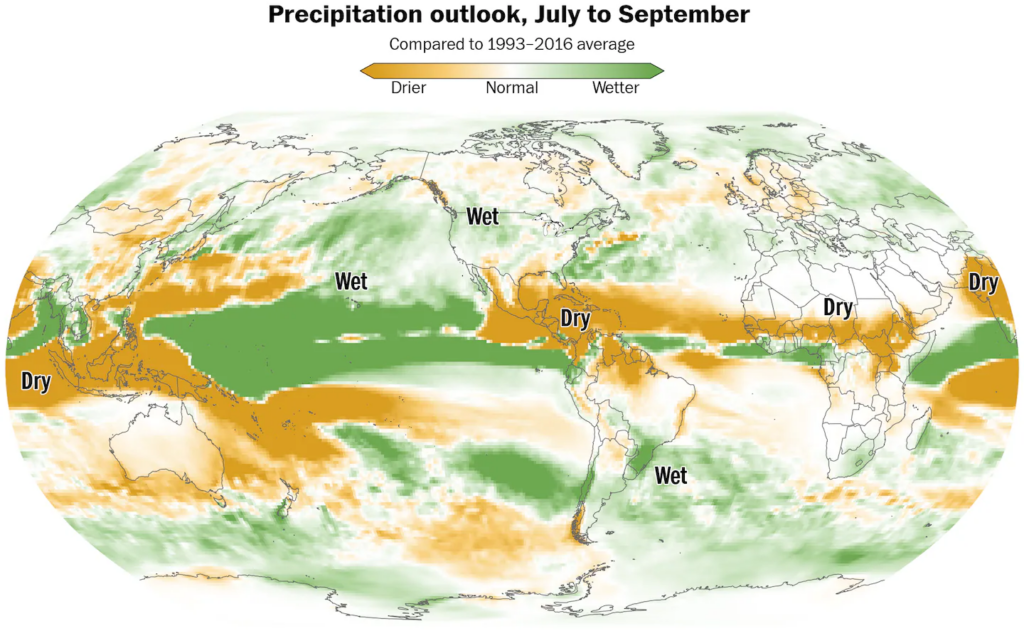
El Niño will influence areas of drought and downpours across the planet later this year. (Ben Noll/The Washington Post; data source: ECMWF)
- Reduced hurricane activity in the Atlantic Ocean and possible drought in the Caribbean islands. Increased hurricane and typhoon risk in the Pacific Ocean, including Hawaii, Guam and much of eastern Asia.
- Potential drought in central and northern India, suppressing rainfall from that region’s monsoon season, which could impact agricultural production.
- Above-average summer temperatures and humidity in the Western United States, possibly coming with unusual downpours, which may reach into the Plains and extend severe thunderstorm season.
- Developing droughts in portions of Central Africa, Australia, Indonesia, the Philippines, some South Pacific islands, Central America and northern Brazil, particularly later in the year. Flooding downpours in Peru and Ecuador, parts of northern and eastern Africa, the Middle East and near the equator in the Pacific.
- Higher frequency of heat waves across large parts of South America, the southern United States, Africa, Europe, parts of the Middle East, India and eventually Australia.
- New global temperature records — especially in 2027 — probably breaking records set in 2024.
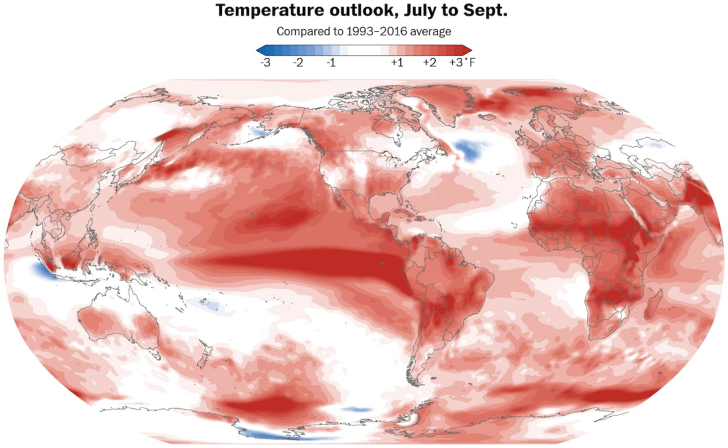
Well above-average temperatures are forecast across swaths of the planet later this year while El Niño is forecast to intensify. (Ben Noll/The Washington Post; data source: ECMWF)
The strongest El Niño events almost always cause a record-warm year. That’s because heat comes out of the ocean during El Niño, overspreads the tropics in the Pacific, then gets redistributed across the planet by changes in the jet streams.
This could contribute to milder winter temperatures in the United States — and big storms along the West Coast — as the impacts of El Niño reach a peak from the end of the year into early 2027.
As the planet warms, El Niño behaves differently
Strong El Niño periods often appear as an upward stairstep in long-term plots of global temperatures.
“Due to the increasing concentration of greenhouse gases, the climate system cannot effectively exhaust the heat released in a major El Niño event before the next El Niño comes along and pushes the baseline upward again,” Defense Department meteorologist Eric Webb said.
Therefore, a super El Niño in 2026-27 would disperse more heat than other events in 1982-83, 1997-98 and 2015-16.
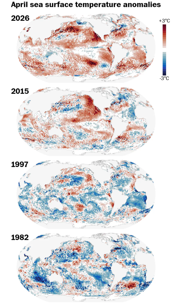
Sea surface temperature anomalies during the formative stages of four El Niño events show how much more warm water there is in 2026 compared to past years. (Ben Noll/The Washington Post; data source: NOAA/OISST)
Not only would a super El Niño spread unusual heat and humidity far and wide, but it may also spark record atmospheric moisture flows-, which drive downpours that raise the risk for floods. That’s because a warmer atmosphere has a higher moisture-carrying capacity.
By Ben Noll Ben Noll is a meteorologist passionate about explaining the why behind the weather, extreme events and climate trends. He has expertise in data analysis, supercomputer-driven graphics and forecasting weather worldwide.follow on X@BenNollWeather
More:
Here are some “ETs” recorded from around the U.S. the last couple of days, their consequences, and some extreme temperature outlooks, as well as any extreme precipitation reports:
Here is More Climate News from Monday:
(As usual, this will be a fluid post in which more information gets added during the day as it crosses my radar, crediting all who have put it on-line. Items will be archived on this site for posterity. In most instances click on the pictures of each tweet to see each article. The most noteworthy items will be listed first.)