The main purpose of this ongoing blog will be to track planetary extreme, or record temperatures related to climate change. Any reports I see of ETs will be listed below the main topic of the day. I’ll refer to extreme or record temperatures as ETs (not extraterrestrials).😜
Here is a new feature for this blog, which I will add daily. This is the latest inciteful Green News Report from my friends Desi Doyen and Brad Friedman at Progressive Voices. Hit ‘continue reading,’ listen, then hit return to see my daily topics:
Main Topic: Where CAT3 Heatwave Bluestone Will Set Record
Dear Diary. Welcome to July. Meteorological models suggest that July 2026 could be one of the hottest Julys in recorded history across the lower 48 states, so that will cause many health issues considering that July is the hottest time of the year anyway.
During early July going through the 4th of July weekend, we will be dealing with CAT3 Heatwave Bluestone, which may briefly become a historic CAT4 system should it break many all-time records. Today the Washington Post has come out with an article that forecasts when records will be broken at seven major cities. It also has forecasts for hundreds of more sites, which I did not repost. Click this link to get that information:
See the forecast for 7 cities that could soon see record-hot days and nights – The Washington Post
See which 7 cities could soon see record-hot days and nights
Parts of the Midwest had Dubai-like humidity on Tuesday. Here’s where that’s headed next.
July 1, 2026 at 6:14 a.m.

Tropical levels of humidity will spread from the Midwest to the East in the days ahead, contributing to elevated risks for heat-related impacts. (Ben Noll/The Washington Post; NOAA)

By Ben Noll
A heat dome was strengthening above the Ohio Valley early Wednesday, with more than 150 million Americans covered by heat alerts from the National Weather Service.
This sprawling area of hot air will soon move eastward and spend Thursday to Saturday squarely over the Mid-Atlantic, sending temperatures toward 105 degrees there, and breaking records from Florida to Maine.
Tropical levels of humidity will spread from the Midwest to the East in the days ahead, contributing to elevated risks for heat-related impacts. (Ben Noll/The Washington Post; NOAA)
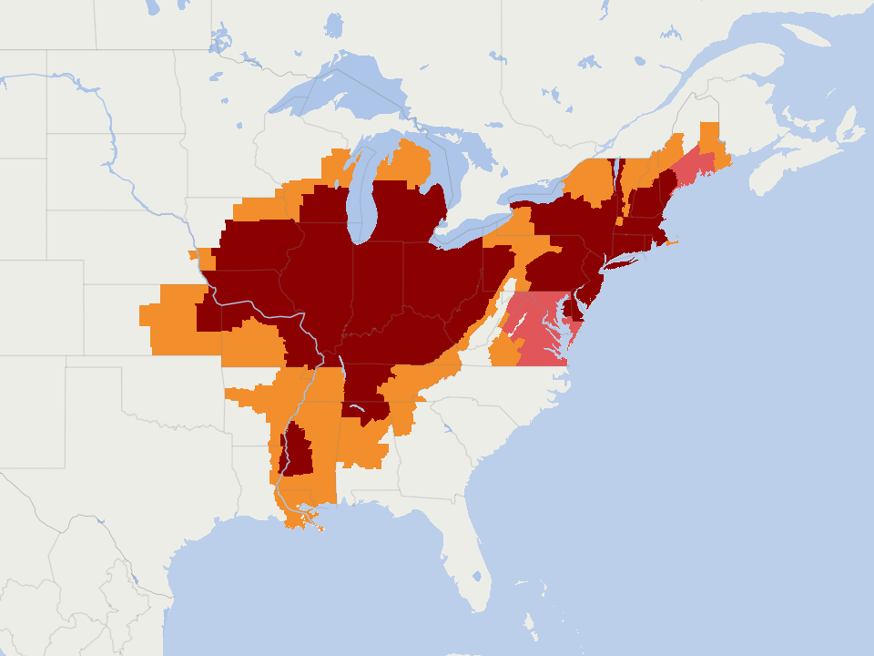
153 million Americans were covered by heat alerts from the National Weather Service as of 5 a.m. EDT on Wednesday
On Tuesday, parts of the Midwest experienced higher humidity than some of the world’s muggiest places.
Stretches of Illinois, Indiana, Iowa, Minnesota and Wisconsin experienced humidity that rivaled or even exceeded that of Dubai, a notoriously humid city on the Persian Gulf.
That’s according to the highest dew points, which measure how much moisture is in the air. Higher dew points make the air feel stickier and make it harder for sweat to evaporate, increasing the risk for heat-related impacts.
These high humidity levels are being fueled primarily by tropical air flowing north from the southwest Atlantic and eastern Pacific. Corn sweat may also be playing a supporting role, as growing corn plants release extra water vapor into the air across the Plains and Midwest.
Combining this humidity and heat, the nation’s highest heat index value on Tuesday was 113.6 degrees Fahrenheit at Scott Air Force Base in Illinois, about 20 miles east of St. Louis.
Similarly high — and dangerous — heat index values will build across the East from Wednesday through the weekend.

Around 65 million Americans are forecast to experience 100-degree heat through Monday. (Ben Noll/The Washington Post; ECMWF)
Here are forecasts for seven cities that will feel some of the worst of it in the days ahead.
Albany, New York
Peak of the heat: Wednesday to Saturday.
Very humid conditions will arrive in Albany on Wednesday and last through Saturday. On Thursday, the high temperature is forecast to near 100 degrees — possibly breaking the daily record of 98 degrees. Scattered showers and thunderstorms will probably bring some relief from high heat by Sunday.
New York City
Peak of the heat: Wednesday to Saturday.
It’s going to be a brutal stretch of heat and humidity for the Big Apple and surrounding areas into the weekend, with very little relief at night. The nearby city of Newark, New Jersey, is forecast to reach 105 degrees on Thursday, breaking a daily record. In New York City, a forecast low temperature of 84 degrees on Friday morning would match its average high temperature for the time of year — and tie for its warmest night on record.
Philadelphia
Peak of the heat: Wednesday to Sunday.
Three consecutive days of 100-degree heat are forecast in Philadelphia from Thursday to Saturday, with a peak of 105 degrees on Friday — which would become the city’s highest temperature on record. Increasing chances for showers and thunderstorms over the weekend, fueled by very high humidity, will probably cause the highest heat to subside by Monday.
Baltimore
Peak of the heat: Wednesday to Sunday.
There will probably be at least three consecutive days with 100-degree heat in Baltimore, peaking at 104 degrees on Friday, which would break a daily record downtown. The steam bath-like weather will continue at night, with low temperatures hovering near 80.
D.C.
Peak of the heat: Wednesday to Sunday.
The nation’s capital will experience some of its hottest days on record, when considering both the high and low temperature, from Thursday to Saturday. Forecast highs of 104 degrees on Thursday, 104 degrees on Friday and 101 degrees on Saturday would all break records, as would a forecast low temperature of 81 degrees on Friday morning and 82 degrees on Saturday morning. There’s a chance that Friday could become the hottest day since records began in 1871, considering the average of the high and low temperature — a mark that’s currently held by July 7, 2012, when the high was 105 degrees and the low was 82 degrees. Thunderstorm chances look to spike on Sunday, probably ushering in some relief by Monday. Ask The Post AIDive deeper
https://datawrapper.dwcdn.net/MpqfV
Richmond
Peak of the heat: Thursday to Monday.
Much of Virginia is in for a scorching stretch, including Richmond, where it’s forecast to reach or exceed 100 degrees for four consecutive days starting on Thursday — peaking at 102 on Saturday. That would equal the city’s longest such streak on record, set in 1953. Extreme heat will gradually fade as the chance for showers and thunderstorms increases starting Saturday.
Raleigh, North Carolina
Peak of the heat: Thursday to Tuesday.
This will be a pattern of high-end heat and humidity for the Carolinas, including Raleigh. That’s where there’s potential for five consecutive 100-degree days beginning on Thursday. The only other times such a long streak occurred there was in July 2011 (five consecutive 100-degree days) and July 2012 (six consecutive days). Because of extreme to locally exceptional drought, the ground can heat up quicker. Extreme heat is forecast to wane next week as shower and thunderstorm chances rise.Ask The Post AIDive deeper
By Ben Noll Ben Noll is a meteorologist passionate about explaining the why behind the weather, extreme events and climate trends. He has expertise in data analysis, supercomputer-driven graphics and forecasting weather worldwide. Follow on X@BenNollWeather
Here are some “ETs” recorded from around the U.S. the last couple of days, their consequences, and some extreme temperature outlooks, as well as any extreme precipitation reports:
Here is More Climate News from Wednesday:
(As usual, this will be a fluid post in which more information gets added during the day as it crosses my radar, crediting all who have put it on-line. Items will be archived on this site for posterity. In most instances click on the pictures of each tweet to see each article. The most noteworthy items will be listed first.)