Sunday May 12th … Dear Diary. The main purpose of this ongoing blog will be to track United States extreme or record temperatures related to climate change. Any reports I see of ETs will be listed below the main topic of the day. I’ll refer to extreme or record temperatures as ETs (not extraterrestrials).😉
When And Where The First Heat Dome Of The Summer Will Build Across The United States
Happy Mother’s Day one and all. Don’t forget to pamper that special person in your life. It is around Mother’s Day that the dreaded heat ridge starts to appear across some portion on the continental United States. Usually I define these as those greater than 588 decameters. Do I see any strong ones going into the second half of May, which potentially could pose life threatening conditions? Not really. I don’t see any strong signatures yet, but lately meteorological models have spit out some spurious forecasts such as this one from yesterday:
Yes I do have to laugh at any operational “fantasy” model panels that go out past 240 hours, the threshold period that most models can be reliable. Well, here is the same model (GFS) valid for the same time period today:

The big ridge is currently forecast to be over the Southwest two weeks from today, not the Southeast, and what about that Caribbean hurricane? That “phantomcane” is not forecast to exist. When looking at models going out more than a week it still pays to keep in mind past climatology. Hurricanes don’t form in the Atlantic Basin in May, and any 500 millibar heights above 594 decameters are quite rare. I’m not saying that the model forecast output from yesterday positively won’t verify at some point during a future May as global warming increases during the 21st century, just probably not this year.
If models can accurately get to the point forecasting when strong ridges will build after May 15th then many can be warned, including those in the agricultural or building sectors who can make adjustments given foreknowledge of coming hot conditions. We don’t have state of the art models that can accurately forecast strong ridges to build, though, more than two weeks out as of 2019.
So what do the models have for around 240 hours out, that threshold time in which current state of the art models can have at least some reliability? This week, not so much when comparing these operational panels:


In the last two panels we see that there is no agreement at all with the cold, blue short wave features. The European Model and American GFS hint at ridging occurring across about the southern quarter of the country, which usually happens from mid-late May, but there is no consensus as to exactly what state the ridge will be centered on nor the extent of the thing.
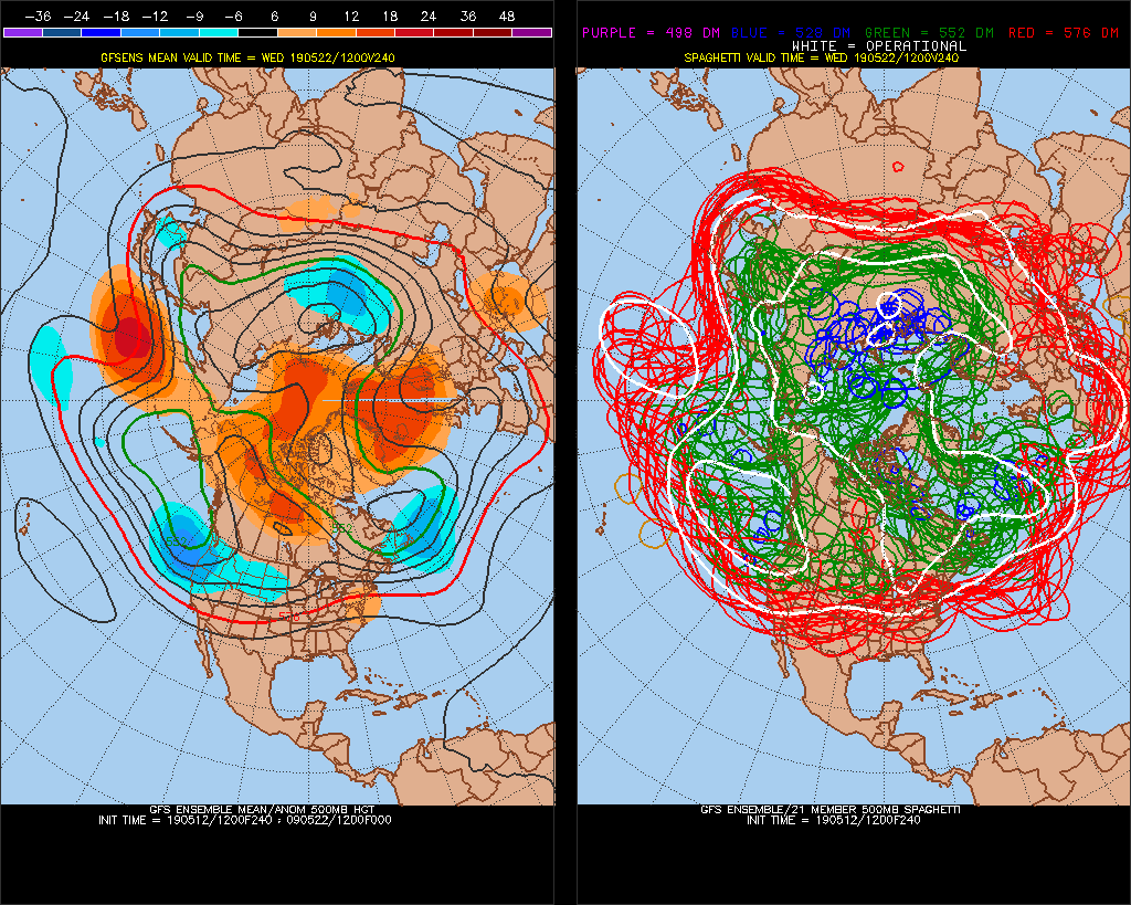
As I’ve pointed out many times in the past, when there is a lot of operational model disagreement its adviseable to use ensembles to get the best general forecast, especially going further out beyond a week. Here is what we see 240 hours out from the Penn State ensembles:

The white lines on the panel to the right represent the operational GFS model I showed in figure 2. We see lots of red and green “spaghetti” among model run members indicating that the GFS is having a lot of trouble establishing a consensus forecast valid at 240 hours out. The general pattern depicted on the left side of the chart is just a continuation of what we have seen from about mid April until now, that of a long wave trough remaining over the West with strong systems digging into the Southwest. These systems then eject into the Plains creating all sort of havoc ranging from tornadoes to heavy duty flooding. Here is an example of rainfall amounts from the current one moving across the Southeast:
Systems moving out of the Southwest have been strong enough to put the old kibosh on any heat trying to build northward from Mexico or across the Southeast with the exception being Florida this spring. Should we start to see much weaker systems move out of the Southwest, then heat should build across the South and perhaps much of the area east of the Rockies.
So, in answer to the title of this post it appears that dangerous heat won’t be building north and west of Florida until at least the last week of May, and we don’t know where a strong ridge will initially form. I suspect, though, that states from Texas into the Southeast may comprise the first hot area given that above average temperatures have persisted there for much of this spring.
This is all good news considering that global warming trends point to hotter and earlier summers. We will continue to keep an eye peeled for weather patterns that could lead to “extreme temperature” reports as we head into summer 2019.
….………………………………………………………………………………….
Here are more climate and weather stories from Sunday:
(As usual, this will be a fluid post in which more information gets added during the day as it crosses my radar, crediting all who have put it on-line. Items will be archived on this site for posterity. In most instances click on the pictures of each tweet to see each article.)
(If you like these posts and my work please contribute via the PayPal widget, which has recently been added to this site. Thanks in advance for any support.)
Guy Walton- “The Climate Guy”