The main purpose of this ongoing blog will be to track global extreme or record temperatures related to climate change. Any reports I see of ETs will be listed below the main topic of the day. I’ll refer to extreme or record temperatures as ETs (not extraterrestrials).😉
Main Topic: Why the Behavior of Cyclone Freddy Can Easily Be Pegged on Climate Change
Dear Diary. In the last few days Cyclone Freddy has finally moved onshore of southeastern Africa. So far it has been blamed on 250 deaths and displaced tens of thousands of others across Malawi and Mozambique and may still cause further damage. You can read more on its destruction here:
After Cyclone Freddy, flood risk lingers for southern Africa – The Washington Post
It’s fairly easy to see why Freddy’s behavior can be blamed on climate change. The system traversed warmer than average waters on its long path across the Indian Ocean and between Madagascar and the African Coast. Also, Freddy now holds the record for the longest system to hold together at tropical storm strength along its path.
(I do beg to differ with the above tweet. We will see many more of these cyclones with record strength and duration die to climate change as we move into the mid 21st century.)
For more details here is a Climate Communications post by Dr. Jeff Masters:
Record-breaking Cyclone Freddy approaches Mozambique — again » Yale Climate Connections
Record-breaking Cyclone Freddy approaches Mozambique — again
After more cycles of rapid intensification than any other tropical cyclone, Freddy is nearing two other world records for duration and strength.

by JEFF MASTERS
MARCH 10, 2023

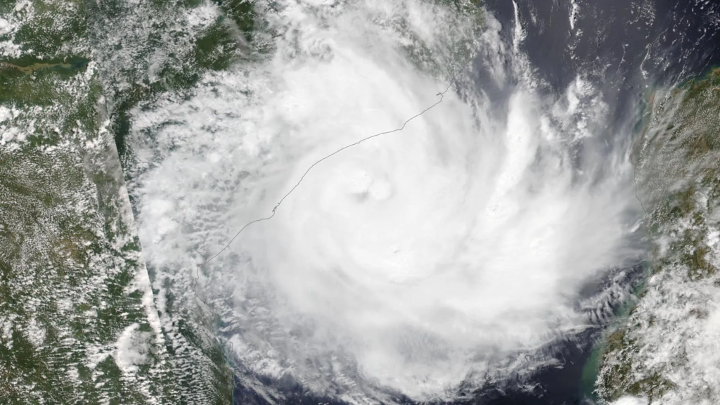
Visible satellite image Tropical Cyclone Freddy on March 10, 2023, as it approached Mozambique. (Image credit: (Image credit: NASA WorldView)
Like a bad illness you just can’t clear, Tropical Cyclone Freddy in the South Indian Ocean just keeps coming back. Since getting named Feb. 6 off the northwest coast of Australia, Freddy has been around an astonishing 33 days and is poised to make the third landfall of its lifetime on Saturday, this time in central Mozambique. Back in February, Freddy made landfall in southern Mozambique as a tropical storm with 70 mph winds, four days after it hit Madagascar as a category 3 storm with 115 mph winds.
Dangerous flooding rains expected over coastal Mozambique
At 7 a.m. EST Friday, Freddy was headed north-northwest at 4 mph as a category 1 storm with 75 mph winds. Once again, conditions were favorable for development, with moderate wind shear of 5-10 knots and sea surface temperatures of 27-28 degrees Celsius (81-82°F). Both the Joint Typhoon Warning Center and La Rèunion Tropical Cyclone Center predict that Freddy will be at least at category 1 strength at landfall, perhaps after some modest intensification.

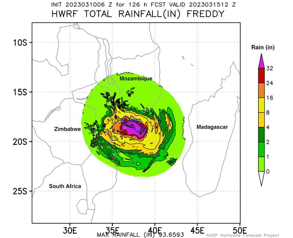
Figure 1. Predicted rainfall (inches) for Tropical Cyclone Freddy for the 5.25-day period ending at 7 a.m. EDT (12Z) Wednesday, March 15, from the 6Z Friday, March 10, run of the HWRF model. The model predicted extreme rains of 24-32 inches along the coast of Mozambique. The La Rèunion Tropical Cyclone Center was predicting lesser peak rains of about 15-20 inches, which would still be devastating. (Image credit: NOAA)
Steering currents for Freddy are weak, and the cyclone is expected to be moving very slowly at landfall and potentially stall out just inland in Mozambique, near the city of Quelimane (population 350,000). This will result in torrential rains, with the La Rèunion Tropical Cyclone Center predicting peak rainfall amounts of 400-500 mm (about 15-20 inches). Fortunately, Freddy is a small storm, and these potentially catastrophic rains will affect a relatively small and sparsely populated area near the coast.
But Saturday’s landfall in Mozambique may not be the end of Freddy, either. Projections from a number of models show Freddy reemerging into the Mozambique Channel early next week and re-intensifying over water.
Freddy holds one world record and may get two more
During Freddy’s long trek across the South Indian Ocean, the storm went through an astounding six separate cycles of rapid intensification (intensifying by at least 35 mph in a 24-hour period), setting a world record. Two of these events occurred because of the storm’s reemergence over water after making landfalls (in Madagascar and in Mozambique); the other four happened when the storm encountered periodically favorable and unfavorable upper-level winds and ocean temperatures. The previous world record was four rounds of rapid intensification, held by the eastern Pacific’s Hurricane Norman (2018), the Atlantic’s Hurricane Emily (2005), and the Pacific’s Hurricane/Typhoon John (1994).
UPDATE: At 12Z Saturday, March 11, Freddy completed an astounding seventh round of rapid intensification, topping out with 110 mph winds just off the coast of Mozambique.
So far, Freddy has generated about 80 units of accumulated cyclone energy, or ACE, a measure of cyclone strength over time, according to Dr. Phil Klotzbach of Colorado State. This smashes the previous Southern Hemisphere single-storm record for ACE of 53 formerly held by Cyclone Fantala of 2016. Only 2006’s Hurricane/Typhoon Ioke in the central and western Pacific had a higher lifetime ACE (85.26) than Freddy. The current Joint Typhoon Warning Center forecast predicts Freddy will have about 83 ACE units by Sunday, so if it reemerges over the Mozambique Channel next week, it could eclipse Ioke’s world record for ACE.
UPDATE: Freddy was downgraded to a tropical depression on March 13, by which time it had accumulated 87 ACE units, setting a new world record for single-storm ACE (see Tweet below):
Freddy is also closing in on the world record for the longest-lived tropical cyclone, held by Hurricane/Typhoon John of 1994 (30.5 days). The Joint Typhoon Warning Center has been tracking Freddy since Feb. 4, though the storm does not qualify as a tropical cyclone during a portion of that time — particularly since after its first landfall in Mozambique, Freddy weakened to a remnant low. Perhaps the best way to characterize records for storm duration is to look at the time spent at tropical storm strength or above (named storm days). As of 12Z Friday, March 10, Freddy has accumulated 24.75 named storm days (see Tweet below). The world record is 28.5 named storm days, held by Hurricane/Typhoon John of 1994.
Freddy’s two other landfalls
According to the Joint Typhoon Warning Center, Freddy peaked with 165 mph winds at 0Z Feb. 16. According to NOAA’s historical hurricane tracks website, this makes Freddy one of only five category 5 storms ever recorded in February on Earth. The only February storm stronger than Freddy (by wind speed) was Tropical Cyclone Winston of 2016, which peaked with 180 mph winds near Fiji on Feb. 20, 2016.
Five days later, on Feb. 21, Freddy made landfall on the central east coast of the island nation of Madagascar, as a weakening category 3 storm with 115 mph winds, according to the final advisory before landfall from the Joint Typhoon Warning Center. Freddy’s rains caused flooding that killed 17 people and displaced over 24,000.
Freddy’s second landfall occurred in southern Mozambique on Feb. 24, as a tropical storm with 70 mph winds. Freddy killed 10 in Mozambique and two in Zimbabwe and destroyed over 28,000 homes.
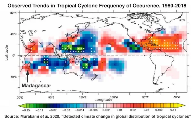
More tropical cyclones have been affecting Mozambique and Madagascar in recent years (red areas on map in Figure 2); this trend is not yet statistically significant (where white dots are). It is unknown to what degree natural variability versus climate change is responsible for this change.

Figure 2. More tropical cyclones have been affecting Madagascar and Mozambique in recent years (red areas on map); this trend is not yet statistically significant (where white dots are). (Image credit: Murakami et al., 2020, “Detected climatic change in global distribution of tropical cyclones,” PNAS May 19, 2020, 117:20, 10706-10714)
Bob Henson contributed to this post.
Website visitors can comment on “Eye on the Storm” posts (see comments policy below). Sign up to receive notices of new postings here.

JEFF MASTERS
Jeff Masters, Ph.D., worked as a hurricane scientist with the NOAA Hurricane Hunters from 1986-1990. After a near-fatal flight into category 5 Hurricane Hugo, he left the Hurricane Hunters to pursue a… More by Jeff Masters
Dr. Jeff Master’s and Bob Henson’s Record-breaking Cyclone Freddy approaches Mozambique — again was first published on Yale Climate Connections, a program of the Yale School of the Environment, available at: http://yaleclimateconnections.org. This work is licensed under a Creative Commons Attribution-Noncommercial-No Derivative Works 2.5 license (CC BY-NC-ND 2.5).
Here are some “ET’s” recorded from around the planet the last couple of days, their consequences, and some extreme temperature outlooks, as well as any extreme precipitation reports:
Here is some new February 2023 climatology:
Here is more climate and weather news from Thursday:
(As usual, this will be a fluid post in which more information gets added during the day as it crosses my radar, crediting all who have put it on-line. Items will be archived on this site for posterity. In most instances click on the pictures of each tweet to see each article. The most noteworthy items will be listed first.)
If you like these posts and my work please contribute via the PayPal widget, which has recently been added to this site. Thanks in advance for any support.)
Guy Walton… “The Climate Guy”