The main purpose of this ongoing blog will be to track planetary extreme, or record temperatures related to climate change. Any reports I see of ETs will be listed below the main topic of the day. I’ll refer to extreme or record temperatures as ETs (not extraterrestrials).😉
Main Topic: All-Time Record Strongest U.S. Heat Dome in Association with Heatwave Conoco
Dear Diary. This week we are seeing the most alarming signs yet that our climate is breaking. On Sunday we had a very rare tropical storm named Hilary slam into Southern California. This is being steered by the elephant in the room, a heat dome that has gotten up to epic proportions from what I’ve dubbed Heatwave Conoco.
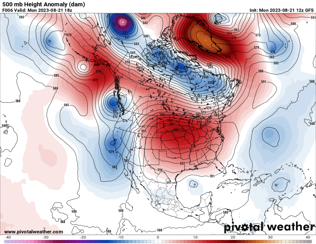
I’ve been following heat dome centers for all of my meteorological career, which has spanned more than 40 years going back to 1982. Never have I seen such high 500 millibar heights, the measure by which mets measure and judge the temperatures of columns of air.
The higher the column of air at 500 millibars, roughly halfway up through the atmosphere, the warmed that column of air is. Yesterday other meteorologists were starting to confirm my suspicion:
I’ll report on any higher 500 millibar heights from today. Thankfully the heat dome in association with Heatwave Conoco will max out today. This thing is a whopper spanning most of the United States:
So, most importantly, what is happening at the toasty surface in association with this record heat dome? To answer this question here is yet another Washington Post article:
Record-breaking central U.S. heat dome brings ‘life-threatening’ conditions – The Washington Post
Record central U.S. heat wave delivers ‘life-threatening’ conditions
Heat indexes topped 130 in Kansas on Sunday. Several days of similar heat are on the way.

August 21, 2023 at 12:16 p.m. EDT
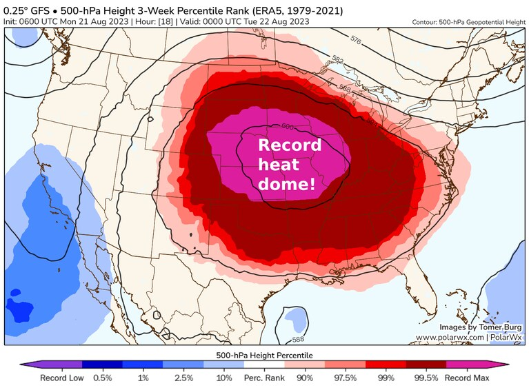
A high-pressure heat dome of record intensity over the central United States. (PolarWx)
More than a third of Americans are under heat alert early this week as a monster heat dome stifles a huge swath of territory across the central United States, threatening the hottest temperatures of summer. As officials warn of “life-threatening” conditions, numerous records in parts of the Midwest could be reached as the heat continues to pummel the South.
Where extreme heat will pose the biggest threat: Look up your city
Excessive-heat warnings stretch from Texas and Louisiana to Wisconsin and Minnesota, including the entire states of Iowa and Missouri. Cities under excessive-heat warnings include Des Moines, Kansas City, Oklahoma City, Dallas and Little Rock. Combinations of heat and humidity will lead to feels-like values of 110 to 120 degrees across much of the Midwest and South, with some spots even surpassing those marks.
That already happened Sunday, with heat indexes in numerous locations topping 120, focused on Kansas, Iowa and Missouri.
More than 200 long-period record highs were set since Friday alone, including an all-time high of 112 degrees in College Station, Tex. Another all-time high was reached in Alexandria, La., where it reached 110 on Saturday. August records were set in Abilene, Tex., at 111, and in Stephenville, Tex., at 110.

Heat alerts in effect early this week. (National Weather Service)
“The prolonged nature of the heat wave combined with very warm overnight temperatures will limit relief from the oppressive daytime heat and compound overall heat impacts,” wrote the National Weather Service’s Weather Prediction Center early Monday.
Indeed, several hundred more record highs and perhaps twice as many record-warm lows are forecast through Friday, including the potential for more monthly or all-time high marks. In the Midwest, the hottest temperatures are expected to shift somewhat eastward over the next several days, bringing record or near-record highs to Minneapolis, Chicago, Memphis and Indianapolis, among other cities.
Intense heat ramps up

Maximum heat index on Sunday.
Heat indexes surpassed 120 degrees in more than a dozen locations across Kansas, Missouri and Iowa on Sunday. In Lawrence, Kan., the heat index reached 134 degrees, from a temperature of 102 degrees and a dew point of 84 degrees. A location in Iowa also recorded the same heat index, but its observations appeared to be corrupted.
“These conditions are untenable for even short durations,” wrote the Weather Service in Kansas City on Sunday.
Looking to put the current heat into perspective, the Weather Service office pointed to a mid-July 1995 heat wave that killed hundreds in Chicago alone.
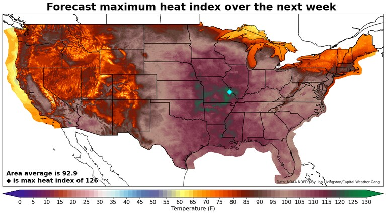
Forecast for maximum heat index through the weekend. (Ian Livingston/The Washington Post)
“Cancel or reschedule activities or move them inside. This is life-threatening heat and any and all precautions should be taken,” it wrote.
The breathtaking temperatures are thanks to a high-pressure heat dome with little precedent in strength. On Sunday evening, a weather balloon released from Topeka in northeastern Kansas recorded one of the highest known U.S. measurements for high-pressure intensity.
“Never have measurements captured a hotter troposphere over the Central U.S.,” wrote NASA atmospheric scientist Ryan Stauffer.
Much more to come this week
To start the week Monday, record highs are set to be threatened from Nebraska to Texas and into the South.
Denver is forecast to reach 99, which would top a record of 97 for the date. Other cities that are expected to break records include Wichita and Dallas, with highs of 106, as well as Shreveport, La., with 105 and Jackson, Miss., with 104.
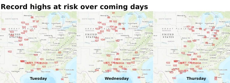
Many records are possible this week. (National Weather Service)
On Tuesday, record heat potential expands, moving into Minneapolis, with a forecast of 99; Chicago, where temperatures are expected to reach 98; and St. Louis, where the forecast is 102. Another large group of records is anticipated from Texas and eastward, where the heat seems never-ending. Austin is up to 44 days in a row at or above 100, a streak that may persist into September.
Similarly expansive extreme heat is expected Wednesday. Records are likely in a region focused on Iowa and again across the South. New Orleans will again rise near and past 100, as will Tallahassee.
Thursday may have the largest footprint of record highs, from the lower Great Lakes southward into the mid-South and then the Gulf Coast and Texas. Chicago should spend its third day near 100, with Detroit making the upper 90s, Louisville similar, and then a bunch of records at risk again from Texas into the South.
Amid the slew of record-warm lows, many cities will fail to drop below 80 at night.
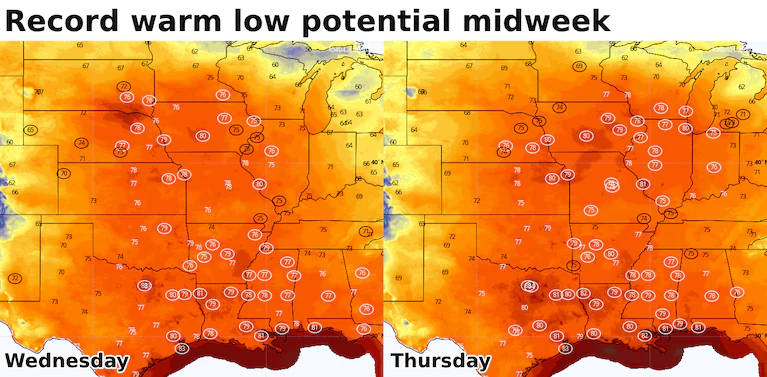
Numerous record warm lows are likely to be set this week. Circled are the ones at risk Wednesday and Thursday. (weatherbell.com)
By Friday and Saturday, a cold front pushes the record heat farther south and east. Mid-90s in Washington, D.C., could threaten a record Friday, with dozens more at risk south and west of there.
Shifting to the weekend, the main focus is back to the Gulf Coast, where New Orleans could be near 100 through Sunday. The city has already seen 12 days at or above 100, destroying the previous annual record of five days in 1980.
No real end in sight
If you’ve been following the summer heat, you probably know the deal. Rather than abate entirely, a shift of the heat dome toward the southwest United States seems a good bet into the last days of August. Thereafter, it may expand eastward again into September.
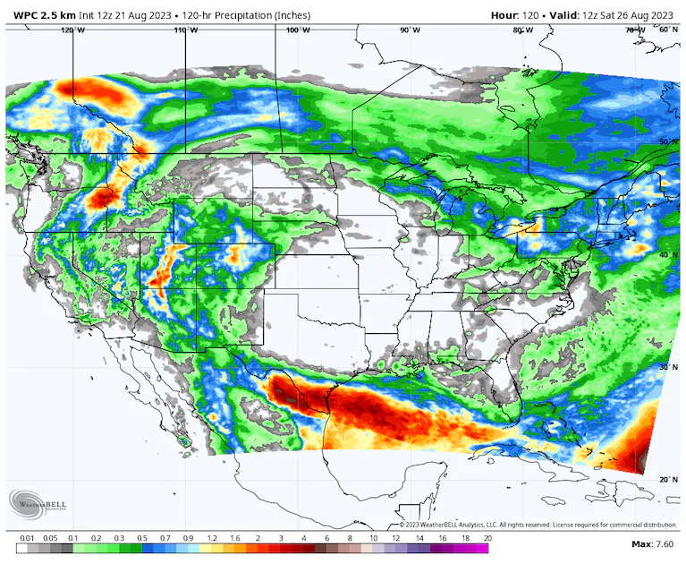
Find the heat dome. A sprawling zone of no precipitation over the next several days does a good job of it. (weatherbell.com)
A notable cool-down to end the month is a good bet in the Northeast, where several days may end up below average for temperatures. Most other portions of the country remain above to well above average.
Any break in a place like Texas — where heat has been anchored for months — appears quite short, if it lasts at all. Temperatures there look to remain 5 to 10 degrees above normal most of the time through the first week of September.
By Ian Livingston Ian Livingston is a forecaster/photographer and information lead for the Capital Weather Gang. By day, Ian is a defense and national security researcher at a D.C. think tank. Twitter
More:
Here are some other “ET’s” recorded from around the planet the last couple of days, their consequences, and some extreme temperature outlooks, as well as any extreme precipitation reports:
Here is some more July 2023 climatology:
Notes on historic Tropical Storm Hilary and the active tropics in general:
Here is more climate and weather news from Monday:
(As usual, this will be a fluid post in which more information gets added during the day as it crosses my radar, crediting all who have put it on-line. Items will be archived on this site for posterity. In most instances click on the pictures of each tweet to see each article. The most noteworthy items will be listed first.)