The main purpose of this ongoing blog will be to track planetary extreme, or record temperatures related to climate change. Any reports I see of ETs will be listed below the main topic of the day. I’ll refer to or record temperatures as ETs (not extraterrestrials).😉
Main Topic: Eye Opening Spate of Record Warmth Across U.S. At End of February
Dear Diary. Today the temperature will get up to 95°Fact Dallas-Fort Worth, Texas and it’s not June…It’s February. A new daily record will be set there by five degrees for today. Heaven help that city if warm trends continue like this into the summer.
By my estimation a couple of thousand record warm reports will occur across the eastern 2/3rds of the U.S. through the 28th to round out February, which will probably be a top five warmest February since records began in 1895.
Most are heralding an early end to what has been a very mild winter…probably the warmest since 1895 also. Yet this very warm weather is ominous and another sign that climate change is making more serious environmental inroads.
Record warmth is usually accompanied by elevated fire danger. What catches my eye today is the large area of NWS fire danger advisories across the western and central Plains:
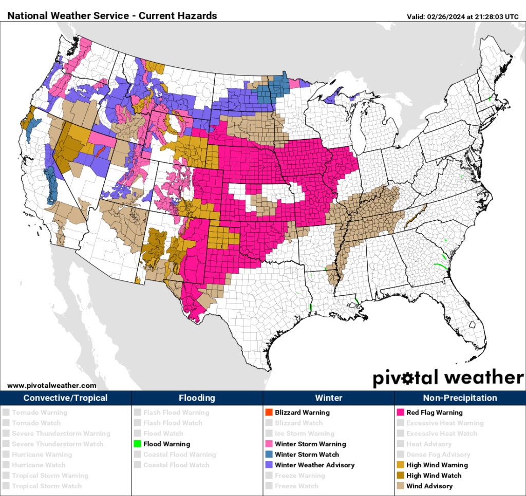
I’ll be reporting on any more large fires should they occur. And severe storms will form very far north for this time of year, to boot:
Here are more details on this warm weather from the Washington Post:
Dallas could hit 95 degrees as warm spell threatens hundreds of records
A huge area of high temperatures 30 or more degrees above normal in the central states is sweeping eastward

Updated February 26, 2024 at 11:55 a.m. EST|Published February 26, 2024 at 11:23 a.m. EST
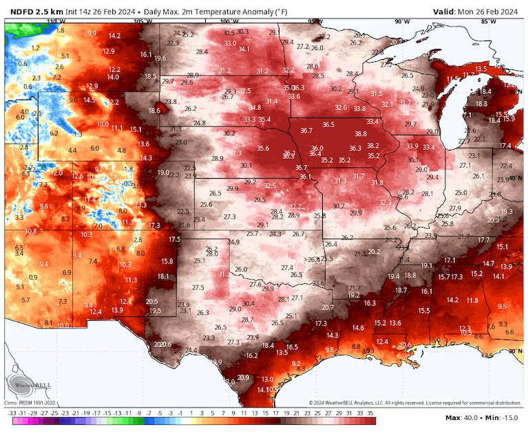
Temperatures are forecast to be 30 to 40 degrees above average across a huge area Monday. (weatherbell.com)
It’s feeling more like early summer than late winter across much of the southern and central United States as February comes to an end.
Through midweek, most of the Plains, Midwest, Great Lakes and Northeast will witness temperatures around 30 degrees above average or even higher. This brings 60s and 70s to the Upper Midwest and Great Lakes region, with 80s and 90s in the central and southern Plains and Mid-South. Dallas could hit 90 to 95 degrees Monday, typical levels for late June or even early July.
Hundreds of calendar-day warm-weather records will be threatened through midweek, and even some all-time highs for February may be in jeopardy. A potent low-pressure system sweeping the nation’s northern tier is drawing the unusually warm and moist air northward, before an intense cold front brings a sudden drop in temperatures.
Spells of abnormally warm weather have been frequent this winter, especially this month and in December. Human-caused climate change and the powerful El Niño climate pattern have fueled the warmth, and this winter could well become the warmest on record in the contiguous United States.
Because of the warmth, the extent of snow cover over the Lower 48 states is, by far, the lowest in at least the past two decades.
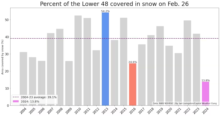
Snow cover percentage on Feb. 26. (Ian Livingston/Capital Weather Gang)
While a brief blast of cold weather will arrive midweek, there’s another surge of unseasonably warm air poised to spread over the nation to begin March.
Monday’s record warmth
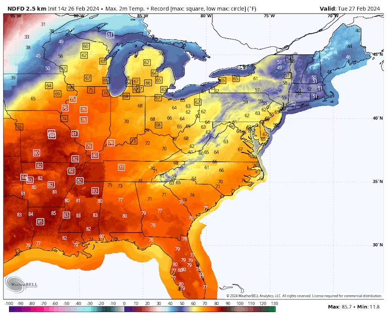
Dozens of record highs are forecast from Texas through the Upper Midwest. Across the southern Plains, temperatures are set to soar into the 80s and 90s while 60s swell as far north as North Dakota and Minnesota, including Bismarck and Minneapolis.
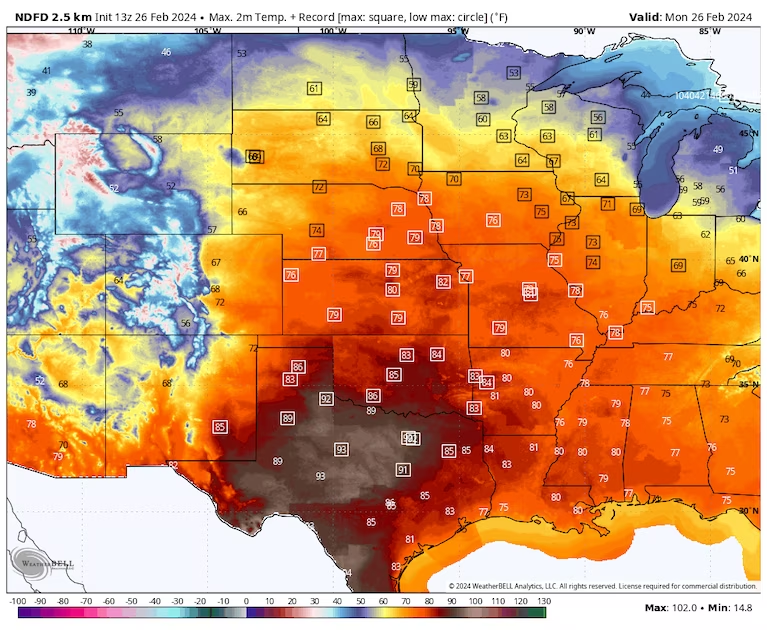
Monday’s forecast highs with potential records highlighted by squares. (weatherbell.com)
Mid-90s are forecast to be common across central and southern Texas — and a few spots could even tickle the century mark.
Dallas is forecast to reach 92 degrees, which would be a calendar-day record. If it gets that hot, it will mark its highest temperature so early in the year since 1996, when it was 95 on Feb. 21 and 93 on Feb. 22, according to NOAA data; it last hit 90 on Feb. 21 last year. Dallas’s highest February temperature on record is 96 degrees, set on the 25th in 1904.
Other locations among those that could set calendar-day records on Monday include:
- Laredo, Tex.: 95 degrees
- Oklahoma City: 86 degrees
- Topeka, Kan.: 83 degrees (would tie February record)
- Grand Island, Neb.: 80 degrees (would tie February record)
- Des Moines: 76 degrees (would be second-warmest on record for February)
- Rapid City, S.D.: 68 degrees
Tuesday
Widespread record warm low temperatures, 20 to 35 degrees above normal, are predicted from Central Texas to the Great Lakes on Tuesday. The lows are forecast to be above freezing as far north as the Upper Peninsula of Michigan. In Dallas, Tuesday’s low may only a settle at 70 degrees.
During the afternoon, the warmest air will shift eastward as a cold front slices through the Plains, focusing the potential for record highs from the South into the Great Lakes. Some warmth will also start to trickle into the Northeast.
The follow locations are among those forecast to post record highs on Tuesday:
- Waco, Tex.: 86 degrees
- Memphis: 82 degrees (would mark February record)
- St Louis: 82 degrees
- Springfield, Ill.: 78 degrees (would tie February record)
- Green Bay, Wis.: 67 degrees (would mark February record)
- Lansing, Mich: 66 degrees
Wednesday
Wednesday will mark the second straight morning during which well over 100 record warm lows are in jeopardy, particularly from the Ohio Valley to the East Coast. In a number of the locations that challenge records, the predicted low temperature will be warmer than the average afternoon high, including:
- Washington, D.C.: Forecast low of 57 degrees (compared to an average high of 52 degrees)
- New York City: Forecast low of 50 degrees (compared to an average high of 45 degrees)
- Boston: Forecast low 48 degrees (compared to an average high of 42 degrees)
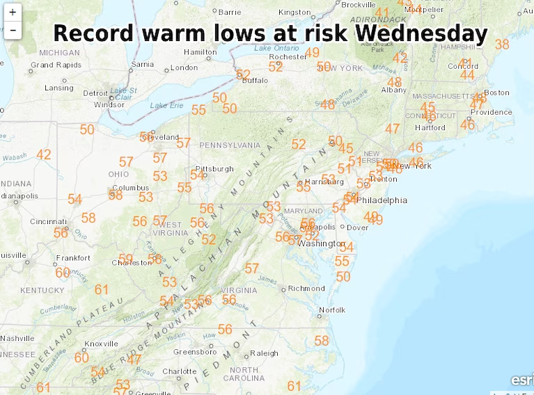
Record warm lows that can be set Wednesday morning. (Weather Prediction Center)
Not as many record afternoon highs are predicted compared to Monday and Tuesday as the cold front advances eastward. Nonetheless, a dozen or so could be threatened in an area focused from the Mid-Atlantic to New England, including in these locations:
- Buffalo: 66 degrees
- Wilmington, Del.: 65 degrees
- Caribou, Maine: 50 degrees
By Thursday, the potential for record warmth will be temporarily over as the cold front pushes off the East Coast.
What will early March bring?
The first day or two of March will produce temperatures about 10 degrees below average for much of the central and eastern United States. But it won’t be long before another surge of warmth.
The next round, forecast for the weekend into early next week, will affect many of the same areas as the one ongoing but may not be quite as intense.
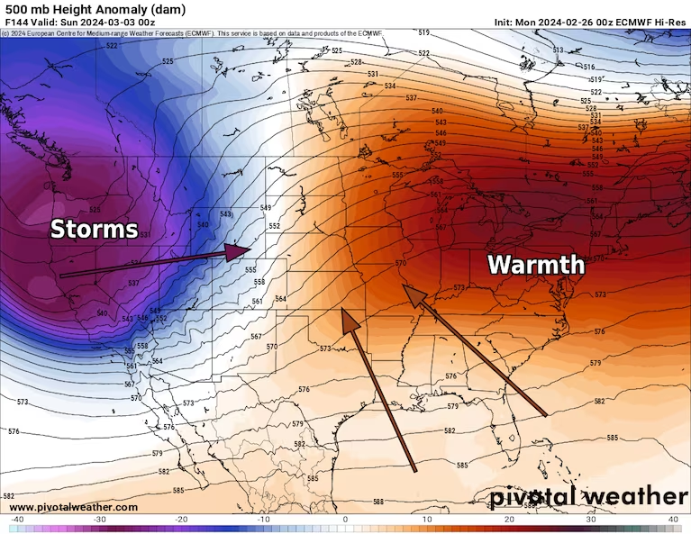
A pattern favoring warmth in the east and cooler air in the west probably returns for early March. (Pivotal Weather)
More:
Here are more “ET’s” recorded from around the planet the last couple of days, their consequences, and some extreme temperature outlooks, as well as any extreme precipitation reports:
Here is more February 2024 and Winter 2023/24 climatology:
Here is More Climate News from Monday:
(As usual, this will be a fluid post in which more information gets added during the day as it crosses my radar, crediting all who have put it on-line. Items will be archived on this site for posterity. In most instances click on the pictures of each tweet to see each article. The most noteworthy items will be listed first.)